NATMAP AT RIALTO
The Commonwealth Government rented accommodation at the Rialto Building at 497 Collins Street Melbourne as far back as the 1920s. From 1959 until 1977, the Melbourne Office of the Commonwealth’s primary topographic mapping agency, the Division of National Mapping (Natmap), occupied office space in the Rialto Building. (From 1956 to 1973, Natmap was administratively located within the Commonwealth Department of National Development and later with successor departments.)
Over the years, Natmap’s Rialto activities were successively under the leadership of Chief Topographic Surveyor, George Robert Lindsay Rim Rimington; Supervising Surveyor, Howard Angas Bill Johnson MBE; Assistant Director, John Dunstan Joe Lines and Assistant Director, Sydney Lorrimar Syd Kirkby MBE. The major Natmap activities undertaken from the Rialto were national surveying and mapping programs covering Australia and its island Territories, Australian Antarctic Territory and the then Australian Territory of Papua and New Guinea.
Surveying and mapping programs that were successfully devised, planned and implemented included :
- the control, mainly 2,540 astrofixes, and the compilation of 207 of the 540 1: 250,000 scale maps of the national R502 uncontoured series (remaining sheets by Army and States);
- the arrangements for the contract acquisition of standard aerial photography of Australia using Wild RC9 cameras with superwide angle lens cones;
- the field work for the of Australian and the high level component of Papua and New Guinea geodetic surveys, pioneering the use of initially the Geodimeter NASM1, then the man portable Tellurometer, mainly models MRA1 and 2, instruments to electronically measure distances between points up to 50 kilometres apart;
- airborne distance measuring using the Aerodist MRC2 system to electronically measure some 3,020 lines that fixed the positions of a network of some 485 mapping control stations over much of mainland Australia and some offshore areas;
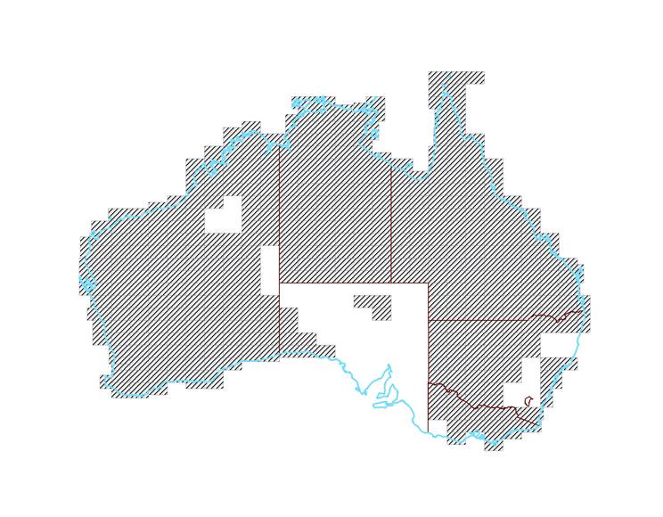
- airborne terrain heighting, initially using Airborne Profile Recorder, CARL Mark V, and later the Department of Supply, Weapons Research Establishment, Laser Terrain Profiler Mark 1, also marketed as WREMAPS-1, over more than 70% of the Australian mainland;
- vehicle based terrain heighting using the then state of the art Sperry-Sun Rand, Johnson Ground Elevation Meter via its uniquely integrated fifth wheel;
- the introduction to Australia of automated photogrammetry via the Wild Model IV, B8 Stereomat and Zeiss Jena Topocart, for orthophotograph (all the features in the photograph are truly positioned at scale) generation, resulting in the production of 783 1: 100,000 scale orthophotomaps; and
- by an agreement between the Director of the Australian Antarctic Division (that run the Australian National Antarctic Research Expeditions - ANARE) and Natmap’s Director, the geodetic and topographic surveys, aerial photography and the compilation of maps of Australian Antarctic Territory.
In the later years when Natmap’s Rialto activities had peak staffing of around 150 people, these surveyors, technicians, photogrammetrists, draftsmen and clerks were mostly accommodated on the First and Second Floors of the Rialto. In addition, there was some storage on the Top Floor and at the laneway level in the Basement, with its cool, stable atmospheric conditions, a vault was located for the storage of the aerial photography negatives. The Basement also housed a carpentry workshop. The Flinders Lane end of the Lower Ground Floor was occupied by the store. The store housed, maintained and issued all technical surveying instruments, camping equipment, and vehicle tools associated with Natmap’s office activities and field survey and mapping operations in remote areas of Australia and its offshore Territories.
Apart from a few rooms that required air conditioning for computer or specialised mapping equipment, most rooms had no heating or cooling. In the extreme heat and cold of Melbourne’s seasons working conditions were far from ideal on many days.
At the Collins Street end of the Second Floor, the Assistant Director and other executive officers, along with the board room, reception and a small administrative staff, were accommodated. An old walk in safe was converted to field book storage. The remaining rooms on this floor were occupied over the years by field and/or office staff engaged on :
The Geodetic Survey of Australia (1959 - 1969);
Map examination surveys (1970 – 1977);
Ground marking for Aerodist, planning and field support (1968 – 1970);
Mapping control surveys (1970 – 1977);
Aerodist planning, field support and field data reductions (1963 - 1976);
Vehicle based terrain heighting using the Johnson Ground Elevation Meter (1964 - 1970);
Airborne Profile Recorder reductions and later Laser Terrain Profiling planning, field support and field data reductions (1962 – 1977);
Operating two Wild B8 Stereomats for orthophotograph generation (1968 – 1976) (this was the only room with airconditioning for many years);
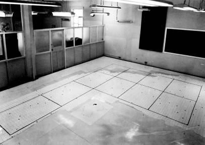
Operating one further Wild B8 Stereomat and two Zeiss Jena Topocarts for orthophotograph generation and subsequent orthophotomap assembly (1970 – 1976) (this room was also airconditioned and had to have the floor strengthened to take the weight of the machines);
Electronic equipment testing and maintenance; and
Staff field survey training.
The First Floor accommodated several teams with office and layout space for preparing and laying down slotted template assemblies, and managing pre and post contract manual stereoplotting activities. (A slotted template assembly is a semi mechanical, graphical method of extending the sparse, surveyed, perimeter mapping control of a photogrammetric block to the individual aerial photographs within that block). A group responsible for the registration, storage and control of survey and mapping information including field books and aerial photography was located in the central rooms of the floor. This group also offered a limited product ordering service. A nearby room housed a small technical library. At the Collins Street end of the floor was the group responsible for the geodetic and topographic surveys, aerial photography and the compilation of maps of Australian Antarctic Territory. Over the years this floor also accommodated staff engaged on :
The horizontal photogrammetric control and compilation of 1: 250,000 scale maps of the R502 uncontoured series and later National Topographic Map Series (NTMS);
Topographic mapping of Papua New Guinea;
Manual stereoplotting using Kail Radial Line Plotter, Zeiss Stereotope, Wild A6, Wild B8 and Kern PG2 machines; and
Full aerial photograph rectification in the small darkroom housing the Zeiss Oberkochen SEG V rectifier.
Photographs
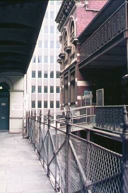
Second Floor balcony looking to Collins Street.
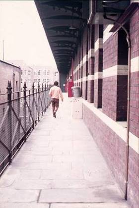
Second Floor balcony looking to Flinders Lane.
First Floor – slotted template assembly.

First Floor - Zeiss Stereotopes for manual stereoplotting from aerial photographs.
First Floor - Wild A6 machines for manual stereoplotting from aerial photographs.
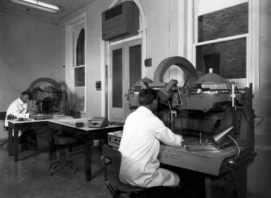
First Floor - Wild B8 machines for manual stereoplotting from aerial photographs.
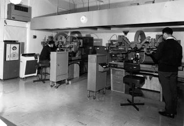
Second Floor - Wild B8 Stereomats for fully automated orthophotograph generation.
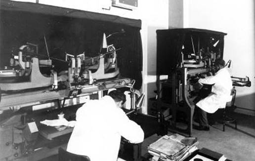
Second Floor – Zeiss Jena Topocarts for semi automated orthophotograph generation.
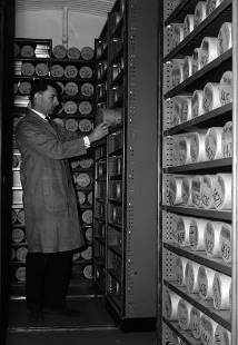
Basement - aerial film vault.
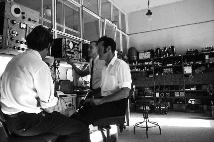
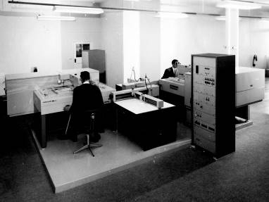
Second Floor - Electronics workshop.
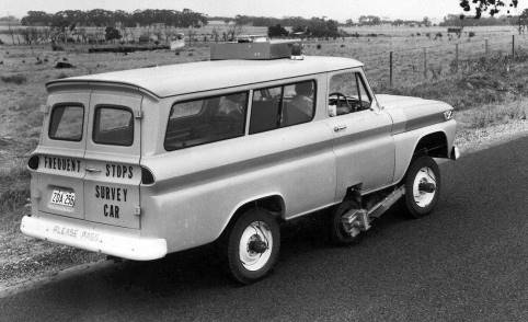
Sperry-Sun Rand, Johnson Ground Elevation Meter used for vehicle based terrain heighting via an integrated fifth wheel.
Maps
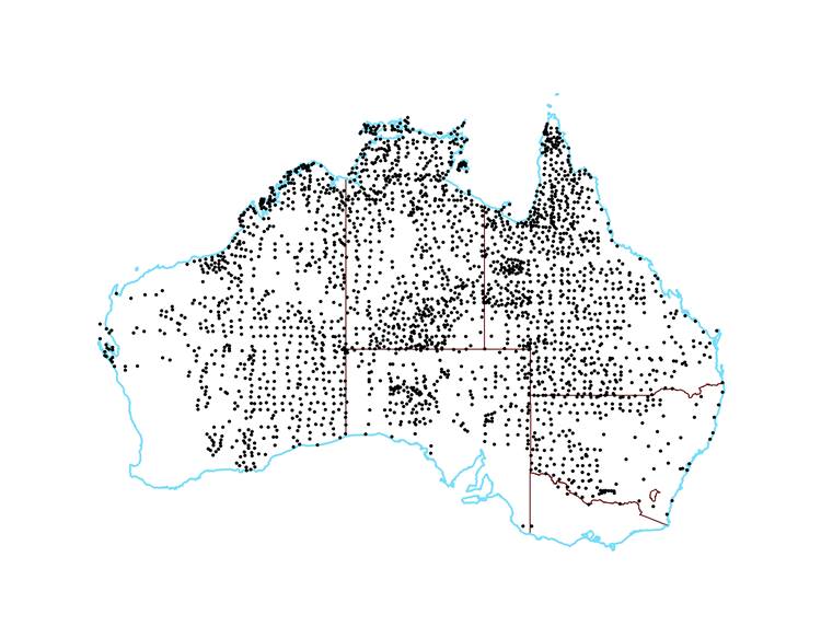
Location of 2,540 astrofixes used for the R502 series mapping program control.
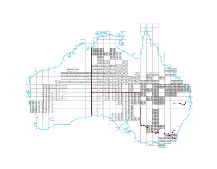
The 207 map sheets compiled as Natmap’s part of the R502 series mapping program.
Standard Wild RC9 aerial photography coverage acquired.
Natmap’s field survey contribution to the Geodetic Survey of Australia.
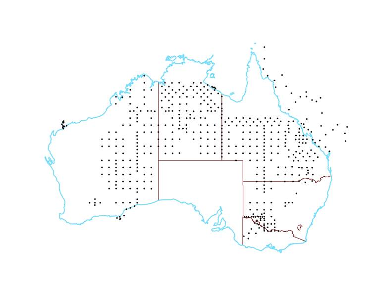
485 Aerodist survey marks established for map control.
The some 3,020 Aerodist lines measured to fix the 485 survey marks for map control.
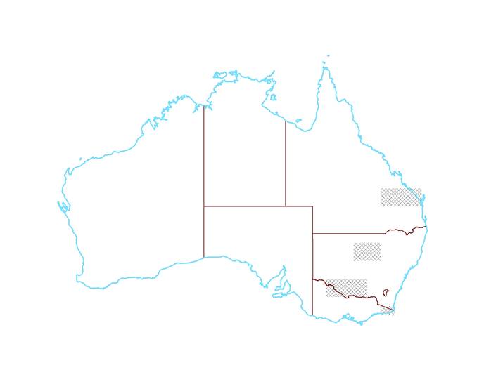
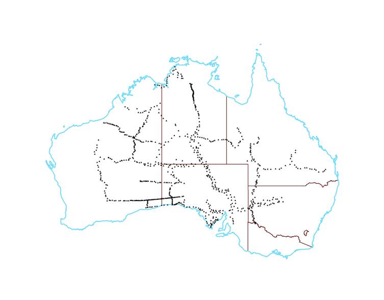
Areas where terrain heights for mapping were acquired by the Sperry-Sun Rand, Johnson Ground Elevation Meter.
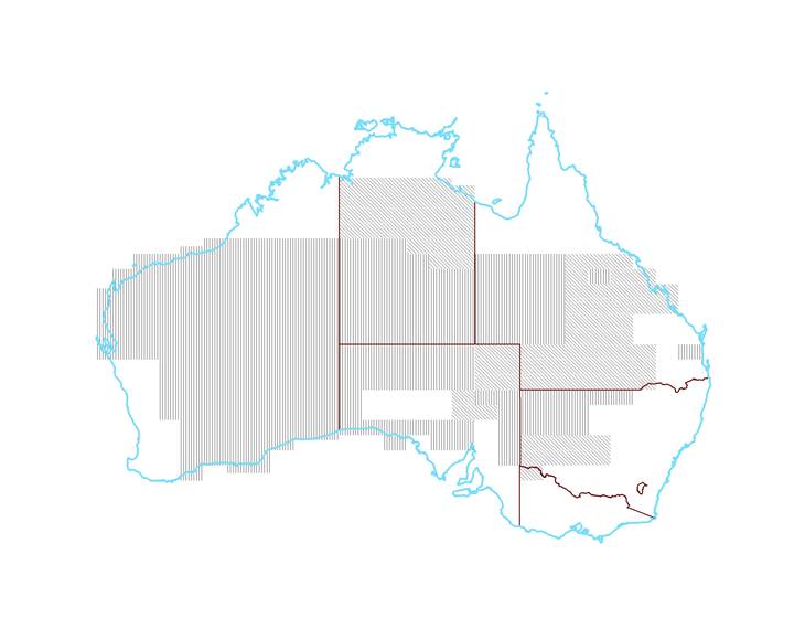
Areas where terrain heights for mapping were acquired by the Airborne Profile Recorder, CARL Mark V (diagonal stripes), and the Laser Terrain Profiler Mark 1 (vertical stripes).
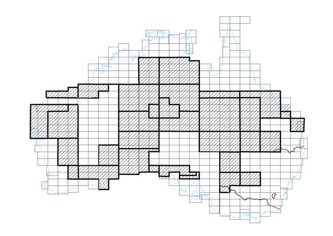
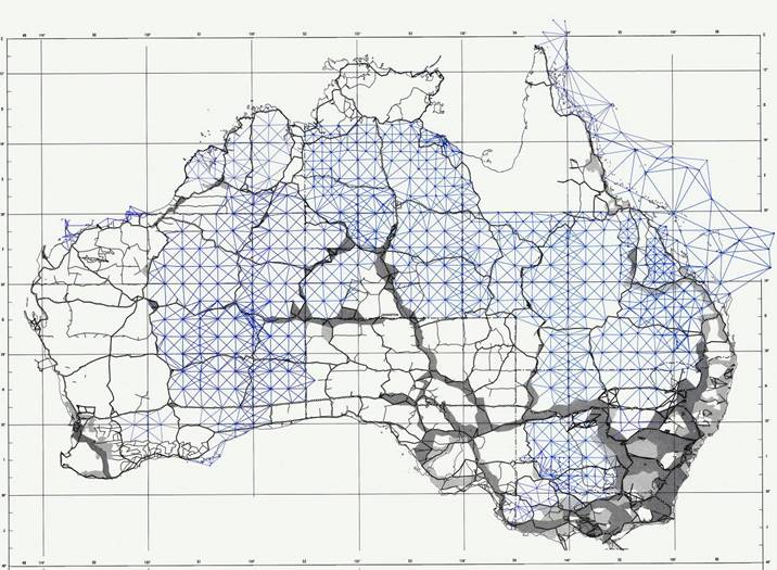
Photogrammetric blocks of 1: 250,000 scale map sheets where horizontal control was intensified by a slotted template assembly.
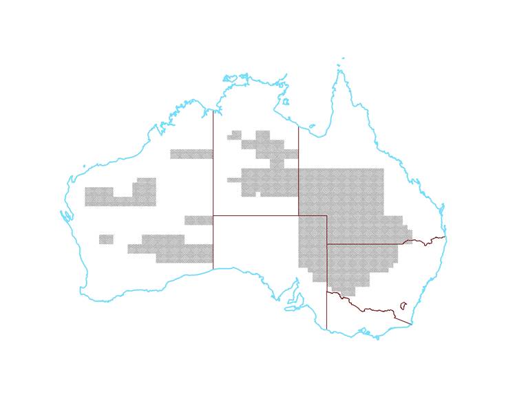
783 1: 100,000 scale orthophotomaps produced from orthophotographs.
Compiled January 2018, by Paul Wise and Laurie McLean.