DEPARTMENT OF NATIONAL DEVELOPMENT
DIVISION OF NATIONAL MAPPING
RECONNAISSANCE REPORT
BY
H. A. JOHNSON
SENIOR TOPOGRAPHIC SURVEYOR
ON
PROPOSED GEODETIC SURVEY
MT. HARVEST TO CARNEGIE HOMESTEAD
JUNE 1958
POSSIBLE GEODETIC SURVEY
TOMKINSON RANGES (S.A.) TO CARNARVON RANGES (W.A.).
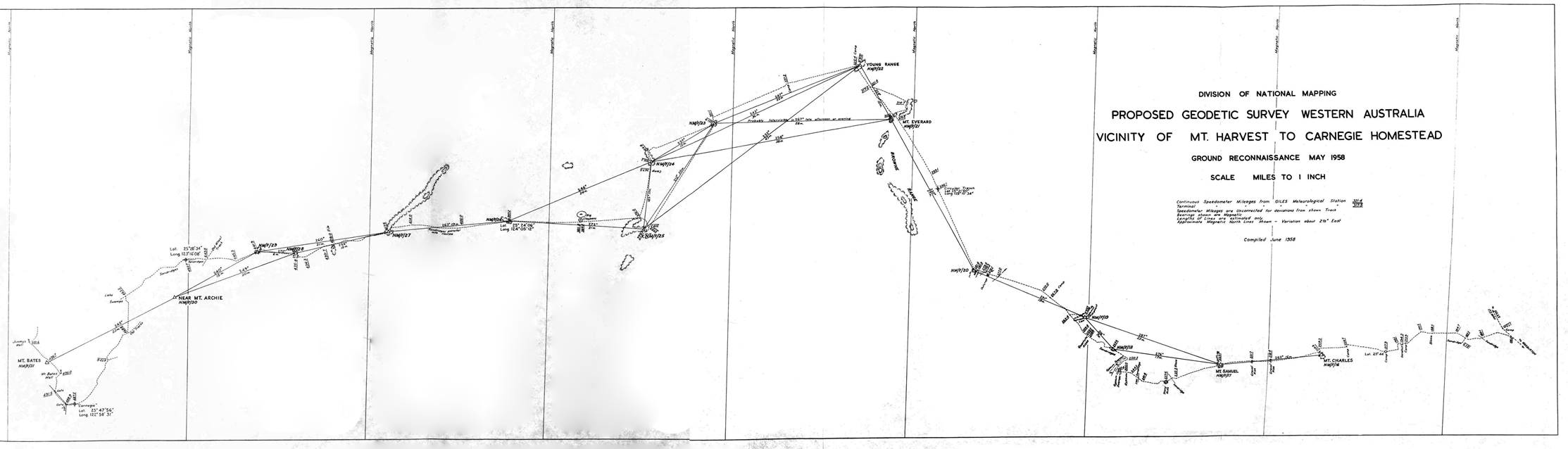
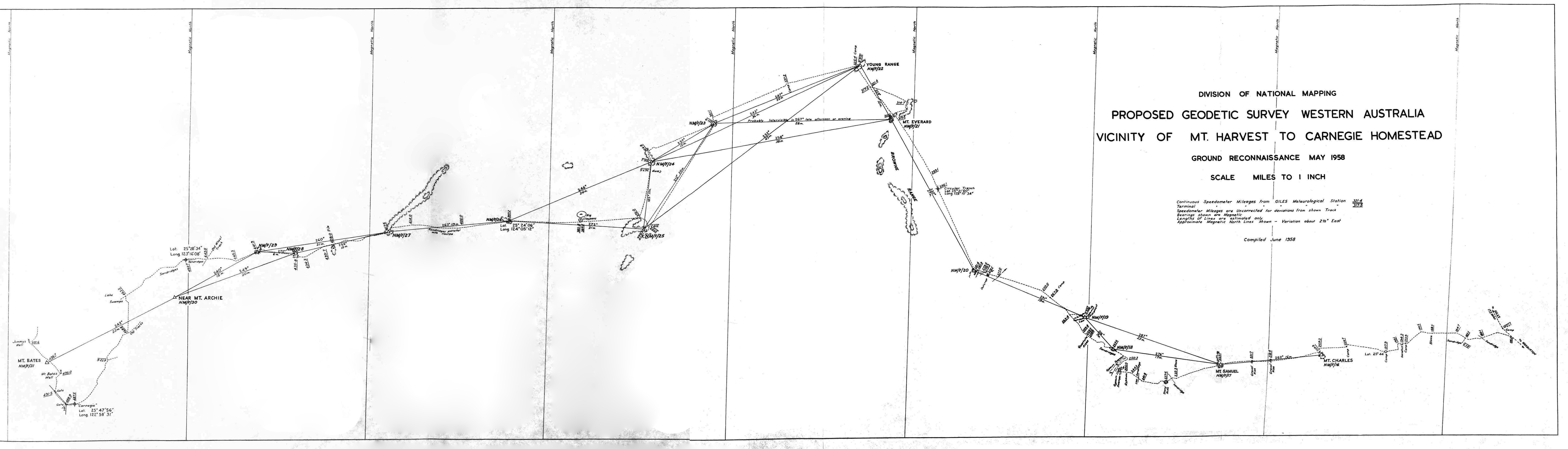
SECTION OF GROUND RECONNAISSANCE FROM VICINITY OF MT. HARVEST TO CARNEGIE HOMESTEAD
14th - 28th MAY 1958.
1. PRELIMINARY AERIAL RECONNAISSANCE.
On 26th and 27th September 1957, the Director of National Mapping (B.P. Lambert) and Weapons Research Establishment Chief Reconnaissance Officer (T.R. Nossiter) made an aerial reconnaissance to investigate the possibility of taking geodetic control by theodolite and Tellurometer traverse, from near the N.T. - S.A. - W.A. corner to the Carnarvon Ranges in W.A. and gave a favourable report.
This survey would supply early control into Broome for the Woomera Range, and make a valuable link in the main geodetic scheme covering Australia, and arrangements were made for ground reconnaissance and selection of traverse stations in May 1958, and at the same time to inspect the going for a possible graded track as a supply line.
2. COMMENCING POINT IN VICINITY OF MT. HARVEST.
A track is being graded from Giles Meteorological Station to Warburton Mission, the track head on 14th May, being 173 miles from Giles. The track to the West will probably turn Westerly from the Giles-Warburton track at about 175.3 miles.
A tentative traverse has been selected from near the Western end of the Rawlinson Range to the Bedford Range and across to this graded track near 116 or 121 mile point then generally South near graded track in undulating, gravelly and sandridge country and across to a high sandridge near the 183.1 mile point on the Westward reconnaissance route. The establishment of this geodetic traverse, however is subject to reconnaissance from Mt. Davies in S.A. on the northern side of the Warburton Ranges to Mt. Harvest and Mt. Charles, to be investigated shortly.
3. MEMBERS AND VEHICLES IN GROUND RECONNAISSANCE PARTY.
The following members and vehicles formed the ground reconnaissance party:‑
|
Weapons Research Establishment |
||
|
Trevor Reginald Nossiter |
OIC Engineering Reconnaissance Section |
Landrover 88" |
|
Leonard Beadell |
Range Reconnaissance Officer |
Landrover 88" |
|
Walter Batchelor MacDougall |
Native Patrol Officer |
Landrover 88" |
|
R. Smith |
Mechanic |
Unimog |
|
Division of National Mapping |
||
|
Howard Angas Johnson |
Senior Surveyor |
Landrover 109" |
[Editor's note : Beadell's recall of this reconnaissance may be read via this link].
The three W.R.E. Landrovers were fitted with stout wire front grilles, hard sides and tops and bough rods, underneath shields (see later references).
The Unimog had temporarily fitted wooden sides and bough rods. Johnson's 109" Landrover had normal canvas canopy with no bough rods or grille and a limited amount of underneath protection.
4. DIARY OF TRIP.
WEDNESDAY 14th MAY 1958 - Vehicles loaded with petrol and water, and party left 173 mile camp at 1400 hours. Nossiter, MacDougall, Smith at high sandridge near 183.1 and Beadell and Johnson to sandridge near 194.4 at nightfall, proving line with lights.
THURSDAY 15th MAY 1958 - Beadell and Johnson selected point near 197.9 almost intervisible with 183.1, but cloud and wireless difficulties precluded proving. In case of non-intervisibility, before proceeding, established intervisibility of 194.4 with 204.7. Sun Latitude at 197.9 is 25°44’South.
Beadell and Johnson to 204.7 and proved to 197.9 at night with lights.
FRIDAY 16th MAY 1958 - All party assembled at 204.7, thence to Mt. Charles, a definite flat topped residual near 209.9.
Mt. Charles gives better rays from it than the gradually rising, wider topped ground about 74 miles to North-West, also better connection towards Mt. Harvest.
From Mt. Charles best route to Mt. Samuel was chosen to avoid thicker mulga, with further selection from open rises along the route, and by climbing on Rover roof. Mt. Samuel seen as distinctive point from Mt. Charles and all party travelled towards it, arriving at Sunset, 227.1 miles.
Evening light inspection with binoculars westwards for likely route, and Director's aerial reconnaissance notes and Forrest's and Carnegie's diaries thoroughly reread several times.
SATURDAY 17th MAY 1958 - Further minute examination at dawn, during refraction distortions, and after refraction had settled down with easterly light. Indefinite but apparently hard, undulating country could be seen Westerly and W.N.W., and aided by aerial reconnaissance notes of few (and those E-W) sandridges to the North, and Carnegie's description of swampy ground to the South, the W.N.W. route was chosen in preference to the more S.W. route to the known high points of Remarkable Peak, Worsnop etc.
All party left Mt. Samuel, 227.1, along best route to avoid thicker mulga. Gypsum ridges and samphire fringed, swampy areas of gypsum lakes, with typically soft edges, were met, and after the speed-governed Unimog and a Landrover had been bogged, party turned N.E. to avoid this area. Camped 249.8.
SUNDAY 18th MAY 1958 - Beadell and Johnson left at dawn to select point before low rays became “watery” sights. Rest of party left after wireless schedule with Woomera, which was usual procedure for this reconnaissance until completion. Headed northern end of swamp at 250.3, and selected NMF/18 on a firmly held sandridge at 253.6. All party continued through not very difficult sandridge country to high, gravelly topped rises and selected NMF/19 near 263.4 (about 2.5 miles bearing 97° from 263.4). Camped 267.9.
MONDAY 19th MAY 1958 - Beadell and Johnson left at dawn, others after wireless schedule. From 263.4 best route had been selected W.N.W. towards distinctive bluff on prominent range. NMF/20 selected on this commanding bluff near 281.1, from which most of the Brown Range could be seen. Obvious traverse course was to follow the high points, and the direction of most likely ones was also in the direction of the apparently better going with less scrub. Accordingly traverse swung 330° towards a distinctive peak (Mt. Everard) with an adjacent lower peak and longer flat tops. Camp and astro-fix at 296.1. Latitude 25°21'00"S, Longitude 125°10'34"E.
TUESDAY 20th MAY 1958 - Beadell and Johnson left at dawn; others after wireless schedule. Investigated Mt. Everard and adjacent points near 310.9. Selected Mt. Everard NMF/21. A collection of punctures on arrival here required attention. Although the Young Range 329° magnetic bearing was further north than general direction of traverse, such a high and distinctive feature could not be passed for indefinite undulations, without investigation. At 311.2, Nossiter, MacDougall and Smith headed direct for the Young Range, and Johnson and Beadell turned N.E. to reconnoitre the N.E. end of the Browne Range, which constricts to a long, narrow ridge with numerous small caves on its low cliffs, and with an isolated flat top (probably Mt. Gordon) about 0.5 miles bearing 105° from N.E. end of Browne Range. Camp at 314.7.
WEDNESDAY 21st MAY 1958 - Beadell and Johnson completed reconnaissance N.E. end of Browne Range and joined party at Young Range at foot of distinctive, flat topped residual (probably Charles Knob) at 325.4. The highest point, NMF/22, is about 0.6 miles bearing 65° from 325.4, and a very commanding position, from which a series of flat tops (231°-235°) were seen over 40 miles distant; and less distinctive, but a high ridge (243°), about 40 miles.
These rays passed over lower, but still high, intervening undulations, and apparently good going. All party continued, and camped 337.2.
THURSDAY 22nd MAY 1958 - Usual departure. Investigated high undulation at 337.7, but selected better position on high undulation at 351.9, NMF/23. Here Nossiter, MacDougall and Smith headed 213° to high flat tops, and Beadell and Johnson continued to mulga covered escarpment selecting NMF/24 at 366.3. Camp at 367.5.
FRIDAY 23rd MAY 1958 - Beadell and Johnson continued at dawn to western end of flat tops near 376.0, reconnoitred, then went S.E. generally to meet others near 378.5. Selected NMF/25 on this wide topped residual, fairly thickly timbered, for best rays. All party then continued westerly from 376.0 to reach NMF/26 at 397.2 at dusk. Camp and astro-fix Latitude 25°24'06", Longitude 124°05’12"E.
SATURDAY 24th MAY 1958 - Reconnoitred this isolated, commanding hill from which good rays could be taken in any direction. The full length of the Fame Range could be seen with some good, open flat tops on N.E. end. After wireless schedule all party continued westerly to southern end of Fame Range, traversing some rough spinifex and running with a few sandridges. After some tree climbing, because of the flat, wide and timbered top, NMF/27 was selected near 417.5 avoiding most of the heavy clearing and long ground rays. Camped 418.1.
SUNDAY 25th MAY 1958 - Waited for wireless message and lost several hours in replacing broken speedometer cable at 421.7 on Johnson's Landrover, a bough damaging both inner and outer cable.
Beadell and Johnson investigated northern end of stony ridge near 428.0 whilst rest of party continued to further ridge at 435.8 for camp, and joined by Beadell and Johnson later, Selected NMF/28 on northern end of this ridge about 0.4 miles north of 435.8.
MONDAY 26th MAY 1958 - At dawn, investigated southern end of this ridge then all party moved to another wide, heavily timbered, flat topped residual where NMF/29 was selected near 441.9 on S.W. end. The points NMF/27, 28, 29 are all intervisible, also the point visited near 428.0, but NMF/28 was inserted in case the low, wide topped residuals, giving rather long getaway rays, cause trouble. The point NMF/30 near Mt. Archie was chosen for this reason, being intervisible with NMF/28 and 29.
From 441.9 route was chosen towards a high sandridge, about 6 miles North of Mt. Archie, in the direction of the sandridge now fairly thick in the S.W. to N.E. sector generally. This high firm sandridge at 452.7 was reached in time for camp and quick reconnaissance. Astro-fix Latitude 25°28’34”S, Longitude 123°16'08"E.
TUESDAY 27th MAY 1958 - From this sandridge at 452.7, Mts. Archie, Bates and Boucaut could be seen. W.R.E. members of party had other appointments, and it was decided to reach Carnegie H.S. as soon as possible for dispersal, and for Johnson to visit point near Mt. Archie later. Party turned for Carnegie H.S. after running the sandridges out at 459.3, and after winding round samphire swamps and arms of Lake Buchanan to its main shore, retraced its tracks some miles to 463.2 to turn south and clear the swamps, before turning generally S.S.W. towards Carnegie H.S. at 468.8, on station track. Camped 478.3 for tidy up after tea.
WEDNESDAY 28th MAY 1958 - All party continued to Carnegie H.S. at 477.5. Latitude 21°47'56"S, Longitude 122°58'31"E, to very hospitable and friendly welcome by Mr. and Mrs. Roy Linke. Here party filled vehicles with petrol, delivery of which had previously been arranged by Nossiter from the local supplier at Wiluna, and filled tanks with water; made final discussions for plans, and dispersed, Johnson continuing reconnaissance of Mt. Bates and near Mt. Archie and on towards Carnarvon Ranges.
5. RECORDING THE TRAVERSE.
The traverse was recorded by speedometer and compass readings, "going" and vegetation notes also being booked. Each night the traverse was plotted as carefully as possible at 4 mile to an inch from recorded speedometer readings. A 6" protractor on a gridded plot, taken as magnetically oriented, was used, with recorded speedometer readings. It was thought that the fitting of this plot to the astro-fixes could best be done later in the office, so no attempt was made to adjust the work to the astro-fixes or for the probable 5% scale error in weaving through the brushes. However, the traverse was adjusted to the overall through magnetic bearing from traverse station to traverse station wherever possible. Astro-fixes were observed by L. Beadell with 3½" Tavistock theodolite. Prismatic compass was read outside the Rover or from its roof, from which position, provided no vehicle was near, bearings seemed to be within ½° or less.
It is thought that close directions and distances for field use will be able to be scaled from copies of the adjusted plot which will be prepared both at 4 and at 10 miles to an inch, and it is presumed this report will be read in conjunction with the copy of this plot on which frequent mileages have been recorded, for future quick reference and scaling, when using it in the field.
6. VEHICLES AND W.R.E. MODIFICATIONS.
All the Landrovers performed well. There were few watercourses, and no very narrow or steep ones, and no very rough stony ridges, or difficult sandridges to cross.
Mulga was thick in some belts and the way the W.R.E. Landrovers (with hard sides and roofs; bough rails; strong wire mesh right across the front which precludes penetration of the radiator by stakes, and protects the mudguards; and tin dish type of underneath protection from branches in the fan belt or from tearing off electrical leads or speedometer cables) penetrate scrub must be seen to be believed. These modifications are made to Department of Supply specifications and in time saved in axework and repairs would pay for themselves in a few weeks.
The rods and grille break off many sticks and limbs and this considerably helped Johnson's canvas topped Landrover, though some boughs still required axework. The W.R.E. modified vehicle penetrates scrub with ease, which would rip the canvas top and probably the mudguards from an unmodified, canvas canopied vehicle at the first attempt.
The long 109" Wheel base, and generally uncompartmented interior are preferred for National Mapping work, however, and lighter dural bough frames would be worth investigating.
The ability to go fairly, straight on survey work, from point to point, is almost always time saving and makes for speed and accuracy in establishing position, either on a map, plot or photograph.
Without Beadell's leading W.R.E. Landrover the reconnaissance by canvas canopied vehicle would have been much longer, involving more axework; absorbing time in avoiding scrub and probable delays due to underneath damage.
The thorough, fine gauze screening fitted by Department of Supply workshops of every opening to the radiator, plus the usual fine wire screen, kept Johnson's radiator almost free of the very penetrating spinifex seed husks, which formed an inch thick in a few minutes after brushing clean, on the fine wire screen. Every opening must be gauzed over as a thoroughly choked radiator is extremely hard to clean with any medium, and should it get wet, together with the dust, it forms a brick.
At 173 mile camp Johnson's radiator, which for some time had been overheating on heavy sandy tracks, was found to be completely gummed up inside with grease.
The thermostat, an incredible looking object of grease and rust, and apparently still going through the motions of opening and shutting, was permanently removed and a mixture of kerosene and water put in the emptied cooling system and the engine run for some time with a bag over the radiator, and then drained again, with eminently satisfactory results, no water being used in this radiator on the rest of the trip, or in the other vehicles, despite quite warm days and often tail winds.
MacDougall's Landrover dragged an Army type trailer carrying 40 gallons of water and two 44 gallon drums of petrol - a creditable performance, as some sandridges had to be negotiated. Smith's Unimog had been added to the party for testing on such work at short notice. It has great power, especially when its differentials are locked, and much greater payload than a Landrover, in addition to dragging a heavy trailer if required. It is a diesel engine. For certain survey work, probably a blade could be fitted to it to grade a narrow path through rough, anthilly spinifex, or bad puncture producing bushes; and properly screened to break a path through scrub. Should there be 18" walls or equivalent to be climbed, it seems fully capable of performing it. Its special European type wheels apparently cannot be fitted with Australian tyres, nor apparently can Australian wheels be fitted to overcome this difficulty. More clarification on these two points seems warranted.
It is not a satisfactory long-range reconnaissance vehicle. Speed-governed to 30mph saves it from being over-driven on good roads - it also precludes a quick rush over a boggy patch or at a sandridge. Over long expanses of rough spinifex, its very high clearance and independent springing give a rollicking ride to its usually freely expressive, cramped, hot driver.
7. TYRES.
The following is a summary of vehicle positions and tyre performances.
BEADELL'S LANDROVER. Breaking track and bearing full brunt of track making, its tyres suffering a tremendous onslaught. 7.00 x 16, 8 ply, road tread - 5 punctures.
JOHNSON'S LANDROVER. Usually second, throwing off worst of uprooted roots and cutting remaining bad overhead boughs. 7.00 x 16, 8 ply, Australian Dunlop Highway tread - no punctures.
NOSSITER'S LANDROVER. Usually third, but on several occasions breaking track on alternative routes. 9.00 x 13 sand tyres which performed well in sand, but were thin and vulnerable in scrub - 11 punctures.
SMITH'S UNIMOG. Usually fourth. Bar tread. Lost count after 40 punctures and some concern as to whether the convoy's patches would suffice for the trip. Bar treads dig down in sand and fill up in the mud.
MacDOUGALL'S LANDROVER AND TRAILER. Usually fifth. 7.00 x 16, 8 ply, road tread, - no punctures.
In sand and spinifex, pressures for 7.00 x 16, 8 ply tyres are best kept between 18-20lbs, or when loaded, the tyre viewed from front or immediately behind it inflated to give the merest suggestion of a bulge. This is likely to give far longer life to expensive transmissions, and wheel bearings, as well as negotiating bad sand. On a very wide, soft creek or bad sandridge, pressures dropped to 15lbs (by gauge) and immediately pumped up on crossing will usually help; below 15lbs the valves are likely to be torn off. The 18-20lb pressure is also likely to give less punctures - the tyres folding over the objects.
It is very noticeable that where rough spinifex can be traversed in high ratio, 2 wheel drive gives a smoother and easier transmission than the rigid 4 wheel drive. At all times, however, with a Landrover and its four high revving cylinders, revolutions must be kept up by use of the gears, and no labouring or near labouring permitted.
There is a limit to what can be thrown off a track, and where potential puncture producing objects must be driven over, the slowest possible crawl in low ratio is likely to give fewest punctures; but there is little chance of escaping, if the unrotted, dagger like roots of any acacia (mulga or the various bushes) lying dead on the ground are fairly rolled over by a wheel.
8. PETROL COMSUMPTION.
Johnson's long wheel base Landrover, in the 366 miles traversed from 173 mile camp to Carnegie H.S., used 43 gallons of petrol, approximately 8.5 miles per gallon. It is thought the shorter based Landrovers did a little better, especially Nossiter's large sand tyred vehicle.
Vehicle was generally in 1st or 2nd high ratio, 2 wheel drive, or 3rd or 4th low ratio, 4 wheel drive. There were a few occasions where 3rd high ratio, was engaged, but not for very far, because of the unknown hazards of roots etc.
In heavy sandridge or rough stony country, where 1st and 2nd low ratios are used most of the time, petrol consumption is but 2-3 miles per gallon.
9. WATER.
No water, other than that carried was seen on the trip. Some limestone areas, noted in the "Going Notes" seemed likely boring prospects. A fortunate, mid winter, heavy shower allowed Forrest and his party to get through Mts. Samuel, Charles and Harvest section to the Warburton Ranges, in his crossing in 1873. A few, but not many, birds and kangaroos were seen. Old camel pads were seen near 246 miles, apparently made by camels coming up from the Southern springs after rain.
It appears that in many places over Australia, old springs have dried up through a fallen water table. Forrest's Weld Spring (in a most likely water setting of limestone and teatree watercourse) is now quite dry. No. 9 Well, nearby, of the Canning Stock Route, is 12 feet to the water.
10. ABORIGINALS.
No signs of any recent visitations of natives were seen on the entire trip.
11. WIRELESS.
Wireless contact was maintained by MacDougall using the W.R.E. Peppercorn set with dipole aerial, to Woomera or Giles, daily.
Since completion of this trip, Johnson's portable Traeger set with locked 7465KC crystals has generally got through to Woomera or Giles, if high, tree free positions are chosen. It has got through fairly clearly to Surveyors Spowers and Ford with similar Traeger sets and telescopic aerials, at 500 to 600 miles, on this locked frequency, about 0845 hours on the occasions used.
12. RANGES AND HILLS.
From Mt. Charles westerly all stations chosen on hard stony ground have been on sedimentary residuals, usually sandstone or quartzite capped, and usually flat topped. 4 wheel drive vehicles can be driven up most of them at selected places, and they are little more than 50-100 feet above the general local area. However in the clear, early morning and late afternoon light they can to seen from 20-50 miles, and they become the distinctive and impressive features they very relatively are in their setting.
They appear to be good hills from a theodolite-Tellurometer traverse viewpoint.
13. PASTORAL COUNTRY
If water is obtainable by boring, there is good pastoral country all through this traversed section. Mulga mentioned in the notes refers to the fine, needle leaved Acacia aneura which generally was a good bushy tree 8’-12’, and being 25’ in any low lying boggy patch.
Other broad leaved acacia bushes were common; and, also scattered through the entire trip and usually more numerous on timbered residuals, was a thick trunked, high (up to 45'), dark and broad leaved acacia (probably A. sp. aff. notabilis). It is called "gidgea" in the Carnegie district but it is quite different from the S.A. gidgea, A. cambagei. In ageing, the leaves grow on the extreme ends of its high, dark barked branches.
Dead-Finish, A. tetragonophylla, was seen occasionally westwards of 245 point, generally on better country.
A red bark-peeling, broad-leaved acacia of the turpentine species, known to the natives as "minnaritchie" was a bad puncture risk where encountered. Generally about 4' high. It grew to 15’ on occasions when its resemblance to the red mulga South Australian (A. cyperophylla) was more pronounced.
The prevailing spinifex seemed to be Triodia irritans but there was also a darker, softer, less prickly and more resinous species at times (T. pungens) mainly in heavier soil. The spinifex thinned out (sometimes completely) in the mulga belts, when other herbage would show up.
A wiry, tufted-rooted grass (Erogrostis)was fairly frequently seen amongst the spinifex over the whole trip.
From the flowering bushes and shrubs, a recent summer rain had penetrated from the West to the 265 mile - east of this the country was practically flowerless.
Predominating amongst the herbage (when clear of the spinifex) was the Ptilotus, of which P. alopecuroides, and another (at first distant glance like saltbush) similar to P.ob vatus or P.incanus, were very thick. At 277.0 point a glade of tall mulga, carpeted with dense mats of grass and P. exaltatus, was a delightful sight. The small P.helipteroides was in frequent and attractive evidence.
Some saltbush (possibly triplex vesicaria) was seen, notably on the western side of Mt. Samuel where the country had been burnt several years ago.
No bluebush of the Kochia pyramidata or similar species was noticed, though a hop bush type was.
The very infrequent grass was all confined to the lower lying, heavy soil, boggy patches.
In well-watered patches the following were fairly thickly growing. Solanum ellioticum; Brunonia australis; Camel bush (Trichodesma zeylanica); Lepidium; Scaevola (several species); Crotalaria dissitiflora; Goodenia; Ipomoea muelleri; Sida platycalyx and Sida petrophila.
Although no parakeelya (Calandrinia) was noticed from a moving truck amongst the spinifex, it is thought one or more species would surely be there, very noticeable when flowering.
Occasional bushes of the wiry Brackysema chambersii were seen amongst the spinifex.
The country seemed free of the very troublesome ground pricklem plants of the Tribulus and Oalotis kind, so prevalent in lower N.T. and upper S.A. where they are probably widely distributed by stock.
A few bigger Grevillea striata (beefwood) were passed, but the predominating ones were G. juncifolia and G. stenobotryta, on the open spinifex flat sandy, and sandridge country.
The prevalent Hakea was thought to be H. intermedia (corkwood) growing about 6'-10' high and with characteristic long, woody winged seeds.
There was another very common tree about 5’-6’ high, with long noodle shaped leaves, a red spidery grevillea flower, but with nearly round, ¾” seeds, woody and opening like a hakea, with the woody section fairly freely leaving the outer shell.
Eremophila and Cassia were thick on the firmer loam or rubble covered loam, and the following were thought to be identified : Eremophila freelingii, E. dlattonii, E. gilesii, Cassia desolata, C. artemisoides, C. eremophila.
The few gum type eucalypts seen grew in the flat watercourses. One known locally as a bloodwood seemed fairly similar to the more eastern one of the same local name. Another was a 20’-30’ high, white trunked, very small leaved tree, with masses of ½" long, pitcher shaped nuts. Another species (only two specimens seen) was a 40' red trunked tree.
In and near the sandridges two mallees were fairly common, one long leaved one with 1" diameter gum-nuts, probably E. pachyphylla and the other E. cramophylla (blue mallee) with double leaf.
A few live desert poplars (Codonocarpus cotinifolius) were seen in the sandier country, with many more, old ones lying on the ground.
A few scattered kurrajongs grow in the sandy flats near 450 miles. No desert oaks (Casuarina decaisneana) were seen on the entire trip, though plenty were growing in the back sandridge country from the Western end of the Rawlinson Ranges to the 100 mile.
Two species of quandong were quite common - one with the well known rough crinkly stone, thought to be Eucarya acuminata; the other, with much smoother thinner stone, and rather tasteless kernel, and darker barked branches. Most trees had recently fruited.
The native currant bush (Plectronia latifolium) grew on all the firmer loamy soil, and from 375-385 miles was in profuse berry and just ripe.
The camel poison bush (Gyrostemen ramulosus) was growing on practically every sandridge, and it was thought a few bushes of the poisonous Gastrolobium grandiflorum (not in flower) were noticed.
The samphire in the swampy ground near 246 mile had especially big, fleshy nodules. Teatree, of the paper bark, swampy ground growing species was about 6'-10' high. There was also a very common bush on all the sandy, old marsh type of country as well as every sandridge, 3-4 feet high, with minute leaves cylindrically arranged on the flower stalks for about 1" from the very small pink and white flower, the flowers completely covering the bush, also thought to be a teatree (Thyptomene maisonneuv).
14. GENERAL.
At any future date there would be little difficulty in forming a graded track in the general vicinity of the reconnaissance route, heading more northerly to miss the swamps of the midway area, and straightening and shortening such a track, which would not need to visit the traverse stations. Chasing the trend of these higher points combined with the aerial reconnaissance knowledge and extracts from Forrest's and Carnegie's journals, certainly helped in following such an easy route, governed greatly by the direction of the few sandridges encountered.
The Landrover does a magnificent effort on this type of work and is very comfortable, the latter being not unimportant when it is one's home for 8-10 months of the year. With the front louvres and side windows properly manipulated, much of the dust can be kept out of the seating area.
It is impossible to have the ideal vehicular set-up to meet every situation in long range survey work when, firstly, the surveyor must drive 1,000 miles and more from his headquarters on various types of surfaced roads and reasonable station tracks, where a trailer is a useful adjunct, and where 9.00 x 13 tyres will steer like a boat and put great strain and wear on the steering system; and when, secondly within the first two or three miles of his field work proper, he may be traversing rough, stony watercourses and ridges, thick mulga belts bristling with potential punctures, and heavy sandridges or bad, wide, fine sand creek crossings.
The compromise in tyres, seems obviously 7.00 x 16, 8 ply, road tread. Ignoring their high puncture incidence, if 9.00 x 13 tyres are placed on the rear wheels, the disadvantages of carrying an extra type of spare wheel, when space and weight are already beyond the premium stage, are clear. 7.50 x 16 tyres on the rear wheels could be worth an experiment, but circumstances of the work should be studied.
Distribution of the load on a trailer over hard surfaced going lightens the work of the transmission system and wheel bearings. In bad sand or mud, it not only increases the strain and risk of their failure, but is a certain stopper to forward progress.
In crossing a bad sandridge, after examination on foot to obviate any turning to miss bushy-held hillocks of sand or wind scours, the best combination of speed and gearing is made to ride in as far as possible on the usually firmer, upper crust. When stopped, it is then tried to pack the sand mechanically sufficiently to cross by repeated backward and forward runs.
This continues until the ridge is passed, investigated elsewhere, or a long tailing-out route taken.
If a side slope is attempted, the vehicle usually slides out of its forward tracks when backing, and with a trailer, becomes more involved.
Far afield, to the driver with mechanical feeling towards his machine (whose temporary loss of function out there can, in the extreme case, bring about the permanent loss of his own) when his run is slowing and he depresses the clutch, the instantaneous stop, as though all your wheels were suddenly taken by giant hands in a grip of iron, is a chilling sensation.
Should wheel bearings go, by the continuous bumping over rough spinifex particularly it may be possible on older models to go 30-50 miles more (before the axle drops too far for further movement) by removing the brake shoes. The floating rear axles of the latest Landrover allow a good chance of returning on the front wheel drive in rear axle or differential failure.
The long wheel base Landrover seems the compromise as an economic vehicle on remote survey work, and it seems impossible, also, not to overload vehicles on such work, when the weight of fuel and water which must be carried are considered. A comparison of the number of failures, which could fairly well be attributed to overloading alone, with the amount of survey and geological work show the result very much on the credit side. Doubtless the makers, knowing the types of work such a vehicle will be expected to perform, have allowed great margins in their conservative limits and careful driving and a diminishing load will very considerably lessen the chances of breakdown in such calculated risks.
The built-in 25 gallons spare petrol tank, placed immediately behind the driving seat, has performed well; a hose is used as a syphon in preference to two-way switches and taps. Where further petrol may be needed the 12½ gallon oil drum or two drums, may be carried, near the reserve tank.
The 25 gallon water tank, built-in with the petrol tank, seems the optimum size. When the water supply is below 10 gallons, the danger point is being reached, not so much for drinking, but for an emergency in a staked or failing radiator - pressurised radiators making temporary repairs more subject to further failure. In waterless areas, bathing is reduced to the wet handkerchief system, which spreads the grime in a more even film or layer. The time-honoured dew-collecting idea only applies in Central Australia for a day or two, at most, immediately after rain, when dry forms of bathing can be indulged in anyway, or water collected on suitable surfaces.
It is added, as a final note on the trip that the weather was almost continuously pleasantly warm to almost hot, the thermometer between 75°-85°F maximum, with most days having a touch of humidity from 1200 to 1700 hrs - only two nights could be termed cold. Flies were always quite bad from 1000 to 1700 hrs whenever it was necessary to stop for an hour or longer.
15. GOING AND VEGETATION NOTES.
The notes refer to the vicinity of the vehicle route taken on the reconnaissance and attached hereto.
16. CONCLUSION.
A first order geodetic traverse with theodolite and Tellurometer is practicable along the route shown on the map accompanying this report.
(SIGNED) H. A. JOHNSON,
SENIOR SURVEYOR.
GENERAL GOING AND VEGETATION NOTES.
|
MILEAGE. (from Giles) |
|
|
173.0 |
173 mile came on graded track from Giles to Warburton and making S.E. to point at 175.3 from which westerly track will probably commence. |
|
175.3 |
Probable westerly turn off point for track when graded. Firm red, sandy loam, small Grevillea (8'-12'); Hakea (8'-25'); open mulga (10'-25'); various Cassia, Eremoohila and Acacia bushes; easy, not rough spinifex; occasional E-W sandridge. |
|
180.1 |
Cross low sandridge. |
|
183.1 |
High sandridge bears 210° for 0.8 miles from this point. Camel poison bush (Gyrostemon ramulosus) on most of the sandridges. Reconnaissance track continues westerly with sandridges here; fairly open mulga and bushes. |
|
186.2 |
Good open, gravelly going. |
|
188.6 |
Isolated, blazed, big acacia. |
|
189.2 |
Fine ironstone - gravel rise; open going. |
|
194.4 |
High sandridge 0.1 south. |
|
195.1 |
Belts of thick mulga; easy spinifex, firm gravelly going. |
|
197.9 |
High gravelly rise; generally open, with belts of thicker mulga; occasional bloodwood eucalypts; various Acacia, Cassia and Eremophila bushes. Firm sandy loam, with gravel and sandstone rubble. Easy spinifex, Ptilotus bushes. |
|
204.2 |
Low, mulga covered, escarpment of very light stone, appears to be lightly metamorphosed ochre and clay. The country falls gently to the West from here and slightly more abruptly to the East, and also seems to be rising very gradually to the north, where the range, if it may be termed that, becomes wider. It is eroded residual country with view to West restricted to about 4 miles. |
|
204.7 |
Point selected on this low, mulga covered escarpment as possible traverse station, connecting to Mt. Charles, to which the route traverses open going, some rough, clay ground with resinous spinifex, belts of mulga, firm red sandy loam. |
|
209.9 |
Mt. Charles bears 160° for 0.5 miles. From here eastwards, fairly open to thick mulga and spinifex. Mulga 8'-12'. Firm sandy loam. |
|
215.9 |
More open going, easy spinifex, firm sandy loam. |
|
216.9 |
Open to fairly open mulga and spinifex, various Ptilotus bushes. |
|
218.5 |
Open gravel rise. |
|
221.7 |
Open gravel rise. |
|
227.1 |
Mt. Samuel. Gently rising ground on Eastern side with steeper escarpment on west. Very light, soft claystone residual. From here westwards firm sandy loam with fine gravel; open and fairly open mulga; not much spinifex, little saltbush. |
|
235.3 |
Blazed eucalypt (bloodwood;)open spinifex; light sandy loam. |
|
236.1 |
Gap in isolated sandridge. |
|
237.6 |
Stony low ridge. Approaching area of short, negotiable sandridge. |
|
242.0 |
Gap in sandridge. Spinifex, Hakea and Acacia bushes; Gyrostemon. |
|
242.8 |
Gap in sandridge. |
|
244.5 |
Old marsh, sanded over. Teatree, Quondong, Acacia bushes. |
|
245.8 |
Swampy. Samphire, quondong, mulga, various Acacia. Broken gypsum ridge country. |
|
246.9 |
Arm of gypsum lake; soft edge. Crossed by vehicles. |
|
247.4 |
Arm of gypsum lake; soft edge. Moved N.E. along eastern edge, along gypsum ridge. Quondong and Dead Finish (Acacia tetrogonophyila). |
|
250.3 |
Turned W.N.W. round northern end of this arm of samphire—fringed, gypsum swamp towards firm sandridges. |
|
251.0 |
The country here falls very gently to the south and rises similarly to the north. It overlooks all intervening country to Mt. Samuel. Low generally W.N.W. fairly firm sandridges. Flats of fairly open mulga, easy spinifex; Grevillea, Acacia, Hakea, Eremophila and Cassia bushes. To the South are gypsum lakes, swamps and ridges; to the north firm sandridges apparently changing to gravelly country. Flats here of red sandy loam, becoming lighter, sandy soil near sandridges. |
|
253.6 |
Traverse point NMF/18 on firm, high sandhill. Reconnaissance track takes best route between easy sandridges. |
|
258.8 |
Low quartzite ridge. |
|
259.3 |
Low quartzite ridge. |
|
259.8 |
Firm, sandy loam changing to fine gravel topped loam. Belts of mulga, occasional bloodwoods, Cassia, Eremophila, easy spinifex. |
|
261.4 |
Rubble rise; gravelly going. |
|
263.4 |
High gravelly country. NMF/19 selected about 2.5 miles and bearing 97° from this point. An acacia, generally 4’ but occasionally 15', with red peeling back, similar to A. Cyperophylla near Pedirka in S.A., or the turpentine bush, continues from here westwards on much of the higher, gravelly ground, and is a bad puncture risk, green or dead. Country W.N.W., fine ironstone gravel and rubble, belts of fairly open to thicker mulga, open spinifex, patches turpentine. |
|
277.0 |
Small watercourse flows 30’. Big mulga here, small patch of good grass and dense Ptilotus. In all the slightly low lying patches, mulga, bloodwoods, bushes and herbage generally are bigger and denser. |
|
278.5 |
Rocky hill 0.1 south. Track winds about for best going over low spurs. 4 watercourses at 279.1, 279.3 and 279.5. |
|
280.9 |
On high stony ridge 0.5 east of NMF/20. |
|
281.4 |
From here NMF/20 is 0.15 S.W. It is a quartzite capped ochre based commanding, red bluff. Open to thicker mulga and bushes, spinifex, Eremophila Cassia. Rubble on surface. |
|
282.2 |
Gap in stony ridges. Open mulga and bushes, little spinifex, firm loam with rubble and gravel. |
|
284.7 |
Open spinifex; scattered mulga, Hakea Grevillea. Gravel. 286.8 Belt of thicker mulga. |
|
287.3 |
Open spinifex, mainly with occasional fairly open to thicker mulga belts. Undulating good going; gravel patches. |
|
295.1 |
Blazed bloodwood. Open mulga and turpentine |
|
296.1 |
Astro station. Circular trench and mound. |
|
296.2 |
Two blazed gums. Reconnaissance track traverses mainly open spinifex, firm sandy loam and loam flats where good herbage, bushes, fairly open to thicker mulga grows with occasional gums. Fine gravel patches, low Grevillea and Hakea. Undulating country, good going. |
|
310.0 |
Thicker mulga and bushes. Rubble. |
|
310.9 |
Gap in Browne Range. Mt. Everard (NMF/21) is 0.4 miles S.W. from here. It is a prominent, small topped, sandstone capped ochre based residual, the most S.W. and highest of three within 0.8 miles distance of each other. |
|
311.2 |
Track junction; 323° to Young Range, South towards Everard, etc., and N.E. towards Mt. Gordon. Thicker mulga and bushes, spinifex; sandstone rubble, ridges and rough, eroded gullies. |
|
314.7 |
From here about 1 mile E.N.E. to end of Browne Range (Mt. Gordon?), this end is negotiable by vehicle along rubble ridge which becomes wider and slightly higher about 1 mile South East from 314.7; it is also thicker mulga and bushes and rougher sandstone gullies to S.E. From 314.7 track goes generally 300°. Open to fairly open mulga and bushes. Firm sandy loam, spinifex. |
|
318.0 |
Flat, sandy loam; a few low sandridges. Occasional mulga and bushes, easy spinifex. |
|
321.4 |
Track junction. Open mulga and bushes; spinifex. |
|
325.4 |
Foot of prominent flat topped residual in Young Range (Charles Knob?). From here highest point (NMF/22) is about 0.6m bearing 65°, and gives commanding view in all directions. It is quartzite capped, ochre based residual range. |
|
325.6 |
Generally good going over firm sandy loam, some gravel patches and patches of lighter sandy soil. Mainly open mulga belts, small Grevillea, Hakea, open spinifex. Wide undulations. |
|
337.7 |
Gravel Rise. Small bush tripod. Country rises gently to N.N.E. mainly open spinifex; scattered mulga, Grevillea, Acacia. |
|
339.7 |
Flat watercourse flows south. Big mulga and gums along flat. |
|
339.9 |
Limestone and opalescent marble, blow-hole type depression. Good prospect for water. Belts of open mulga, bushes, spinifex and mainly open spinifex. Wide undulating gravelly rises. |
|
351.9 |
At NMF/23. Spinifex covered; open gravel rise; firm sandy loam, long undulations. High, open country. |
|
354.5 |
Open mulga, spinifex, various bushes. Firm sandy loam; gravel. |
|
358.0 |
Patch saltbush, big mulga, gums, 12’ Grevillea, limestone and marble rubble. Looks likely for water. |
|
358.2 |
Open mulga, quondongs, various bushes, dead-finish, spinifex. Firm sandy loam, gravel patches. |
|
364.8 |
Low, stony escarpment, gently rising but high. Thick mulga. Small rock pile. |
|
366.3 |
At NMF/24. Low stony escarpment, but high point. Country appears to be rising gently to the North. Thick mulga, Grevillea 10'-15', Eremophila, Cassia and Acacia bushes, some saltbush, and bluebush. Not much spinifex. |
|
371.5 |
Open spinifex, small clumps bloodwood, Grevillea, turpentine Hakea. Appears flattish and under water in wet. |
|
372.5 |
Open mulga, salt and bluebush, quondong. Limestone rubble. |
|
376.0 |
Broken residual country, quartzite and sandstone-capped over ochre base, mulga, Cassia, Eremophila, native currant, quondong, spinifex. Track junction; generally S.E. to NMF/25 from here. Flat topped, mulga covered residuals extend some miles to S.W. and south. From 376.0 track continues Westerly. Some salt and blue bush. Firm red loam, quartzite marble and hard ochre rubble; some spinifex. |
|
379.5 |
Open spinifex, small bloodwoods, teatree, Hakea, light sandy loam. |
|
382.0 |
Open mulga and bushes; firm, sandy loam; rubble. |
|
384.0 |
Low lying, heavy loam. Big mulga. Well used pad. |
|
384.5 |
Open mulga, gums, quondong, salt and bluebush, ligmum. |
|
385.5 |
Claypan with big one to north and all country apparently gently sloping south in big drainage system. Rubble on surface in places. |
|
385.8 |
Open mulga and bushes. Rubble and gravel ridges. Spinifex. |
|
387.0 |
Watercourse flows south. |
|
387.6 |
Quartzite ridge. |
|
388.3 |
Quartzite ridge. |
|
388.8 |
Open mulga and various bushes; firm sandy loam, rubble and gravel; spinifex. |
|
397.2 |
NMF/26. High commanding quartzite and marble capped hill, ochre and soft sandstone based. Small caves on south side. Mulga and various bushes, spinifex. |
|
398.1 |
Open to fairly open mulga, native currant, quondong Hakea, Grevillea; firm sandy loam, some saltbush, spinifex. |
|
401.5 |
Small swampy, crabhole area; big mulga, good grass. |
|
402.2 |
Marble rubble on surface. |
|
403.0 |
Teatree, quondong, mulga, good grass. Swampy country. |
|
404.7 |
Quartzite ridge. Fairly open mulga. |
|
405.1 |
Rough spinifex, teatree, some gums. Old marsh. Sandridges in vicinity. Light sandy loam. |
|
410.0 |
Rough spinifex, open mulga, Grevillea and Hakea 8’-12’, our track running with sandridges. |
|
410.9 |
Cross low sandridge. |
|
413.8 |
End of sandridges. Open mulga, various bushes, spinifex. |
|
416.0 |
Near Fame Range, a wide, flat topped range with rough stony eroded spurs and gullies. Heavily timbered with mulga and bushes. Running on eastern side of range, some watercourses and thicker mulga and bushes. |
|
416.6 |
Up spur to top of this wide topped range; sandstone rubble |
|
417.5 |
At S.W. end of Fame Range, bear NMF/27. |
|
417.7 |
Down westward spur from range. Stony rubble, open mulga, spinifex. |
|
420.0 |
Firm sandy loam, open, bushy mulga, Hakea, Grevillea, some bloodwoods, spinifex. |
|
425.0 |
Low sandridge. |
|
426.1 |
Low sandridge. |
|
428.0 |
Quartzite-capped ridge 0.5 to south. Fairly thick mulga and bushes. Rubble, spinifex. |
|
435.8 |
On top of thickly timbered, wide sandstone ridge. NMF/28 selected about 0.4 to north. Eroded, rough ridges and spurs. |
|
437.8 |
More open mulga. Firm sandy loam, rubble. |
|
439.0 |
Light sandy loam, open spinifex. |
|
440.2 |
Sandstone ridge. Thick mulga. |
|
441.9 |
Near NMF/23 on S.W. end of wide, flat-topped, thickly timbered, sandstone ridge. From this point, route was chosen run with sandridges to west of here. Sandridges seen round from south to N.E. sector. |
|
442.7 |
Open spinifex, occasional bloodwoods, mulga, mallee, running with sandridges where necessary, light sandy soil. |
|
449.5 |
Old Rover track goes N.E.-S.W. |
|
450.0 |
Scattered kurrajongs and Acacia bushes, spinifex. |
|
450.7 |
Low sandridge crossing; track runs with ridges; open mulga. |
|
452.7 |
High, firm sandridge 0.1 south. Astro-fix. Open mulga and spinifex, occasional kurrajong. |
|
454.4 |
Cross low sandridge and running generally with them. |
|
459.3 |
Round end of last sandridge; stony and eroded, fairly thick mulga. |
|
460.3 |
Open mulga; firm loamy soil; some salt and blue bush. |
|
461.5 |
Claypan and crabhole country. |
|
463.2 |
On eastern fringe of outlying samphire swamps of Lake Buchanan, turn south to miss them; open mulga and bushes. |
|
466.5 |
Thick mulga belt. |
|
468.8 |
Old track followed to Carnegie Homestead |
|
487.5 |
Carnegie Homestead |
MAP OF PROPOSED ROUTE (View enlargement)