1949 - Bass Strait Reconnaissance and Marking
The first move to take part in the Geodetic Survey of Australia was in 1949. The Chief Topographic Surveyor, G.R.L. Rimington of the then infant National Mapping Section of the Survey and Property Branch, Department of Interior, completed a reconnaissance of a triangulation scheme to connect the existing mainland Geodetic Survey to that of Tasmania.
With the help of the RAN survey sloop HMAS “Warrego (II)”, the reconnaissance was carried out between existing geodetic stations in South Gippsland via Deal Island in the Kent Group, and Flinders, Hummock, Babel, Chappell and Cape Barren Islands in the Furneaux group, to geodetic stations in the north eastern area of Tasmania. [Editor's comment 2019: The “Warrego” was under the command of Commander George Dalton Tancred DSC RAN (1907-1972). She was supported by a survey tender General Purpose Vessel 967 HMAS “Jabiru” and Lindsay Rimington transferred to that vessel to conduct his reconnaissance in February 1949.]
Naval personnel emplaced brass survey plaques and twenty foot high quadrupod beacons on the summits of Deal, Hummock, Babel, and Chappell Islands; also Mt Killiecrankie and Brougham Sugarloaf on Flinders Island. There was no intention to immediately proceed with the observation of this scheme; it would have to wait until finance and suitable personnel were available. [Editor's comment 2019: Royal Australian Navy personnel also placed quadrupod beacons on Hogan Island, Curtis Island and South West Island as well as a specially designed metal beacon on Pyramid Rock. This beaconing work was undertaken during much of April and early in May 1949. HMAS “Warrego” had loaded the Nat Nat Map supplied beaconing materials for the Bass Strait triangulation at Port Melbourne on 30 March 1949.]
1951 - Eyre Peninsula Triangulation
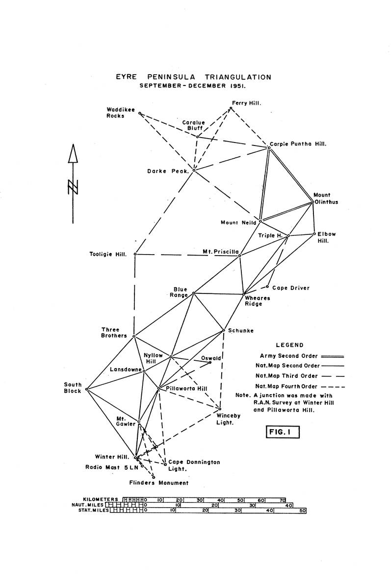
This was the first actual triangulation survey completed by the National Mapping Section. See Figure 1. During 1951 two survey parties, each of five persons divided into two sub-parties, were operating on the Northern Territory. Their task was an astronomical observation program, barometric heighting and field photo identification for the control of the 4 miles to 1 inch map series.
In September with one party operating some 250 miles to the north east of Alice Springs, and the other nearly the same distance to the south west, they received a telegram to return to Alice Springs, and then proceed together to Port Augusta for other duties. Amid great speculation about the nature of these duties the survey party proceeded south. They met the Chief Topographic Surveyor who was accompanied by J.D. Lines, Senior Draughtsman, at Port Augusta.
The new task was now revealed. To carry a second order triangulation chain from the most southern stations of the Royal Australian Army Survey Corps triangulation chain (midway down Eyre Peninsula), to the Port Lincoln area. Here it was to junction with stations established by Royal Australian Navy in that area for horizontal and vertical control during re‑charting the adjacent waters.
A base for accommodation was made at the coastal village of Arno Bay. From here the reconnaissance was carried out by the Chief Topographic Surveyor assisted by the Senior Draftsman, while the beaconing, station marking end clearing was done by the two Northern Territory survey parties under D.R. Hocking. Prefabricated oregon quadrupod beacons, twenty feet high with three feet diameter circular steel vanes, were erected. The reconnaissance, clearing and beaconing was completed in just over a fortnight; in all 18 beacons were erected one of which is shown in Figure 2.
Carrying beaconing material up hill. clearing and building beacons was a new experience for all and the Chief Surveyor truly remarked, “You are armchair surveyors no longer” – a reference to the fact that no hill climbing or long walking trips, were required while on astronomical observations.
One of the first, points to be beaconed was Mt Olinthus, a solid little climb of 25to 30 minutes with the heavy twenty feet long oregon beacon legs. Hill climbing with the beaconing material was a new experience and this was to be the first lesson in the necessity for carrying equipment such as “Yukon” packs, so that hand and shoulder loads could be dispensed with wherever possible. Clearing presented little difficulty – mostly low mallee scrub which is easy to cut, plus some low acacia and other shrubs.
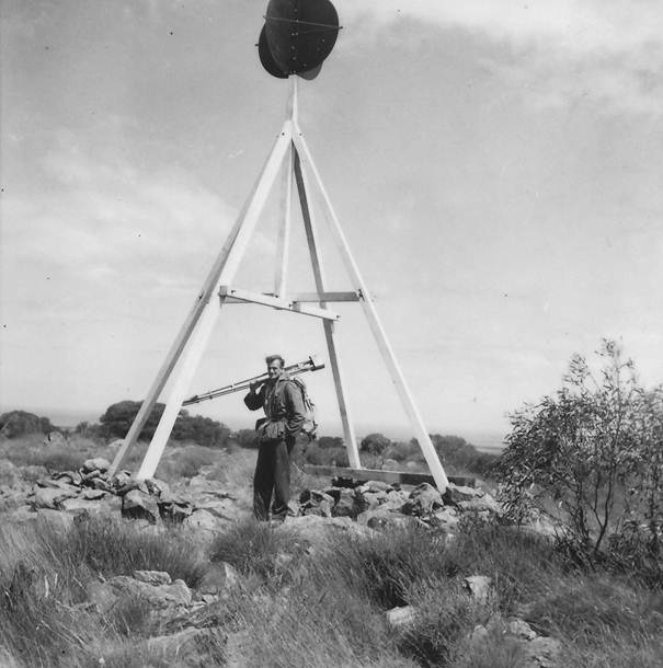
Figure 2: Oregon quadrupod beacon of the type used on the Eyre Peninsula and Bass Strait Surveys with D.R. (Dave) Hocking.
On the completion of the beaconing, a one evening demonstration of theodolite observing techniques was given by the Chief Surveyor who then returned to Melbourne leaving the survey party in charge of J.D. Lines. Apart from this demonstration no other opportunity for practise was available before the observing program began in earnest, thus all had to learn “the hard way”.
Observing commenced early in October; the observers were D.R. Hocking, P.H. Lennie and R.A. Ford. It was unfortunate that E.J. Caspers had to return to Melbourne at this stage, leaving only three observing parties available. This observing can be said to be National Mapping’s first operation in the Geodetic Survey of Australia. True, the scheme was only second order but a nucleus of experienced personnel was being formed around which the future field parties and the survey computation staff would be built.
The Wild T2 theodolites of the astro parties were used and observations were initially to the beacon vanes in the dusk. Considerable difficulty in sighting these targets was experienced due to the poor weather conditions prevailing during that spring on Eyre Peninsula. Constant strong winds, low cloud and rain caused many delays; to speed up observations Lucas Lamps after dark were introduced, and these certainly helped particularly on the longer lines.
During this time all observers were learning and hind sight shows just how much had to be learnt. They were told that the overall spread between rounds in a set of horizontal angles should be within 5" to be acceptable; however with the standard of the training of the observers at that time, and the difficult observing conditions this was rarely achieved. It is now realised that the observers were attempting to obtain a quality in their observations probably beyond that which could be expected under the circumstances. In attempting this they were neglecting to get a sufficient quantity of the best pointings possible under current conditions.
One of the most interesting aspects of the work was the closing of the triangles when the observers met daily to cheek their results. The final overall triangular misclosure averaged 2.3" per triangle; a check azimuth at Winter Hill one of the southern stations, indicated when the computations had been completed that the azimuth had been held to within 5".
Vertical angles were done at previously arranged times so as to be simultaneous reciprocal observations. A level connection was made from a bench mark near Port Lincoln to the station mark on Winter Hill. The difference carrying the heights by vertical angles from the trigonometrical heights of the Army stations, Mt Olinthus and Mt Neild to the levelled height at Winter Hill was about 6 feet.
As the observation of this scheme drew to a close the strong winds which had been prevalent increased to gale force. Considerable damage to telephone lines, windmills etc was done and some steel telephone poles were badly bent. The newly erected survey beacons on Mt Priscilla and South Block were destroyed in this dust and wind storm which reduced visibility to a few yards. This storm was the worst of many experienced during September and October.
While the observing was in progress the parties received a visit from the Director, B.P. Lambert. He had come to do a reconnaissance to the north west of Eyre Peninsula in order to provide some horizontal control for geophysical and geological studies which were to be undertaken by the Bureau of Mineral resources in that area. This reconnaissance indicated that old South Australian Lands Department stations on Darke Peak (shown in Figure 3) and Caralue Bluff would need to be connected to the Army triangulation stations Mt Neild and Carpie Puntha and then two fourth order stations established at Waddikee Rooks and Ferry Hill for the control required by the Bureau.
Darke Peak, Caralue Bluff and Carpie Puntha were all sharp, steep climbs of some thirty minutes so it was back to mountain climbing again for the observing parties; observations were all to lights as no beacons were available. This made for a fairly slow observing programme with only three observing parties plus an occasional person to show a light as shown in Figure 4. Work could only be completed triangle by triangle. This scheme was completed early in December and the field parties returned to Melbourne.
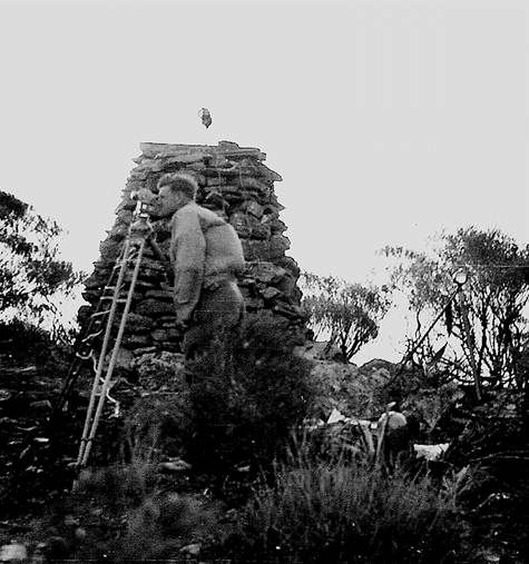
Figure 3: Original SA Lands Department survey cairn Darke Peak - still in perfect condition in 1951.
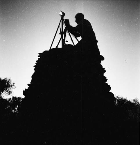
Figure 4: Setting light on top of Darke Peak cairn - photograph taken at dusk.
Summary of field operations
All personnel on the survey enjoyed the type of work involved; they learnt a lot (probably the greatest lesson was just that there was a lot to learn to develop satisfactory techniques). Two other important lessons were that more sets of horizontal angles were required and that both opaque beacons and lights had their place in this type of work.
Survey computations
The chain was adjusted figure by figure by the least squares method. Then provisional geographic and rectangular coordinates of all stations were computed by logarithms. This was a fairly slow process, but at that time was a part of the job to be completed by the observing teams before further field tasks were undertaken.
At that stage no attempt was made to bring the National Mapping results into harmony with the R.A.N figures for Pillaworta Hill and Winter Hill. Only provisional values would be available until the complete loop around Spencer Gulf was recomputed as a whole.
Field Party, 1951
G.R.L. Rimington |
Chief Topographic Surveyor |
J.D. Lines |
Senior Draftsman |
D.R. Hocking |
Surveyor Grade 2 (acting) |
E.J. Caspers |
Field Assistant (Survey) |
F.H. Lennie |
Field Assistant (Survey) |
R.A. Ford |
Field Assistant (Survey) |
R.G. Foster |
Draftsman (Photogrammetric) |
L. Hay |
Cadet Draftsman (Canberra) |
J. Carrucan |
Field Assistant |
W.J. Dingeldei |
Field Assistant |
J. Jaggers |
Field Assistant |
F.J. McCoy |
Field Assistant |