Uluru - Ayers Rock Geodetic Trigonometrical Station – its 1970 remonumenting
Background
By 1958 National Mapping had taken the Geodetic Survey of Australia from the vicinity of Broken Hill, New South Wales, north through South Australia and was extending this survey west along the South Australia-Northern Territory border. In this region, the heights of the Musgrave, Mann and Tomkinson Ranges provided suitable sites for the trigonometrical stations of the first order geodetic network. Occupying stations in the Musgrave Ranges, on the northern horizon could be seen three of the most iconic sights in Australia; from east to west Mount Conner, Ayers Rock now Uluru, and The Olgas now Kata Tjuta. These three locations were thus included in the network as shown in the figure below.
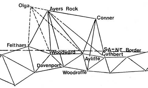
Natmap’s 1958 Geodetic Survey trigonometrical network in the Ayers Rock region (after Ford, 1979).
The dashed lines to station Olga showed that this station was only intersected from the other stations and not occupied for observations.
In recording Natmap’s activities on this section of the 1958 trigonometric survey, Ford (1979) simply stated that : the party had the pleasure of establishing the station mark on Ayers Rock and building our normal cairn with pole and vanes. This was replaced with the current Direction Plaque in 1970.
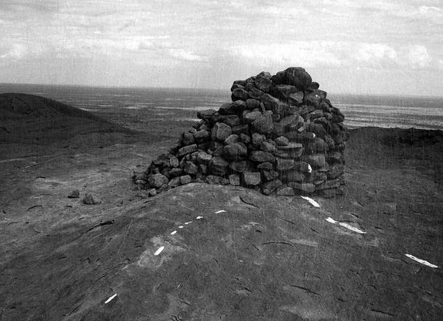
Little else was known about the remonumenting of the Ayers Rock trig station in 1970, although photographs provided by August Jenny and Oystein Berg, Aerodist ground marking fieldwork 1969, and Laurie Mclean, Aerodist line measuring fieldwork 1970, showed the 1958 cairn to be in a dilapidated state at that time. It was believed that the growing pressure of tourism, with the cairn being used as a vantage point for photographs, had been the primary cause for the cairn’s collapse. Please refer to photographs below.
|
|
|
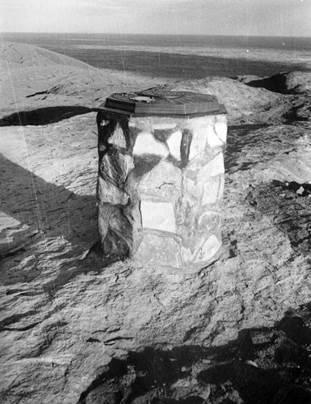
Cairn marking the Ayers Rock geodetic trigonometrical station at Thursday 4 December 1969 (Photo by Natmap’s HA Johnson, NAA: A1575, NM70/57) |
|
|
|
Cairn marking the Ayers Rock geodetic trigonometrical station circa mid 1960s (XNATMAP image) |
|
|
|
Cairn in September 1970 (Courtesy Laurie McLean) |
The Remonumentation of Natmap’s Trig at Ayers Rock
From archived documents it is now apparent that Natmap’s own HA Bill Johnson was the driving force behind replacing the cairn with a more permanent monument. In a January 1970 internal Minute to Natmap’s then Director BP Bruce Lambert Johnson stated that : Last December [1969] in Leonora, I heard from civilian sources that the cairn, erected by National Mapping in 1957 (sic) on Ayers Rock, had collapsed. Accordingly, I inspected it when passing, a few days later and found it an untidy heap of rocks, ill-befitting, such a site, which is visited by thousands of tourists yearly, including many international visitors, and more especially in view of the special permission we were given initially to erect the cairn. Another cairn, unless completely cemented together would suffer the same fate, from those who must climb on them - and carrying the sand, water and cement to cover it would be no small task. It seemed that a direction plate, set on a four foot high pedestal would be a more useful and fitting mark, neither cluttering the area nor breaking the panorama, whose very magnitude is its most striking aspect. At present there is a well-used visitor’s book in a tin container lying on the cairn, and provision should be made to put this in a recess in the pedestal. After speaking on the telephone with you, I discussed the removal of the present collapsed cairn with Mr WT Hare of the NT Reserves Board on 9 December 1969, in Alice Springs, and its replacement by a pedestal and direction plate. He was very pleased with the idea, and subsequently passed it on to the Chairman, who was absent when I called. The cost of the curved bronze plaque for the Johnston Memorial was $116, so this plate and the recess box should not cost more than $200…. It is suggested that the column and plate be centred exactly over our ground mark, so that it may bear an inscription on some part of its face that it is a station established by the Division of National Mapping, Department of National Development, in the National Survey of Australia.
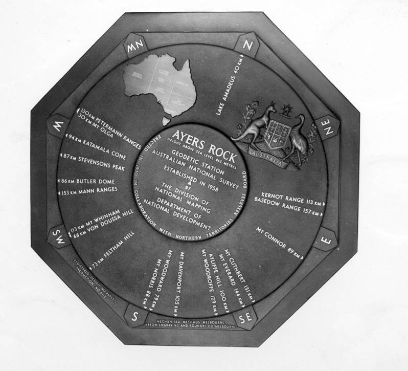
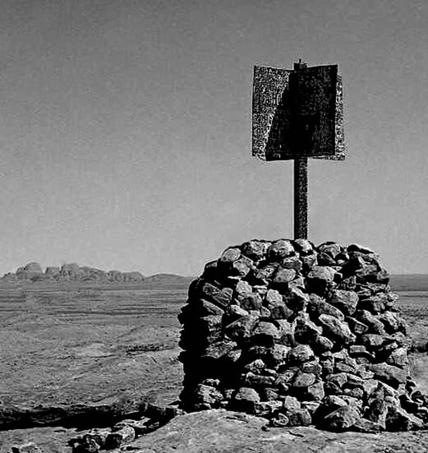
Direction plaque of 0.66 metre (2 feet) diameter, at Natmap’s Collins Street, Melbourne, offices after manufacture (XNATMAP image).
The matter of replacing Natmap’s collapsed cairn on Ayers Rock with plaque and pedestal, was taken seriously by the Director. The layout of a Direction Plaque was soon agreed internally by Natmap and accepted by the Northern Territory Reserves Board. By September 1970 the finished plaque and its accessories had been delivered to the Northern Territory Reserves Board offices in Alice Springs. The plaque cost $410 from Mechanised Methods of Bourke Street, Melbourne; 0.66 metres in diameter it weighed 75lbs (34 kilograms). Mechanised Methods was a subsidiary company of the Arrow Engraving and Foundry Company of Tooronga Road, Glen Iris; this firm had cast the plaque for the Johnston Geodetic Station. In addition to the plaque was a footing plate, pipe column and securing flanges plus a brass, vitriclad processed, visitor book holder. The photograph below taken during construction, shows the plaque secured to its pipe support before being hidden by the masonry cladding.
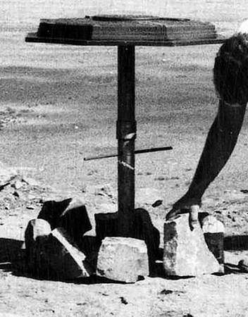
Plaque and support arrangement for the Ayers Rock Geodetic Trigonometrical Station in November 1970.
(Section of photo by Natmap’s HA Johnson, NAA: A1575, NM70/57).
On 3 February 1971, Johnson hand wrote (in his distinctive light blue ink) an internal Minute to the Director. In that Minute Johnson wrote :
|
Mr WT Hare, of the Northern Territory Reserves Board, was told of the progress of the direction plaque in June 1970, and it was delivered to the Board’s Office on its arrival at the end of September, with arrangements made to erect it in late November when most of the tourist stream would be drying up.
On Tuesday 24 November 1970, the original, undisturbed ground and reference marks (all unobtrusive) were located, the remains of the old cairn having been dismantled by the Ranger staff of the Reserves Board on the previous Sunday.
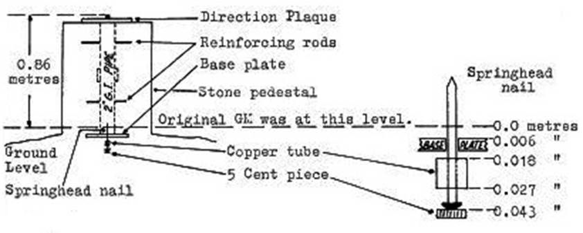
After offsetting, the original small section of ½” diameter copper tube was removed, along with an area of softened, decaying crust, to give a solid flat base for the 7” diameter pedestal footing plate.
Holes were then drilled in this solid rock to take the three Loxons [anchor bolts] holding the plate. The ground mark hole was also deepened into solid rock and a 5 cent coin forced in a tight fit to the bottom, then cementing in a 2” spring head nail upside down to centre the footing, with the original small copper tube forming a collar, as shown in field book NM801 [Fieldbook diagram shown below].
It took all Tuesday to clear the general pedestal area of rock, remove the decaying crust, drill the holes and to erect, centre and orient the pedestal column and plaque exactly over the original ground mark (using close measured offsets and the theodolite for orientation on Mt Olga, the latter fortunately visible each morning before obscured by dust and heat later). However, it was emplaced firmly enough to support without masonry, and with no measurable movement, a young man and woman who were observed early next morning using it as a thoughtfully provided photographic dais.
Reference marks were re-measured, and the difference between the eccentric mark and the original ground mark (24.83 feet in 1958 and 24.75 feet in 1970) was possibly occasioned by a warped Oregon centre pole and the difficulty of centring its top (11 feet high, and to which measurements were made) exactly over the ground mark, doubtless, too in a strong wind as prevalent on Ayers Rock.
The facing was veneered over internal rocks from the old cairn placed around the galvanised 2” pipe pedestal column, with two reinforcing horizontal rods, and all cemented together into one block. Fortunately a thunderstorm on Monday night filled many gnamma holes near the summit with plentiful water for concrete making, drinking and for cooling down generally, in the reverberating heat of midday. At least 20-30 points [of rain] must have fallen near the summit….
When dismantling the old cairn, most of the stone was thrown down an adjacent slope (and this was subsequently carried further down and thrown out of sight, and the slope swept clean of the dangerous, slippery gravel and sand - not without thought and appreciation of the heavy arduous work of Mr RA Ford and his small subparty, who had collected it, barred it off and carried it up that slope to build the initial, neat cairn in 1958). Some stone, however was thrown into a handy gnamma hole, and some other stone and debris used to form a small rock platform close to the monument [from later correspondence, the decision was subsequently made to clean out the gnamma hole of the stone and remove all the loose rock and debris from the vicinity to return the site to its almost original condition].
A point just noticed whilst drafting these letters and collating the photographs is the spelling of Territories in the circular legend Erected in collaboration with Northern Territories Reserves Board – it should be Territory. It was on the diagram sent to Mechanized Methods, despite the repeated checking, and it passed unnoticed apparently even by the Board’s personnel who all seemed to be pleased with this beautiful piece of metallurgical art. |
Members of the 1970 Northern Territory Reserves Board monument construction team (L-R) George Page-Sharpe, Ranger, Ian Cawood, Ranger and 2IC, Derek Roff, Head Ranger, Ian Dawkins and Darrel Toon, both maintenance workers. The men were identified to Marc Hendrickx by Roberta Roff wife of Derek Roff who was head ranger from 1968-1985.
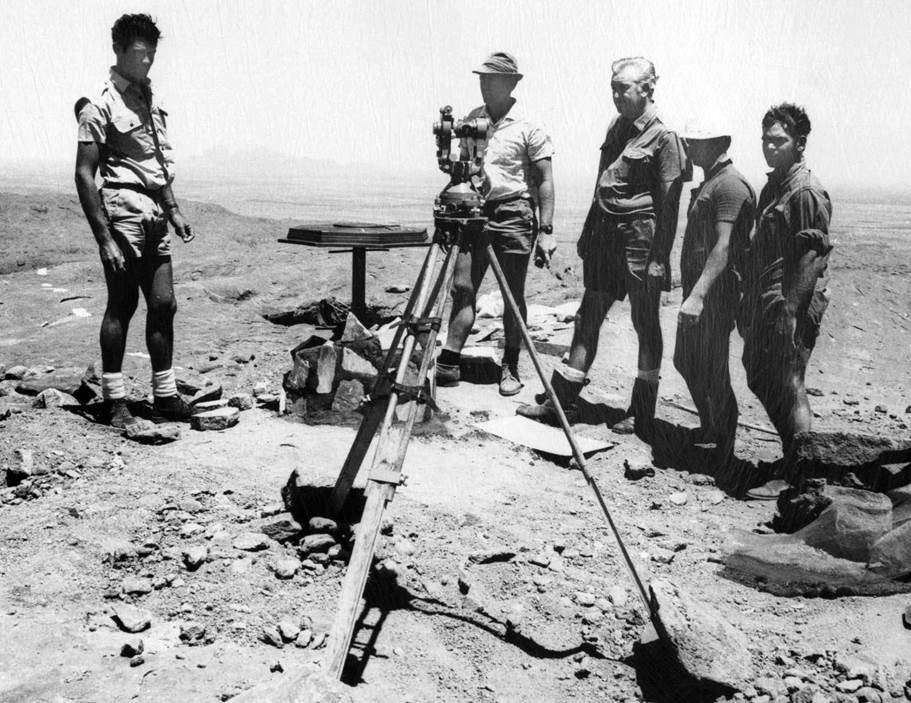
The theodolite is set up over an original reference mark to ensure the accurate positioning, orientation and verticality of the new monument over the station mark.
(Photo by Natmap’s HA Johnson, NAA: A1575, NM70/57).
|
|
|
|
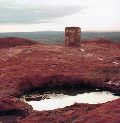
Completed monument November 1970 (Photo by Natmap’s HA Johnson, NAA: A1575, NM70/57). |
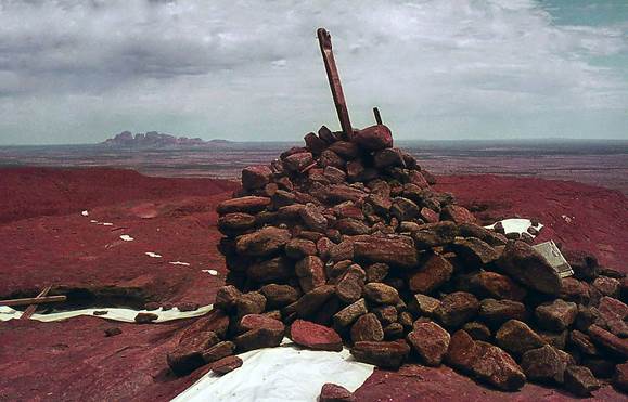
Monument in 1975 after rain (Courtesy Ozcan Ertok).
|
Closing remarks
HA Bill Johnson was Natmap’s only representative during the construction of the new monument in 1970, noting that Johnson was also a member of the Natmap party that built the Johnston Geodetic Station near Kulgera in 1965. Johnson’s role was to undertake the renovation of the original station mark in the rock and ensure that the new monument was centred and vertical over this mark and directionally oriented. Thus the centre of the new monument was sufficiently accurate to retain the first order coordinates of the old trig and no additional survey was required. Further, he was able to provide the precise data to update the applicable National Mapping Council Station Summary. While initially Natmap was prepared to pay for a contractor known to the Northern Territory Reserves Board to perform the construction, the construction work was actually done by Northern Territory Reserves Board staff, as photographed above.
While the veneer of the new monument comprised sandstone, brought from Mount Conner, unseen are the internal rocks all of which came from the old Natmap built cairn. As Johnson said in his minute to the Director above : not without thought and appreciation of the heavy arduous work of Mr RA Ford and his small subparty, who had collected it, barred it off and carried it up that slope to build the initial, neat cairn in 1958.
Finis
In 2019, climbing Uluru was banned, the monument etc removed and Uluru was returned, as best as possible, to its natural state!
Compiled by Paul Wise, 2018, updated 2021.
Acknowledgement
Thanks to Marc Hendrickx for contacting the website and advising that National Archives Australia held an old National Mapping file on the 1970 monumenting at Ayers Rock and National Archives Australia for providing copyright permission to publish images from that file.
Ford, Reginald Arthur (1979), The Division of National Mapping’s Part in the Geodetic Survey of Australia, in The Australian Surveyor, June, September and December 1979: Volume 29, No 6, pp. 375-427; Volume 29, No 7, pp. 465-536; Volume 29, No 8, pp. 581-638, ISSN 00050326, published by the Institution of Surveyors, Australia. This work is accessible on line at: http://www.xnatmap.org/adnm/ops/prog/rafgeosvy/index.htm
Hendrickx, Marc (2018), website email communications.
National Archives Australia (2018), NM70/57, Ayers Rock -
Geodetic Station, Barcode Number: 8241845, Series Number: A1575, Control
Symbol: NM70/57.