Harry William Granger (1928-1977)
National Mapping Senior Surveyor - the Levelling Man
By Laurie McLean May 2019
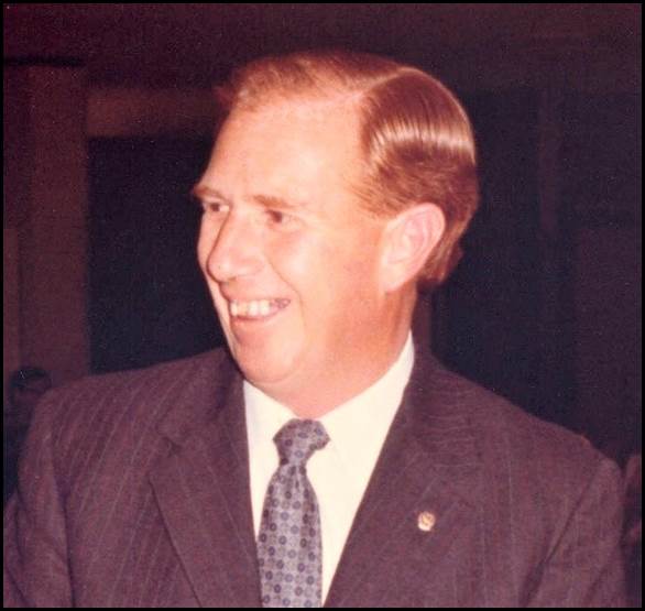
Harry Granger 1975.
Image provided by Barry Sloane.
Harry Granger was a licensed surveyor who worked with the Division of National Mapping from November 1966 until his untimely death in June 1977. All of Harry’s Nat Map service was based from Canberra and was involved with the National Levelling Program and so to that extent he was the levelling man. From 1969 Harry was the senior surveyor in charge of Nat Map’s Precision Levelling Section within the Geodetic Survey Branch. In 1971 this Section together with Adrian Roelse’s Survey Information and Geodetic Analysis Branch undertook the major adjustment of the national levelling network that for the first time provided Australia with an accurate and homogeneous levelling system for mapping and other purposes. The Australian levelling network was one of the largest such systems of levelled heights in the world and in May 1971 it was adopted by the National Mapping Council as the Australian Height Datum.
Harry Granger had many achievements in the field of surveying and gave great service to the survey profession. He made many friends in all walks of life (Anonymous, 1977).
Early life
Harry William Granger was born in Goulburn on 25 June 1928. He was the first of the seven children born to Harry Sheridan Granger (1901-1965) and his wife Lillian Margery Granger née Pidgeon (1904-1991). Harry William’s parents were married in the Burwood registry district of New South Wales in 1927. (On the registry record the bride’s given names were shown as Marjory L.) Harry William’s siblings were his sister Margaret and his brothers Percy George, Wesley Howard, Adrian Sheridan, and Kenneth. Sadly another sister Jennifer Jane died as a two‑month old infant in November 1938.
Harry Sheridan Granger’s parents were George William Granger (circa 1867‑1955) and his wife Ada Margaret Granger née Sheridan (circa 1868‑1949). The Granger and Sheridan families had a number of members in the Collector-Goulburn district. Margery Granger’s parents were Mr and Mrs E W Pidgeon who resided in the inner western Sydney suburb of Strathfield in the 1950s. Strathfield abuts the western side of the suburb of Burwood.
The young Harry William Granger spent his early years on his parents’ grazing property at Rowe's Lagoon about seven kilometres north east of the village of Collector on the Federal Highway between Canberra and Goulburn. Rowe’s Lagoon is a relatively small ephemeral lake with its northern edge abutting the Federal Highway. It is a fraction of the size of Lake George about 15 kilometres to the south west. The Granger family homestead can be seen amongst the pine trees running from the south side of the Federal Highway immediately to the east (right) of Rowe’s Lagoon in the image below.
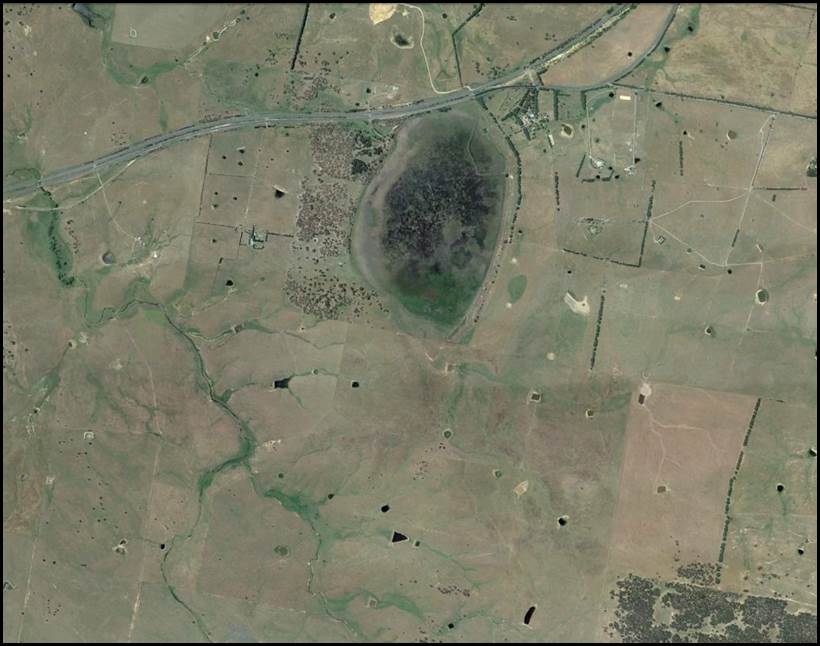
Rowe’s Lagoon near Collector New South Wales.
Google Earth image 24 November 2015.
From electoral roll entries, Harry Sheridan Granger continued as a grazier at Rowe’s Lagoon after the family moved their place of residence to Goulburn. The Rowe’s Lagoon property remained in the Granger family’s possession after Harry Sheridan Granger died in 1965. Also from electoral roll entries Harry William Granger’s third brother Adrian Sheridan Granger (1934-2008) was a grazier at Rowe’s Lagoon from at least 1968 with his wife Noel Joy Granger. In 1968 Adrian Sheridan Granger and Noel Joy Trelford were married in the Burwood registry district in New South Wales. (On electoral rolls between 1958 and 1963 Adrian Granger was listed as a carrier residing at 85 Bradley Street Goulburn.)
The young Harry William Granger received his early schooling on the family property from his mother Margery who was a qualified teacher. By the early 1940s (or earlier) the Granger family had moved their residence into Goulburn about 25 kilometres to the north east of Rowe’s Lagoon. In Goulburn the Grangers resided in a substantial iron-roofed red brick house with a return front verandah at 85 Bradley Street; it was one block north west of the central business district. The house is shown in the image below. A 1980 electoral roll listed Harry William’s mother Margery and his brother Wesley (then a clerk) as still residing at 85 Bradley Street.
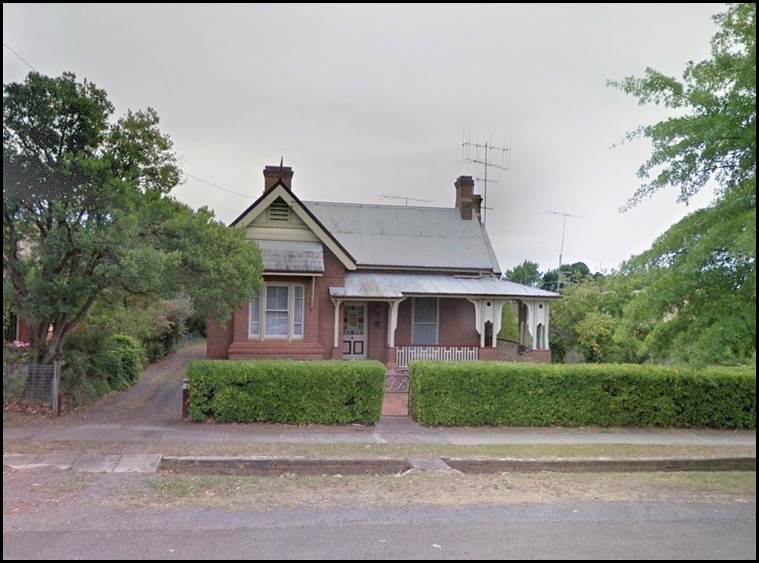
The Granger family home at 85 Bradley Street Goulburn in February 2018.
Google Earth Street View image.
School education to 1946
Harry Granger attended the Goulburn Public School at 204 Bourke Street about 450 metres from his Bradley Street home. This primary school was established in 1868. Afterwards Harry Granger attended Goulburn High School. The High School opened in October 1883 in what was then known as Balmoral House in Citizen Street Goulburn. The present day High School site in Goldsmith Street opened as a new building in 1927 but there have been many subsequent building changes. The High School was about 950 metres from Harry’s home in Bradley Street.
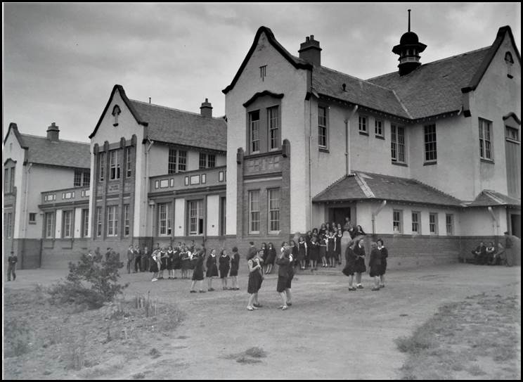
Goulburn High School circa 1946.
New South Wales Department of Education image PF-35.
Harry William Granger obtained the Leaving Certificate in examinations that commenced at Goulburn High School on 12 November 1946. The 1946 examination results were promulgated in the Goulburn Evening Post on 13 January 1947. Harry Granger’s results were consistent; he obtained second‑class passes in all of the five subjects he sat, namely: English, Mathematics, Mathematics II, Physics, and Economics.
Articled surveyor 1947-1956
On 24 March 1947 Harry Granger commenced service with Messrs Fitzgerald and Cochran licensed surveyors of Goulburn. On 17 June 1947 Harry Granger signed an agreement with registered surveyor Edmund Charles Pearce (circa 1909-1985) of Fitzgerald and Cochran to be indentured for four years and to be taught the profession of surveying (Green, 2019).
Surveyor Anthony Barrett Cochran (1904-1980) was born in Lismore New South Wales and was registered by the New South Wales Board of Surveyors under the provisions of section 8 of the Surveyors Act 1929 on 9 November 1931. Anthony Cochran came to Goulburn in 1930 and in 1932 acquired the survey practice of Joseph Edward Fitzgerald who had been registered in November 1929. It is not clear for how long JE Fitzgerald maintained an active role in the practice as by 1942 he was residing at 27 Sutherland Street Auburn. The practice continued to operate as Fitzgerald and Cochran into the 1950s.
After taking over the Goulburn survey practice in 1932 Anthony Cochran enlarged its operations with survey activities extending from Goulburn to the Victorian border (Anonymous, 1942). [Soon after qualifying as a surveyor in May 1932 Herbert Francis Eggling joined Anthony Cochran’s practice at Goulburn. A few years later Bert Eggling joined the then Australian Survey Corps and went on to have a distinguished career there and later with the Snowy Mountains Hydro‑Electricity Authority (Anonymous, 1972).]
In 1940 Anthony Cochran bought out the Cootamundra survey practice of William Underwood Nowland who had been registered in November 1929.
On 13 July 1942 Anthony Cochran enlisted in the Royal Australian Air Force in Melbourne. He served until discharged on 14 November 1945 at which time he was a Flight Lieutenant with No 1 Airfield Construction Squadron RAAF. Cochran’s departure from Goulburn was a loss to the community as he took an active part in the activities of the Chamber of Commerce, Rotary Club and the Rostrum Club as well as being president of the committee of management at Tully Park Golf Club. During Cochran’s absence the practice of Fitzgerald and Cochran was run by Edmund Charles Pearce who had been registered in November 1933 (Anonymous, 1942). Anthony Cochran returned to his Goulburn survey practice after his wartime RAAF service.
On a 1949 electoral roll Harry Granger was listed as an assistant surveyor residing at 85 Bradley Street Goulburn (his parents’ home).
On 21 September 1956 the New South Wales Board of Surveyors issued Harry William Granger with a Certificate of Competency (No 394) (Green, 2019).
On 28 November 1956 Harry Granger was registered by the New South Wales Board of Surveyors under the provisions of the Surveyors Act 1929-1946. At the time his postal address was Post Office Box 115 Cooma. Harry Granger’s subsequent appointment as a mining surveyor by Roger Bede Nott, Minister for Mines, under section 6 of the Mining Act 1906-1952 was promulgated in the Government Gazette of the State of New South Wales on 7 December 1956.
Marriage to Shirley Barnes 1953
A search of the New South Wales Registry of Births, Deaths and Marriages revealed that the marriage of Harry William Granger and Shirley Margaret Barnes was registered in the Teralba registry district in 1953. Teralba is on the north western edge of Lake Macquarie to the south of Newcastle. Harry and Shirley Granger were to have three daughters: Linley Margaret, Deidre Margaret, and Elizabeth Jane.
Living at Cooma 1954-1966
After obtaining his registration as a surveyor in 1956, Harry Granger took over a survey practice in Cooma. Over the next decade he undertook numerous surveys in and around Cooma, the Monaro district and in the Snowy Mountains (Anonymous 1977). Harry Granger’s work from Cooma included power transmission line surveys for the New South Wales Electricity Authority (Johnston, 2019).
On a 1954 electoral roll Harry Granger’s wife Shirley resided at 25 Soho Street Cooma where she was occupied as a clerk. On another 1954 electoral roll Harry Granger was listed as an assistant surveyor residing at 85 Bradley Street Goulburn. However, this entry is likely to have been an oversight as he was most probably residing at Cooma with his wife.
On a 1958 electoral roll Harry and Shirley Granger resided at 9 Adina Street Cooma and were respectively occupied as a surveyor and in home duties. A 1963 electoral roll indicated Harry and Shirley had moved to 8 Baron Street Cooma with same occupations.
In the early 1960s while working in Cooma, Harry Granger employed John Woodger (1936‑2009) as a chainman. [From late 1966, Woody worked as a technical officer with Nat Map’s Canberra-based Precision Levelling Section (Willington, 2019). In 1973 Woody was promoted to technical officer grade 2 (science) in the Positional Astronomy Section that operated initially from the Mt Stromlo Observatory and later from the newly established Orroral Geodetic Observatory in the Namadgi National Park about 60 kilometres south of Canberra. Later Woody worked with the precise caesium clocks for the national time service with John Luck and other Nat Mappers (Manning, 2019). In November 1998 the Orroral Observatory was closed and some of its functions transferred to a newly built facility at Mt Stromlo about 12 kilometres west of Canberra’s city centre. John Robert Woodger retired as a senior technical officer (level 4) in January 1999 and sadly died in Canberra on 21 March 2009 after a long illness; he was 73 years of age.]
During his time at Cooma, Harry Granger pursued his interest in aviation and qualified for his Private Pilot Licence (Sloane, 2019). Harry continued flying for private and recreational purposes while later living in Canberra (Willington, 2019).
National Mapping Canberra 1966-1977
Harry Granger joined the Division of National Mapping in the Department of National Development in Canberra in November 1966 (Anonymous, 1977). As was often the case for many Nat Map field-oriented staff, Harry’s appointment as a surveyor class 1 (Third Division) was not promulgated until some time after he had commenced duty with Nat Map. In this case the promulgation was in the Commonwealth of Australia Gazette on 12 October 1967.
As further outlined in Appendix A, in 1962 under the auspices of the National Mapping Council, Nat Map commenced an accelerated national program of control levelling surveys in collaboration with State mapping authorities. In 1966 Nat Map established a Precision Levelling Section in the Geodetic Survey Branch in Canberra with responsibility for the Division’s involvement with this national program; further details of this Section are provided in Appendix B.
Harry Granger’s recruitment into Nat Map’s Precision Levelling Section had been arranged by Klaus Leppert (1925-1995) (Murphy, 2019). Klaus had joined Nat Map from the Snowy Mountains Hydro-Electricity Authority in 1961. In July 1966 Klaus Leppert was promoted to a newly created senior surveyor position in charge of the Precision Levelling Section in the Geodetic Survey Branch in Canberra.
Harry Granger’s position as a surveyor class 1 in the Precision Levelling Section involved extensive periods of field survey duty, particularly during the period from April to November each year when weather conditions were generally more favourable for field survey work. During his decade or so in the Section Harry was in charge of many levelling and tide gauge surveys covering all States of Australia (Anonymous, 1977).
An indication of the scope of the field work that Harry Granger undertook during his early years in the Precision Levelling Section was given in the 1968 Field Season Instructions that Klaus Leppert issued to him on 26 April 1968. A copy of these instructions (with minor formatting changes) is provided at Appendix C.
The Precision Levelling Section’s 1969 field survey work was in the Northern Territory west of the Stuart Highway, between Robinson River and Wollogorang (on National Route 1 in the Gulf of Carpentaria area of the Northern Territory), and in Western Australia. That year Harry Granger rotated periods of field party leadership with Peter O’Donnell who was then a surveyor class 1 (Wise, 2014).
From copies of permanent bench mark records in Division of National Mapping Technical Report 12 The Adjustment of the Australian Levelling Survey 1970‑1971 it is apparent that Harry Granger covered a fair amount of Australia during his time as field party leader in 1969. For example, around 22 April 1969, Harry supervised technical officer Fred Reardon’s establishment of a cluster of three reference bench marks (including bench mark NMV/G/14) near the Johnston Geodetic Station in the far south of the Northern Territory. Around 19 May 1969 Harry Granger was at Wyndham in the East Kimberley region of Western Australia where he supervised Fred Reardon’s establishment of bench mark NMV/F/11 on the Wyndham wharf (Roelse et al, 1971).
In early December 1969, Klaus Leppert was promoted to the position of supervising surveyor in charge of Nat Map’s Geodetic Survey Branch. The main field survey component of that Branch was relocated from Melbourne to Canberra after the conclusion of the 1969 field survey season.
In early December 1969 Harry Granger replaced Klaus Leppert as senior surveyor in charge of the Precision Levelling Section. Harry’s promotion to the position of surveyor class 2 (Third Division) in the Precision Levelling Section of the Geodetic Survey Branch, Canberra was promulgated in the Commonwealth of Australia Gazette on 4 December 1969.
As senior surveyor, Harry Granger’s overall duties were to plan and direct the activities of the Precision Levelling Section. He was also responsible for reviewing progress and making recommendations in regard to the national program of control levelling surveys. Harry also had to arrange contracts with private surveyors for levelling, both directly and through State Lands Departments.
Nat Map’s Precision Levelling Section together with the Survey Information and Geodetic Analysis Branch undertook the major adjustment of the Australian levelling network. This adjustment resulted in the Australian Height Datum being adopted by the National Mapping Council at its 29th meeting that was held in Canberra during 4-6 May 1971. In June 1971 the Division of National Mapping published Technical Report 12 Adjustment of the Australian Height Datum. That report reviewed the history of the Australian National Levelling Survey and described the technical and mathematical procedures used in its adjustment. The report was prepared by Harry Granger together with fellow Nat Mappers Adrian Roelse (Survey Information and Geodetic Analysis Branch) and John Graham (Precision Levelling Section). A link to the report is provided at Roelse et al, (1971) in the References below.
In December 1972 Harry Granger’s 10-page paper The Australian height datum was published in The Australian Surveyor. The paper provided a general description of the Australian levelling network and its adjustment.
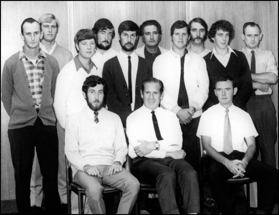
Nat Map’s Precision Levelling Section circa 1972.
Standing left to right: John McPhie, Adrian Ferguson, Ian Green, John Dickson, Rod Craven, John Birrell, Dick Mooney, Ken Byrne, Bob Cameron, and Jack Lamb.
Seated left to right: John Graham, Harry Granger, and Barry Sloane.
XNatmap image.
Living in Canberra
On a 1968 electoral roll Harry and Shirley Granger resided at 13 Ogilvie Place Garran in the Woden Valley on Canberra’s south side. Apparently the Grangers later moved a few doors down the hill in Ogilvie Place. Electoral rolls for 1972 and 1980 listed the Granger family as residing at 1 Ogilvie Place Garran.
Public and professional activities
Harry Granger was very active in public life mainly through his involvement in Rotary Clubs at Goulburn, Cooma (that was chartered in 1954) and in Canberra. During Harry’s seven years with the Rotary Club of Woden he served in many offices including as community service director, sergeant-at-arms, branch vice‑president and as the (seventh) branch president from June 1975 to June 1976. Harry was also active in professional bodies. He was Honorary Secretary of the Institution of Surveyors of Australia, Canberra Division from early 1975 until his untimely death. Harry was president of the National Mapping Group (Canberra) of the Professional Officers Association (Anonymous, 1977).
Vale
On Tuesday 21 June 1977 Harry Granger was at Jervis Bay undertaking surveying and maintenance work at the tide gauge on the wharf at the Royal Australian Navy base HMAS Creswell. Sadly at around 2:30 in the afternoon Harry suddenly collapsed on the wharf. He was immediately assisted by fellow Nat Map senior surveyor Barry Sloane while technical officer Andy Rodgers ran to a nearby Navy workshop to call an ambulance. After first aid treatment Harry was conveyed by Navy ambulance to the Shoalhaven District Memorial Hospital in Nowra about 20 miles to the north where he was pronounced dead on arrival. Harry Granger had died from a heart attack; he was 48 years of age and just four days short of his 49th birthday.
Harry Granger was survived by Shirley his wife of some 24 years and by their three daughters Linley, Deidre, and Elizabeth. Harry was also survived by his mother Margery and by siblings Margaret, Percy, Wesley, Adrian and Kenneth.
Harry Granger’s funeral service was held on 24 June 1977 at the Good Shepherd Anglican Church, 157 Carruthers Street Curtin. The service commenced at 10:30 am. Afterwards Harry Granger’s remains were privately cremated at the Norwood Park Crematorium in the northern Canberra suburb of Mitchell. Harry’s funeral arrangements were undertaken by Canberra Funeral Directors of Kingston.
Later Harry’s ashes were interred at the Granger family private cemetery on their Rowe’s Lagoon property. The ashes of his sister Jennifer Jane and of his father Harry Sheridan had been interred there in 1938 and 1965, respectively. The ashes of some other members of the Granger family were interred at the Rowe’s Lagoon family cemetery after Harry William’s death, namely those of his nephew Andrew John Granger in 1988, his mother Lillian Margery in 1991, and his brother Adrian Sheridan in 2008.
In 2011 the memorials and ashes of all of the above‑mentioned Granger family members were relocated from the Rowe’s Lagoon family cemetery to Grave 108 in the Anglican Cemetery at Collector (Challinor, 1996 with later updates). The remains or ashes of various other members of the Granger and Sheridan families are also interred at the Collector Anglican Cemetery.
Memorial plaque near the Orroral Observatory
A few months after Harry Granger’s death a memorial plaque for him was placed near the the Orroral Astro Geodetic Observatory. The plaque was placed by Nat Map technical officer Andy Rodgers and was fixed to the steel encased reinforced concrete pillar at survey control station NM/C/106 about 23 metres south east of the Observatory.
The plaque was inscribed: Harry Granger Surveyor National Mapping 25-6-28 21-6-77. An image of the NM/C/106 pillar and the plaque is shown in the image below.
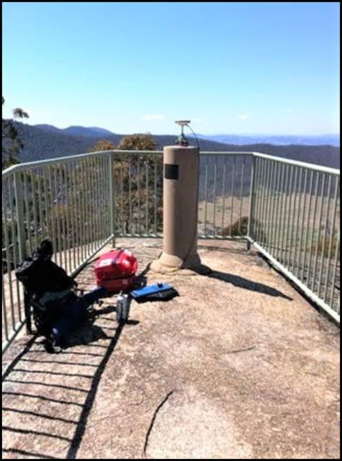
Survey station NM/C/106 pillar at the Orroral Observatory.
ACT Heritage Council image 2015.
Nat Map’s Orroral Observatory was established in 1974-1975 under the terms of an October 1968 agreement signed between Australia and the the United States for scientific and technical co-operation. This agreement was named the Hornig Treaty for Dr Donald Frederick Hornig (1920-2013) an American chemist, explosives expert, teacher and science advisor to president John Fitzgerald Kennedy. In March 1973 an agreement under the Hornig Treaty was signed between the Division of National Mapping and the United States National Aeronautics and Space Administration for co-operation on the construction of a lunar laser ranging facility in the Orroral Valley in the Namadgi National Park about 60 kilometres south of Canberra.
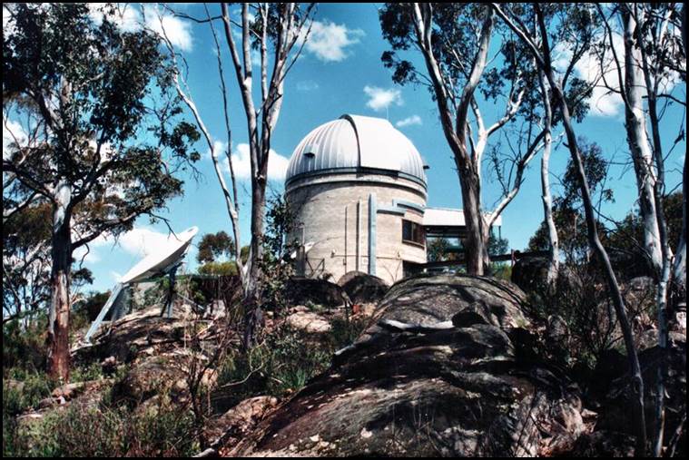
Nat Map’s Orroral Observatory in the 1980s.
XNatmap image from Dave Abreu.
In 1975, the Orroral Observatory saw the beginning of Nat Map’s lunar (and the later satellite) laser ranging program. This program commenced Nat Map’s use of laser ranging to measure distances from the Earth to the Moon and later to orbiting artificial satellites. Laser ranging enabled calculations to be made on the changing shape of the Earth as well as monitoring changes in the Earth's rotation and the movement of tectonic plates (continental drift).
From the early 1970s Nat Map coordinated and disseminated the precise Australian national time scale; initially from Mount Stromlo. In October 1974. three caesium atomic clocks from Mount Stromlo were installed at the Orroral Observatory and the national time service then operated from that location. From 1977 the ensemble at Orroral comprised four caesium atomic clocks and three rubidium clocks. One clock was designated as the national primary standard of time and was maintained to keep Australian time accurate to 100 nanoseconds. Another caesium clock was portable and was used for national and international time transfers and to support Nat Map field survey operations.
During the mid-1970s, Nat Map’s Geodetic Survey Section undertook considerable survey work to establish a Lunar Laser Ranger control network as well as check surveys to monitor vertical movement of the Lunar Laser Ranger.
Harry Granger’s Geodetic Levelling Section also undertook considerable levelling work for the lunar laser ranger and other observatories in the Australian Capital Territory. For example, during calendar 1975, levelling connections were made to 14 trigonometrical stations in the Australian Capital Territory and to the Tidbinbilla, Honeysuckle Creek and Orroral tracking stations also work continued on the Orroral Valley Vertical Control Network. That year Nat Map’s levelling activities in the Australian Capital Territory involved the establishment of 14 bench marks, 57 kilometres of one-way check levelling, 160 kilometres of two‑way third order levelling and 80 kilometres of first order levelling.
Satellite laser ranging ceased at Orroral in October 1998 and some of the equipment was transferred to a new automated facility at Mount Stromlo.
Acknowledgements
During the research and preparation of this article the following people generously provided assistance:
· Ken Green, co-ordinator of Surveying New South Wales - The Pathfinders, Seniors Group of Surveyors, the Institution of Surveyors, New South Wales, Incorporated
· Fran O’Flynn, Local Studies Officer at Goulburn Mulwaree Council
· Phil Allen, former National Mapping technical officer
· John Manning PSM, former National Mapping assistant director
· Brian Murphy, former National Mapping senior surveyor
· Peter O’Donnell, former National Mapping assistant director
· Barry Sloane, former National Mapping senior surveyor
· Andy Rodgers, former National Mapping technical officer
· Bruce Willington, former National Mapping supervising surveyor
· Paul Wise OAM, founder, operator, and editor-in-chief of the XNatmap website.
The author gratefully acknowledges the kind assistance provided by these people.
National Levelling Program 1962-1970
Under the Petroleum Research Subsidy Act 1959 Nat Map had obtained funding to advance the national levelling program using private sector contractors (Lines 1992). Nat Map’s initial assistant director Lindsay Rimington (1908‑1992) led the Division’s resultant national levelling program under the auspices of the National Mapping Council. In conjunction with the State Surveyors General, Rimington selected the routes for the levelling traverses. Rimington continued to head this program until his retirement in 1968. But from 1966 the hands on responsibility was taken by a specially created Precision Levelling Section in the Geodetic Branch as further outlined in Appendix B.
Bruce Lambert the then Director of National Mapping had opted for a national control levelling network to third order standard after giving due consideration to economy, efficiency and the degree of precision needed for national mapping purposes. Lambert recognised that national control levelling to higher standards would take many more years to complete, would involve the placing of many more permanent bench marks and be several times more expensive. Lambert also recognised that disturbances and movements in the Earth’s crust over time would impact more on a high precision levelling network such that it could involve a perpetual need for re-observations (Lambert, 1989).
Prior to 1956, about 3 000 miles of control levelling had been completed in three of the six states of the Commonwealth. Between 1956 and 1960 an additional 10 000 miles were levelled and by the end of 1966 the total amount of control levelling had reached some 76 000 miles and covered the whole of the continent (Leppert, 1967). At the end of 1970, some 100 900 miles of control levelling had been completed (Roelse et al, 1971). The National Levelling Network at the end of 1970 is shown in Figure A1 below.
As mentioned above, in 1962 Lindsay Rimington had commenced the accelerated national program of control levelling surveys. For this major national program Rimington and his fellow Nat Map officers worked in cooperation with the various State Lands Departments. The resulting levelling surveys and associated tide gauge observations were used to determine the Australian Height Datum that was adopted by the National Mapping Council in May 1971 (McLean, 2019). From the overall National Levelling Network of over 100 000 miles of levelling, some 60 472 miles of Primary Levelling contributed to the determination of the Australian Height Datum. The other 40,000 miles of levelling was termed Supplementary Levelling but this term was not a reflection on its quality (Roelse et al, 1971).
The Australian Height Datum 1971 was the datum surface derived from the simultaneous adjustment of the two way levelling network holding 30 tide gauges fixed at their mean sea level values (Roelse et al, 1971).
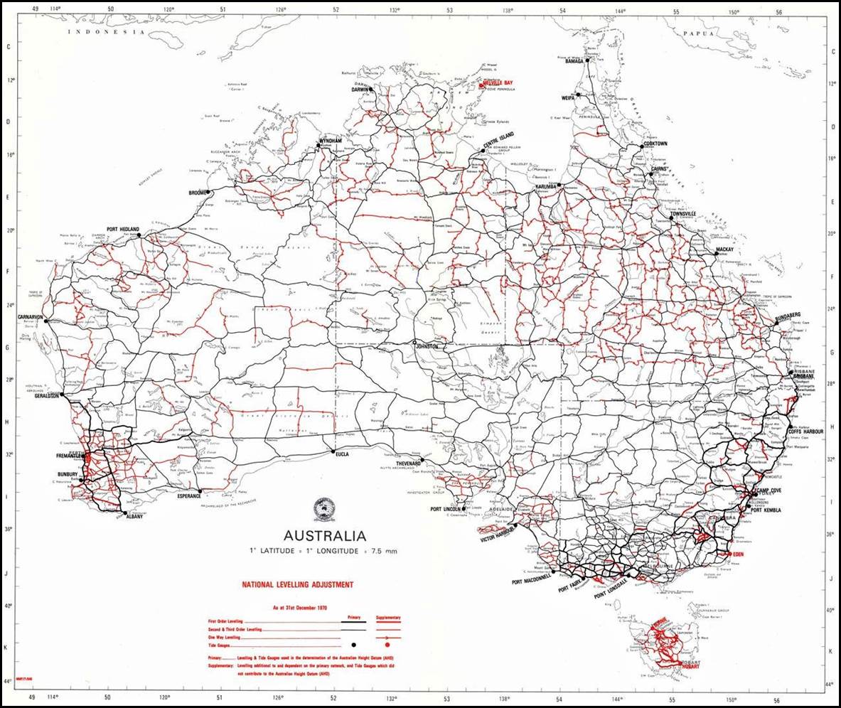
Figure A1: The National Levelling Network at 31 December 1970.
First and lower order primary levelling is depicted in black and supplementary levelling is depicted in red. Source: Wise, 2014.
Nat Map’s Precision Levelling Section
In 1966 a Precision Levelling Section was established within the Geodetic Survey Branch of the Division of National Mapping. The Section’s functions were to:
· Make precise differential levelling surveys and undertake work required to complete the Australian levelling network for which contract levelling is not available; check the work of contractors; and connect the Australian levelling network to geodetic stations on the Australian Geodetic Datum
· Arrange and supervise levelling surveys by contractors and directly and through the Surveyors General of the States and Territories, examine and recommend payment of accounts
· Arrange and supervise observations at tide gauges and the computation of tide gauge readings by contractors
· Determine and periodically review mathematical models of the earth and compute and adjust all levelling surveys to produce an homogeneous series of heighted points over Australia on which mapping and other surveys can be based
· Investigate new methods of levelling and computation
· Make recommendations for, and assist in the drafting of national specifications and recommend practices for geodetic levelling (Roelse et al 1971).
Between 1966 and 1971, Nat Map’s Precision Levelling Section’s field activity in the national levelling network was mainly confined to areas where because of access difficulties and remoteness private surveyors could not be expected to operate; to the completion of border connections; and to check levelling and inspection.
In all between 1966 and 1971, 389 sections totalling 3 851 miles were check levelled and the marks on 1 717 miles of traverses were inspected following reports of sub-standard marking. A large number of level books were examined, in some cases as an investigation of excessive discrepancies between forward and backward runs, and in others following suspected malpractice and non‑compliance with specifications.
As a result of these investigations some 660 bench marks were replaced or improved by the contractors responsible for their original installation. Some contractors were required to carry out complete re-levelling and payment to others was withheld (Roelse et al 1971).
DEPARTMENT OF NATIONAL DEVELOPMENT.
MINUTE. NM: 68/170
Subject: LEVELLING SECTION GEODETIC BRANCH 1968 FIELD SEASON, INSTRUCTIONS
Mr Granger Field Party Leader
Mr Reardon Sub-Party Leader
Mr Whalen Sub-Party Leader
Mr Woodger Sub-Party Leader
General This year's field activity will take place in Queensland north of latitude 24º and in the Northern Territory east of the Stuart Highway.
Object The object of the field work is to:
connect selected trigonometric, traverse and Aerodist stations and one Hiran station to the National Levelling Network;
identify the exact location of permanent bench marks or nearby easily identifiable points on aerial photographs;
check level between permanent bench marks of hitherto unchecked Third Order Contract Levelling work;
provide levelling connections between traverses on either side of the Queensland/Northern Territory Border;
provide levelling connections between the three tide gauge bench marks at tide gauge stations and the nearest State bench marks;
establish clusters of 3 Reference Bench Marks at selected localities and connect them to existing permanent bench marks by Third Order Levelling.
Composition of Field Party
Mr H Granger, Surveyor Class 1, will be in charge of the field party which consists of 3 sub-parties as follows:
|
Sub-Party 1 |
Sub-Party 2 |
Sub-Party 3 |
|
Fred Reardon T0 1 |
Mike Whalen T0 1 |
John Woodger T0 1 |
|
Dick Mooney FA |
John Rutherford FA |
Andy Rodgers FA |
|
Ken Byrne FA |
Peter Walkley FA |
Joe Murray FA |
Vehicles
The party will be equipped with 7 International trucks of the C1300 series with the following registration numbers:
ZSU-208, ZSU-209, ZSU-210, ZSU-213, ZSU-214, ZSU-219, ZSU-222.
Administrative Instructions
Please study the Administrative Instructions for Field Parties carefully, paying particular attention to Chapter 2 (Extra Duty Pay), Chapters 7 and 8 (Purchase Orders) Chapter 16 (Use of Official Vehicles) and Chapter 19 (Travelling).
Finance
The party leader has been issued with Finance Requisition NMF 2458 for $1 000.
Communication
(Radio) Call signs on the PMG and WRE Networks are:
|
|
PMG |
WRE |
|
H W Granger |
8 SUI |
BW 123 |
|
F C Reardon |
8 SHA |
BW 203 |
|
M H Whalen |
8 SUG |
BW 206 |
|
J R Woodger |
8 SXR |
BW 128 |
You should arrange a daily radio schedule between yourselves on the National Mapping Radio Frequencies (see Chapter 10 of the Administrative Instructions for Field Parties);
The party leader shall telegraph Natmap Canberra on arrival in Brisbane and on the conclusion of the fieldwork;
The party leader shall telephone me at least once per fortnight preferably on a Monday morning on Canberra 45144 reversing the charges. He is to give a description of the work completed by the whole party and to nominate a Post Office for the forwarding of mail;
Every other week the party leader shall inform me by telegram of the work completed during the week.
Claims Diaries and Field Attendance Records shall be forwarded fortnightly to the Director of National Mapping, Box 667, Canberra City, ACT 2601, Attention Mr Leppert by airmail. They should be based on a fortnight starting on Thursday of an off pay week and finishing on a Wednesday of an off pay week.
Field Work
Details of the field work to be undertaken are contained in the attached Schedule of Technical Instructions.
K LEPPERT
Surveyor Class 2
26/4/1968
(Source for Appendix C: Wise, 2014.)
Schedule of Technical Instructions
The party leader shall call on the:
Surveyor General Queensland when in Brisbane
Surveyor General NT when in Darwin
Supervising Surveyor Alice Springs when in Alice Springs.
Location of Work
The location of survey work to be done is marked on the attached map in various colours. [Map not attached here.] All levelling is to be done in accordance with the Specifications for One-Way Levelling or the Specifications for Two-Way Levelling as required. Marking is to be done in accordance with the Specification for Permanent Marking and the Specification for Establishing of Reference Bench Marks. Bench Marks are to be of type A, B, C, or D.
Level Connections to horizontal control stations are indicated by a red circle. Such stations are to be connected to the National Levelling Network by two‑way levelling to existing permanent bench marks. Levelling between these two existing marks shall be one-way only.
Where the distance measured along the levelling route from the nearest of the two existing permanent bench marks to the horizontal control stations exceeds 4 miles, new permanent bench marks are to be established at intervals not exceeding 4 miles.
At the horizontal control station all reference marks and the station mark shall be levelled. Where the station mark is not accessible (stone cairn) the top of the disc or flag of the beacon shall be levelled.
The relation between the station mark (centre) and the reference marks shall be determined by magnetic bearing to the nearest ½ degree and by distance to the nearest 1/100 ft. All such measurements are to be recorded in the level field book together with a sketch showing the relative position of reference marks and station mark (see sample sketches). Wherever possible distances shall be measured horizontally. Slope distances shall be reduced to horizontal distances.
Before leaving a horizontal control station all disagreements between previous measurements and present measurements have to be resolved.
Horizontal control stations and permanent bench marks for which prints of aerial photographs are provided shall be identified by pricking their position with a fine needle.
Border connections are indicated by a brown circle. Two permanent bench marks on one side of the border shall be connected to two permanent bench marks on the opposite side of the border by two-way levelling.
Tide gauge connections are indicated by a green circle. The three tide gauge bench marks shall be connected to two State bench marks by two-way levelling.
Check levelling at the two Aerodist stations levelled by contract surveyors shall be one-way levelling. The amount of check levelling is to be determined by the party leader.
Clusters of three Reference Bench Marks are indicated by an orange circle. Such clusters shall contain one existing permanent bench mark and two newly established ones. The three marks are to be connected by two-way levelling to each other. The existing mark is to be connected to the nearest other existing mark by one-way levelling. A sketch is to be made showing the relation between the three marks of a cluster and to existing natural or man-made features. Distances to be shown to the nearest foot and magnetic bearings to the nearest ½º).
Photo identification of permanent bench marks along traverses is indicated by a green line. All permanent bench marks along these traverses shall be identified on aerial photographs by pricking their position with a fine needle and annotation on the back of the photograph. Where an identification is in doubt an easily identifiable point nearby shall be levelled and identified by a pinprick. The difference in height between the bench mark and this point shall be written on the back of the photograph (i.e. +17.4 ft from PBM No... or - 19.7 ft from PBM No…).
Check levelling along contract levelling traverses is indicated by a blue line. Randomly selected sections between permanent bench marks constituting about 10% of the whole distance of the traverse shall be check levelled by one-way levelling.
Numbering of yet unnumbered marks in Queensland. Each permanent mark which has been positively identified with the aid of the Permanent Bench Mark Sketch and which is not numbered shall have its identification number punched into the space provided on the bronze plaque.
Permanent Bench Mark Record Cards have to be filled in for newly established marks; existing marks which have been p hoto identified and marks which are found damaged or destroyed.
Record cards for Control Stations (white) and/or Aerodist Stations (orange) have to be filled in when work is carried out at horizontal control stations.
Map Correction Report. Please note all omissions, errors and outdated information pertaining to the 1:250 000 and 1:1 000 000 maps you have been provided with on the Map Correction Forms issued to you.
Checking of Work. Before leaving the immediate area in which levelling work has been carried out a summary of this work shall be completed in all detail and a check made to see that all levelling is of specified accuracy. Summary sheets for this purpose will be supplied.
Photography of Marks. Two black and white photographs shall be taken of each horizontal control station at which work is to be carried out and of each newly established permanent bench mark. One photograph shall be a closeup of the station mark or bench mark and the other shall show the immediate area surrounding the station or bench mark.
Photographs shall also be taken of marks found destroyed, damaged or improperly constructed.
A record of exposures is to be kept on the Film Record sheets provided. It is advisable to make a blank exposure at intervals of about 8 exposures and to register these blanks as such. On completion the film is to be numbered on the wrapping paper and on the cassette.
Bench Mark Identification Numbers. The following numbers have been allotted to you:
|
|
NT |
Queensland |
SA |
|
Mr Granger |
|
|
NMV/E/20 to 25 |
|
Mr Reardon |
NMV/G/1 to 29 |
NMV/B/8 to 99 |
|
|
Mr Woodger |
NMV/G/30 to 59 |
NMV/B/102 to 150 |
|
|
Mr Whalen |
NMV/G/50 to 89 |
NMV/B/151 to 199 |
|
K LEPPERT
Surveyor Class 2
25 4 1968
(Source for Appendix C: Wise, 2014.)
References
Australian Capital Territory Heritage Council (2016), Orroral Geodetic Observatory, Block 88 (part), Tennent, Background Information, an item on the ACT Heritage Register (register by place search); accessed from Environment, Planning and Sustainable Development Directorate – Environment on the ACT Government website at: https://www.environment.act.gov.au/__data/assets/pdf_file/0007/1274830/Updated-Orroral-Geodetic-Observatory-Background-Information.pdf
Allen, Phil (2019), Personal communications.
Anonymous (1942), Mr A Cochran RAAF Service, an article in the Goulburn Evening Post, Wednesday 8 July 1942, page 3; accessed from the National Library of Australia Trove search service at: https://trove.nla.gov.au/newspaper/article/99787251
Anonymous (1947), Results of Leaving Certificate: Goulburn Schools, in the Goulburn Evening Post, Monday 13 January 1947, page 2; accessed from the National Library of Australia Trove search service at: https://trove.nla.gov.au/newspaper/article/103336968
Anonymous (1954), Jottings Round Goulburn and District; in the Goulburn Evening Post, Wednesday 10 February 1954, page 6; accessed from the National Library of Australia Trove search service at: https://trove.nla.gov.au/newspaper/article/103695769
Anonymous (1972), Herbert Frederick Eggling, Personalities of the Profession, an article in the Australian Surveyor Volume 24, Issue 4, December 1972, pages 268-269.
Anonymous (1977), Harry William Granger, Death Notice, in the Goulburn Post 27 June 1977, page 13; copy kindly provided by the Goulburn Mulwaree Library.
Anonymous (1977 A), Granger, Harry, Death and Funeral Notices in The Canberra Times, Family Notices, Thursday 23 June 1977, page 21; accessed from the National Library of Australia Trove search service at: https://trove.nla.gov.au/newspaper/article/110851563
Anonymous (1977 B), Granger (Harry William), Funeral Notice in The Canberra Times, Family Notices, Friday 24 June 1977, page 14; accessed from the National Library of Australia Trove search service at: https://trove.nla.gov.au/newspaper/article/110851714
Anonymous (1977 C), Obituaries Harry William Granger; in The Australian Surveyor, Volume 28, Issue 7, September 1977, page 471; accessed from the XNatmap website at:
http://www.xnatmap.org/adnm/people/aabout/Granger%20HW/Harry%20Granger%20Obituary.htm
Anonymous (undated), List of Inscriptions at Collector Anglican Cemetery, Bourke Street Collector New South Wales 2581; accessed from Australian Graves Index website at: http://austcemindex.com/?cemid=858
Anonymous (2016), Past Presidents of the Rotary Club of Woden; accessed from the Rotary Club of Woden website at: https://sitedesq.sportstg.com/custompage/index.cfm?fuseaction=display_main&CategoryID=13914&OrgID=8118
Australian Electoral Commission (1903-1980), Searches of various historical electoral rolls; accessed from the Ancestry website at: http://search.ancestry.com.au/search/
Barrow, Graeme (1999), Space explorers quit Orroral, an article in National Parks Association Bulletin, Volume 36, No 4, December 1999, pages 8-9; accessed from National Parks Association (ACT) Incorporated website at: https://www.npaact.org.au/res/File/Bulletins2/Vol%2036%20No%204%20Dec%201999%20A.pdf
Board of Surveyors New South Wales (1956), Registration of surveyor Harry William Granger; promulgated in the Government Gazette of the State of New South Wales, Issue No 119, Friday 2 November 1956, page 3197; accessed from the National Library of Australia Trove search service at: https://trove.nla.gov.au/newspaper/article/220347019
Challinor, Graeme (1996 with later updates), The Anglican and Catholic Cemetery at Collector New South Wales, List of Graves; accessed at: https://www.gundaroo.info/genealogy/cemeteries/coll_ac/coll_ac.pdf
Commonwealth of Australia (1967), Appointment of Harry William Granger as surveyor class 1, Department of National Development; promulgated in the Commonwealth of Australia Gazette, Issue No 88, Thursday 12 October 1967, page 5638; accessed from the National Library of Australia Trove search service at: https://trove.nla.gov.au/newspaper/article/241018491
Commonwealth of Australia (1969), Registration of Harry William Granger in List of Surveyors registered in accordance with section 17 of the Surveyors Ordinance 1957; promulgated in the Commonwealth of Australia Gazette, Issue No 28, Thursday 27 March 1969, page 1886; accessed from the National Library of Australia Trove search service at: https://trove.nla.gov.au/newspaper/article/241037650
Commonwealth of Australia (1969A), HW Granger promotion to surveyor class 2 in the Geodetic Survey Branch, Precision Levelling Section; promulgated in the Commonwealth of Australia Gazette No. 100, 4 December 1969, page 7322; accessed from Historic Gazettes on the Federal Register of Legislation website at: https://www.legislation.gov.au/content/HistoricGazettes1969
Department of Veterans’ Affairs (undated), Anthony Barrett Cochran entry on the World War II Nominal Roll; accessed from a Nominal Roll search on the Department of Veterans’ Affairs website at:
http://www.ww2roll.gov.au/Veteran.aspx?ServiceId=R&VeteranId=1043623
Division of National Mapping (1976), Statement of Activities for the period 1 January 1975 to 31 December 1975, Division of National Mapping, Department of National Resources, Canberra.
Evans, John (2009), Walk 1 - Lunar Laser Rocks 15 September 1999, an item on Johnny Boy’s Walkabout Blog: bushwalking in the ACT and nearby NSW, accessed at: http://www.johnevans.id.au/Pages/Walk%20Descriptions/2009_09_15.htm
Green, Ken (2019), Personal communications. (Mr Green is the co-ordinator of Surveying New South Wales - The Pathfinders, Seniors Group of Surveyors; the Institution of Surveyors, New South Wales, Incorporated.)
Granger, Harry William (1972), The Australian height datum, an article in The Australian Surveyor, Volume 24, Issue 4, December 1972, pages 228-237; accessed from the XNatmap website at: http://xnatmap.org/adnm/ops/prog/ahd/ahd_hwg.pdf
Johnston, Frank Leslie (2019), Personal communications.
Lambert, Bruce Philip (1989), Personal narratives (Bruce Lambert interviewed by Byrne Goodrick sound recording), National Library of Australia, ORAL TRC 2520, accessed from the National Library of Australia website at: http://nla.gov.au/nla.oh-vn547247
Leppert, Klaus (1967), The Levelling Survey of Australia; a paper (E/CONF.52/L43) presented to the 5th United Nations Regional Cartographic Conference for Asia and the Far East held in Canberra, 8-22 March 1967; accessed from the XNatmap website at: http://www.xnatmap.org/adnm/ops/prog/ahd/ahd2/67 lepp levelling.pdf
Manning, John (2019), Personal communications.
McLean, Lawrence William (2019), George Robert Lindsay Rimington (1908‑1992), an article on the XNatmap website; accessed at: http://www.xnatmap.org/adnm/people/aabout/Rimington/GRL%20Rimington.htm
Murphy, Brian Anthony John (2019), Personal communications.
O’Donnell, Peter William (2019), Personal communications.
O'Flynn, Fran (2019), Personal communications. (Ms O’Flynn is a local studies officer with the Goulburn Mulwaree Council.)
New South Wales Government (1956), Harry William Granger appointment as mining surveyor, promulgated in the Government Gazette of the State of New South Wales, Issue No 131, Friday 7 December 1956, page 3598; accessed from the National Library of Australia Trove search service at: https://trove.nla.gov.au/newspaper/article/220348291/14353165
Registry of Births, Deaths and Marriages New South Wales (undated), Harry William Granger and Shirley Margaret Barnes marriage search result 1953 from Family History search from Department of Justice, Registry of Births, Deaths and Marriages website at:
https://familyhistory.bdm.nsw.gov.au/lifelink/familyhistory/search/marriages?1
Registry of Births, Deaths and Marriages New South Wales (undated A), Harry S Granger and Marjory L Pidgeon, marriage search result 1927, from Family History search from Department of Justice, Registry of Births, Deaths and Marriages website at: https://familyhistory.bdm.nsw.gov.au/lifelink/familyhistory/search/marriages?1
Registry of Births, Deaths and Marriages New South Wales (undated B), Adrian Sheridan Granger and Noel Joy Trelford, marriage search result 1963, from Family History search from Department of Justice, Registry of Births, Deaths and Marriages website at: https://familyhistory.bdm.nsw.gov.au/lifelink/familyhistory/search/marriages?1
Rodgers, Andrew (2019), Personal communications.
Roelse, Adrian; Granger, Harry William; and Graham, John W (1971), The Adjustment of the Australian Levelling Survey 1970-1971, Technical Report 12, Division of National Mapping, Department of National Development, Canberra, Australia (First Edition June 1971, Second Edition March 1975); accessed from the XNatmap website at: http://www.xnatmap.org/report_tdnm/ahd12.pdf
Sloane, Barry James (2019), Personal communications.
Willington, Bruce Haley (2019), Personal communications.
Wise, Paul Joseph (2014), The National Levelling Survey and the Australian Height Datum; an article on the XNatmap website; accessed at: http://www.xnatmap.org/adnm/ops/prog/ahd/AHD.htm
Wise, Paul Joseph (2019), Personal communications.