MAPS IN ALL SEASONS
A CONCISE HISTORY OF THE
2/1st CORPS FIELD SURVEY COMPANY RAE
AND
2/1st AUST. ARMY TOPOGRAPHICAL SURVEY COMPANY
BY JOHN D. LINES
CONTENTS
Introduction and Acknowledgements
2/1st Corps Field Survey Company RAE 1940-1942
2/1st Aust Army Topographical Survey Company 1942-1945
Location Map, Middle East 1941-1942
Location Map, Australia and Islands to the North
Photographs
Honour Roll
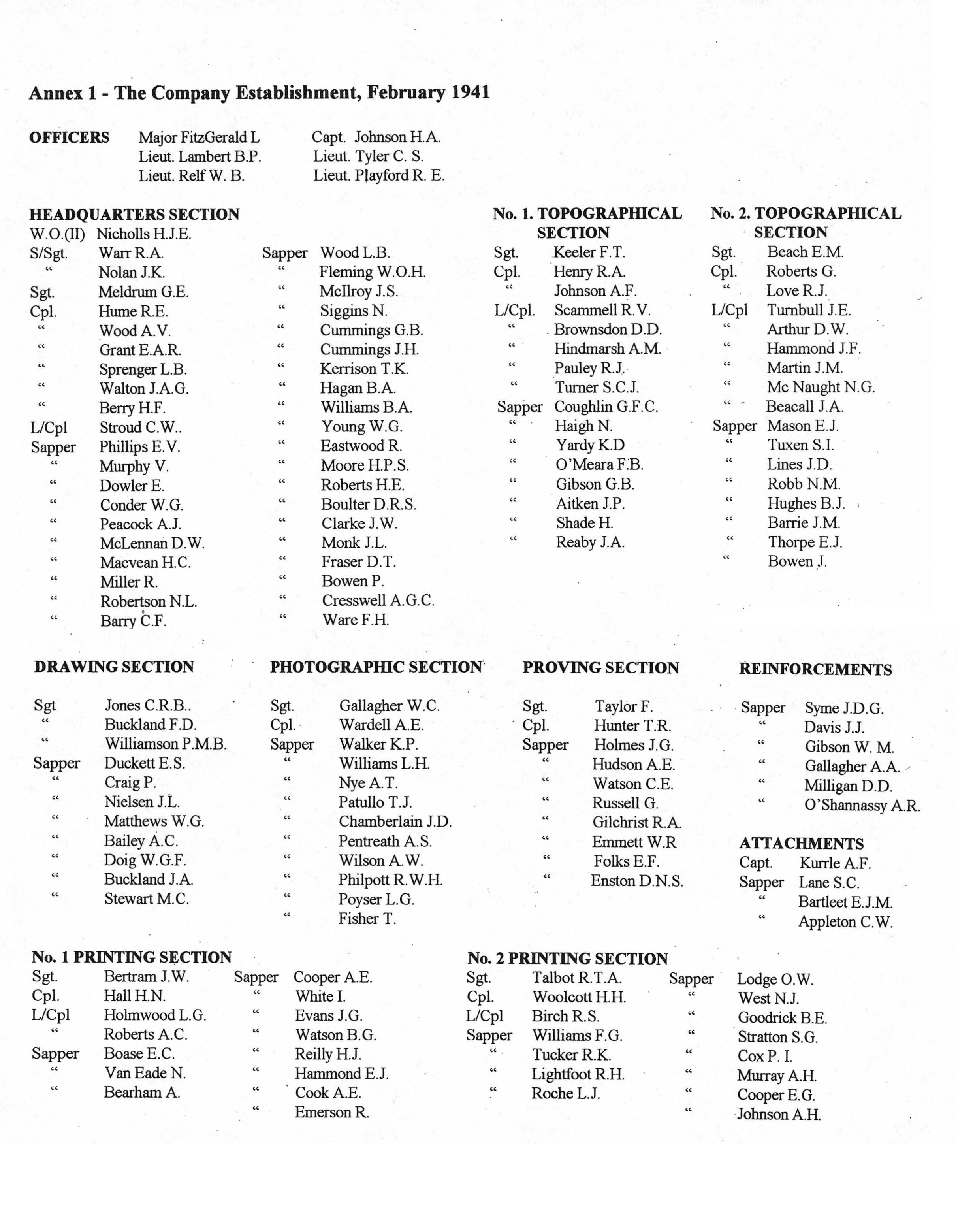
Annex 1 - The Company Establishment, February 1941
Annex 2 - Maps and Miscellaneous Printing, Middle East
Annex 3 - Nominal Roll of Members 1940-1945
Introduction and Acknowledgements
This concise history has been prompted for two reasons, firstly an overall account of the Unit's activities during the period 1940-1945 has never been completed, and secondly, this information was requested in 1997 by the author then commissioned by the Army to prepare an official history of the Royal Australian Survey Corps and its predecessors, the Australian Survey Corps and the Survey Section, Royal Australian Engineers.
A history of the 2/1st Corps Field Survey Coy. RAE, later the 2/1st Aust. Army Topographical Survey Coy, was commenced in the mid-1970s when the Committee of the 2/1 Survey Association established a subcommittee to undertake this task, with the first Officer Commanding the Unit, Brigadier L. FitzGerald, late Army Director of Survey, as Chairman. The intended publication of this work was made feasible by the offer of one of the members of the Association, Jack G. Holmes, to underwrite, print and publish the book, which in due course he did quite handsomely, even though the subject matter was not in accord with the original intention.
With the passage of time, this intended dedicated history veered away from the original intention with the text taking more and more of an expanded form pursued by the Chairman. The sub-committee gradually dissipated, and the history of the 2/1st became submerged in a piecemeal and incomplete fashion in the much wider subject matter which appeared as Lebanon to Labuan, under the pen of Lawrence FitzGerald. This publication dampened the enthusiasm of the members of the Association towards tackling the subject once again, but now over half a century since World War 2, this history for the reason stated earlier, has been related in its continuity, albeit in a somewhat condensed form.
The size and presentation of this book has been governed by production costs and the estimate of the market prospects. The Association now much fewer in numbers, has very limited funds, and a reasonable standard of publication has only become feasible with the assistance of a grant from the "Their Service - Our Heritage" Programme administered by the Department of Veterans Affairs. The interest of the Department in encouraging the recording and publishing of the nation's military heritage is both commended and welcome.
In preparing the text at this time, now far distant from the events related, much of the action is not recalled with exactitude, which is understandable. Fortunately, access to the Unit War Diaries now open for perusal at the Australian War Memorial in Canberra, File references AWM 52-6/1/10 and AWM 52-6/1/21, has been invaluable in clarifying and verifying much of the material except that the War Diary for the Detachment at Hollandia, although undoubtedly completed at the time, is not with the Files.
The Honour Roll has been checked with the War Graves Commission.
Contributions have come from several members of the Association, with in some cases recollections being supplemented by personal diary entries.
Other primary references have been Lebanon to Labuan by Lawrence FitzGerald, 1980, and a substantial edition of the Survey Sentinel, June 1990, published to mark the 50 years since the Unit was formed at Puckapunyal in 1940. Some of the much more modest wartime editions of the Unit's Survey Sentinel have also provided background. As map reproduction techniques have changed remarkably since the 1940s, interested readers can refer to some technical notes about the original equipment appearing as Map Reproduction In The Field 1940-45, Cartography, Vol.22, No.1,. June 1993 published by the Australian Institute of Cartographers.
The maps included have been prepared for this history by a member of the Association, Byrne E. Goodrick, and the publication arranged by the Secretary, John D. Chamberlain.
While much effort has been expended by internal referees to proof read and detect errors, it is still possible that some minor errors exist, but we have done our best within the time constraints and the information available at this distance from the scene of the actions.
2/1st Corps Field Survey Coy. RAE
With the outbreak of World War 2, the operational plans for the raising of the Second AIF were speedily put into place with the raising of the Sixth Division and the subsequent Divisions and Corps troops which together formed the 1st Australian Corps AIF. Among the supporting Corps troops to be raised was a survey company which at that time was without a precedent in Australian military establishments. This was to be raised as the 2/1st Corps Field Survey Coy within the structure of the Royal Australian Engineers. The 2 before the designation of a Unit indicates that it was raised as a Unit of the Second AIF.
It is evident that the model for the raising of a survey company in Australia came from the Corps of Royal Engineers (RE) in the British Army. Survey and mapping support for the British Army had long been provided by RE Survey Companies, which operated on a worldwide basis.
Back in 1930, the need for such a unit in wartime was foreseen by the Chief of the Imperial General Staff, UK, in the CIGS Periodical Letter No.1/1930. An extract reads:
"The function of Army and Corps Field Survey Companies is to produce maps in the field and to supply to the Royal Artillery and others who require it, trigonometrical and other data required for the control of their surveys.
For production of maps the GHQ and Corps Field Survey Companies contain trigonometrical and topographical surveyors and computer personnel. In all cases the trigonometrical surveyor is also a trained topographical surveyor as well as a computer. These men are competent to carry out triangulation, traversing, plane tabling and other survey work on the ground. Where no survey data exists it will be their duty to carry out such triangulation, etc. as may be necessary to provide data for artillery surveys and for the control of any mapping which is undertaken.
The mapping, it is expected, will be done principally with the aid of air photography, and details of the technical methods which it is proposed to employ are still being worked out. The companies contain a proportion of draughtsmen specially trained in these aerial photographic methods.
Lastly, the companies contain litho and photo sections, whose duty is the reproduction and printing of the maps drawn by the drawing sections. For this purpose it is proposed to provide the company with specially designed mobile printing equipment, probably carried in a mechanically propelled vehicle. The design both of this special printing equipment and of the vehicle in which to carry it is still under consideration".
Although this CIGS Letter did not receive active attention in Australia until the outbreak of war in 1939, it then became the blueprint for the 2/1st Coy and on this basis; the framework for the personnel and equipment was designed. The peacetime Survey Section RAE and its successor, the Australian Survey Corps, had survey and drafting capability only, with map reproduction work being performed by Government printing agencies. To translate the map reproduction requirement to a mobile survey company then became a new experience.
The 2/1st Corps Field Survey Coy. RAE came into being on 22 April 1940 when Captain L. FitzGerald was promoted to Major and given command of this Company raised as an engineer unit of the AIF. Recruitment of the many specialist personnel required then proceeded, built around 4 Officers and 5 NCO's from the permanent army Australian Survey Corps who had volunteered for this AIF service. Others came from a small militia survey unit formed earlier in the year which was in training at the Mount Martha camp south of Melbourne under command of Captain B.P. Lambert, a militia artillery survey officer. Lambert came to the 2/1st as a Lieutenant. Others again came by word of mouth, particularly from the ranks of surveying and printing. The majority were from private enterprise with some from Government organizations. A sprinkling had previous military training in the militia forces.
After assembling about 70% of the newly recruited Company at the Recruit Depot at the Caulfield Racecourse on 10 June 1940, these moved by troop train and road trucks to the Puckapunyal Camp near Seymour in central Victoria on 13 June. 10 June is generally regarded as the date the Company was formed. Puckapunyal was a wartime camp set up for training AIF units, which at that time consisted of infantry, pioneer, artillery, engineer and medical units, and some Corps troops, mostly elements of the Seventh Division.
After basic military training to turn civilians into soldiers, the emphasis then moved to acquiring the technical skills deemed necessary to perform the variety of duties foreseen when the Company was ready for active service duty. The acquisition of the equipment necessary to do all these tasks was in itself a large task, as although there was no doubt a War Establishment Table available from the Royal Engineers, Australian Ordnance Depots were not immediately able to supply most of the technical equipment required.
The 2/1st Survey was a field force unit, committed to map preparation and reproduction in a mobile field situation. Although the permanent army Survey Corps personnel in peacetime had expertise in surveying and fair drawing of topographic maps, the Corps had not been directly involved in all the various processes needed to produce the end product, the printed map. Experience in photo-lithography had been confined to doing the work needed on already processed plate glass negatives for the subsequent production of offset printing plates by Government Printing Office resources which undertook all map printing.
The war establishment of the Company when first raised included one photographic section, one proving section and two printing sections, totalling in all 52 personnel and 36% of the Company strength of 145 all ranks.
Lieutenant C.S. (Tim) Tyler, a permanent army Survey Corps draftsman who had been promoted to commissioned rank and had transferred to the AIF as one of the first members of the Unit, was the officer responsible for this large proportion of the Company. His was the herculean task of the identification and acquisition of a very wide range of equipment and material, and also in taking an active part in the recruitment of suitably experienced and committed personnel.
The great majority were new to any life, and to most the prospect of map production was a new experience. Among their ranks they included typesetters, photographers skilled in wet plate/dry plate/film, litho artists and retouchers, dot etchers, plate grainers, plate makers, printing machinists and engineers. Engineering technicians were also needed to provide and maintain the electric power load required by all the acquired equipment. By the time the Unit was ready to go overseas, all of the postings requiring technical knowledge had been filled by those who had been employed in the printing industry, and a smaller number who had served the industry in various ways, or had acquired skills in other occupations which were of value in map production. One of the latter was a qualified industrial chemist. Many of these volunteers were experienced tradesmen, but more than half were from the apprentice or junior ranks.
As there was no equipment on hand to be used for broadening their training, in September the map reproduction personnel undertook a six weeks dedicated training course at the Melbourne Technical College to enlarge their own skills as necessary, and increase flexibility across the boundaries of the trade disciplines. As the Company was expected to operate in a mobile situation, the heaviest equipment being the two Mann single colour double demy (35 x 22½ inches) printing machines each weighing two tons, the proving press and the power generators had to be trailer mounted. The printing machines had to be compulsorily acquired from private industry. Associated equipment was acquired as available, but some, notably the wet plate process camera and a vacuum printing frame had to be designed for mobile operation, manufactured and tested prior to embarkation. As all this equipment came to hand it was packed and stored in Melbourne ready for shipping.
The survey sections had a miscellany of secondhand instruments acquired from many sources for use in adapting their previous surveying experiences to triangulation and plane tabling techniques which were new to many. Plotting from aerial photographs using the Arundel method was also instituted, but the emphasis was on plane tabling, as aerial photography suitable for mapping was not freely available.
All the technical training was interspersed with straightforward military training, route marches, changing of the guard competitions, and the Brigade sports where the Unit did itself proud by finishing second against the much larger battalions and regiments.
By November, and still no word of embarkation, the survey sections moved to the Bendigo Showgrounds which was used as a base for the preparation of a 1: 50,000 map in the Ravenswood area to the south of Bendigo. This involved reconnaissance, beacon building, second order triangulation, computations and plane tabling for detail. This was something of a full dress rehearsal for more serious operations.
During this period, the remainder of the Company, needing a change of diet from straight military training as all the heavy gear was now being-packed for movement, undertook a four day route march in full battle order from Puckapunyal to Bendigo, a distance of some 60 miles (100 km), bivouacking along the way. The musical accompaniment was one side drum and one set of bagpipes provided by two members of the Unit. The marchers are shown rounding the fountain in Pall Mall in Bendigo. By this time, the Company had settled to a fairly well-tuned unit. There had been a few who came and went - one or two compulsorily over the formative period, but the finally assembled members of the Company were enthusiastic, and looking forward to putting their training to good use under active service conditions.
When the warning order for movement was received late in the year, final (pre-embarkation) leave was granted over the Christmas period. After this, the Company joined with other units in a march through the streets of Melbourne on 24 January 1941. The photograph shows the Company passing the saluting base on the steps of the Melbourne Town Hall. The personnel destined for overseas service are shown in Annex 1, and comprised the War Establishment of 145, 6 reinforcements and 4 attached personnel - a total of 155 all ranks.
All the Company equipment had been shipped ahead on a freighter, and personnel only embarked on the RMS Mauretania, then known as BM Transport MX3, on 5 February 1941. South of Tasmania, a convoy consisting of the Mauretania, the Aquitania, the Queen Mary, all with Australians on board, and the Nieuw Amsterdam from New Zealand, was formed, truly a very valuable convoy said to be capable of outrunning enemy submarines, 'given the opportunity. HMAS Hobart was the principal escort vessel.
The Company, after the ships rolling and ensuing seasickness, enjoyed some welcome time ashore at Fremantle where the convoy arrived on 10 February and departed two days later, arriving at Bombay on 22 February. Here the large passenger ships turned back, and their passengers offloaded to smaller ships which were rather a motley collection. The 2/1st was transferred to the Khedive Ismail, a converted British India Company ship previously used for the transport of British Army cavalry horses. Here you ate in the holds and slept in hammocks slung overhead. On 26 February, a newly assembled convoy of about 15 ships departed Bombay for Port Taufiq at the southern head of the Suez Canal, arriving on 15 March, after being anchored in the Red Sea for four days. While anchored, the water consumption by those on board caused the ship to list several degrees. With the makeshift latrines built transversely across the deck and the outlets located against the ship's side, it seemed inevitable that the outlets were on the uphill side of the troughs when the ship began to list.
From here, the Company moved by rail, crossing the Suez Canal at El Qantara and arrived at El Madjal in Palestine on 18 March, then moving to a training Camp in the vicinity known as Hill 69. This camp was about 35 miles (60 km) from Jerusalem, and most had the opportunity of having some day leave in the city over the Easter period. On 28 March the equipment started to arrive, and on 15 April, the personnel by rail, and the stores by road less the two printing machines which had not arrived, left Hill 69 for Egypt and arrived at a camp at Amiriya, not too far from Alexandria, on the western side of the Nile delta, at midnight the next day.
At that time the Company was a component of Lustre Force which was to reinforce the AIF 6th Division in Greece which was in action against the Germans who had invaded that country from the north. Shortly after arrival at Amiriya, orders were given for the Allied troops to evacuate from Greece, so the Company was re-directed back to Palestine, leaving Amiriya on 21 April and arriving at a permanent British Army camp at Sarafand, about 6 miles (10 km) south from Tel Aviv.
Fortune smiled on the 2/1st on this occasion, as it was later learned the British Army 517 Corps Field Survey Coy RE, an equivalent Company already in Greece, lost many men and all their equipment in the evacuation. Survey Directorate, Captain A.F. Kurrle and 4 ORs, as part of 1 Aust. Corps HQ, who had already been operating in Greece, lost Sapper C.W. (Warwick) Appleton, who had trained with the Unit, when his ship was sunk during the evacuation from Greece. He was later presumed dead.
As soon as the stores arrived back from Egypt, the two survey sections and part of the drawing section moved on 30 April to Mafraq a small settlement in Trans Jordan at the intersection of the old pipeline running from Kirkuk, north of Baghdad in Iraq, to Haifa, a port on the northern coast of Palestine, and a railway between Amman in Trans Jordan and Damascus in Syria. To the east was desert.
The field task was to extend the triangulation easterly along the southern side of the Syrian border prior to the invasion of Syria by two Brigades of the 7th Division AIF and other Allied troops, and then follow up with mapping using plane table methods where the map is compiled on a drawing surface attached to a rectangular board mounted on a tripod. No aerial photography was available. The field mapping was done at 1: 50,000 scale. The Vichy French along the border displayed some interest in these activities, so it was good to be under the watchful eye of armed patrols of the Trans Jordan Frontier Force. Further to the east in the desert areas, the Bedouin were friendly observers once they accepted the survey parties were Australians in spite of not having emu feathers in their hats as their fathers did before them in World War 1. As the mapping then existing along the boundary between Palestine and Syria which had been prepared by the Survey of Palestine as far east as Irbid in Trans Jordan had been considered adequate, the task of the 2/1st was to extend this work eastwards from Irbid. As the triangulation data tended to arrive about sundown each day, most of the computations made with the use of logarithmic tables, were made well into the night within very hot blacked out mud huts, aggravated by kerosene pressure lamps. Very dry work !
While the field work was progressing, at HQ, Captain Johnson, the 2IC was undertaking and finally completing a very large geodetic adjustment taking in triangulation data of the Survey of Palestine, some older adjoining Syrian data and the extensions into Trans Jordan to produce a set of sympathetic co-ordinates on the Transverse Mercator Grid adopted for that area.
The weather was very hot, and usually the only shade available to the plane tabler to eat his midday rations was under the plane table. Back at the base camp somebody had discovered that the British Army supply point at Irbid further to the west which supplied the rations, had access to some Fosters beer, the first encountered in the Middle East. This made up for a persistent diet of tinned herrings.
From Mafraq, the work was extended southwards towards Zerka, the HQ of the Trans Jordan Frontier Force where the base camp was set up on 9 July, two days after the invasion of Syria began. Although not passed on to the survey sections at the time, the prompting reason for this extension of the area to the south, apart from the fact that there were no reliable maps, was concern at top Army level that should the Germans, having overrun Greece and established a foothold in the Balkan countries, break through to the south through Syria, this mapping would be required. With the completion of the survey of the Amman sheet, the survey and drafting detachment moved back to Company HQ at Sarafand on 7 July.
After arrival at Sarafand from Egypt, the printing sections were hampered by the still awaited delivery of the two printing machines and the proof press. Consequently, Sergeant R.T.A. Talbot and 8 ORs were posted for duty with 512 Army Survey Coy. RE at Abbysia Barracks in Cairo, and arrived on 8 May. The 512 Company was shorthanded having lost some of their number in Greece. A month later they were joined by another eight, with the detachment returning to the Unit on 24 June. Also in May, the Survey of Palestine in Tel Aviv made available to the Unit a rotary printing machine and a proof press. The Unit's own heavy equipment had come on site on 24 June, after which the Company became self-sufficient, with all reproduction work being done internally.
While here, Sapper J.D. Chamberlain, with the Unit's panoramic camera, was detached to a British Army field survey unit for three weeks to take photographs of the field of fire from the slits of a number of concrete pill boxes along the. Jordan Valley and in Trans Jordan which had been sited for the defence of Palestine. There was no other camera available in the Middle East forces which could do this work.
The time at Sarafand saw the birth of the Unit newspaper, the Survey Sentinel. The original was produced one night as the Survey Scab by Corporal T.R. Hunter and Sapper W.R. Emmett with the aid of the orderly room typewriter and duplicator and distributed at breakfast. Very shortly after, Hunter, expecting a reprimand at least, was called before the OC who expressed approval, and demanded regular publication. The name was changed to the Survey Sentinel, and over the years, more than 50 issues were put together. The contents were confined to Unit news and views, sporting activities, caricatures, satire and concerns of various kinds. The editing and publishing changed hands from time to time, and the presentation improved as opportunity offered. As well as providing some welcome relief from the sometimes tedium of army life, the journal did well in bonding together those performing a wide range of activities. The Unit was fortunate in having some members with a range of artistic talents who contributed to the caricatures.
On 15 July, the survey sections moved to the vicinity of Naqoura, in Lebanon, on the coast about 3 miles (5 km) north of the border with Palestine. Here the task was to relate the Palestine Transverse Mercator Grid to the Levant Lambert Grid in Syria by triangulation observations, and make a start on the mapping of a series of eleven 1: 25 000 sheets required as an extension of the Palestine series. These commenced as plane table work, but later were supplemented by the first aerial photography provided for identification of detail in the field and then to be used by the drafting section for the plotting of the photographs. The photographs were taken from an RAF Glenn Martin bomber with an F8 camera. This work involved subsequent moves of the base camp to the vicinity of Zefta about 10 miles (15 km) south of Sidon, to near Merjayoun, and to Qatana, about 15 miles (25 km) southwest of Damascus in Syria. This task was completed, and on 24 November, the survey sections moved north to pitch camp on the outskirts of two small towns adjacent to the Turkish border, No.2 Section under command Lieutenant Lambert at Akhterin and No.1 Section under command Lieutenant Reif at Aziz, which are to the north of Aleppo.
This area was previously unmapped at large scale, and the task was to produce 1: 50,000 maps along the border area. The border hereabouts was ill-defined on the ground, but sometimes pointed out by rifle shots from the Turkish border guards. After the very warm weather in the Damascus area, the sections experienced snow around Christmas time stacked about 1.5 feet (0.5 m) against the walls of the tents. Surveying on a snow covered landscape was quite a new experience. For this work, a small detachment of survey personnel from the 2/1st Survey Regiment, RAA, AIF, had been attached. An interesting part of the work was the transcription of Arabic names on to the field sheets, particularly when several contributors with proclaimed local knowledge did not always agree. Occasionally, army employed interpreters were available to the field staff, but were not always successful for various reasons. A check list of the Arabic spellings for a variety of geographical features was used to maintain some degree of uniformity in the naming of features.
Meanwhile, the Coy HQ, reproduction and drafting sections had moved from Sarafand to Souq El Gharb, a small town at about 2500 feet (750 m) in the hills about 15 km southeast of Beirut in Lebanon. HQ 1 Aust. Corps was then located in Aley, a nearby town. The premises occupied by the Unit had been a secondary school, which offered shelter for much of the activities, with only the trailer mounted equipment operating in the open. Just after Christmas, heavy snow fell in the area, after which, it was observed that the machines had then printed in temperatures ranging from 25° to 120° F.
In the Middle East, the Company did not have any typesetting equipment, with the result that all linework and lettering for the finished map was done by hand, again in a wide range of temperatures.
A listing of the variety of reproduction tasks undertaken by the Company since arrival in this theatre of operations is shown in Annex 2.
Early in January 1942, Major FitzGerald was attached to Survey Directorate, Eighth Army in the Libyan Desert in North Africa, for the purpose of observing an RE Survey Coy functioning in mobile warfare and battle conditions. Captain Johnson administered command for this period, during which orders were received to pack and leave the Middle East for service in the Far East theatres. FitzGerald rejoined the Company on 22 January and the complete Company moved from Souq El Gharb on 24 January to an assembly camp at Khassa in Palestine. Here all equipment was brought up to strength, and on 29 January all the motor transport left by road for Port Taufiq, including two new trailer mounted 25 KVA generators just delivered. The remainder of the Company departed Khassa and arrived 24 hours later on 6 February at the Suez transit camp.
On leaving the Middle East theatre, the OC received the following message from Colonel A. Prain, the Deputy Director of Survey at HQ Ninth Army :
"On the occasion of your leaving Ninth Army I wish to put on record my appreciation of the excellent work your unit has done while it has been in Palestine and Syria.
The technical standard of each man is high and the spirit of willing and cheerful teamwork has, on all occasions, enabled the best use to be made of this talent.
Your record is a fine one. It has certainly contributed to the War Effort and is appreciated by all for whom you have worked.
I am proud to have been associated with you and your Company and I wish you equal success in any other war sphere you may find yourselves in."
On 8 February, 3 ORs and the three heavy trailers with their 3-ton tractors left Port Taufiq aboard the SS Somerville. The next day, Lieutenant Lambert and 18 ORs left aboard the SS Maple Leaf with all the remaining transport loaded with stores, and on the 18th, 5 Officers and 115 ORs embarked on the RMS Andes, and left port the same day, and arrived at Colombo on 27 February. In the harbour there was a large number of ships laden with troops such as the RMSs Strathallan and Orcades. Shore leave was forbidden, and the Andes and some other ships left Colombo with a cruiser escort on 2 March. There was naturally some speculation as to the destination as all the winter uniforms had been put into store on the passage between Aden and Colombo. The first notification of the destination came with a ship's broadcast from Major-General Herring that it would be Australia. It was much later learned that Australian troops in ships not far ahead had been landed on Java, some without their weapons which were coming forward on slower freighters, and had been captured by the Japanese.
In July 1941, 15 reinforcements arrived in Palestine and were allocated for duty with the Unit. Some had previously had some training with the unit at Puckapunyal. When the Unit packed for movement, two could be absorbed into the Company and as the remainder were "over establishment", they were returned to the reinforcement depot. Here some were posted to other engineer companies, and the others eventually returned to Australia along with many other reinforcements on board a French ship Felix Roussel. Many of the ship's complement were from hospitals, convalescent depots, military prison inmates and police, and others whose services were no longer required. From all accounts this was a very uncomfortable journey made worse on occasions by troublesome prisoners whom the reinforcements were often obliged to control. Eventually all the survey reinforcements made their way back to the Unit in Australia.
The Andes arrived at Fremantle on 10 March, with a brief shore leave given to Western Australian personnel only. Free semi-official telegrams provided to all ranks who wished, were despatched to Next of Kin, stating arrival in Australia. Large quantities of recent mail were taken on board. The ship departed Fremantle on 11 March and arrived at Outer Harbour, Adelaide on the 15th. The SS Somerville with the 6 ORs and the three heavy trailers and tractors docked at Port Adelaide the same day, and when unloaded, moved to a pool at Camden Park near Glenelg. The following day, all personnel on the Andes disembarked and proceeded by tram to Payneham, an eastern suburb of Adelaide, where they were billeted in private homes, mostly in Avenue Road. The residents made their new found visitors very welcome, with the troops being allocated four, six or even eight to a household.
By the 21st, the SS Maple Leaf with the remaining troops, transport and stores had berthed at Port Adelaide, been unloaded and moved to Camden Park. By the 26th, the whole Company was in billets in Payneham and repacking prior to movement to Melbourne, where Major FitzGerald had already reported to Army HQ. Captain Johnson was the acting Officer Commanding from this date, and shortly after FitzGerald was promoted to Lieutenant-Colonel and appointed Deputy Director of Survey, HQ First Australian Army, which was then responsible for the country's defence from Thursday Island to Brisbane. Apart from a few maps around the Brisbane area, there was then no topographic mapping available along this 1000 mile long strip of Australia.
The Company and all vehicles except the three heavy trailers, which were too high on the railway trucks to negotiate the tunnels, left Adelaide for Melbourne on 4 April, arriving at 2230 hrs on 5 April when all with homes in Victoria were given seven days disembarkation leave. Temporary HQ was established at Allardyce's garage at St. Kilda Junction on the 6th with some HQ staff and guard personnel being retained for duty.
By 21 April, the Unit was again on the move with the first convoy of 1 Officer and 40 ORs with 18 vehicles leaving for the Toowoomba area, travelling along what is now the Newell Highway in New South Wales. This convoy was largely composed of the field survey sections. A second convoy of 1 Officer and 19 ORs with 7 vehicles followed on the 23rd, with the remainder of the Company leaving Melbourne on the 25th by train for Toowoomba. By the 27th, the train travellers and the first convoy had arrived in Toowoomba with the convoy going on to a property named Gowrie at Kingsthorpe about 10 miles to the northwest with a view to setting up Coy HQ. The old homestead was not considered suitable for the various reproduction activities, and after further search, on 30 April, another property named Gabbinbar about 4 miles (7 km) to the south of Toowoomba was selected and occupied on 2 May. This was to be Coy HQ with drafting and reproduction facilities for the next 10 months.
On 7 May, the two survey sections under command of Lieutenant Relf moved to Brisbane by road, then on to Townsville by rail. The base camp was set up alongside Alligator Creek about 10 miles to the south-east. The task here was to prepare maps at 1: 63,360 (one inch to one mile) around Townsville, where no topographic maps of any kind existed.
In summary, the object was to produce a map in its correct position on the face of the earth, oriented to north, uniform in scale, and within small limits, complete for position, height and shape of the topography.
Captain Johnson had now joined the survey parties, with Lieutenant Relf returning to Toowoomba. Firstly, a suitably level site was located for a second order baseline which was then laid out and measured, and its astronomical azimuth determined. From the terminals, the baseline was extended by triangulation to cover the area to be mapped. Positional and height data was determined by connecting to a Lands Department pre-war astronomical fix located in the city area. The clearing of hill tops necessary for the building and all round visibility of survey beacons was quite a task, as the timber cover was usually iron bark eucalypts which required the axes to be kept very sharp. Care and attention in clearing operations was emphasized when Sergeant Frederick T. Keeler was crushed and killed on a hill top on 24 June, when a half dead tree unexpectedly swung when being felled.
As co-ordinated trig stations with their heights above sea level became available, the area was parcelled out to the plane tablers, who by this time were quite experienced. Aerial photography was not available.
The field group was later to have the 5 Field Survey Coy., a militia unit raised in Brisbane as the Northern Command Field Survey Coy., camped nearby, the object being to provide on-the-job training to the 5 Coy personnel in the triangulation and plane table techniques practised by the 2/1st Coy. This would have been quite a happy arrangement but for the gross discrepancies in the NCO ranking structure between the two Companies. The Command Companies provided for 3 warrant officers, 4 sergeants and 6 corporals to an individual survey section, as opposed to 1 sergeant and 2 corporals for each of the two survey sections of the 2/1st. With the combination of those told off to provide training to quite senior NCOs, and the often reluctance amongst the newcomers to accept the "one in, all in" approach of the 2/1st, the training was not as effective as had been hoped, and after the Townsville work the two companies were separated. It took some months before this structural imbalance was largely corrected, but in the meantime some members who were qualified to do so, in response to advertisements, submitted applications for transfer to the RAAF to train as aircrew. It seems these never got any further than Coy HQ.
In all, five "Inch to the Mile" sheets were completed around Townsville, and despatched to Coy HQ at Toowoomba for drawing and reproduction.
In the first days of this work, the ground troops witnessed the many American and RAAF aeroplanes from a string of aerodromes in the area, crossing the coastline to and from bombing missions against the Japanese navy - the momentous Battle of the Coral Sea.
On 29 May Captain Johnson was promoted to Major, and appointed Officer Commanding. Shortly after, Lieutenant Lambert was promoted to Captain, whereas 2 IC he was responsible for the HQ and reproduction activities at Toowoomba. The OC returned to HQ at the conclusion of the Townsville work, and Captain Lambert took command of the field activities on the move to Cairns. The work at Townsville was necessarily a seven day a week operation.
In June, Sergeant Beach was temporarily detached to observe some astronomical fixes in the country to the south of the Gulf of Carpentaria to provide some base information for a company of the 2/1st North Australia Observer Unit which was operating in this area. Part of their duties was to gather topographical intelligence as the existing maps of the area were small scale and skeletal at best.
After arrival at Gabbinbar, the drawing and reproduction sections were quickly in action, with work coming forward froth a variety of sources. These included a number of 1: 63,360 maps along the coastal areas of Queensland compiled from cadastral maps as emergency editions by 1 (later 5) Aust. Field Survey, Coy, road maps, small scale maps, propaganda posters, and by September, some early provisional sketch maps of New Guinea. In the latter part of the year, both of the printing machines were working on a 3 shifts per day basis.
With the Townsville work completed, the survey sections moved by rail to Cairns on 3 July, and occupied a vacant house in Lake Street. At this time many of the inhabitants had left the town for the more secure areas closer to Brisbane, with those remaining mostly being involved in business activities. Here the survey sections were joined by the drafting section located also in vacant premises in Lake Street. The 2/1st was the first AIF unit to be posted to this area.
The priority task was to map the Cairns, Gordonvale and Macalister Range sheets at 1: 63,360 scale. The field operations were to be essentially the same as at Townsville with the same sequence of operations except for one important difference in that aerial photography of these three "One Mile" areas carried out by Flying Fortress aeroplanes of the US Army Air Corps at that time based in the Townsville area, became available through the representations of Captain Johnson, and plane tabling for planimetry was no longer necessary. After work along the coastal area which was related to a base line measured near Gordonvale, the survey sections then moved to Tolga on the Atherton Tablelands where a further base line was measured near at Kairi near Atherton. The mapping ranged over an area including Biboohra, Dimbulah and Herberton.
Much of this work was to be later used during the assembly and training of the 7th and 9th Divisions and supporting troops on the Tablelands, prior to their operations in the Borneo area.
2/1st Aust Army Topographical Survey Coy.
On 8 July 1942, the 2/1st Corps Field Survey Coy RAE was disbanded, and a new establishment with the same personnel came into being as the 2/1st Australian Army Topographical Survey Coy. This was to be a much enlarged Company consisting of 10 Officers and 242 ORs, and was intended to serve the 1st Aust Army rather than just the 1st Aust Corps. In this new establishment, the NCO ranking structure was much improved, though still inferior to the Command Survey Companies.
Towards the end of August, promotions began to take effect, and the enlargement of the Company began with absorption of some members from the 2/1st Survey Regiment RAA, now disbanded, and the swearing in of new AIF personnel, with some coming from the Survey Training Depot which had been established at East Burwood, a Melbourne suburb. A number of personnel from the then disbanded 7 Aust Field Survey Section which had been operating in the Northern Territory, were also taken on strength.
On 20 August Captain Lambert left the Unit to take command of and form the new 2 Army Topographical Survey Coy at Colac to the west of Melbourne. This Unit was later renamed the 6 Coy to avoid confusion with the 2/1st.
Lieutenant Reif was promoted to Captain on 1 September and with some of the additional personnel now available, took a survey party to extend the existing triangulation north from Maryborough to Rockhampton and with this completed, some work along the McPherson Ranges in the border area between Queensland and New South Wales was then put in hand. The party was based on Gin Gin, returning to HQ on 18 October.
On 20 October, as news came that a detachment was to go to New Guinea, the survey Sections were withdrawn from the Tablelands and with the drawing section from Cairns, returned by rail to Brisbane and road to Toowoomba arriving there on 15 November. After regrouping and some additions to the survey sections and without motor transport, Captain Playford with necessary stores and the two survey sections now under command of Lieutenants E.M. Beach and G. Roberts, and the drawing section under command of Lieutenant F.D. Buckland together with 68 ORs, left Toowoomba on 24 November and arrived at Oonoonba staging camp outside Townsville by rail on 30 November for onward movement by ship. This was the first encounter with hordes of mosquitoes after sundown, and with no mosquito nets, most slept downwind of cow dung fires. This staging camp at that time was a very primitive establishment.
The detachment sailed from Townsville on the TS Taroona on 8 December and arrived at Port Moresby on 12 December, where HQ and the drafting section were established in an abandoned house in Simpson's Gap in the town area. It was not long before the detachment received its first experience of Japanese bombing, no doubt attracted to some extent by the heavy anti-aircraft battery nearby.
On 20 December, No.1 Section under command Lieutenant Beach with 18 OR's was air-lifted north over the Owen Stanley Ranges to Dobodura to provide survey and associated mapping support for the final actions by the predominantly Australian forces to clean out the Japanese in the Buna/Gona area. They were camped with Advanced HQ New Guinea Force, but were divided into three parties operating in the Oro Bay, Cape Sudest and Soputa areas. Apart from astro-fix and associated survey work to improve positional data, much of the work related to marking up badly clouded aerial photographs, and gathering and compiling situation reports for transmission to Port Moresby for progressive updating of the initial maps provided, which were based on skeletal data of pre-war vintage. Much better detail was to be added from interpretation of some contemporary aerial photography where the detail was not obscured by cloud or hidden by the rain forest and swamp growth. On Christmas Eve, Sergeant N.M. Robb and Cpl N.G. McNaught survived a strafing attack by a Japanese Zero aeroplane while doing a midday latitude observation on the sun alongside the No.1 airstrip at Dobodura.
Lieutenant Beach returned to HQ on 1 January with marked up photos and the survey results. These showed the grid on the old Buna Sheet to be 22 degrees out of orientation. The new grid was not acceptable to the artillery as it would necessitate changing their already co-ordinated reference points which had been put together under very adverse conditions. By the end of January, the section had become ineffective as some had been recalled for other tasks, and of the others, most had been evacuated for medical reasons. When Beach returned after a few days, camp was moved to Popondetta to complete the immediate survey task, with the remaining members of the party returning to HQ in Moresby in mid-February.
Meanwhile, on 28 December, 1 x 3-ton and 5 x 15cwt FWD vehicles had arrived for the detachment, having left Brisbane on 12 December.
No.2 Section under command Lieutenant Roberts with 20 ORs and one 15cwt FWD vehicle was moved by a very ancient small coastal freighter, the SS Royal Endeavour, to Redscar Bay in the Galley Reach area about 30 miles to the west of Port Moresby on 30 November. There were no maps of this isolated area, and this survey was a precautionary measure in case the Japanese came down from the highlands to the north or northwest. The country was mostly flat and swampy, interspersed with coconut plantations, so most of the work was done by plane table and theodolite traversing to position significant map detail, as aerial photography was not available at the time. Astro-fixes were observed alongside the Rorona airstrip at Galley Reach, and at Magabura on Redscar Bay. This job was short lived and unremarkable except for the hordes of mosquitoes which attacked at all times. Without help from another to ward off the mosquitoes, observing with instruments was just about impossible. The Section was recalled to Port Moresby by ship on 19 January.
At this time, the only medication available to help ward off malaria was quinine in tablet form - atebrin came later - and these tablets were not always available. Virtually every member of the field survey sections went down with malaria at various times over the ensuing months.
The drafting section in their deserted house in Port Moresby, had to exercise considerable enterprise in making use of a lot of mapping material under the headings of good (very little), indifferent, and "rough as bags". An occasional captured Japanese map was sometimes useful. As an illustration of available topographic information, the 2/1st at Toowoomba reproduced the 2nd Edition of the Buna 1: 253,440 map in November 1942. This shows only skeletal detail in black and white, being made without recourse to aerial photography. This particular map drew a complimentary letter from the GOC New Guinea Force which read :
HQ NG Force
13 Nov 42
G02169
Director
of Survey
ADV
1. On 5 Nov a copy of BUNA 1/4 inch revised map was forwarded to you for reproduction, and, it is presumed, was received by you on 6 Nov.
2. 50 copies of this map reached HQ NEW GUINEA FORCE by safe hand on the evening of 8 Nov, and a further 1000 copies arrived on 9 Nov, reaching formations on 10 Nov.
3. This is a further example of the noteworthy efficiency and splendid cooperation we are receiving from Survey Directorate, and I would be glad it all ranks of your Reproduction Section be informed of our appreciation of the splendid service they are giving us here.
(sgd) E.F. Herring Lt.Gen.
GOC New Guinea Force"
One of the first efforts of the New Guinea detachment was a map known as "GONA No.1 Red", printed early January 1943, and published at 4 Inches to 1 Mile, (1:15,840). This was published in 5 colours through the co-operation of a detachment of the US Army 69th Engineer Coy (Top) set up in Port Moresby. Apart from the topography shown in black, the other colours represented information from tactical reconnaissance in brown, native sources in purple, patrol reports in red and aerial photograph interpretation in green. A general note states that "Majority of terrain waterlogged after rains". This map was used in the final operations resulting in the defeat of the Japanese in the Sanananda Point area, which occurred towards the end of January, and with this, following their other defeats in the Buna area, Papua was then virtually free of the invaders, except for odd pockets to be accounted for.
The 69th Coy printed the first more or less standard format 1: 63,360 sheet, Buna East Special, which was based on astronomical control and prepared by the 2/1st. It was dated 24 January 1943. This was printed in 5 colours and was confined to 15 min. of latitude x 15 min. of longitude, as this was about the maximum paper size the 69th equipment could accommodate. For the larger printed sheets, work was sent back to HQ at Toowoomba by the air courier service.
On 28 December, a survey party was detached for duty with the RAN ships undertaking hydrographic surveys to substantially upgrade the quality of the existing navigation charts. These were pre-war productions, lacking in detail and of similar calibre to the pre-war land mapping in the area. Sergeant R.V. Scammell, Corporal J.E. Turnbull and Sapper D.A.Yardy travelled by small ship to Milne Bay and on 6 January joined HMAS Whyalla, an RAN survey ship which was accompanied by two other smaller survey vessels, HMAS Stella and HMAS Polaris. They had the immediate objective to rechart the passage from Milne Bay to Oro Bay and Buna, which was then still based on very limited pre-war surveys which left many reefs uncharted. These personnel were put ashore by a ship's boat, as required, to observe astro fixes to be used to control the charting surveys. The fixes were mostly used in conjunction with taut wire surveys where very long lengths of wire, over 100 miles on the ship's reel, with one end attached to an improvised anchor, can be paid out from the ship while sailing on a constant bearing. At recorded intervals, soundings and sextant angles are taken to fix the features required for inclusion on the chart. The taut wire equipment was the seaborne equivalent of the measured baseline used by surveyors on land.
The first fix was observed at Tufi, followed by another at Kibirisi Point on Cape Vogel, where they were put ashore from HMAS Stella, then to Porlock Harbour and Mei-Mei-Ara Island just off East Cape at the south tip of mainland New Guinea where some minor triangulation work was also done. Here Corporal Turnbull and Sapper Yardy, both with malaria, were replaced by Sappers K.M. Llewellyn, and B.P. Behan and later Lance Corporal E.J. Thorpe. Further astro-fixes were observed at Cape Mourilyan on Fergusson Island, and the Beli Beli anchorage on Goodenough Island. The party returned to the Unit in Port Moresby on 20 March after being landed at Cairns by HMAS Whyalla on 9 March. Two of their fixes at Tufi and Porlock Harbour were later to be used by the Unit for the land mapping. While working off Maclaren Harbour (Tufi) on 2 January, the ships were bombed by 20 Japanese aeroplanes, with two casualties and some minor damage to Whyalla.
On 13 January 1943, Sergeant N.M. Robb accompanied by Lance Corporal L.A. Anderson and Sapper D.H. Price were flown to Wau with Major Duchatel, an Intelligence Officer with HQ New Guinea Force, who knew the country from pre-war days as a mining engineer and explorer. He was also able to arrange for native carrier assistance to assist the survey party as there was no vehicular transport available. The survey task was to first of all attempt to recover any survey information still available in the now abandoned offices in Wau and to obtain astro-fixes, establish a base line, and from these extend survey control by minor triangulation. Duchatels's task was to scout the area for airstrip sites. The search for local survey information was fruitless as an Independent Coy operating in the area had already been active with a form of a "scorched earth" policy. The party observed an astro-fix, laid out a base line along the aerodrome, and from this extended a triangulation net within the limits of the topography.
This work was prompted by precautions being taken against a probable drive by the Japanese towards the Wau area advancing from their foothold in the Lae/Salamaua area. The survey party worked under the umbrella of the Australian 17th Brigade, which was being positioned against this threat.
The Japanese came up from the Markham Valley and attacked as predicted, reaching Wau with the action culminating on 29 January right on the outskirts of Wau, where after intense fighting they were repelled by the 17th Brigade, and forced to retreat back to the coastal areas over a period. This defeat blunted Japanese aggression in this area, because heavy reinforcements they were expecting from New Britain did not eventuate, as they suffered heavy losses of warships and troop transports during the Battle of the Bismarck Sea in early March.
The mountainous terrain and the tropical vegetation restricted the triangulation extension from Wau to Bulolo, about 25 miles. Beyond Bulolo, going towards the Markham Valley, the nature of the terrain caused a rather different technique to be adopted, referred to as "latitude and azimuth traverse" combined with a narrow triangulation chain. This was not text book triangulation, but very useful when put against the void it replaced. This survey had then been extended on from Bulolo to Mumeng at an altitude of about 5000 feet, which was about another 40 miles, when the Japanese attacked Wau and Duchatel then decided they should rejoin forces. Shortly after, Wau had been cleared of Japanese, so the survey was extended to intersect a sharp peak overlooking the Markham Valley and the town of Lae. At this point, on 7 February, the party had returned to Wau, and flew to Port Moresby, being hastened on the day by an enemy airstrike on the Wau aerodrome. Major Duchatel remained to search out airfield sites in the Ramu Valley. He was to succumb to scrub typhus before the year was out.
With Wau secured, this survey was not to be resumed until 19 March, when a detachment of 8 Field Survey Section from Port Moresby moved to the area to extend the work northerly in the general direction of the Markham Valley and the Nadzab area.
On 29 January, Lieutenant Roberts and 17 ORs departed Port Moresby on a small coastal trader via Milne Bay for Oro Bay on the north coast of Papua about 15 miles to the southeast of Buna. This port had been developed after the previous Japanese occupation, and was used as a supply base for the Australian/American troops in the actions to clear the Japanese from the Buna/Sanananda Point areas. The task was to relieve the Section earlier brought by air to Dobodura, and to survey and map the general base area in the vicinity of Oro Bay at a scale of 1: 15,840 to assist with the development of roads and the general infrastructure of an expanding base facility. After this, the task was to work to the southeast towards Cape Nelson and inland from the western coast of Collingwood Bay. By this time, the Japanese had been successfully cleared from the area, although their bombers were active, particularly against Allied shipping, and the vicinity of the port at Oro Bay. Fairly heavy and frequent enemy bombings occurred during the latter part of the detachment's stay at Oro Bay.
On arrival, the relieving section was met by Sergeant D.D. Brownsdon, the only member of the previous Section still standing, all the others having been medically evacuated to Port Moresby and beyond. The casualties were mostly due to malaria, but also to dysentery, dermatitis and tropical ulcers.
From Oro Bay, the Section moved southerly to Pongani, a coastal village, some taking the inland walking track to mark up aerial photographs and take heights, and others travelled by small boat. Here, an astro-fix was observed, which became the origin for some triangulation extended from a theodolite traverse. These limited surveys were possible as the lower coastal country was more open and offered potential line-of-sight conditions. From around Pongani and previously from Oro Bay, some points along the Hydrographers Range were intersected, along with distant peaks such as Mt. Trafalgar, Mt. Victory, Goodenough Island and Mt. Suckling. This practice was followed at all astro stations visited by the detachment. This proved extremely useful later, when in a few cases, control points for photos were obtained by resection from these points, no other means being practicable. Not very accurate fixes, but much better than nothing in this unsurveyed stretch of Papua!
The Section then moved on by sea from Pongani to Tufi, situated on Maclaren Harbour on the east side of Cape Nelson in fiord type country, where a base was established in a deserted house. Tufi was home to the pre-war District Office of the Government administration service, which in wartime became the Australian New Guinea Administrative Unit, (ANGAU), and an American torpedo boat squadron, and the only place within at least 100 miles each way which afforded any communication or supply facilities at all. The section was fortunate in receiving assistance from both ANGAU and the Americans when the occasion really demanded it, particularly in medical matters. When evacuation for medical reasons became necessary, the Americans transported the patients to a hospital at Milne Bay. These helping hands were also very welcome when at one stage, with the rations exhausted because of delayed shipments from Milne Bay, some assistance was provided with the Section making up the shortfall by bartering for native food.
The type of work done at Pongani was repeated with some variations around Poriock Harbour on the north coast, around Tufi and to the south, around Wanigela in the southwest corner of Collingwood Bay. In addition, a base plot of several strips of photographs was made at Tufi. These photographs were at a variety of scales and compass directions, and the strip plots were manipulated to avoid cloud cover and obtain the best degree of continuity between the available astro fixes at Porlock Harbour, Tufi and Wanigela. This plot was gridded and then had the intersected features and the traversed tracks added to serve as a base for long distance plane tabling. With the limited height information available from field barometers and some vertical angles, the contouring could only be classed as form lines.
Track mapping was an important aspect of the work in these areas. The only means of communication between villages was by foot tracks, and these were virtually impossible to identify on the aerial photography as they were narrow and mostly shielded by the overhead canopy of the jungle. In peacetime the main tracks were kept cleared by adjoining villages being obliged to do so as part of their responsibilities to the Government. In wartime the tracks had been let go to a large extent, so machetes were an essential part of a traveller's equipment.
The technique used to map these tracks was a variation of a method used in parts of Africa in the pre-war times, which was related to and recalled by some members of the Section when yarning with Major L. W. Nesham in the Middle East during his visit to the detachment. Nesham was an English survey officer and at that time, the DAD Survey, Palestine. He mentioned that in heavily timbered country, a traverse technique was used known as "rope and whistle". This involved reading a compass bearing to a whistle sound given by the lead chainman who drew a piece of rope of a known length until he was brought to a halt. At this point he was often out of sight. The straight line distance between the observer and the lead chainman was arrived at by deducting the loss of distance estimated to be due to bends in the track which most often was "all the same snake", after the observer had walked along the section in question.
This technique was modified by the Section using 100 yard lengths of signal wire with the native lead chainman, accompanied by an armed Section member and an armed native policeman, making bird calls. These precautions were necessary in areas where some Japanese, cut off from their own forces, may still have been free. This work involved hundreds of miles of traversing. Remarkably so, these traverses when plotted, generally gave closures at intersections to the order of 5-10%, which again was considered satisfactory when put against the nature of the terrain which ranged from extensive swamps to saddles above 2000 feet in altitude. Leech bites were a constant problem in the higher country, and to counter these, a touch with a lighted cigarette or a slow burning fire stick carried by a native was fairly effective. Nevertheless, many a tropical ulcer developed from the leech bites.
This work could not have been sustained without native carriers to not only identify the main path where it was not immediately obvious to the traverse party, but to carry the rations to feed all hands. The carriers were selected, paid in kind and rationed by ANGAU. Their rations included bags of rice, tinned food and trade tobacco. The Section members were provided with American army "K" rations, packed in light wooden boxes, containing several packs of food each designed to support one man for one day. These were supplemented by an issue of trade tobacco to be used for barter along the way for sweet potatoes, taro and bananas. The load for each carrier was limited to the extent that 15 or so carriers could only manage rations for 12-13 days as beyond this period, each man would eat more than could be carried.
Most of the carriers used for the traverses throughout this area came from the Wonari village, a few miles south of Tufi. Some could speak and understand some English learned in a missionary school, which was very helpful as the Section members at that time were only beginning to pick up a smattering of Pidgin English. These men were mostly cheerful and willing, so much so that often the same ones came along on successive traverses. In Pidgin, a land surveyor was known as "master mark" and had some respect due to the nature of his work often done in bush locations. Some of this respect was seemingly transferred to the Section, and this respect was returned to the carriers for the hard and loyal work they did so well.
The longest traverse of this type was made by Sergeant J.D. Lines, Corporal G.B. Gibson and an ANGAU officer (the Assistant District Officer at Tufi), Warrant Officer W. Moses. The party covered some 110 miles, of which about 70 miles were compass traversed.
Very little of the aerial photography was cloud free, with the result that the coastline had to be followed to record all the habitation. This could not be done on foot, so long sections of the coast, up to 50 miles, were observed from small outrigger canoes paddled by natives. These canoes, called a lakatoi, had only a few inches of freeboard. Eventually, a small motor launch was provided by New Guinea Force, and this was used during its rather short period of serviceability, to obtain astro-fixes as far away as Baiaua on Moi Biri Bay. Astro-fixes were often delayed due to overcast clouds, heavy rain, temperamental radio receiver equipment and battery chargers, and weak time signals.
On 6 June, a 48 feet long vessel, the AS24, capable of carrying 25 personnel and 8 tons of cargo became available to the Section, but too late to be of much assistance.
The work in the Cape Nelson area was terminated on 22 June, when the Section's programme was amended. By this time the field work had been completed for four "one inch" sheets. The mapping of this isolated area, well away from the usual army lines of communication was a new and testing experience in many ways - the background staff work left a lot to be desired. Nevertheless, this work was to be a valuable introduction to surveying, photo interpretation and mapping in the tropics.
While this work was proceeding, 11 February saw Major Johnson leave the Company to become the OC 6 Army Topographical Survey Coy, and Captain Lambert, now promoted to Major, became the OC 2/1st Army Topographical Survey Coy. Major Lambert, with 1 Officer and 21 ORs, shortly after moved from Toowoomba with the Coy HQ to New Guinea. By this time, the reproduction capability of the Unit had doubled in size following the increase in the Unit establishment, and now with four printing machines, two reproduction Sections each built around two printing machines were arranged. One of these Sections was destined for New Guinea, while the other remained at Toowoomba with what was then a detachment of the Company, under command of Captain Relf
During the period 12-22 February, an astro-fix party was flown to Bena Bena to obtain a fix on the aerodrome.
On arrival of the Coy HQ at Port Moresby on 11 March, the Company was allotted a camp site on the south side of the road to Koitaki some 17 miles out from the town area and close to the Laloki River below Hombrom Bluff This road went on to the start of the Kokoda Trail. This campsite, in its natural state, known as the "17 Mile", provided the proximity to water required by the reproduction section. There was much work to be done to form roads, construct essential facilities, build platforms for trailers and so on. By 21 March, Lieutenant H.N. Hall and Warrant Officer II J.A.G. Walton with small detachments had arrived in Port Moresby ex-SS Montoro with the vehicles, heavy trailers and all the equipment necessary for the reproduction and printing of maps. They were all installed at the 17 Mile by 1 April, where the site had been prepared to enable operations to commence as quickly as possible, as maps were in keen demand by New Guinea Force. The printing machines shipped from Sydney had automatic feeders and were much faster than the hand-fed machines used in the Middle East – these remained with the detachment at Toowoomba.
In the period 7 -16 March, Sergeant Robb and Corporal Price had been flown to Garaina in the vicinity of the angle in the International Boundary between the Trust Territory of New Guinea and the Territory of Papua at 8° South and 147° East. Here the task was to obtain an astro-fix, obtain photo scale checks, and report on the accuracy of a map of the area produced in 1935.
In March, a detachment of 3 Aust Field Survey Coy newly arrived from Queensland established a campsite with Coy HQ and a drawing office facility alongside the area occupied by the 2/1st, who printed the maps produced by their neighbouring Company as they came to hand. Adjacent to 3 Coy at the time, was the HQ, drawing office and base camp of 8 Field Survey Section which had been operating in New Guinea since the middle of 1942. Originally, this Section was designated the New Guinea Survey Section, and before the arrival of the 2/1st Coy HQ with its reproduction capability at the 17 Mile, all their printing apart from sun prints, was sent by courier to the 2/1st at Toowoomba.
In New Guinea, map printing in the tropical heat and high humidity brought quite a few problems to be solved. In the Middle East, all the negatives were made on ¼ inch plate glass sheets carried by the Unit and coated as required. This technique, known as "wet plate" photography, was used in preference to pre-sensitised sheet film, which at that time had not been used in Australia in the larger sizes required for maps. When the Company later moved to Toowoomba, the decision was taken to use film exclusively, and inter alia, avoid the logistic problems associated with sheet glass. This was satisfactory in the more temperate climates, but in tropical conditions, the maintenance of the size required on the successive film negatives to be used to obtain exact register for each colour when finally printed, was quite a problem. The alternative to sitting around half the night monitoring a film for when it moved to the size required, and then immediately exposing it on to the printing plate was overcome by an improvised version of the Australian "Coolgardie Safe", the forerunner of the ice chest and the refrigerator. With this, a reasonably constant internal humidity can be obtained by the evaporation from flannel strips with one end in an overhead water tray, hanging down the sides of some sort of mesh material container, hung in a breezeway. This speeded plate making considerably. Fortunately, the Unit had the experienced tradesmen who could adapt to the various problems which arose from working in a primitive environment.
Other problems quickly became evident with the paper size changes after the first run through the printing machine. This had been a problem in southern Queensland, but it was much worse in the high humidity in Port Moresby. It had been discerned after a number of controlled tests that the movement was substantially in the direction of the grain of the paper. After consultation with the paper manufacturers and some trials, it was decided to "size" the cut paper sheets with a methylated spirits based varnish, but this unfortunately gave the paper a yellowish look, which at the time could not be avoided. This treatment considerably improved map register from one colour to another, and became standard in the Company and then with other Survey Corps printing facilities. The sizing was also held to make the paper more durable for use in the tropics, as it inhibited the absorption of moisture to some extent. While it was very useful in map printing, it is doubtful whether it did much for map durability overall.
On 1 April, a re-assembled survey party under command Lieutenant Beach were flown to Kokoda to obtain astro-fixes, heights, feature names and mark photos to enable much better maps of the area to be produced, and to train some newcomers to the Company. By 3 June, all members of the party had returned to Port Moresby.
Lieutenant Beach, newly promoted to Captain, was posted to 8 Field Survey Section as OC, and took command on 19 April. Two weeks later he was joined by Warrant Officer II R.J. Pauley from the 2/1st, to provide the Section with his expertise in astronomical and geodetic computations.
1 May 1943 saw another survey party despatched by air to the Bena Bena and Mt. Hagen areas in the Central Highlands, generally to the south and southwest of Madang respectively. The party comprised Captain R.E. Playford, Sergeant G.F.C. Coughlin, Sergeant W.G. Young and Corporal D.W. Arthur. This area was unsurveyed, unmapped and even not very well known to experienced ANGAU officers from the pre-war civil administration. Army operational plans contemplated the development of the airstrip at Bena Bena and establishment of others along the valley in the highlands to provide advanced airfields for use against the Japanese to the north.
The party was to start work at Mt. Hagen with an astro-fix, establish a base line and from this, extend a triangulation in the area, and mark these stations on aerial photographs which they had taken with them. The party did not get past Bena Bena as considerable time was lost in locating the airstrip, leaving insufficient fuel for the aeroplane to go on to Mt. Hagen. While waiting a few days to be taken on, some astro work was achieved, but hampered considerably by cloud cover. Here the party met a section of the US Army 648 Topo Battalion who were compiling a map of the area. This battalion had a large map production facility in Melbourne.
Onward movement to Mt. Hagen occurred on 9 May, where the survey party were the only troops in the area. On 17 May, with the work there and at a neighbouring airstrip at Oglebung completed and connected, a message was despatched by native carrier to Chimbu, 4 days away, to be signalled to HQ advising completion of the work. Reluctant to undertake any extension to the triangulation while waiting for necessarily unannounced air transport, the party was taken by surprise on 22 May when 16 enemy bombers flew overhead, to be followed the next day by these and 6 fighters bombing and machine gunning the area. Both airstrips were then out of commission and the civilian District Officer (DO) decided to leave them unserviceable until instructed to do otherwise. During the raid a number of minor articles of survey equipment received a direct hit and were damaged beyond repair. With a message received from the DO at Chimbu retailing a rumour from native sources that a strong Japanese force was heading for Bena Bena, the DO decided to move all whites and native police to Minyip about 7 miles NW of the Mt. Hagen airstrip for the time being.
Here the party stayed until 3 June, when word was received from Chimbu that the previous rumour about the Japanese was without substance, and that the survey party was to walk to Bena Bena. With 14 carriers, the party left the same day, taking only the equipment which was hard to replace and leaving the balance in the care of the DO. They reached Bena Bena on 11 June, having traversed about 125 miles in a total of 45 walking hours, and were flown to Port Moresby the next day. Captain Playford's report and his observations from ground level of the physical nature of this area, would have provided valuable information for any development works contemplated, as he was also a qualified civil engineer.
Earlier in June, the detachment at Toowoomba received notice for movement from 1 Aust Army to 2 Aust Corps located on the Atherton Tablelands in North Queensland. After handing over all uncompleted work to the 6 Topo Survey Coy who were to occupy the Gabbinbar site, the train party of 2 Officers and 60 ORs under command of Captain Relf left for Atherton on 2 July, followed the next day by the vehicle convoy under command Lieutenant R.T.A. Talbot. The two printing machines had been left behind for overhaul. The detachment arrived at the new location on 8 July where the HQ was located around an old house at Tolga about 4 miles north of Atherton. The vehicle convoy with the generators and darkroom and camera trailers did not arrive at Tolga until 17 July, due largely to the towing vehicles being underpowered for some of the steep grades encountered on rough gravel roads. During the month, the reinforcements who could not return with the Unit from the Middle East, and had been attached to Units of the 9th Australian Division then in the Middle East, eventually rejoined the Company.
On 20 June, Sapper Reginald George was killed in an accident caused by an aeroplane at Jackson Aerodrome, a very busy place on the outskirts of Port Moresby. On 31 July, the original transport sergeant, Gordon E. Meldrum died, subsequent to his transfer to the Australian Army Service Corps in 1942, where he had reached the rank of Warrant Officer Class I.
In July, the Company at Port Moresby had commenced producing the first of several hundred Air Support Photomaps. These were a new map product, being essentially an oblique aerial photograph printed in monochrome with intelligence information overprinted, showing the position and descriptive matter of enemy targets. In heavily timbered jungle country, and with aeronautical charts of the time very deficient in detail, these were invaluable in assisting aircrew to locate and deal with enemy targets.
After being withdrawn from the Tufi area, Lieutenant Roberts and his Section were then moved by small ship AS24 to Morobe, leaving Tufi on 22 June, sailing via Buna and arriving at the end of the month. After being transferred to a small landing barge at Morobe in the dark hours, the barge broached in the surf; emptying the Section and all the equipment overboard. Fortunately, most of the equipment was rescued and importantly the radio receiver, theodolites and time-keeping gear which having had their carrying cases waterproofed in various ways, were reclaimed undamaged. Here the task was to concentrate on the Waria River and Hercules Bay areas for the control and compilation essentials necessary for the production of "1 inch" maps. Here, the Section was attached to an American infantry battalion for rations for a short time, and it was soon established that visiting Americans wishing to listen to Tokyo Rose on the radio was worth a trade for American cigarettes. At the time, cigarettes which came as part of Australian rations were the "Blue Capstans", and usually mouldy.
On 1 July, Robb, now a Lieutenant, and 17 ORs were flown from Port Moresby to Dobodura to do the necessary work for the production of five 1: 25,000 maps in the area which was still being developed as a large base for the US Air Force and Army.
Captain Playford with 4 ORs from the Dobodura party joined the Morobe survey party on 23 July to extend the control into the Waria River area. The reception of time signals was always troublesome in New Guinea due to weather conditions, the design features of the radios supplied, and the vagaries of the effects of the ionosphere on receipt of time signal transmission both from the Australian VIM 3 signals and the Japanese JJY station, which when used occasionally, had to be verified for authenticity as these signals were sometimes known to require corrections, designed to make use of them awkward to other than the Japanese Navy. In the Morobe area, time signal reception with the bulky and outdated equipment being used was more awkward than usual, and this whole matter was to receive special attention from Captain Playford.
The Morobe survey party now reduced to Lieutenant Roberts and 12 ORs embarked by small ship to Oro Bay and arrived at Port Moresby on 10 August. When waiting for air transport at Dobodura, there was a delay while Roberts was obliged to clear up some administrative matters. The party then had to wait for a later Dakota transport aeroplane, which was very fortunate, as they heard later the Dakota they were to have taken, crashed in the Owen Stanley Ranges en route to Port Moresby.
On 13 August Lieutenant Robb and 4 ORs returned to HQ and with Captain Playford, proceeded on leave to Australia. This was the first leave available to the Company in New Guinea since March the previous year. On this same date, Warrant Officer II J.D. Lines took over command of the work in the Buna/Dobodura/Popondetta area until completed in September.
About this time Lieutenant Buckland was posted to Survey Directorate LHQ in Toowoomba, and his posting as Drafting Officer at Coy HQ in Port Moresby was filled by Lieutenant C.R.B. Jones. Lieutenant L.B. Sprenger also came to Coy HQ at this time as HQ Officer.
With the enlargement of the Company in July 1942, recruitment of experienced personnel to fill the vacancies requiring technical skills was a continuing problem, and particularly so with the reproduction sections. To help overcome these vacant positions, the army in general was circularized to bring these vacancies to the notice of troops under command. This was not very successful, but it did draw some responses. To fill survey vacancies, the 7 Aust Field Survey Section which had been serving in the Northern Territory was disbanded as a unit, with all members transferred to become No.2 Survey Section of the Detachment of the 2/1st then at Tolga. At that time, all the survey personnel in New Guinea comprised the No.1 Survey Section. This transfer became effective on 2 September 1943, but it brought with it problems of NCO rank inequality similar to those experienced by the 2/1st when working alongside the 5 Field Survey Coy in the Townsville area eighteen months earlier. The officers involved in the transfer were Lieutenants R.B. Alderton and T.A. Dalton. Lieutenant I.S. Foxall from 2 Field Survey Coy also joined the Unit at this time.
The first tasks allotted to this Section involved Lieutenant Dalton and 24 OR's moving to the Northern Territory to work as 3 astro-fix parties, with the balance of the Section working to complete the Dimbulah and Biboohra 1: 63,360 map sheets not too far from Tolga. The Northern Territory party travelled overland with 4 vehicles via Mount Isa and arrived in Katherine in mid-September and then moved to the Roper River area for the intended astro-fix programme. Little was done as when the northern wet season came in, only some three week's work had been possible. They then assisted the 6 Topo Survey Coy section with some 1: 25,000 mapping closer to Darwin. The detachment left Darwin on 2 January 1944 and on 14 January arrived at the Grovelly camp outside Brisbane where the Detachment 2/1st was now located after moving south from Tolga.
In New Guinea, the quality and the more timely production of maps to support the combat troops were steadily improving. This was very evident with the production of the 1: 25,000 and 1: 63,360 maps of Nadzab near the mouth of the Markham River, which were available for the American paratroop landings, the Australian field artillery dropped by parachute and the invasion by the Australian 7th Division for the recovery of this area from the Japanese. These maps were compiled by 3 Field Survey Coy from improved aerial photography, controlled by survey work contributed by 8 Field Survey Section, 2/6th Survey Battery RAA, 2/1st Topo Survey Coy, and printed by the 2/1st. This was an unusual area where the surveys brought down from the Wau area to the high ground overlooking the Markham Valley, gave the survey parties a welcome topographical advantage in fixing control over a wide area.
On 19 October 1943, the following Commendation was received :
" General Headquarters
South West Pacific Area
AG 330.13 (19 Oct.43)E
Subject : Commendation
To : Commander, Allied Land Forces, South West Pacific Area
1. The performance of the 2/1 Australian Army Topographic Company, the 3rd Australian Field Survey Company and the 8th Australian Field Survey Section of the New Guinea Forces, assisted by a detachment of the 69th United States Engineer Topographic Company, towards the production of maps, photomaps, and hydrographic charts, is worthy of high commendation.
2. Great technical difficulties were surmounted in producing and distributing maps and photomaps covering more than 12 000 square miles in time for operations, from combat type photography never before used in this theater. Astronomic locations vital to the success of the other Allied mapping efforts were obtained under conditions of hardship and grave difficulties of transportation and, upon occasions, considerable risk.
3. This untiring effort to provide the combat units with the maps needed when they were needed, from the material at hand, reflects great credit upon the officers and men of these organisations.
For the Commander-in-Chief
General D. Macarthur
(Sgd) H.W. Allen
Lieut-Colonel A.G.D.
Assistant Adjutant General."
Following the landings by the Australian 9th Division near Finschhafen on the Huon Peninsula, 27 October saw Lieutenant Robb and Corporal J. Bowen shortly after landed there where they were provided for by the 2/3rd Pioneer Battalion. They were under command of the 9th Division and were to do the usual things, obtain an astro-fix, observe latitude and azimuth from the sun, determine the local magnetic meridian, and commence some local triangulation. The astro-fix was observed in a bomb crater with the recording made under cover of a blanket as they were warned that any lights being visible would be shot out. The 9th Division command was not satisfied with the quality of the maps then available, so Sergeant K.D. Yardy and 3 ORs were shortly added to the party to be followed by another 10 ORs. This is reported to have been provided at the insistence of the GOC 9th Division.
The survey was to follow closely behind the forward elements of the infantry, and close co-operation be maintained with the artillery survey. As the new information came to hand, it was relayed on to Coy HQ where it was immediately processed to produce revised maps to replace a string of provisional 1: 50,000 scale maps along the north coast produced by the American 648 Topo Battalion which had serious scale errors and were deficient in essential detail. No provision for motor transport for the survey party hampered progress quite a deal.
During the month of January, 14 x 1: 25,000 maps were printed in as many days, and 22 for the month in addition to 13 other maps. During this month, the printing machines had turned over 3 million impressions since arrival in New Guinea. This productive effort over several months demanded long hours of work by all ranks, and here the Survey Sentinel had a comment to offer in a caricature reproduced here. "The Deacon" is Sergeant C.E. Watson, a committed churchman, and the text reads "And as surely as night follows day - so shall the night shift replace the day shift " (B.P.L. Part 11. Book of Toil. Chapter XIX). B.P.L. was of course the OC, who was regarded as a hard, but even handed, taskmaster. The artist was Sapper F.C. Cavell.
January also saw Captain Beach return to the Unit as the 2IC in lieu of Captain Playford who had been posted to Survey Directorate, LHQ. Major Lambert left the Unit on 20 January to go to Australia for a posting with Survey Directorate, HQ 1 Aust Corps. Captain Reif was promoted to Major in early March 1944 and became the OC of the Company.
On 16 January 1944, the Unit suffered further casualties when as a direct result of enemy action, Corporal E.J. Thorpe and Sapper R.R. Buick were blown up by a Japanese land mine when moving to a forward survey station near Kelanoa, a small village to the east of Sio. Eric Thorpe died of wounds that night, and Ross Buick made a recovery after some time in hospital.
By 25 January, the survey had reached Sio, where the 2/1st party was relieved by a Section of 2 Field Survey Coy, and then returned to Port Moresby. Most of the party had been engaged on almost constant field work in various parts of New Guinea since arrival in December 1942. For some time, an average of 10% of the Company were in hospitals for treatment of malaria and other diseases common in the tropics.
On 31 December 1943, a survey party comprising Sergeant G.F.C. Coughlin, Sapper R.E. Dowler and Sapper J.H. Fraser went by small ship to Milne Bay to work with Navy hydrographic ships. The arrangements were not good, as they spent some 5 weeks in the care of 3 Field Survey Coy at Milne Bay before joining HMAS Moresby. The initial work was to assist with positioning a chain of islands to the east of Milne Bay in an attempt to locate a navigable channel for access to Milne Bay for very large US supply ships called the Victory ships, a much larger version of the Liberty ships. This plan was later abandoned in favour of a US base in the Solomon Islands. They were then transferred to HMAS Benalla at Buna on 15 February and proceeded for work on Tuam Island and then Umboi Island, both off Cape Gloucester at the western end of New Britain.
On 19 February they were landed on Long Island further to the west, and were expecting to be picked up by a Fairmile motor launch the next day, as the Japanese were in occupation on the northern side of the island. When the launch did not return as expected, the astro fix party took to the scrub and were recovered by the Benalla 2-3 days later. The Fairmile had run aground off Saidor during the night in question and was damaged. Afterwards they were transferred to HMAS Shepparton, another survey corvette, which had earlier been surveying in the Dampier Strait. When this hurried survey had been completed, Shepparton then sailed for Langemak Bay (Finschhafen) while the chart compiled for the landings to take place in the vicinity of Cape Gloucester at Christmas time, was drawn on passage for despatch to the 2/1st for urgent reproduction, after arrival. While on board these navy vessels, the survey party was allocated action stations, usually involved with feeding ammunition for the guns.
Astro-fixes were observed at Saidor on the north coast of New Guinea, and later on Gawa Island in the Marshall Islands well to the north of the Equator. There were still Japanese forces in the Marshall Islands who had been by-passed during the "island hopping" strategy, where more immediate targets lay further to the west. This programme concluded when the Shepparton reached, Seeadler Harbour in the Admiralty Islands. The survey party were astonished and much cheered to witness the assembly of something of the order of 100 naval vessels in this harbour being prepared for further battle with the Japanese. The Shepparton returned to Sydney on 6 June with the survey party, who had been absent from the Unit for more than 5 months.
From February, with all the New Guinea personnel now concentrated at the 17 Mile camp, no further field work was undertaken, with survey personnel diverted to map compilations, training in contouring and formlining from aerial photographs, and assembly of the records resulting from all the field work. It was not long before warning order was received for movement back to Australia, and by mid-April 1944, Captain Beach with 4 Officers and 70 ORs had arrived at the Grovelly camp where the Detachment was then located. Lieutenant Roberts and 7 ORs with 13 tons of equipment and stores arrived at Grovelly at the end of the month. The Unit had worked hard and for very long hours since leaving Toowoomba in December 1942. The heavy equipment, the trailers and their towing vehicles, from New Guinea did .not arrive back on the mainland in Cairns until 15 June ex the Helga Moller. From here, Warrant Officer II B.E. Goodrick and 4 ORs took this equipment to the 3 Field Survey Coy camp at Kairi on the Tablelands from where it was overhauled by a large army workshop, and made ready for use by the Company when it was due to arrive at Wongabel about 5 miles south of Atherton in late-June/early-July 1944.
With the Unit now concentrated at Grovelly, the establishment strength was to be 13 Officers and 284 ORs, with 17 ORs attached, now quite a large Unit. Many had large leave credits, and by the end of May, 8 Officers and 149 ORs had proceeded on leave and were expected back on duty before the end of June. Those still in camp were kept busy clearing all the work outstanding from New Guinea and the Northern Territory. During this period, a number of personnel considered unsuitable for further tropical service were exchanged with personnel of the 1 Aust Mobile Litho Section.
On 20 June, packing commenced for movement, and on 24 June the Unit motor transport was loaded on the William E. Channing in Brisbane for delivery to Cairns and then by rail to Wongabel. On the 25th, 110 tons of stores and equipment were loaded at the Roma Street station in Brisbane, and along with the Unit personnel, arrived by rail at Wongabel on 30 June, where a camp had to be established.
On 13 June, Captain Beach had been admitted to hospital, and on 29 June, Major Relf left the Company when Major J. E. Middleton from 3 Field Survey Coy. became the OC. On 5 July, Major Relf left the Company for attachment to the British Army in Burma. On 17 July, Captain R.E. Brown joined the Unit as the 2IC.
In parallel with the establishment of the Wongabel camp, an extensive training and rehabilitation programme was arranged for all personnel to take in a wide spectrum of technical training, infantry tactics, weapons, physical training etc. At this time, the general health of the unit needed improvement, and particularly for those who had spent 12-15 months on constant duty in New Guinea. The Tablelands climate did much in this direction. As an indication of the hangover of complaints brought from the tropics, a report dated 5 August lists 40 personnel shown on the "X" List, i.e. in hospitals, casualty clearing stations, and convalescent depots.
As an exercise to evaluate the results of the training programme, No.1 Survey Section of 2 Officers and 49 ORs moved to Wild River in the vicinity of Mt Garnet on 26 August to survey two 1: 25,000 Wild River map sheets, which were completed by 3 September. The drafting section meanwhile produced 4 drawn sheets, the last of the New Guinea programme, which were sent on to LHQ Cartographic Coy at Bendigo, Victoria, for reproduction.
September was largely devoted to extended training to increase flexibility in skills, particularly for the survey sections where the emphasis was to increase map compilation expertise, where many had a wealth of experience in extracting information from aerial photography. A few maps were printed during the month, including the Wild River maps.
On 2 October, No.2 Survey Section, mostly ex-New Guinea personnel, moved to the Wandecla area for further training in rapid survey techniques, but this was shortlived when warning order for movement was received on 11 October.
The destination was to be Hollandia on Humboldt Bay on the northern coast of Dutch New Guinea, and the Detachment for this movement was to consist of a small HQ staff, No.2 Survey Section, No.2 Drawing Section and No.1 Litho Section. This was about 50% of the Unit strength. On 21 October 6 ORs flew to Hollandia to prepare the camp site. The Detachment's vehicles and trailers left Wongabel on 20 November, followed on 1 December by 6 Officers and 109 ORs under command Captain Brown, and the next day by Lieutenant R.J. Love and 4 ORs with 40 tons of equipment. By mid-December, the Detachment was being established alongside the flowing Sunggrum River about 2 miles upstream of Lake Sentani and about 15 miles to the south of the town of Hollandia which had been severely damaged before and during the invasion by the Americans to recapture the area, and had become a large American base. The campsite was in the foothills of the mountains further inland and the amenities were later much improved by the Unit with the construction of a log dam across the river with the help of an American bulldozer, and a Japanese prime mover to haul the materials. More importantly, the Unit enjoyed American rations with fresh food from Australia.
All the neighbours were American units, as the Detachment was the only Australian Army unit in the base area. It was later believed that the reason for this isolated location of the Detachment related to filling a gap created by an American mapping unit being lost at sea.
From the start, the Detachment was kept busy with map compilation and printing for use by 2 Aust Corps on Bougainville, and the operations by the Australian 6th Division in New Guinea, and later, also contributed to the mapping required for the OBOE ONE operations by the 26th Brigade, 9th Division, at Tarakan. Here the requirement was for 1: 50,000 and 1: 25,000 maps, 5 terrain models and a limited number of map overprints showing new information as it came to hand from contemporary aerial photography and other sources. All this material was flown from Hollandia to Morotai. The Detachment had two automatic printing machines which had an output three times faster than the hand-fed machines with Coy HQ. To keep pace with the demands, many of the Detachment were obliged to work three shifts per day on many occasions.
The Company HQ and the Sections still at Wongabel continued with a widely based structured training programme. This included building terrain models and producing photomaps. Terrain models had become very useful for giving commanders and assault troops a preview of the terrain where seaborne invasions were planned. No.2 Litho Section was also busy in this period working three shifts on the Bougainville series, mostly at 1: 50,000 scale, produced by 2 Field Survey Coy.
On 17 March, warning order for tropical service was received, and by 2 April, the move to Cairns and Townsville commenced, with 6 April seeing the Company clear of Wongabel, which had been for rehabilitation of many of the troops, and a training ground for the previous 9 months. The destination was Morotai, an island in the Halmahera Islands, part of Indonesia and north of the Equator. Morotai had been taken from the Japanese by the Americans in mid-September the previous year, 1944, and six months later, a very substantial infrastructure had been put in place. On 9 April, Major Middleton with 4 Officers and 122 ORs sailed from Townsville aboard the very large Victory ship, the USS General Butner, followed two days later by Lieutenant Roberts and 4 ORs with 40 tons of equipment on the David Shanks.
The main complement of the Unit disembarked at Morotai on 16 April, and by 19 April had moved to its location in the 9th Division area at Sabatai. The campsite, among an overgrown coconut plantation, had to be cleared from secondary growth, and was some 17 miles from the township area where HQ 1 Aust Corps and its Survey Directorate were stationed. On this day, Roberts and his party with the stores and equipment arrived, and by 21 April, map compilation had commenced. The major items of the reproduction equipment had yet to arrive.
This Survey Directorate was under direct command of 1 Aust Corps with the Assistant Director of Survey (AD Svy) being Major Lambert, and his 2IC being Captain R.T.A. Talbot, both original members of the 2/1st.
The Survey Directorate of Advanced LHQ was stationed nearby under command of the Director Survey, Colonel FitzGerald, where his direct command was confined to the 2/1st Detachment at Hollandia, the 1 Aust Mobile Litho Section and a detachment of 12 Field Survey Depot, the latter two having arrived in Morotai on 16 April. The two Directorates operated under separate command structures.
Lieutenant W.H. Tanner with 9 ORs embarked at Cairns with the vehicles less the heavy trailers on 23 April, and arrived at Morotai early May. The heavy vehicles left Cairns on 7 May, arrived Moratai on the 19th, and were operational on 25 May.
Being without the printing equipment for a month would have been very much of a handicap, except for the Detachment being operational in Hollandia and accessible by air, and the fortunate acquaintance made by Survey Directorate with the 905 Engr A.F. HQ Co, an American Air Force unit in the area which had litho reproduction capabilities, and some unused available capacity. Map printing was not part of their ordinary work. After the Americans became familiar with the map specifications, they reproduced 12 maps for Survey Directorate 1 Aust Corps in the period mid-April to mid-May. To keep up the level of production required, some maps were still being printed by the Detachment and 905 Co in June. The 1 Aust Mobile Litho Section's one printing machine did not arrive on Morotai until a few days after those of the 2/1st.
The role of both components of the Unit at Hollandia and Morotai varied from previous operations in that field survey work was no longer required of the Company, and the survey sections in each location were used for map compilation and map revision. The upgrading of these skills for the many reinforcements taken on strength, had been one of the key objectives of the training programmes conducted back in Queensland. The field survey work required in Borneo was to be undertaken by detachments of 5 Field Survey Coy, one in support of the Australian 7th Division and the other in support of the Australian 9th Division. These detachments worked in conjunction with Survey Batteries RAA attached to each Division.
The operations in the Borneo area were divided into three phases code named OBOE ONE, which related to the invasion at Tarakan on the eastern coast which began on 6 May; OBOE SIX, the invasions at Brunei Bay and Labuan Island on the north western coast, which began on 10 June; and OBOE TWO, the invasion at Balikpapan on the south eastern coast, which began on 1 July.
After OBOE ONE which concluded about mid-June, 26th Brigade had forwarded several captured large scale contoured plans of the interior of the island. This prompted the despatch of Lieutenant Roberts to Tarakan to look for other potentially useful plans of Dutch Borneo, but none was found.
OBOE SIX had a much more extensive mapping requirement which involved the compilation of some 30 x 1: 25,000 scale maps by the Survey Section to cover Labuan Island, Brunei area, and further inland in the Beaufort and Weston areas. At this time, compilation was much more satisfactory as liaison with, and the much improved supply of aerial photography by, the U.S. Air Force over the intervening 2-3 years was very welcome. The cameras were the same, viz. the Fairchild K17 (6-inch lens and 9"x9" format) and the K18 (12-inch and 24-inch lens and 9"x18" format), but the flight lines over target areas were much better. The much larger scale produced by the latter camera for vertical and low oblique photographs was especially good for photo interpretation. By this time, the Americans had introduced gyroscopically controlled vertical camera mounts in some Liberator bombers used for photographic reconnaissance purposes.
These maps were drawn and reproduced by the Unit and many printed by the U.S. 905 Engr. A.F. H.Q. Co. along with the Detachment at Hollandia. The first maps of these areas were based on some records from the prewar civil administration and some contoured large scale Oil Company maps, and later revised as necessary as more control information became available from army survey activities. In addition to this straight topographic mapping, a considerable amount of so-called miscellaneous work was undertaken with Intelligence overprints to existing maps, sketch maps, photomaps, terrain models, propaganda leaflets and the like.
OBOE TWO, centred on Balikpapan, was the third and last of the operations by Australian forces against the Japanese in this theatre of war. The 7th Australian Division and its assault troops were well informed with the provision of up-to-date Intelligence information overprinted on maps before the landings.
The preliminary operational requirements called for survey work by the 5 Field Survey Coy Detachment to extend the map control away from the accurate mapping available around Balikpapan itself, and this was achieved in line with expectations. The map compilation programme and reproduction was the responsibility of the 2/1st and was to cover 1 x 1: 10,000 and 7 x 1: 25,000 maps, 5 x 1: 50,000 sketch maps, 1 x 1: 5,000 and 1 x 1: 1,250 terrain models, and 5 x 1: 10,000 photomaps, in addition to Enemy Defence overprints prepared by General Staff Intelligence, and various other overprints. These and miscellaneous work accounted for 47,000 maps being delivered to 7th Australian Division for the operation, and comprised most of the programme initially forecast.
Meanwhile, with the now much reduced workload required of the Detachment at Hollandia, movement was commenced to join the Coy HQ at Morotai. In early July, 1 Officer and 2 ORs with 15 vehicles were in transit, and these were followed by several parties who were air-lifted over a period of a week, with the move completed later in July except for the trailer mounted reproduction equipment, which did not come on site at Morotai until after the cessation of hostilities. On arrival at Morotai, the Detachment set up camp in the vicinity of Advanced LHQ and the 1 Aust Mobile Litho Section, and some 17 miles away from Coy HQ.
With the cessation of hostilities on 15 August, the Unit continued with reproduction of compilations and a considerable volume of surrender and Prisoner of War detail until the end of the month. Those who did not have sufficient points for early discharge under the five year plan, were employed on the production of some maps in the Philippines. Some members later volunteered for service with the Occupation Forces in Japan.
On 25 September 1945, Lieutenant W.H. Tanner with Corporal T.R. Warren, Corporal K.L.N. Newton and Sapper A.F. Rolls were detached to the 33rd Australian Infantry Brigade which had been recently formed and based on Ambon. The survey party was to observe astro fixes on Ambon and other islands in the Timor Sea, which prior to the war had been closed to outsiders by the Dutch administration. They were flown from Morotai to Ambon from where they soon joined HMAS Krait of Singapore raid fame. During passage south east to the Kai Islands group, this small ship ran into a heavy tidal rip one night, which lifted the hatch cover and flooded the hold. They put into Banda Island to inspect the damage and found the astro-fix observing equipment badly water damaged. The ship returned to Ambon, and after replacement of equipment, the survey party set out again on HMAS Three Cheers, a converted fishing trawler with a crew of seven. On arrival at the Kai Islands, they were welcomed by the Japanese garrison which had been isolated there for two years, and been forewarned of the arrival of the Three Cheers. The Japanese provided a landing barge to take the visitors ashore who accepted the Japanese surrender, and joined their officers for a meal. Astro-fixes were observed at several selected locations in these islands with barge and truck transport provided by the Japanese. Here, as on Ambon, the Japanese had held stocks of literally thousands of bicycles, to be used to move south after their projected capture of Darwin.
Astro-fixes were then observed, again at pre-selected points determined by the layout of the aerial photography, at several locations in the Aru Islands further east, and again along the length of the Tanimbar Islands, due north of Darwin. For this work, the Japanese made themselves useful in providing assistance as required by the survey party.
In each of the three island groups, the surrender of large numbers of Japanese took place, with the ship-borne party taking the surrender, in all, of some 70,000 enemy troops. The party returned with an impressive collection of Samurai swords.
The survey party was finally put ashore on return to Ambon, and flew back to Morotai, arriving there early in December. The party left for Australia aboard a Liberty ship, the Georgetown Victory, later in the month.
By the middle of October, much of the Unit activity had wound down, and on 22 October, most of the Company numbering 5 Officers and 189 OR's embarked at Morotai on HMAS Kanimbla, arriving in Brisbane on 30 October. They were followed later in December by ship by Lieutenant C.E. Middleton and a rear party with all the technical stores, equipment and vehicles, after having cleared the campsite. During this period at Morotai, Sapper Harold C. Barnson was accidently electrocuted and died on 10 December. He was transferred to and buried in the War Cemetery on Ambon Island.
From 26 May to 25 August the printing record for the Morotai half of the Company shows :
Maps compiled by the Company 488 000 impressions
Miscellaneous 372 590 “
Total 860 59 “
From 10 February 1941 to 30 October 1945, the Company as a whole, or one of the "halves", had served overseas for at least 1180 days. Quite a number who were with the Company when it went to the Middle East were still serving in the 2/1st at the cessation of hostilities, with some others still serving in other Survey Units.
Of the original ORs in 1940, the following attained commissioned rank in the Survey Corps during their wartime service :
Captain R.E. Playford, Captain E.M. Beach, Captain R.T.A. Talbot, Lieutenant F.D. Buckland, Lieutenant R.V. Hammett, Lieutenant C.R.B. Jones, Lieutenant J.W. Bertram, Lieutenant E.S. Duckett, Lieutenant G. Roberts, Lieutenant H.N. Hall, Lieutenant J.K. Nolan, Lieutenant R.J. Love, Lieutenant N.M. Robb, Lieutenant L.B. Sprenger, Lieutenant J.A. Buckland, Lieutenant D.D. Brownsdon, Lieutenant W.G.F. Doig, Lieutenant J.D. Lines, Lieutenant H.H. Woolcott and Lieutenant B.E. Goodrick.
This list does not include the first Company Sergeant Major, Warrant Officer II H.J.E. Nicholls and the first Company Quarter Master Sergeant, Staff Sergeant R.A. Warr, both permanent soldiers who were subsequently commissioned to postings away from survey. Two others, Corporal R.A. Henry and Lance Corporal N.G. McNaught were later commissioned elsewhere in the RAAF and Army respectively.
The majority of the Senior NCOs, Warrant Officers Class II and Sergeants, serving with the Company at the cessation of hostilities were also among the original ORs in 1940.
Before leaving to return to Australia, the Company received the following message :
"From : 1 Aust Corps - Lt-Col Schofield GS. INT.
(General Staff - Intelligence)
To : 2/1st Aust Army Topo Svy Coy.
It is desired to place on record our appreciation not only of the splendid co-operation and service, but also the outstanding quality of work produced by 2/1 Aust Army Topo Svy Coy throughout the OBOE operations. You can be justly proud of the part you have played.
Never in this war have Australian troops been so well provided with accurate maps, sketches and photo reproductions. The large volume of work carried out by you for GS INT has proved of great value in the presentation and distribution of information. Your work has added further credit to the already high reputation of the Aust Svy Corps."
It is interesting to trace the concept of a Corps Field Survey Coy from the origins of the 2/1st in 1940, to the de facto situation of the 2/1st Army Topo Survey Coy divided in half for the last 12 months of the war, working as two separate Corps Field Survey Coys, one in Hollandia and the other at Morotai and serving separate Army Corps.
A Corps Field Survey Coy was originally designed to service an Army Corps which had a nominal structure of 3 Divisions, which in the case of the 1st Australian Corps AIF were the 6th, 7th and 9th Divisions. In the Middle East, the 2/1st because of the army command structure, functioned more as an Army Coy rather than a Corps Coy, as much of its work was over-sighted by the Survey Directorate of the British 9th Army. After the Syrian campaign, when in Lebanon, the Coy came under direct command of 1st Australian Corps, which was the intention when the Coy first arrived in the Middle East.
Back in Australia in July 1942, the Company was considerably increased in war establishment to become the 2/1st Aust Army Topographical Survey Coy with an establishment of 252 all ranks. For whatever other reasons, this re-organization was also a device to make the rank structure of the Coy more equitable with those of the various Command Field Survey Coys which ultimately became the 2, 3, 4, and 5 Field Survey Coys, and the 8 Field Survey Section. As an Army Coy, the work was wide spread, and endeavoured to serve too many masters in a piecemeal fashion, having lost the more immediate goals of a Corps Coy.
After the invasion at Finschhafen by the 9th Division, the survey party's activities became very much influenced by the GOC 9th Division, as was also the 1: 25,000 mapping programme. This seems to have been the renaissance of a role more in the vein of a Corps Coy directly servicing a Division in combat. This became much more evident when the Coy was later split into 2 Units of very much the same composition for service in Hollandia and Morotai, with the former doing much to serve 2 Aust Corps in Bougainville and New Guinea, with the latter dedicated to servicing 1 Aust Corps and its 7th and 9th Divisions in Borneo. As is related about the work in support of OBOE TWO, the narrower horizons of a Corps type operation were very effective.
In effect, the Army Coy finished the war as two separate Corps Coys, having reverted to the 1940 concept. This more concentrated focus on directly servicing an Army Corps with mapping in its various forms, reflected well on the Company.
Having arrived back in Australia, 5 Officers and 98 ORs arrived at Puckapunyal on 12 November for the disbandment of the Unit. Those eligible for immediate discharge had already begun the discharge procedures. A Unit Cadre of 2 Officers and 9 ORs was left to wind up the affairs of the Company which had been a long way since February 1941, and had returned to Puckapunyal where it was formed 5½ years earlier. During this time span, 521 members are recorded as having served in the Company. These are listed as Annex 3.
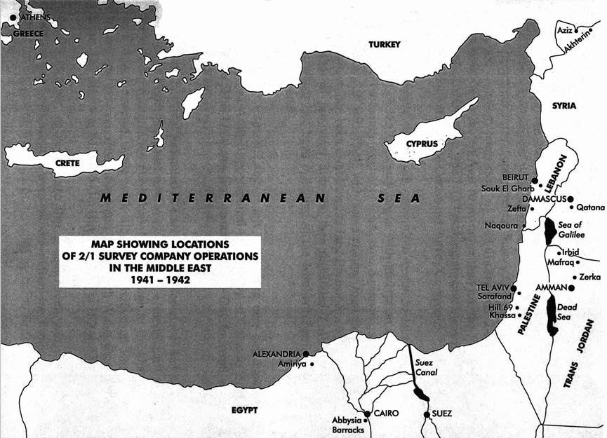
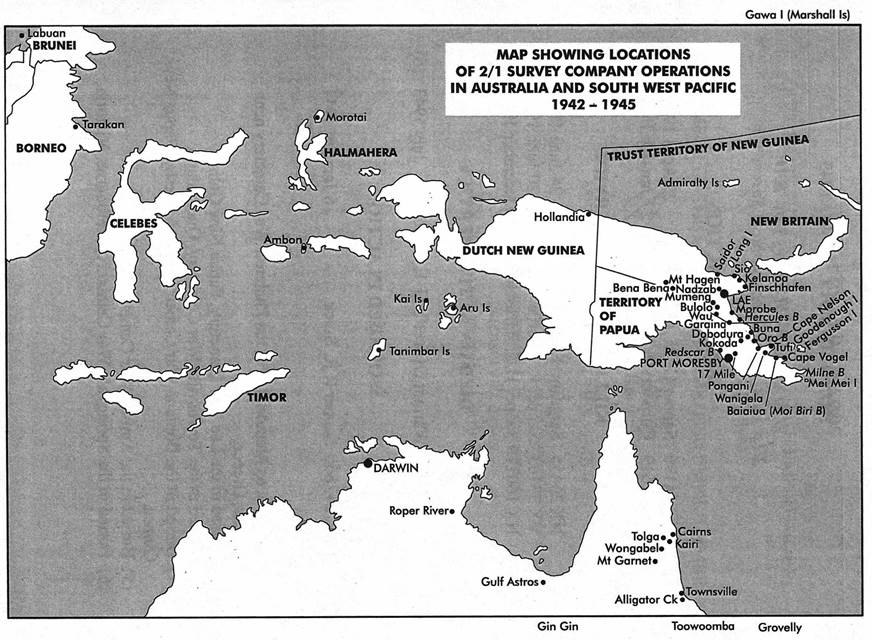
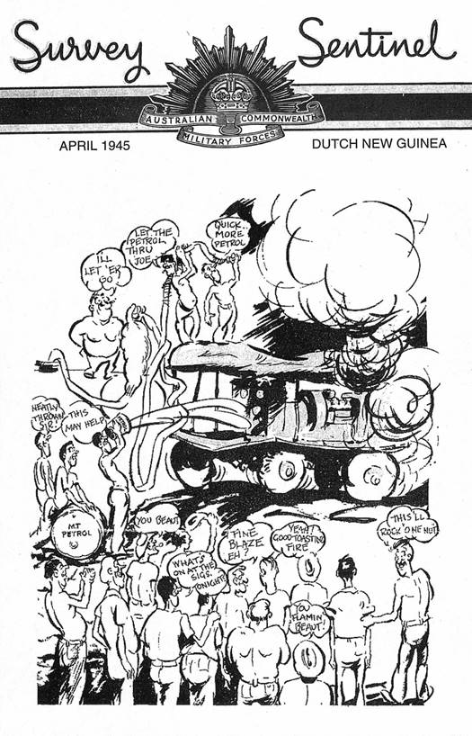
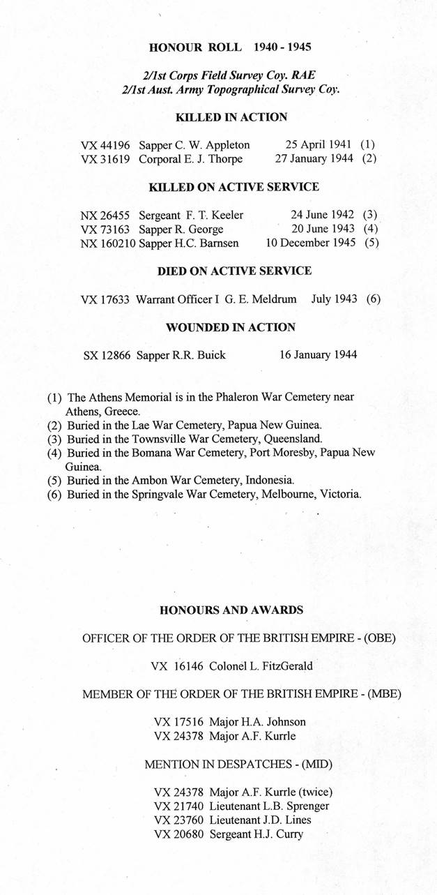
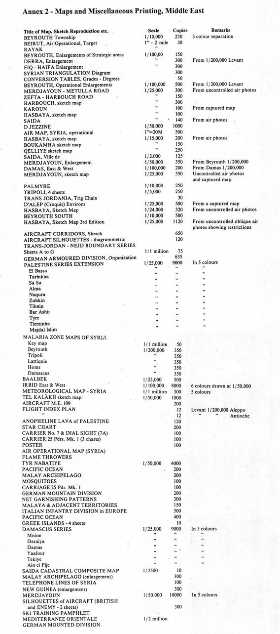
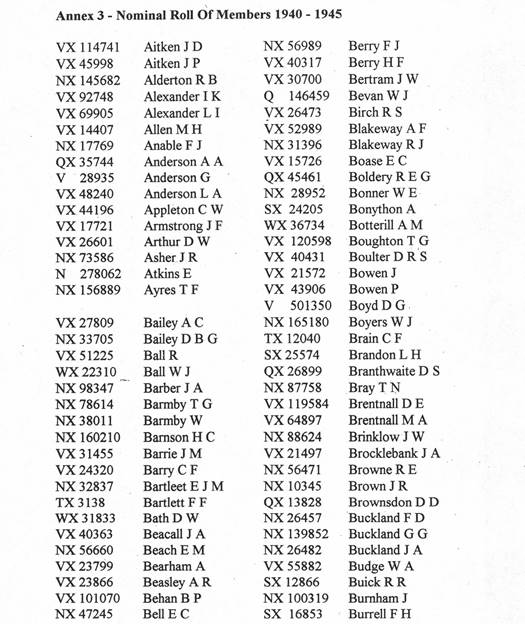
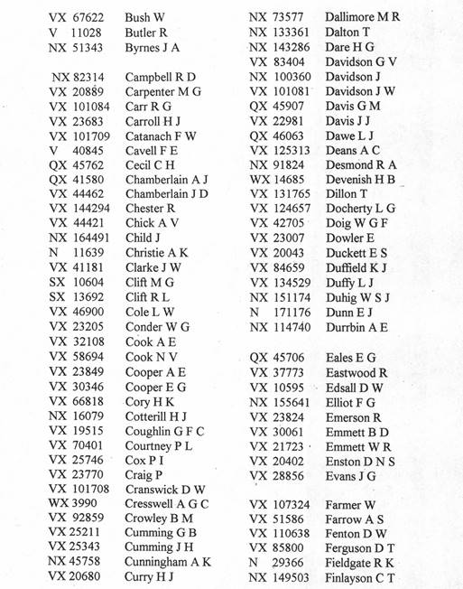
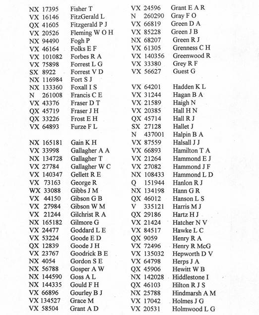
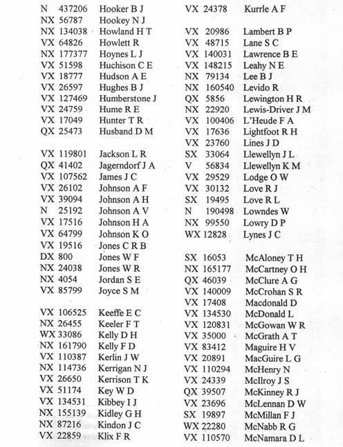
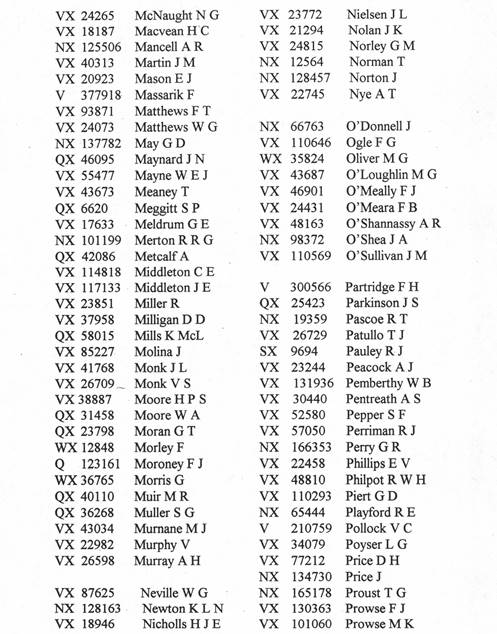
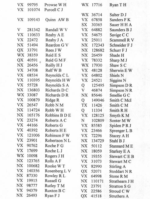
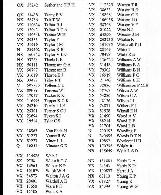
MAPS IN ALL SEASONS
A Concise History of the 2/1st Corps Field Survey Company RAE, and
2/1st Aust. Army Topographical Survey Company 1940-1945
First published 1999 by 2/1st Survey Association
39 Church Street, Beaumaris 3193
ISBN 0 646 35897 9
Printed in Australia by
Art Offset Printing
959 Glenhuntly Road
CAULFIELD SOUTH 3162
NL, BO17, 223799
29-7-99