Robert Lewis John Ellery
and the
Geodetic Survey of Victoria
from the Print Media
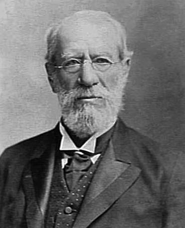
Robert Lewis John Ellery (1827-1908)
(courtesy State Library of Victoria, H24338)
Compiled by Paul Wise, August, 2020
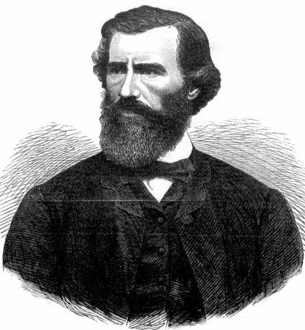
Ellery : from the Illustrated Australian News for Home Readers (Melbourne), Saturday 25 April 1868, page 4
Introduction
“Of course when I [Watson] first knew him [Ellery] he resided at the top of Bourke street. That was in 1853 - before he came to Williamstown. He had a brass plate on his door - Dr Ellery - at that time. He was a wonderful man. He was a carpenter, joiner, could act as a doctor - turn his hand to anything."
Turning to colonial historical record, we find that Robert Lewis John Ellery, CMG, FRS, FRAS, was born at Cranleigh, Surrey, England, in July 1827. His father was Dr John Ellery. He likewise was educated for the medical profession. Tempted to come to Australia by the discovery of gold he landed here in 1851 (sic). During that year he came under the notice of Governor La Trobe. It appears that the deceased astronomer had, before leaving England, made the acquaintance of the officials at Greenwich Observatory. At that institution he had learned a skilful use of the instruments. While practising his medical profession he wrote to the newspapers on the necessity of establishing a small nautical observatory at Williamstown. At that time Hobson's Bay became rapidly crowded with shipping [due to the Victorian Gold Rush]. So crowded, indeed, did it become that the masters of vessels could not even "get a horizon." Thus, navigation was hampered in the fact that proper provision had not been made for the precise determination of time. His suggestions bore fruit, Governor La Trobe commissioned him to establish the observatory. Its relics are to be seen in the Point Gellibrand lighthouse at the shore end of the local breakwater, by the fall of whose time ball at 1 pm. daily (regulated from the Melbourne Observatory since 1863) Captain Watson and a score of old identities invariably regulated their watches.
In 1853 Mr Ellery was appointed Government astronomer. A geodetic and trigonometrical survey of Victoria was initiated by him, Williamstown being the starting point. In 1863 the Observatory was removed to Melbourne. With it was amalgamated a meteorological and magnetic observatory, with which a Dr. Neumayer, of Bavaria, was associated. This was in 1858. In its original form the Williamstown Observatory was possessed of only a few small instruments for the determination of time, the distribution of time signals; and the rating of chronometers. At that time Mr Ellery combined his Government astronomer-ship with that of local marine depot storekeeper. As his first official work progressed, he gained a scientific reputation, and in 1856 established the Royal Society of Victoria, of which he remained president until 1884. The geodetic survey above referred to lasted from 1856 to 1874. For many years he was a member of the Melbourne University Council, a trustee of the Public Library, the lieutenant-colonel of the Submarine Mining Engineers (a corps which he had formed), and his interest in military matters never flagged. In the Observatory in the Botanical Gardens he laboured for 32 years, making a total of 42 years in the Government service. The Melbourne Observatory will compare favourably with any of the observatories of the world, and excels them in the feature that up to a certain date it possessed the largest telescope in the world, to procure which the Legislature granted the sum of £10,000. Mr. Ellery retired from its active control in 1896.
As in the above report, it is for his astronomical work that Ellery is mainly remembered; his crucial survey work is either glossed over or seen as part of his role as a public servant. It is the aim of this paper to highlight Ellery’s significant role in the Geodetic Survey of Victoria as evidenced by reports in the print media of the time.
Superintendent of the Observatory and Victorian Government Astronomer
Ellery became associated with the Geodetic Survey of Victoria through his role as then Government Astronomer. His role as Government Astronomer came about as mentioned above, through his letter To the Editor of The Argus of 3 May 1853, published on page 9 of the newspaper on Saturday 7 May 1853. The letter had his address as within the then Melbourne CBD indicating that Ellery was probably still conducting his medical practice at the time. The letter was as follows :
TIME.
To the Editor of the Argus.
Melbourne, 3rd May [1853].
Sir, - Having seen in your Journal some days back, a letter speaking of a "time ball" for the better regulation of the City time etc., I am induced to offer a few remarks from being intimately acquainted with the benefit derived, where any such signal has been erected, more especially at the Greenwich Observatory, for during much time spent there I have had ample opportunity of witnessing, I might almost say "necessity", of such a signal in a large commercial port. A time ball, such as at Greenwich or at St. Helena, well conducted, becomes an easy and certain method for mariners to rate and test their chronometers, - a most important point in a port like this, from which crowds of vessels are daily sailing.
The safety of every vessel on voyages depends in a great measure on the accuracy of its chronometers, and no master of a vessel ever let’s slip an opportunity of testing their truth. A time ball gives them an opportunity of doing this daily, as long as in port, and to do so with great accuracy. The use of such a signal to the inhabitants of the city itself, cannot be disputed, especially when we see the irregularity of public clocks.
A time ball, on the same principle as at Greenwich, might be erected at a cost which, compared to the advantages to be derived, would be very trifling. The simple though beautiful contrivance by which the rise and accurate instantaneous descent of the ball is insured, would be inexpensive even in this colony, and the observatory which would be necessary, either a transit instrument or a good sextant, and artificial horizon and an astronomical clock or good chronometer, and withal a careful observer. Surely so great a benefit at so small an undertaking is worthy of public attention.
I have the honour to remain,
Your most obedient servant,
ROBERT L.J. ELLERY.
149 Little Lonsdale Street, West.
In his letter Ellery contended that the then volume of shipping departing the Melbourne port area around Williamstown had no means of adjusting their chronometers vital to accurate navigation. Further, establishing a timeball (also time ball) to provide such a service initially only needed some basic equipment (a timeball consisted of a large, painted wooden or metal ball, able to move up and down a central column, that was dropped from the top of the column at a predetermined and publicised time. The timeball mast/tower was as high as possible to give best visibility to those who needed to view it). In addition to the timeball mechanism, astronomical observational equipment was required to obtain solar noon and a reliable chronometer to set and maintain local time. After observing solar noon and adjusting the local chronometer, at 1PM the timeball was usually dropped providing an instantaneous signal of that being local time; if the drop failed at 1PM it was usually repeated 15 minutes later.
Charles Joseph La Trobe (1801-1875), appointed in 1839 as superintendent of the Port Phillip District of New South Wales was now the first Lieutenant Governor of the colony of Victoria. La Trobe saw merit in Ellery’s idea and had established a time signal facility at the existing naval depot and signal station at Point Gellibrand. The timeball was set up on the flagstaff.
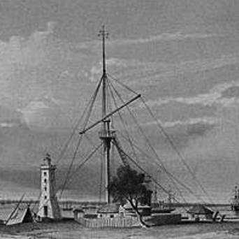
Figure 1 : Timeball flagstaff and lighthouse at Point Gellibrand, Williamstown, 1853 (courtesy State Library of Victoria)
In May 1853, Pownall Pellow Cotter, a ship sailing master, was appointed to organise and supervise the time signal service. Cotter had acted as the sailing master of HMS Terror during Captain James Clark Ross’s (1800-1862) magnetic expedition for the British Admiralty to study the global magnetic field and to establish a chain of magnetic observatories in British colonies. Cotter had settled in Melbourne and was in charge of the naval depot at Williamstown. When, after several weeks, minimal progress had been made with establishing the time signal service Governor La Trobe appointed Ellery in Cotter’s place. The first public timeball drop from the flagstaff came in August 1853. Cotter resigned soon after. A few months later, however, before the time signal was fully operational Ellery was appointed to supervise the time signal and to make the necessary observations (Andropoulos, 2014),
As Superintendent of the Williamstown Observatory, Ellery was given a small two-roomed wooden cottage at Point Gellibrand, close to the timeball flagstaff, as can be seen in Figure 1 above. Attached to the cottage was a small room for an observatory. The astronomical instruments included two sextants of indifferent quality, a small artificial horizon and two sufficiently reliable chronometers. More equipment was purchased in August 1853 and, with these new instruments, Ellery was able to provide the time signals more accurately.
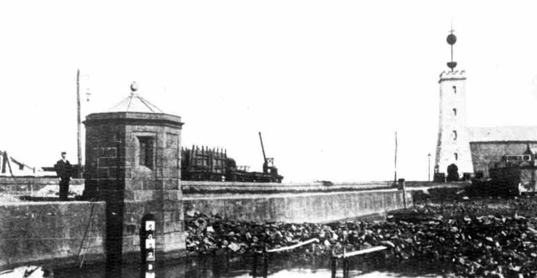
Figure 2 : (Right) Timeball on lighthouse at Point Gellibrand, Williamstown, 1909;
(Left) Tide gauge recording facility (Australasian newspaper of Saturday 20 February 1909, page 34)
A skeleton timber framed lighthouse on a stone foundation had been erected on the Point in 1839. In 1840 a flagstaff was erected just to the west which could be sighted from Flagstaff Hill in Melbourne and signalled shipping movements. This flagstaff later accommodated the timeball. The building of a new square bluestone lighthouse tower, with keeper’s quarters, occurred in the 1850s. The first telegraph line in Australia was installed between Melbourne and a station under the flagstaff in 1854. One of its main functions was to transmit the time signal to (and later from) Melbourne more reliably. The timeball was moved to the tower of the new telegraph office in Morris Street Williamstown from 1855, until the lighthouse was converted to take a timeball apparatus in 1861, where it operated until 1926. Please refer to Figure 2 above. Between 1854 and 1861, the keeper at the lighthouse would obscure the light at 2 minutes to 8PM then show the light at exactly 8PM to indicate local time. This additional signal service came in response to ship’s masters complaining about the visibility of the timeball. Please refer to Figure 3 below.
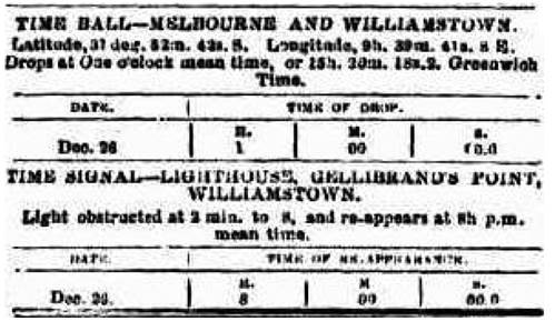
Figure 3 : Timeball and light signal services for Point Gellibrand, Williamstown, 1855;
(Age newspaper of Thursday 27 December 1855, page 5)
The Melbourne-Williamstown Railway came into operation in 1859. The Government Railway Workshops were built from 1857 between Williamstown and the Railway and Breakwater Piers. The advent of the railway and its proximity to the Williamstown Observatory saw the need for a new site for a Melbourne Observatory investigated, removed from the atmospheric and mechanical pollution of Williamstown. Eleven sites were assessed being :
|
1 |
Absolute House |
at the Flagstaff Observatory; also known as the Magnetical Observatory run by Professor Georg Balthazar von Neumayer (1826–1909). |
|
2 |
Sandridge |
near the battery, and nearly on the magnetic meridian of the Flagstaff Observatory and close to the beach. |
|
3 |
Botanical Garden Reserve |
A hundred yards towards the west of the newly erected Botanical Museum. First rate foundations; admitting of a free sight around the horizon with the exception of those points between E. and N.E. |
|
4 |
Toorak – Hawthorn |
seventy yards from the Glenferry Road on the eastern side. |
|
5 |
University |
between the yard of the University and the New Cemetery, some 120 yards from Madeline street towards the west. |
|
6 |
Royal Park |
on an open place some 207 yards towards the west of the late Observatory of the Geodetic Survey. Free sight around the horizon with the exception of from S.E. to N.E. |
|
7 |
Moonee Ponds |
some 200 feet from the road towards east, near the late Observatory of the Geodetic Survey. |
|
8 |
North Melbourne |
Stanley Street West, on a small hill. |
|
9 |
Footscray |
near the road from Melbourne to Williamstown, towards east. |
|
10 |
Williamstown |
near the newly erected Mechanics' Institute, some 400 yards from the railroad towards N.E. |
|
11 |
Red Bluff |
near the Trigonometrical Signal. |
before the Botanical Garden Reserve (3 in the above table) site was selected and the new Melbourne Observatory opened in 1863 (Victorian Parliamentary Papers, 1860).
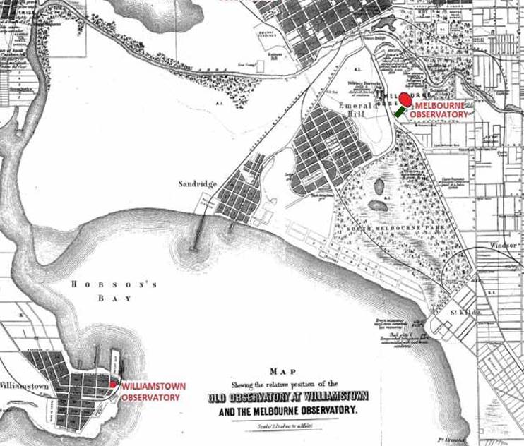
So as not to lose some ten years of observations establishing the longitude and hence time at Williamstown, a small triangulation was observed between the Williamstown and new Melbourne observatories. Please refer to Figure 4 below. The triangulation found that the difference in longitude between Williamstown and Melbourne was 4.0 minutes of arc. Thus, the longitude of the new Melbourne observatory was calculated to be 16.0 seconds of time greater than that of Williamstown. It is recorded that with the establishment of the Melbourne Observatory, Ellery also set out a baseline of 100 feet to enable the Surveyor’s 66 feet/100 link and Engineer’s 100 feet chains, to be accurately calibrated. The observations for this baseline were performed by Ellery in 1892-3. Terminal coordinates were also found for an Observatory baseline. This baseline was 750.3 feet (228.7 meters) long and ran approximately north-east to south-west to the west of the Observatory in the Botanic Gardens and outside the Observatory precinct. It is uncertain if this baseline was part of the control for the Williamstown-Melbourne Observatory triangulation but the baseline was certainly not part of the survey control for the construction of the Shrine of Remembrance and was destroyed when the Shrine was built and surroundings landscaped.
With the creation of Melbourne Observatory in 1863, Ellery was appointed Government Astronomer, a position he would retain until his retirement in 1895.
Surveying of Port Phillip and later Colonial Victoria
Prior to Ellery becoming involved with any land surveys in Victoria, such surveys had had a chequered history. Around 1838, what was to become Victoria, was known as the Southern or Port Phillip District of New South Wales. The then Governor of New South Wales, Sir Richard Bourke (1777-1855), found that his essentially Sydney based surveyors were unwilling to work so far away and work in that region. Towards the end of 1838, in an endeavour to have the work speeded up, the Governor invited tenders from persons willing to Contract for the survey of Crown land in the Port Phillip District for the year 1838. The salaried men of the Survey Department were given the right to tender, subject to discontinuance of salary during the Contract. The establishment of Victoria in 1851 had no real impact on the quality of land survey, in fact the discovery of gold around this time led to more sporadic and isolated surveys.
In the early years of colonial Victoria, Robert Hoddle (1794–1881) was the first Surveyor General of Victoria from 1851 to 1853. He was followed by Captain Andrew Clarke (later Lieutenant General Sir Andrew Clarke, GCMG CB CIE [1824–1902]). During Clarke’s term as Surveyor general, 1853 to 1857, he pointed out to the Government the growing requirement for a general and systematic survey of the colony, not only to assist in meeting the overwhelming demands for lands for settlement, but also with the view of tying together the numerous small separate surveys already dotted over the country. A small party of sappers and miners, who had been engaged in the Ordnance Survey of Great Britain, were subsequently obtained from the Imperial Government; a sergeant, two corporals and four sappers. Soon after their arrival they were placed in charge of parties of labourers and woodcutters to clear and erect trigonometrical stations on many of our most prominent mountain tops - notably Mount Macedon, Mount Disappointment, Mount Dandenong, Mount Eliza, Mount Martha, Arthur's Seat, Station Peak, etc., and subsequently many of the mountain peaks and hills in the Western district. Unfortunately such activity did little to solve the mounting survey predicament.
Ellery (1888) observed : There were, however, already signs that the system, or rather want of system, upon which the surveys of the lands of the colony had hitherto been carried out, was leading up to future trouble in consequence of overlapping boundaries and conflicting descriptions of adjacent limits of surveys, and to other evils inherent in a mode of laying out lands in isolated blocks without any relation or connection one to another, except in so far as the boundaries frequently ran north and south or east and west. It became, therefore, a matter of extreme importance, if not absolute necessity, in the further prosecution of the survey, to initiate a system that would obviate as far as possible any further trouble in this direction, and supply to some extent a remedy for the difficulties already existing, as well as expedite the subdivision survey for settlement.
Such was the situation when in 1858, Charles Whybrow Ligar (1811-1881), was appointed Surveyor General of Victoria. Ligar came with the expertise gained from being with the British Ordnance Survey and Surveyor General of New Zealand and was recruited primarily to reform the Victorian survey system. Ligar promised to reduce the cost of survey and open the land quickly for settlement. His plan for a geodetic survey was adopted in September 1858, a great improvement on the former magnetic surveys which were unreliable as legal documents and inadequate as a foundation for planning the expansion of settlement. The new survey of so-called Geodetic Squares, adhered strictly to the true meridians and parallels, and despite much criticism provided an accurate framework for progressing local surveys. Ligar's initial proposal, to replace the entire staff of government surveyors by contractors, was however not so popular, and because his promises to reduce expenditure and speed the surveys were not fulfilled by 1869, prominent politicians were demanding his removal. He resigned in September 1869.
The Argus newspaper of Saturday 5 February 1859, published on its page 5, the report of Surveyor General Ligar, dated 2 February 1859, on his proposed geodetic system or survey for 1859. This report had been tabled in the Victorian Legislative Assembly the previous night and is reproduced at this link.
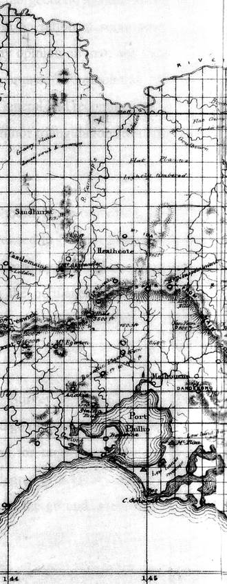
Figure 5 : Section of Ligar’s plan of 30 January 1860 showing the then location of the then meridian at 145 east across Victoria and his geodetic square layout.
When initiated in 1858, Ellery, as part of his role as Superintendent of the Melbourne Astronomical Observatory, was given carriage of Ligar’s Geodetic Survey. Mid September 1858, saw the determination by triangulation of the difference of longitude between the Williamstown Observatory and a point selected in the Royal Park, to the north west of the Melbourne CBD, as the starting point of the first chief meridian. This chief meridian was at longitude 145 degrees east and was selected as it was then within two miles of the Williamstown Observatory. The Supplement to the Victoria Government Gazette of Friday, March 1, 1861, published the position of (Williamstown Timeball) tower as 37° 52' 08" S, 144° 58' 30" E (9h 39m 54s) meaning the meridian at 145° east would be 1.5 minutes of arc further east or around 8 000 feet (5 280 feet in a mile).(It is important to note that changes in the local and worldwide establishment of longitude means that these values are no longer correct.)
The two mile baseline for the initial triangulation from Williamstown to Royal Park was measured on the rails of the Williamstown and Melbourne Railway with a standard [100 link/66 feet] chain. The meridian was then traced, cleared, and measured; the frequency with which observations at intermediate points were taken indicated that in the first forty miles of the line, the error of deviation from the true meridian was less than one inch. March 1859, saw the measurement of the first standard parallel (37° 48’ S latitude at that time) starting from the first chief meridian near Flemington. The chief meridian was then extended as far as 37° S latitude (at that time near Puckapunyal) and subsequently to the Murray (please refer to Figure 5 above), based on astronomical observations and checked by careful triangulation, to fix the geographical position of Mounts Macedon and Warrenheip, along with the intersection at 37° S/144° E (then near Maryborough). A most careful chain of triangulation was also carried along the parallels to fix the intersections of the secondary meridians.
It soon became evident that connecting distant localities with the chief meridian by running and measuring meridians through great expanses of country not required for survey was not cost-effective. Additionally the meridian/parallel intersections often occurred in very awkward places, on precipices, or in gorges, swamps or streams. Ligar's reports to Parliament omitted to differentiate that in the comparisons between Geodetic Survey and Trigonometrical Survey, one important advantage of the Trigonometrical Survey is that its fixed points could be chosen in the most convenient positions for observation!
When, in 1860, the work of defining meridian and parallel lines was abandoned in favour of the traditional triangulation Ellery seized the opportunity to standardise the geodetic triangulation of Victoria. He was already aware and acknowledged the earlier work under Clarke where trigonometrical points had been erected on prominent hills northwards from Melbourne to the Murray, and a considerable number in the Western District also, which had involved a great amount of labour and cost in clearing mountain tops and so on. Thus with a suitable base line measured, which could be connected into the existing network of established trigonometrical points, angular observations could be commenced immediately and progressed rapidly.
The fixing of the datum point for the baseline on Werribee Plains was a cause for some celebration going by the article which read : GEODETIC SURVEY.-The Geelong Advertiser [newspaper of Saturday 7 January 1860, page 2] His Excellency the Governor, [Sir Henry Barkly, KCB (1815–1898)], accompanied by the Chief Secretary [William Clark Haines (1810-1866)], the President of Land and Works, the Postmaster-General, Captain Pasley, the Surveyor-General, [Charles Whybrow Ligar (1811-1881)] and several other gentlemen, proceeded to Wyndham, for the purpose of fixing a datum or starting-point for the commencement of the geodetic survey. The company left the train at the Surveyor's Camp, about a mile on this side of the Werribee, where the initiatory rite was performed, as we believe, in a most satisfactory manner. A considerable stock of creature comforts accompanied the distinguished travellers, and, as we understand, the sparkling glass went its merry merry round in honour of the occasion. His Excellency and party returned to Melbourne by the last train.
Ellery, with a party of eleven men, measured the baseline on the Werribee Plains some 30 kilometres south west of Melbourne between January and May 1860. The actual measurement was done with three iron bars nominally ten feet (120 inches) long and one inch square, fitted with levels, thermometers and aligning vanes. Other items of equipment were trestles of varying heights fitted with instruments to facilitate their levelling and alignment when supporting the bars. Easily transportable tents nine feet high were used to cover the bars to prevent exposure to sun or rain during measurement. The southern end of the baseline was a point on the Melbourne to Geelong railway reserve, about 2 miles east of the Werribee railway station. The baseline extended 26 091.826 feet, or 4 941.16 miles to a point in direct line with Green Hill (today Eynesbury) on the western side of the Werribee River. Please refer to Figure 7 below. Over 2 000 observations were made in the process of determining the length of the baseline. The measured base was subsequently extended by a basenet, a further 5.651 miles to Green Hill, its total length then being 55 931.65 feet or 10.593 miles.. The north and south ends of the measured baseline were permanently marked with sunken masonry piers, having in their upper surfaces a piece of brass carrying a platinum dot indicating the termini of the measure. These marks were then covered with heavy cap stones. Please refer to Figure 8 below. The mark at the end of the extension to the north, on Green Hill, consists of a sunken bluestone block with a projecting iron spike. A remeasurement of the southern 11 174.29 feet (2.11 miles) with the bars following the general inclination of the ground instead of being level as during the first measurement, was also undertaken. A difference of only 0.308 inches or about 0.15 inches per mile (better than 2 millimetres per kilometre) was recorded.
Today’s determination of the Werribee baseline is 26091.923 feet, meaning Ellery’s measurement was within 2 millimetres in 5 kilometres.
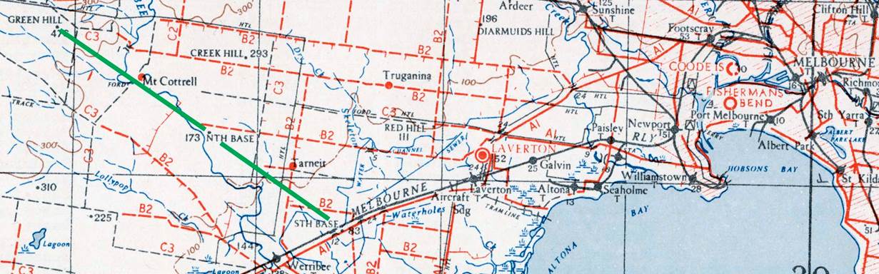
Figure 7 : Section of 1943 1: 253 440 scale SJ55-05 Melbourne map sheet showing the location of the Werribee baseline (green line); south base-north base-Green Hill.
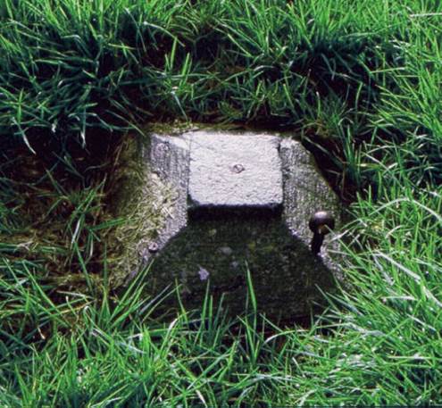
Figure 8 : Site of the South Base terminal at Werribee.
There is evidence that Ellery intended to remeasure the Werribee baseline with Colby type bars; a second measurement will shortly be commenced with some new rods, I have got made here - they are of Iron planed on the upper surface forming a compound bar…the iron and copper being permanently fixed together at one end, the other ends being free with marks for determining the expansion and interval between the rods. No physical verification of the rods or the remeasurement, however, have ever been found. (For the baseline for the triangulation of Ireland, Thomas Frederick Colby (1784-1852), devised a dual arrangement of brass and iron, which he called a compensation bar. The Colby compensation bar or just Colby bar, as his apparatus became known, was used for baseline measurements in all parts of the world, but were relatively expensive. Colby clamped together a bar of brass and a bar of iron both about 10 feet long. The central clamping meant any expansion/contraction of the materials due to temperature would occur at the extremities of the materials. As the two materials reacted differently to any expansion/contraction he was able to devise a method where two positions on the combined bars always remained 10 feet apart despite nominal temperature changes.)
Immediately on completion of the baseline, triangulation was extended over the whole of Victoria with the exception of the north western mallee section. On the extension of the primary triangulation westward to Mount Gambier and nearby Mount Schanck, in South Australia, Allan in July, 1864 reported that between these two mountains was an admirable site for a base of verification and that his proposed site was a much better one than that which had been selected for the Werribee Base. Allan recommended a length of 5.5 miles for the new base line. While the intention to measure a baseline of verification was agreed, the actual work, however, was never performed.
During the twelve years of the Victorian survey, 209 primary stations were established and observed. The whole area of the colony of Victoria, with one exception, Ellery observed in 1873, had been triangulated with a primary triangulation almost equal in accuracy to any in the world, from a baseline, which was measured with all the refinement, skill and instrumental means then available. Ellery continued, pressing for two base lines of verification; one on the western boundary of Victoria, and one in Gippsland, to close and verify the triangulation. The end of the Victorian triangulation came without either baseline being established, which would have been a great disappointment to Ellery, for there was no independent check on the work of his department. The quality of the Victorian triangulation was only revealed in the 1930s.
Four years after Ligar’s departure from the position of Surveyor General, the Argus newspaper of Monday 7 July 1873, published on its page 6, a report by Ellery as Superintendent of the Geodetic Survey. The report had been compiled in response to a request by the then Honourable James Joseph Casey (1831-1913) MP, Minister of Lands and Agriculture. Ellery’s report had been tabled in the Victorian Legislative Assembly on the night of Thursday 3 July 1873. night and is reproduced at this link below Ligar's earlier report.
Ellery gave details of The Survey of Victoria, (Ellery, 1888), and a Brief Sketch of the Geodetic Survey of Victoria, (Ellery, 1891). His 1891 paper provided a step by step account of the baseline measurement procedure.
Ellery’s Survey Legacy
During his lifetime Ellery was to never know the accuracy of the triangulation work undertaken under his leadership. As already mentioned above, neither of the two baselines of verification; one on the western boundary of Victoria, and one in Gippsland, were ever established.
The demarcation of the straight line, essentially from the source of the Murray River to Cape Howe, portion of the boundary between Victoria and New South Wales, in 1870 meant that the Victorian triangulation survey ranged north into southern New South Wales. Stations were established on Mount Pilot and Mount Kosciusko, and at Cape Howe. This triangulation work enabled the line now known as the Black-Allan Line, after Alexander Black (1827-1897) and Alexander Charles Allan (1831-1901) to be established as the border. When the New South Wales triangulation survey later reached that area the coordinates of several of the common triangulation stations were compared. The overall quarter of a second of arc difference in latitude and around 8 seconds of arc difference in longitude was then considered acceptable. The difference in longitude came from the fact that the longitude origin for the surveys came from independent observations at the Melbourne and Sydney observatories and until then the accuracy of one longitude determination against another had never occurred. When in the 1930s the Royal Australian Survey Corps began the process of producing the across-border, Albury 1: 63 360 (1 mile to 1 inch published in 1933) scale map sheet and this work could not proceed until a resolution to the mismatched coordinates problem had been found. An examination of the Victorian triangulation records found that in places this survey was not to a first order geodetic standard. A recomputation and rigorous adjustment of a series of well conditioned triangles through the Victorian triangulation network to the Werribee baseline was thus undertaken. The result of this work indicated that rather than the quality of the Victorian triangulation being at fault, the coordinate differences occurred; firstly, due to the Melbourne and Sydney Observatories being on independently obtained astronomical origins; and secondly because the respective colonies used different figures of the earth for their computations; New South Wales used Bessel (1841) while Victoria used Clarke (1858). Based on this work, in the future the geographic coordinates of the Sydney Observatory would be the origin for geographical coordinates for eastern Australia (this origin remained until the 1966 adoption of the Johnson Geodetic Origin), and Clarke's (1858) Figure of the Earth would be the common mathematical base for geodetic coordinates (Clarke (1858) was used until the Australian National Spheroid (ANS1966) was adopted in 1966).
Ellery thus left Victoria with a triangulation baseline measured with an accuracy meeting or exceeding world standards. The Victorian triangulation, while of variable quality, was capable of being adjusted to geodetic standard and being integrated into the national network initially with New South Wales.
Andropoulos, Jenny Ioanna (2014), Astronomical Publications of Melbourne Observatory, PhD thesis, James Cook University, accessed at : https://researchonline.jcu.edu.au/41296/1/41296-andropoulos-2014-thesis-volume-1.pdf
Anonymous (1852), Ship News, Cornwall Chronicle (Launceston), Saturday 13 November 1852, page 754, accessed at : https://trove.nla.gov.au/newspaper/article/65580856/6228481#
Anonymous (1860), Intercolonial News : Geodetic Survey, South Australian Advertiser (Adelaide), Monday 16 January 1860, page 3, accessed at : https://trove.nla.gov.au/newspaper/article/90250080/8356836
Anonymous (1865), Geodetic Survey, The Sydney Morning Herald, Thursday 28 December 1865, Page 2, accessed at : https://trove.nla.gov.au/newspaper/article/31126250?searchTerm=geodetic%20survey&searchLimits=l-format=Article|||l-title=35|||l-decade=186
Anonymous (1868), Robert Lewis John Ellery, FRAS , Illustrated Australian News for Home Readers (Melbourne), Saturday 25 April 1868, page 4, accessed at : https://trove.nla.gov.au/newspaper/page/5732388
Anonymous (1873), Geodetic Survey of Victoria, Age, Saturday 5 July 1873, Page 7, accessed at : https://trove.nla.gov.au/newspaper/article/202518786?searchTerm=trigonometrical%20base%20line&searchLimits=dateFrom=1850-01-01|||dateTo=1900-12-31|||l-advcategory=Article|||l-state=Victoria
Anonymous (1908), Astronomer RLJ Ellery : A Man of Many Parts : Interred at Williamstown, Williamstown Chronicle, Saturday 18 January 1908, Page 2, accessed at : https://trove.nla.gov.au/newspaper/article/69699734#
Benwell, George L (1987), The Victorian Geodetic Baseline, The Australian Surveyor, Vol.33, No.8, pp.751-775.
Chappel, Keith Lytton (1966), Surveying for Land Settlement in Victoria 1836-1960, Department of Lands and Surveys Victoria.
Commonwealth Government Handbook (1914), British Association for the Advancement of Science, (G.H. Knibbs, Ed.), Eighty-fourth Meeting, Australia, August 1914, AJ. Mullett, Government Printer. Melbourne.
Deakin, RE, Sheppard, SW and Ross, R (2011), The Black–Allan Line Revisited, Presented at the 24th Victorian Regional Survey Conference, Shepparton, 01-03 April, 2011, accessed at : http://www.mygeodesy.id.au/documents/Black-Allan%20Line%20Revisited.pdf
Ellery, Robert Lewis John (1853), Time, The Argus (Melbourne), Saturday 7 May 1853, page 9, accessed at : https://trove.nla.gov.au/newspaper/article/4792379?searchTerm=Ellery&searchLimits=dateFrom=1853-01-01|||dateTo=1853-12-31|||l-advstate=Victoria|||sortby=dateAsc|||l-title=13|||l-category=Article|||l-decade=185|||l-year=1853#
Ellery, Robert Lewis John (1888), The Survey of Victoria, Victoria and its Metropolis Past and Present, The Colony and its People in 1888, McCarron, Bird & Co., 1888, Vol. II, Chapter 1, pp.1-8.
Ellery, Robert Lewis John (1891), Brief Sketch of the Geodetic Survey of Victoria, Victorian Institute of Surveyors, pp.1-8.
FitzGerald, Lawrence (1933), The Co-Ordination of the Trigonometrical Surveys of Queensland, New South Wales, Victoria and South Australia, The Australian Surveyor, March 1934, pp.22-31.
Gascoigne, Sidney Charles Bartholomew (Ben) (1972), Ellery, Robert Lewis (1827–1908), Australian Dictionary of Biography, National Centre of Biography, Australian National University, accessed at : http://adb.anu.edu.au/biography/ellery-robert-lewis-3477
State Library of Victoria (2020), Victorian Immigration and Emigration, Unassisted migrants 1852-1923, accessed at : https://prov.vic.gov.au/explore-collection/explore-topic/passenger-records-and-immigration/unassisted-passenger-lists
Victorian Parliamentary Papers (1860), First Annual Report of the Board of Visitors to the Astronomical and Magnetical Observatories, VPARL1860-61, No.18.
Victorian Parliamentary Papers (1876), Eleventh Report of the Board of Visitors to the Melbourne Observatory, VPARL1876, No.31.
Newspaper Articles
|
Date & Link |