A Case Study of a Central Service Agency – the Australian Survey Office
(Originally authored by Collin (Col) Fuller, Senior Surveyor ASO, but edited before publication in the DAS Annual Report.
Thanks to Doug White et.al. for providing clarification on the Commonwealth Surveyor-General in the AUSLIG era.
Editor’s note : The photographs were not part of the original article and the tables have been expanded to complete the ASO history from inception to demise after AUSLIG was given a strong commercial focus. AUSLIG was required to implement full cost recovery from the outset, and major Commonwealth clients such as Defence, the Australian Bureau of Statistics and the Australian Antarctic Division were free to source their surveying and mapping services from other providers. The negative impact on AUSLIG’s commercial attempts by the bureaucratic overheads imposed to necessarily protect the ‘public purse’ eventually forced an end to its service role.)
Compared with the size and complexity of government activity in the 1980s, the picture of Federal Government which emerged from the Constitution in 1901 was small, simple and straightforward: a mere six departments were established to carry out what the fathers of Federation saw as appropriate Commonwealth functions; and a seventh, the Department of Home Affairs, to carry out a servicing role.
It was recognised early that surveying was an appropriate function for the servicing department. The Secretary of the Department, William John Lyne, wrote at the time:
It is a requisite that the whole of the survey operations (both field and office) carried out by the Commonwealth should be under the direction of an authority who would be responsible for and secure consistency throughout Australia not only of the actual surveys themselves but of the production of the original plans and their subsequent reproduction.
In this recognition of the necessity for federal co-ordination of survey activities throughout Australia lay the seeds for the growth of what has become the Australian Survey Office.
The development of the Survey Office took place in three broad periods; from Federation until World War II, World War II to 1970, and 1970 until the present. The first period was the birth, growth and regionalisation of the organisation; the second the expansion of Commonwealth functions following World War II and its impact on the Survey Office characterised by organisational change, growth and the application of technology developed during the war; and the third covers the consolidation and streamlining of the organisation with the application of modern technology to the work of the Survey Office.
|
|
|
|
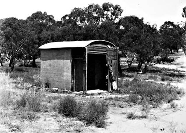
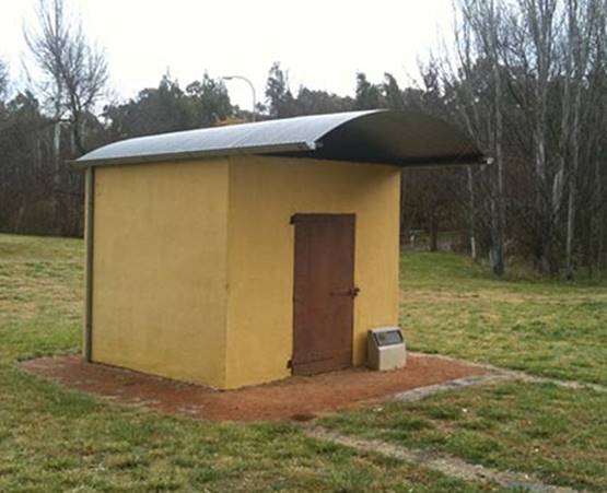
The first permanent structure in Canberra, the map and plan building (aka The Surveyor’s Hut), before and after restoration. |
|
Federation to World War II
Surveyors have been part of the history of Australia since its foundation. They were involved in exploration and the search for new lands for agriculture and grazing as a response to the Government of the day and also in setting out villages and townships, the connecting roads, locating and marking the water and timber reserves and other lands to be set aside for the Crown. Their reports on the quality and quantity of lands and other natural resources enabled the Government to meet the growing demand by the new settlers for land.
After Federation the need for an organisation to co-ordinate and control all aspects of surveying and mapping in Australia was recognised. To achieve this a number of functions were transferred from the States to the Commonwealth.
The Commonwealth's Lands Acquisition Act was promulgated in 1906 and a property officer position included in the establishment of the Department of Home Affairs in 1909. Late in 1910 the position of Director of Lands and Surveys was advertised and Mr C. R. Scrivener was appointed to it on 1 January 1911.
|
Commonwealth Surveyors-General |
|
|
C. R. Scrivener, I.S.O. |
1911-1915 |
|
Col. J. T. H. Goodwin, M.B.E. |
1915-1929 |
|
A. Percival, I.S.O. |
1929-1944 |
|
F. M. Johnston, J.P. |
1944-1949 |
|
J. N. C. Rogers, I.S.O. |
1949-1961 |
|
J. Boyle |
1961-1969 |
|
W. D. Kennedy, O.B.E. |
1969‑1983 |
|
J. W. Sleep |
1983-1988 |
|
G. K. Lindsay |
1988-1992 (AUSLIG) |
|
G. Bashford |
1992-1994 (AUSLIG) |
|
J. Kent |
1994-1996 (AUSLIG) |
|
P. Holland |
1996-2001 (AUSLIG) |
|
Editor’s note : Most of the functions of the Commonwealth Surveyor-General passed to the ACT when they achieved self-government in 1988. Nevertheless, from time to time in the following years, specific activities involving Commonwealth lands required Commonwealth oversight. As there was nothing in any of the legislation that prevented a non-surveyor holding the position of Commonwealth Surveyor-General the General Manager of AUSLIG (or his appointee) continued to undertake those necessary functions of the Commonwealth Surveyor-General until 2001. |
|
Mr Scrivener, then on loan from the N.S.W. Government, had established a survey camp in 1909 and returned in January 1910 to establish a permanent camp so that he could undertake a comprehensive survey for the location of a city within the Australian Capital Territory. The first permanent structure in Canberra was the map and plan building adjacent to the camp. This building is still standing on the western side of Capital Hill and has been declared an historic site. The surveyors and draftsmen brought to Canberra in 1910 became the nucleus of the Lands and Survey Branch which was formed under Mr Scrivener as Director.
|
Significant dates |
|
|
1901 |
Department of Home Affairs established. |
|
1910 |
Lands and Survey Branch established in Canberra. |
|
1911 |
Mr C. R. Scrivener, appointed Director 1 January. |
|
1912 |
Conference of Surveyors-General, Melbourne 20-25 May. |
|
1935 |
Commonwealth Survey Committee appointed by Cabinet, chaired by the Commonwealth Surveyor-General. |
|
1939 |
Establishment of survey and property offices in Perth, Adelaide and Brisbane. |
|
1945 |
Commonwealth Survey Committee and State Surveyors-General met 15-19 January - establishment of the National Mapping Council. Commonwealth Surveyor-General appointed Director of National Mapping. |
|
1951 |
Separation of the positions of Commonwealth Surveyor-General and Director of National Mapping. Transfer of Department of Civil Aviation survey group to Lands and Surveys Branch. |
|
1954 |
Cabinet Decision authorises a single authority for all geodetic and topographic surveys and mapping within the Department of the Interior. |
|
1956 |
Prime Minister announces the transfer of the National Mapping function to the Department of National Development, 24 May. |
|
1963 |
Separate Property and Survey Branches created within the Department of the Interior. |
|
1972 |
Transfer of Northern Territory Survey Section to the Survey Branch. |
|
1976 |
Review of Commonwealth Government Administration. |
|
1978 |
Major proportion of Northern Territory personnel transferred to the Northern Territory Government. |
|
1981 |
Review of Commonwealth Functions (RCF) - increased use to be made of private sector surveying services. Review of survey and mapping organisations established by the RCF confirms role of Australian Survey Office. Commonwealth Co-ordinating Group on Mapping Charting and Surveying established. |
|
1986 |
The National Mapping Council was dissolved and replaced by the Intergovernmental Committee on Surveying and Mapping. |
|
1987 |
Under the Administrative Arrangements Order of 24 July 1987, National Mapping was subsumed within the Australian Survey Office becoming AUSLIG (The Australian Surveying and Land Information Group). |
|
2001 |
Geoscience Australia formed with the Australian Surveying and Land Information Group (AUSLIG) merged with the Australian Geological Survey Organisation (AGSO). |
|
|
|
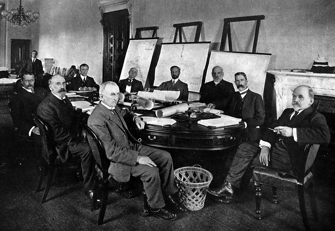
Conference of Commonwealth and State’s Surveyor’s-General - Melbourne, May, 1912 Anti-clockwise round the table from gentleman nearest camera facing left Joseph Martin Reed Surveyor-General Victoria and Chairman Charles Robert Scrivener Director of Commonwealth Lands and Surveys. James Mackenzie Surveyor-General New Zealand Charles Edward Adams Government Astronomer New Zealand Edwin Mitchell Smith Surveyor-General South Australia H.E. Finney Secretary C. Seddon Clerk Allan Alfred Spowers Surveyor-General Queensland Frederick Poate Surveyor-General New South Wales Edward Albert Counsel Surveyor-General Tasmania |
A wide range of survey work on projects of federal interest was undertaken throughout the continent. Work associated with development of the national capital was one of the most important and continuing projects undertaken by departmental surveyors. The formation of the Federal Capital Commission in 1925 gave an increased impetus to this work. During its six-year life span the Commission produced a number of lasting memorials including Parliament House and West Block.
Topographic mapping as a Commonwealth responsibility first became a major concern of the Branch in 1921.
Although many of the staff of the Branch were dismissed during the depression and some transferred to other Commonwealth departments, the organisation continued to develop. In 1935 a Commonwealth Survey Committee, chaired by the Commonwealth Surveyor-General, was appointed by Cabinet in response to a need for accurate maps and the co-ordination of surveys. By 1939 there was a need to establish offices in Perth, Adelaide and Brisbane. During World War II the functions of the Commonwealth Government increased substantially in a number of areas. The Lands and Survey Branch, in turn, saw an increase in demand for its services, particularly in relation to defence installations, aerodromes and mapping.
Development 1945-1970
During the post World War II period the work program of the Survey Office increased to such an extent that it led to a separation of the property, mapping and surveying functions. A major part of this increase resulted from the requirement, commencing in 1947, for survey work at Woomera in South Australia. Surveying services for the establishment of the weapons system trial area were initially provided on an 'as needed' basis but eventually led to the establishment of an office there between 1953 and 1973. Staff numbers at Woomera peaked at 36 in 1957. Like Canberra, what began as a permanent camp site with staff under canvas eventually developed into a township.
Following discussions with the States in 1945, a National Mapping Council was established and the Surveyor-General appointed Director. The Council was formed as an advisory body to all governments to co-ordinate series mapping on a voluntary basis.
In 1950, the Property and Survey functions were formally separated into two sections under one branch head. This left a Survey Office with a clearer functional unity and led in the following years to the consolidation of the survey groups which had emerged in some Commonwealth departments during the war and immediate post-war years, as the value of a central surveying organisation, advocated soon after Federation, was again recognised. The Survey Office assumed responsibility for undertaking the engineering work for the then Department of Works and Civil Aviation with a gradual handing over of staff and projects.
In 1951, the Director of National Mapping was created as a separate position from the Surveyor-General.
In 1956 the mapping function was transferred to the then Department of National Development, although the Survey Office retained responsibility for large scale mapping of the Territories.
In 1957 when the National Capital Development Commission (NCDC) was established with its charter to plan and construct the National Capital, a reorganisation was made of the functions of the Department of the Interior. Town planning went to the NCDC. The NCDC and the Property function of the Department of the Interior became two of the Survey Office's major users.
Many of the technologies developed during the war for military purposes were adapted for civilian use. The application of photogrammetry, the use of photography in survey work, increased significantly and electronic distance measuring equipment (EDM), which enables measurements to be made with great accuracy over long distances, was developed from radar. First used by the Survey Office at Woomera to consolidate the survey control network, EDM was later taken up by the Canberra Office to extend and intensify the control network of the A.C.T.
|
Administrative Arrangements |
||
|
Date |
Department |
Remarks and instrument |
|
1901 |
Home Affairs |
Created at Federation Gazette No.1, 1 January 1901 |
|
1916 |
Home and Territories |
New Department created Gazette No. 188, 21 December 1916 |
|
1925 |
Works and Railways |
Transfer notified in Gazette No. 94, 5 November 1925 |
|
1932 |
Interior |
New Department created Gazette No. 33, 14 April 1932 Administrative Arrangements notified Gazette No. 35, 14 April 1932 |
|
1972 |
Services and Property |
New Department created Gazette No. 129A, 19 December 1972 Administrative Arrangements notified Gazette No. 131, 20 December 1972 |
|
1975 |
Urban and Regional Development |
Transfer notified in Gazette No. S200, 7 October 1975 |
|
1975 |
Administrative Services |
New Department created, Gazette No. S262, 22 December 1975 |
|
2001 |
Resources, Energy and Tourism |
Geoscience Australia formed |
The increased interest in mineral exploration during the post-war period also involved the Survey Office: it was requested in 1950 to assist the Bureau of Mineral Resources (BMR) with survey control for the network of gravity measurements being planned across Australia, and later for surveys relating to seismic and geological work. By the late 1960s there were often up to 14 field parties on various activities for BMR around Australia and Papua New Guinea. Staff were also involved at this time, in marine surveys on the Australian Continental Shelf for BMR.
In 1962 the Survey Office acquired its first stereo-plotter, a machine used for compiling maps from aerial photography. Over the next few years equipment and manpower were increased and the aerial surveys and photogrammetry function consolidated. This represented a new direction in the development of the organisation. As the technology involved was capital intensive and specialised skills are required, the section was established as a central group within the Survey Office, servicing users through all regional offices.
The calculations necessary to support plotting on these instruments were extensive and the work was laboriously undertaken on hand-cranked or electric desk-top calculating machines. In 1961 the introduction of an electronic computer enabled this reduction of data to be performed more efficiently. In some cases the time required was reduced from days to hours. The Survey Office was the first survey organisation in Australia to install a computer. A few years later the Survey Office was again to the fore with the installation of a flat-bed automated plotter.
As noted earlier, the NCDC was set up to plan and develop. Canberra. The Survey Office became involved in the upsurge of activity in urban development and all its facets. The A.C.T. Office increased in the 1960s to some 60 surveyors and about 114 field assistants, together with drafting, clerical and other staff necessary to cope with the rapid development of Canberra. Utilisation of private sector resources was increased to cope with peak demands and has remained at a high level. During this period other important projects got underway throughout the A.C.T. including the Bendora and Corin Dams, the satellite-deep space tracking stations at Tidbinbilla, Orroral Valley and Honeysuckle Creek and a rural road improvement program.
The years 1965 through to 1970 saw the Office engaged in surveys for microwave links around Australia for what is now Telecom. The first survey from Adelaide to Perth was followed by the west coast link to Port Hedland. Almost simultaneously with the west coast link the Townsville-Mt Isa-Darwin project commenced. These jobs drew heavily on in-house resources and it was necessary to engage private survey firms to assist with other projects. The organisation then had offices in all mainland capitals and a branch office in Townsville. Staff were also located in Port Moresby to assist with surveys for airfields throughout the Territory of Papua New Guinea and in Darwin for airfields surveys in the Northern Territory.
In November 1967 the Surveyors Board of the Australian Capital Territory was constituted. The formation of this Board realised a recommendation made in 1912 by Mr C. R. Scrivener. The Board, under the chairmanship of the Surveyor-General, is responsible to the Minister for Territories and Local Government but the Secretariat is provided by the Department of Administrative Services through the Survey Office.
|
|
|
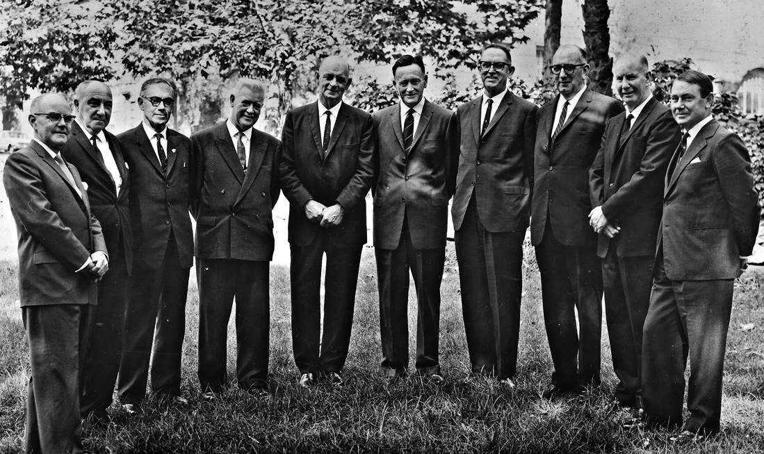
MEMBERS OF THE NATIONAL MAPPING COUNCIL 21st. MEETING AT SYDNEY - APRIL 1963 (Left to right) J. N. ROGERS COMMONWEALTH SURVEYOR-GENERAL F. W. ARTER SURVEYOR-GENERAL OF VICTORIA H. A. BAILEY SURVEYOR-GENERAL OF SOUTH AUSTRALIA F. MILES SURVEYOR-GENERAL OF TASMANIA C. E. ELPHINSTONE SURVEYOR-GENERAL OF NEW SOUTH WALES B. P. LAMBERT (CHAIRMAN) DIRECTOR OF NATIONAL MAPPING T. HEIN SURVEYOR-GENERAL OF QUEENSLAND COL. D. MACDONALD DIRECTOR OF MILITARY SURVEY H. CAMM SURVEYOR-GENERAL OF WESTERN AUSTRALIA CAPT. A. H. COOPER THE HYDROGRAPHER R. A. N. |
Challenges since 1970
The growth of the organisation to meet the increasing demands for surveying services by a. wide range of users resulted in a number of significant changes within the Survey Office during the 1970s, many of them prompted by the rapidly changing technology.
By the mid-1970s the development of expertise in the areas of computer applications to surveying and drafting, the use of aerial photography, technical investigation and appraisal of new equipment and technologies was well advanced. About this time a group of subject matter specialists was developed in the Systems Design Section. This shifted the emphasis in the work of the Section from the development of computer systems to the development of survey systems involving the collection, processing and output of survey data. Today this group is well placed to advise on the use and implementation of computer based modern technology in surveying.
The Melbourne Office established an outpost in Hobart to deal with increased Commonwealth survey requirements. The creation in 1971 of a Technical Services Section, later to become a Branch, was another major change.
Staff in the early 1970s assisted Commonwealth engineers engaged on overseas aid projects in Vietnam and various parts of Indonesia. A surveyor was outposted for some years to New Guinea on a hydroelectric scheme in the Ramu Valley. Another large aid project in which the Office was involved was the survey and subdivision of sugar lands in Fiji previously owned by the Colonial Sugar Refining Company.
Surveys over the last decade which required technical skills, expertise, ingenuity and initiative included the Black Mountain Tower in Canberra and the communications tunnel in Melbourne for Telecom; the Hermannsburg subdivision in the Northern Territory; Cockburn Sound development in Western Australia and the new international airport in Brisbane. Terrestrial photogrammetry was introduced to record buildings and sites, including rock art related to Australia's heritage; it has also been used for the defence industry.
The staffing restraints of the 1970s together with the labour intensive nature of surveying resulted in a greater use of technology and led to an improvement in productivity. The Review of Commonwealth Functions in 1981 initially accelerated the decline in staff numbers with the decision to allocate a greater proportion of survey work to the private sector. However, use of modern technology and of the private sector has enabled the Survey Office to continue to provide the level of service required by its users.
Concurrently new developments are being monitored for their potential application to the wide range of activities now undertaken by surveyors. An example is remote sensing, where a major technological development has recently been introduced. This incorporates analysis of satellite data and represents the state of the art in the world today. The satellite images are being used for the declaration and management of the Great Barrier Reef Marine Park. The techniques have far wider applications, including regional planning.
During the 1970s, too, the organisation was restructured to reflect the rapid changes in technology and provide the staff necessary for its assessment and use. For example, the upgrading of automated plotting facilities in 1974 reduced much of the manual drafting effort.
So that all sections of the Survey Office could have better access to many of the new technologies, a computer network was established. Commencing in 1981, most of the regional offices were equipped with a computer and automated drafting facilities similar to those installed in the Central Office. Automated plotters have made possibly the greatest single impact of any technology on drafting techniques.
Overview
The history of the development of the Survey Office reflects the changes in Commonwealth Government activities since Federation. From the early days of servicing a few Federal Departments, the Survey Office now provides a service to some 46 Commonwealth Departments and Authorities. The organisation has developed its capabilities from cadastral and engineering surveying to the point where it is able to arrange for the collection, interpretation and portrayal of a full range of information concerning the land and its attributes. The Commonwealth requires a surveying organisation in the 1980s that is no less dedicated to the execution of its duties than its counterpart of the early days of Federation, yet is more flexible and more responsive to the challenge of new technology and the increasing demand for information which are characteristics of this decade.