FIFTH UNITED NATIONS REGIONAL CONFERENCE
FOR ASIA AND THE FAR EAST
(Canberra, Australia, 8 March to 22 March 1967)
Item 6 of the provisional agenda
AIR PHOTOGRAPHY AND TOPOGRAPHIC MAPPING IN AUSTRALIA
by
B.P. Lambert,
Director of National Mapping,
Department of National Development,
Canberra, Australia
INTRODUCTION
The responsibility for the government of Australia is divided between the
1.
Commonwealth (Federal) Government and the six state governments.
Under the Constitution setting up the Federation, only certain specific powers were
2.
given to the Commonwealth Government and in all other respects the state governments have
sovereign powers.
No specific mandate was given to the Commonwealth in respect of mapping but the
3.
Commonwealth may, and does, undertake topographic mapping as an activity necessary for
the good government of the nation, for defence purposes, for civil aviation and to assist in
national development.
The states also undertake general topographic mapping for the good government of their
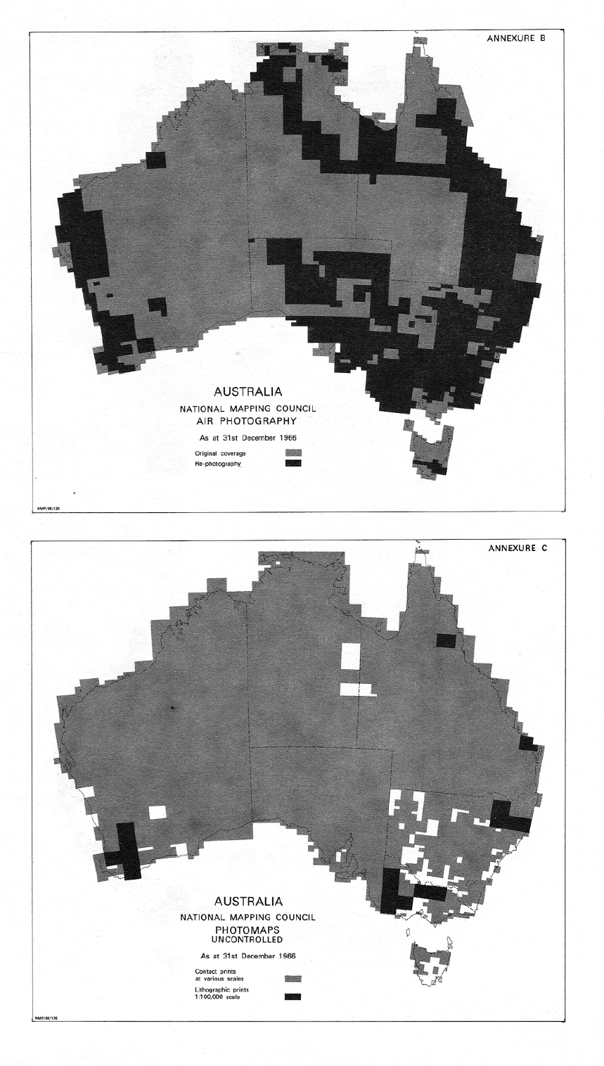
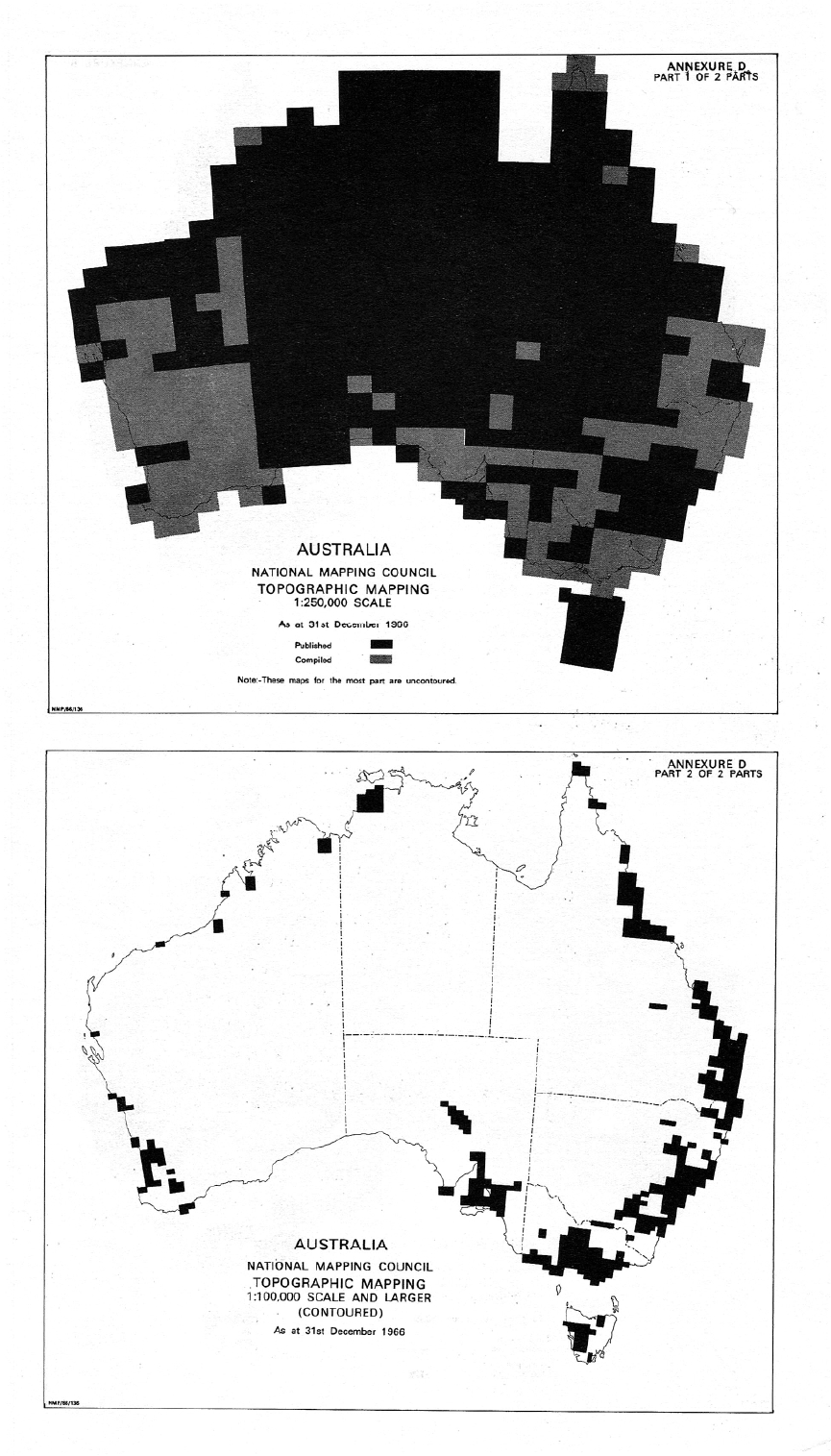
4.
territories and for specific administrative and developmental projects. The work is carried out by
the lands and survey departments under the respective state surveyors general.
A large amount of topographic mapping, at varying scales (mostly large-scale), is
5.
undertaken by photogrammetric mapping companies working on contracts from engineering
and mineral prospecting agencies and from governmental and semi-governmental authorities.
GOVERNMENTAL ORGANIZATION FOR MAPPING
By direction of the Commonwealth Government the Department of National
6.
Development has full responsibility for all geodetic surveys and topographic mapping required for
Commonwealth purposes and for the co-ordination of these activities with those of the states. The
Division of National Mapping is the organization within the Department that is charged with these
responsibilities.
Certain of the resources of the Royal Australian Army Survey Corps are applied to
7.
portions of the Commonwealth geodetic surveys and topographic mapping programme which
are allotted to it by the Department of National Development.
In 1945, the Prime Minister of the Commonwealth and the state premiers agreed to set
8.
up a National Mapping Council which would advise on standardization and co-ordination of
Commonwealth and state mapping activities.
The Director of National Mapping is Chairman of this Council and the following
9.
Commonwealth officers are members; the Hydrographer of the Royal Australian Navy, the
Director of Military Survey and the Commonwealth Surveyor General (Department of the
Interior).
Each state surveyor general is a member.
10.
It was, at the same time, agreed that the Director of National Mapping would be
11.
responsible for the co-ordination of the activities of Commonwealth and state authorities in
planning and carrying out the national mapping of Australia with full regard to the
recommendations of the National Mapping Council.
The Council meets once each year and has a technical sub-committee consisting of
12.
technical officers who meet six months before each meeting and discuss their technical work
in detail and report on technical matters specifically referred to them by the Council.
No formal dividing line has been agreed upon, or even suggested, between the
13.
Commonwealth and the states but in practice the states concentrate mainly on medium-scale
and large-scale mapping (1:31,680 and larger) and the Commonwealth concentrates on small-
scale and medium-scale mapping (mainly 1:1,000,000; 1:100,000 and occasionally 1:50,000
and 1:25,000).
The Commonwealth Department of the Interior is responsible for Commonwealth Land
14.
Boundary and Engineering Surveys, and in this capacity undertakes large-scale topographic
surveys particularly in connection with the development of Canberra as the national capital.
15. Some states have mapping advisory or co-ordinating committees and some have survey co-
ordination acts.
The Commonwealth has its own Advisory Committee on Commonwealth Mapping
16.
which usually meets on one half day each year to review generally and advise on the
Commonwealth's own programme.1
The Division of National Mapping provides the secretariat for the National Mapping
17.
Council and the Advisory Committee on Commonwealth Mapping.
TYPES OF MAPS PRODUCED
In general, both the Commonwealth and state mapping programmes have been directed
18.
towards air photography followed by early production of photomaps, and the earliest
availability of these photographs and photomaps has been of the utmost value in Australian
national development (1).1
______
1.
This is a committee of review consisting of the Administrative Heads of the
Departments of National Development (Chairman), Navy, Army and Interior and
a representative of the Institution of Surveyors, Australia. It reviews departmental
proposals and gives general advice to the Minister for National. Development on
Commonwealth mapping activities.
In respect of New Guinea, where photomaps have little value because of extreme height
19.
distortions, the Commonwealth has produced independent planimetric strip plots and
experimented with the publication of block coverage of individual photographs so arranged as
to permit examination in the field with small hand-stereoscopes.
The processes after this preliminary approach have varied as between different agencies
20.
(2) (3).
The Commonwealth has accepted as its first objective the need for a nationwide
21.
planimetric map coverage at 1:250,000 scale and has been assisted towards this objective by
some states.
A sizable amount of medium-scale contoured mapping has been produced by the Royal
22.
Australian Army Survey Corps for military training purposes (4).
All states have found it necessary to give priority to large-scale project work but they
23.
have also devoted some time to standard mapping at scales of 1:31,680 to 1:50,000 (5) (6).
In annex I to this report, statistical details are given of the work done by various
24.
agencies over the three-year period 1964-1966 and annexes II, III and IV2 respectively
illustrate the present status of air photography, production of photomaps and topographic
mapping.
Now that the 1:250,000 preliminary basic mapping phase is nearing completion, the
25.
Commonwealth is starting a mapping programme aimed at covering the whole of Australia
and the Territories of Papua and New Guinea with 1:100,000 scale contoured mapping in the
next ten years. The normal contour interval will be twenty metres but will be varied
appropriately to suit extreme terrain conditions.
This programme was drawn up by the Director of National Mapping in consultation
26.
with the Director of Military Survey and with the support of the National Mapping Council.
After review and endorsement by the Advisory Committee on Commonwealth Mapping
27.
it was approved by the Government towards the end of 1965 and a start has now been made.
The bulk of the work will be done by the Division of National Mapping and the Royal
28.
Australian Survey Corps. The states are for the most part adapting their programmes to help
expedite the Commonwealth programme.
Private enterprise will assist with air photography and mapping contracts.
29.
The coastal portions of the continent will be published at 1:100,000 scale and the central
30.
area will be compiled at 1:100,000 scale but only published at 1:250,000 scale.
The proposed programme in respect of Australia is illustrated in annex V.3
31.
______
2.
Figures in parentheses refer to the numbered entries in the bibliography at the end
of this document.
3.
To be provided as an addendum to this document
TECHNIQUES AND EQUIPMENT
Air photography
The basic photography for Commonwealth purposes in Australia is now taken with
32.
super-wide-angle cameras from an altitude of approximately 25,000 feet with east-west flight
lines normally spaced between the 1º intervals of latitude and covering 1½º of longitude. The
work is done by private contractors.
State photography is usually taken with modern wide-angle cameras at scales
33.
appropriate to the project. In some cases the complete work is done by contractors, in other
cases the state lands departments charter aircraft and undertake their own photography (7).
Owing to excessive cloud conditions, great difficulty is being experienced in obtaining
34.
air-photo coverage of New Guinea and photography is being accepted from the contractor at
any usable scale.
The most effective procedure for this area seems to be that of stationing an aircraft on
35.
stand-by in the north from about April to November and in the south for the remainder of the
time. Most successful periods of photography occur when a nearby typhoon "sucks up" the
local clouds.
Compilation
The basic 1:250,000 planimetric coverage was prepared using slotted template
36.
assemblies, initially laid to astro control but as the geodetic survey progressed the two forms
of control were combined. Simple processes were used to transfer topographic detail.
For medium-scale standard mapping the Army Survey Corps and the state lands
37.
departments have used various makes of analogue-type stereoscopic plotting equipment.
The Bervoets' method4 is popular from planimetric block adjustment and the Jerie
38.
analogue equipment is used for height adjustment (8) (9) (10).
The State of Tasmania uses analytical aero-triangulation techniques based on the
39.
procedures developed by the United Kingdom Ordnance Survey (11).
For large-scale project work it is customary to obtain survey control for individual
40.
stereoscopic models.
For the 1:100,000 scale programme the Royal Australian Survey Corps intends to
41.
continue with the Bervoets' and Jerie adjustment techniques for position and height,
respectively. Airborne equipment will be used to provide survey control and normal stereo
plotting equipment for compilation.
______
4.
S.G. Bervoets, Block Adjustment, National report on photogrammetry in
Australia submitted to the Ninth International Congress of Photogrammetry, 1960.
In New Guinea it has been necessary to intensify the amount of such control in order to
42.
cope with the heterogeneous pattern of air photography.
The Division of National Mapping has been concentrating on provision of early
43.
airborne control for the 1:100,000-scale programme. Aerodist is being used for horizontal
control and radar APR5 for vertical control. The Department of Supply has been asked to
develop a laser profile recorder.
Investigations are in hand to ascertain the best control patterns and mode of
44.
stereotriangulation suitable for 1:100,000 scale mapping.
These are being developed with full regard to the fact that 67 per cent of the Australian
45.
terrain has a slope of less than 5 per cent.
Test diapositives were submitted for processing on automatic and semiautomatic
46.
stereoplotting machines and, the results having proved satisfactory, steps are in hand for the
procurement of a machine capable of orthophoto, contour and digital output.
When received, this will be assessed to ascertain how many more will be required for
47.
the Division's part of the ten-year programme.
FINAL COMMENT
The, organizational arrangements that have evolved are found in practice to be those
48.
best suited to current local conditions.
Their success depends to a large extent on the goodwill and good intent of those
49.
participating and is helped by the fact that all agencies have plenty of work to keep them
occupied.
As long as good co-operation continues, the existence of separate organizations will
50.
stimulate the evolution, testing and comparison of various techniques (some of which could
possibly be stifled in one large organization) and thereby benefit national mapping as a whole.
It is expected that the production of topographic data in successive stages of air
51.
photographs, uncontrolled photomaps, planimetric maps and, finally, contoured maps will not
cause much delay in the production of the final over-all contoured maps.
This early topographic information has been put to immediate use in resources surveys
52.
and developmental planning and has been particularly used to give greater efficiency in the
planning and direction of current and future geodetic survey, air photography and topographic
mapping activities.
It will be particularly interesting to ascertain what effect the automatic stereocompiling
53.
machines will eventually have on future techniques of map production and presentation.
_______
5.
Air profile recorder.
LIST OF ANNEXURES
A Schedule of survey activities of government agencies for three-year period from 1 January
1963 to 31 December 1965.
B Status of aerial photography as at 31 December 1966.
C Status of photomaps as at 31 December 1966.
D Status of topographic mapping as at 31 December 1966.
E 1:100,000-scale mapping programme.
BIBLIOGRAPHY
Lambert, B.P. Mapping under Pressure. The Australian Surveyor, Vol. 21, No. 1,
(1)
March 1966, (reprint of paper distributed at United Nations Conference on the
Application of Science and Technology for the Benefit of Less Developed Areas.
Geneva, 1963).
Tyson, B.T. The Topographical Map Series of Australia. Department of Town and
(2)
Regional Planning. University of Melbourne.
Macdonald, Colonel D. The Development of Air Survey and Photogrammetry in
(3)
Australia. Conference of Commonwealth Survey Officers 1963. Paper No. 3. Her
Majesty's Stationery Office.
Macdonald, Colonel D. Recent Survey and Mapping Operations of the Royal
(4)
Australian Survey Corps. The Australian Surveyor, Vol. 19, No. 7, September 1963.
Middleton, C.E. Large Scale Topographic Mapping. The Australian Surveyor, Vol.
(5)
19, No. 7, September 1963.
Kennedy, G.H.C. The Development of Standard Mapping in South Australia. The
(6)
Australian Surveyor, Vol. 19, No. 2, June 1962.
Vial, A.J. A Brief History of the Aerial Survey Unit. Department of Lands, South
(7)
Australia. Cartography, Vol. 3, No. 3, March 1960.
Bervoets, S.G. Block Adjustment. Cartography, Vol. 2, No. 4, September 1958.
(8)
(Reprinted in the National Report on Photogrammetry in Australia submitted to the
Ninth International Congress of Photogrammetry 1960.)
Bervoets, S.G. Block Adjustment - Developments and Experiments. Cartography,
(9)
Vol. 3, No. 3, March 1960.
Zvirgzdins, A. An Experiment in Block Adjustment. Cartography, Vol. 3, No. 4,
(10)
September 1960.
Noonan, M.T. Preliminary Report on Analytical Aero-Triangulation in Tasmania.
(11)
National Report on Photogrammetry in Australia submitted to the Ninth International
Congress of Photogrammetry 1960.
ANNEXURE A
SCHEDULE OF SURVEY ACTIVITIES OF GOVERNMENT MAPPING AGENCIES FOR THREE-YEAR PERIOD 1 JANUARY 1963 TO 31 DECEMBER 1965
Reporting
Norther
Royal
n
Division of
Department
New
Australia
Territor
Western
South
Organisation
Victoria
Queensland
Tasmania
Total
National
of the
South
n Survey
y
Australia
Australia
Mapping
Interior
Wales
Corps
Adminis
Activity
tration
Aerial photography
332,300
5,300
16,100
33,900
100,400
168,250
6,320
88,700
43,768
5,100
798,138
(square miles)
16,561
14,730
422(precision)
1,3313
366(precision)
513 (precision)
16 (precision)
1,317 (precision)
Levelling-precision
-
-
-
(third
(third
3, 229(t hi rd
(third
1, 504(t hi rd
507 (t hi rd
65(third
37,927 (t hird
(miles)
order)
order)
order)
order)
order)
order)
order)
order)
Geodetic survey,
7,404
4,197
320
1,528
1,968
1,310
441
1,741
150
85
19,144
first order (miles)
Laplace astro stations
279
38
-
-
18
10
-
-
-
-
345
(number)
1:2500000 manuscript. m ap
com pi l ations
103
110
-
-
23
-
-
-
3
-
239
(map = 6,000 square miles)
1:250,000 published maps
103
125
-
-
13
-
-
-
-
-
241
(map = 6,000 square miles)
1:25,000 to 1:100,000
larger -scale map
19,150
91,170
-
-
-
5,460
4,804
11,600
3,170
3,425
138,779
manuscript compilations
(square miles)
1:25,000 to 1:100,000
larger-scale maps
20,580
50,540
-
-
580
2,605
2,800
10,630
1,190
3,880
92,805
published (square miles)
Aerodi st stations occupi ed
46
59
-
-
-
-
-
-
-
-
105
(number)
Aerodist line measurements
207
117
-
-
-
-
-
-
-
-
324
(number)
Copyright © Commonwealth of Australia, Geoscience Australia. (1967).
Geoscience Australia's permission to use this material is appreciated and it is acknowledged that this
material is Copyright © Commonwealth of Australia, Geoscience Australia. All rights reserved.
Reproduced by permission of the Chief Executive Officer, Geoscience Australia, Canberra, ACT.
Apart from any use as permitted under the Copyright Act 1968, no part may be reproduced by any process
without prior written permission from Geoscience Australia. Requests and inquiries concerning
reproduction and rights should be addressed to the Manager Copyright, Geoscience Australia, GPO Box
378, Canberra ACT 2601, or by email to copyright@ga.gov.au