Bill Moyle’s Track
for the Old Billiluna to Well 45 Section of the 1964 Halls Creek to Well 35 Geodetic Survey Traverse on the Canning Stock Route
Laurie McLean & Paul Wise
Introduction
The Commonwealth Government’s National Mapping agency commenced its direct field work involvement in the geodetic survey of Australia in the early 1950s. Such a survey had been called for since soon after federation as a priority to help determine the shape of the earth and provide a framework for the nation-wide coordination of surveying and mapping endeavours. The pressing need for such coordination had been reinforced by the emergency mapping requirements of the Second World War. Also by the late 1950s the precise survey requirements for the activities of the Woomera rocket range had further reinforced the need for the timely availability of a geodetic survey framework. By the late 1950s Natmap had gained considerable experience in undertaking geodetic surveys in the more remote parts of Australia. This experience had conveyed to Natmap’s senior officers the benefits of having defined and cleared vehicle access routes to the remote survey control stations. Such access generally allowed the more timely completion of annual survey observation programs by minimizing vehicle wear and tear, drive line and suspension damage and consequent unserviceability that tended to occur when survey access was simply across country for considerable distances in remote areas. Accordingly, Natmap took several approaches to clearing survey access tracks in remote semi-arid or desert regions particularly in Western Australia. These approaches included using a rudimentary metal framed drag scraper that was towed behind an R series 4x4 Bedford truck (Well 35 to Callawa traverse in 1963), towing a similar scraper with J5 series Bombardier light tracked vehicles (for part of the Halls Creek to Well 35 traverse in 1964), using a Ferguson tractor equipped with a scraper blade (second order traversing north from Warrawagine in 1967), obtaining track making services from the Weapons Research Establishment (that were executed by its range reconnaissance officer Len Beadell and his party for various traverses from the late 1950s to mid-1960s) and using a private contractor (for part of the Halls Creek to Well 35 traverse in 1964). This article addresses the last mentioned approach.
During September-October 1962, Natmap’s supervising surveyor HA Bill Johnson undertook a reconnaissance for the Well 35 to Halls Creek traverse section of the national geodetic survey. After travelling across country from Callawa homestead, he drove alone northwards from Well 35 generally on or close to the Canning Stock Route in an AB120 series International four wheel drive light truck. The route he chose was primarily for the later Natmap observing party to follow to access the highest points of the terrain that would give line of sight along the survey traverse route. Johnson selected 23 survey station sites along the route. To avoid the observing party having to cart water over great distances, Johnson also inspected and reported on the condition of wells on the Canning Stock Route (CSR) that were conveniently located in relation to the proposed traverse route.
Near the northern end of the CSR, Johnson’s reconnaissance passed to the south of Minnie Range and on to Well 51. However, by Well 51 the higher terrain features needed to carry the survey traverse were away generally to the north-west. Johnson therefore took his reconnaissance route northwards from Well 51 to enable the proposed traverse to make the necessary connection to the existing survey around Halls Creek. From the reconnaissance material he carried, Johnson knew that the new survey points to be established north of Minnie Range would have to be accessed either across country or from tracks well to the north of the Canning Stock Route. As mentioned above, Johnson was also aware that significant time and vehicle wear and tear could be saved if the survey points on the traverse south of Minnie Range could be accessed via Well 51 from the graded road that then existed between Billiluna and the Balgo Mission. However, a suitable track across approximately 30 miles (48km) of country between the Billiluna-Balgo road and Well 51 did not then exist. Johnson’s own travel route northwards from Well 51 precluded his reconnaissance for such a new connecting track.
Nevertheless, Johnson arranged a contract for Mr Bill Moyle of Carranya Station to undertake the grading of the new track to Well 51 and to then continue with further track-work southwards to Well 45. Moyle completed the grading in early 1964, just prior to work commencing on the Natmap geodetic survey traverse from Halls Creek to Well 35. Using Johnson’s reconnaissance notes and post-survey material the route of the 218km of track that Bill Moyle prepared for this survey can be retraced. Please refer to Annex A. (Bill and Josie Moyle ran Carranya Station on Wolfe Creek in the Shire of Halls Creek from 1961 until Bill became ill in 1967 and was hospitalised in Perth where he sadly died; after his death Josie stayed in Perth (Sprigg and Maclean, 2001). Carranya was a pastoral lease of 3 500 square kilometres that was acquired by the Indigenous Land Council in the late 1970s. However, S Kidman & Co Ltd used some 1 540 square kilometres of Carranya (with a carrying capacity about 3 000 head) to run cattle and manage this activity from their nearby Ruby Plains cattle operation; S Kidman & Co also ran the nearby Sturt Creek cattle property).
Well 45 was to be the southern extent of Moyle’s contract work because the higher and more difficult-to-cross sandhills further south were unsuitable for his track making equipment to proceed further. As part of his station plant at Carranya, Moyle had attached a home-made scraper blade to a Chamberlain tractor and also had a Caterpillar bulldozer (Snell, 2012). It is not certain what machinery Moyle used for the Natmap track work. However, Johnson abhorred heavy track marking in the fragile desert country so it is more likely that he would have asked that the Chamberlain be used for this task as he wanted the survey access track to be lightly graded (Johnson, 1963 and 1964). It is believed that Bill Moyle personally undertook all of the track making work (Snell, 2012). South of Well 45, it was planned for the two Bombardier light tracked vehicles (powered by Chrysler 6‑cylinder side valve petrol engines) to continue scraping the access track to Well 35. Natmap had obtained these vehicles from another Commonwealth government agency specifically for this track marking task. However, the Bombardiers weren’t able to fulfil this task. Reg Ford observed that while they could operate satisfactorily on flat ground, their efforts on the sandhills were like watching a dog on a slippery floor and so the two Bombardiers had to be used in tandem to pull the scraper. The Bombardiers’ engines started blowing smoke and just north of Well 42 both engines failed after only about 90 miles of track had been completed and while still some 110 miles short of the Well 35 objective.
Moyle’s Track
Ford (1979) stated that Moyle was contracted...to lightly grade a track from the vicinity of Old Billiluna [homestead] to Well 45. Although generally clear of sandridges the terrain was very rough and a graded track to the start of the formidable sandridges would be a great help. An unsigned and undated note (probably by Johnson) stated : In April-May 1964, a new track is proposed from a point on the Billiluna-Balgo Mission road (near the Sturt Creek), to Well No. 51, thence lightly clear the old track (of ant-nests and spinifex) to the vicinity of Twin Head [just north of Well 48], and thence continue a new track to Well 45.
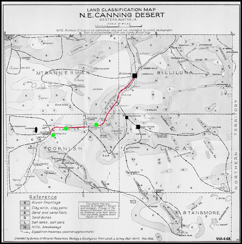
Thanks to the foresight of Natmap’s Des Young, Johnson’s original reconnaissance notes are still available. As Johnson stated in his unsigned note (mentioned above) his reconnaissance notes (refer to Annex A) indicated that the new track should join Well 51 with the then Billiluna–Balgo road to the east of Sturt Creek. From Well 51 to Well 48 the survey route was to follow an overgrown existing track (by-passing Well 50) and then follow a new track to Well 45 (the then overgrown existing track mentioned by Johnson was likely made in part by the vehicles of Terry in 1925 and later Nelligan and Casey for the Bureau of Mineral Resources (BMR) survey of 1955, please refer to the relevant maps below). This last section of track (from Well 48 to Well 45) would pass Crown Head, Eastern Hill, Mt Romilly, Crescent Ridge and Mt Ford (named after Natmap’s Reg Ford). Each of these features would be accessed for the survey. After the survey traverse had been completed in 1964, a separate National Mapping Council station summary was prepared for each of the survey points that had been constructed and occupied. Amongst other data, these summaries showed the route taken to get to each survey point. When the series of station summaries from Crown Head to Mt Ford are examined the access information can be seen to coincide with what Johnson had earlier indicated, including notes that state the route taken by the traverse party had been lightly graded.
Edited section of map after Terry (1927) showing his route to and from the Billiluna region in 1925.
Edited map after Bureau of Mineral Resources, (1956), report by Nelligan and Casey,
with Billiluna, Old Billiluna and Balgo highlighted along with the locations of Wells 50, 49 and 48 and showing the route Billiluna- Well 48.
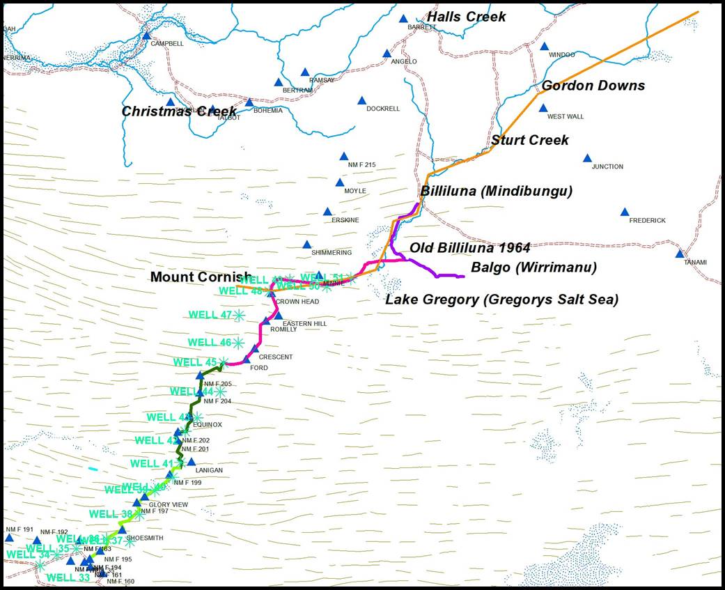
Derived map showing the Billiluna region with wells of the Canning Stock Route indicted by light blue stars and geodetic survey stations by dark blue triangles.
Terry’s 1925 route is depicted in orange, the route to Old Billiluna and Balgo as of 1964 in purple and Moyle’s 1964 track in pink.
The track scraped by Natmap in 1964 is depicted in dark green with the light green section of the track being made only by Natmap vehicle wheel tracks.
Note that a survey point to the west of Billiluna was named Mount Moyle by National Mapping, in recognition of Bill Moyle.
Retracing Bill Moyle’s Track
The R502 1:250,000 scale map series was completed in 1968 and those maps in our area of interest were field inspected in 1966; two years after Bill Moyle and Natmap’s survey party were in the area. The survey track would have still been quite evident during that field inspection and was therefore marked on the relevant map sheets. The wheel tracks from the survey were still clearly visible in mid-1968 when Dave Chudleigh, Russell Wenholz and Noel Kealley drove the whole length of the Stock Route from Wiluna to Halls Creek (Wenholz, in Gard, 2010).
Old Billiluna to Well 51 section
Track positions have changed in the Lake Gregory-Billiluna area since the early 1960s. The current so called CSR track from Well 51 north runs on the west side of Sturt Creek to Mindibungu Aboriginal Community (the location of Billiluna homestead in the early 1960s). From there the main road network goes on to Halls Creek (or toward Alice Springs) along the Tanami Road. The section from Billiluna to Tanami by-passing Balgo was initially called McGuire Track and was constructed in 1967-68 (Farrands undated). From Well 51 it is still possible to travel around Lake Gregory to the south. Moyle’s track, however, from Old Billiluna (homestead) to Well 51 is no longer on modern maps. Its disappearance is more than likely because of the increased inundation of the areas to the north of Lake Gregory making Moyle’s track increasingly impassable until ultimately no longer viable. Timms (2001) noted the three lakes that comprise Lake Gregory...were dry for most of 1930-1968...while the 1993 flooding…was one of the greatest on record….
Composite R502 of SF52-01 Cornish and SF52-02 Lucas 1:250,000 scale map sheet sections showing route of Bill Moyle’s track
from Old Billiluna homestead to Well 51 via Sturt Creek/Lungan Waterhole and C25 Waterhole/Rilya Plain
– this track is no longer marked on current maps.
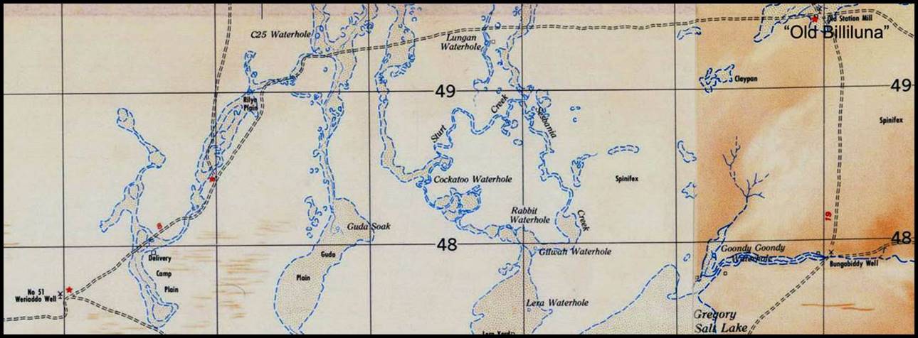
Both the pre and post-survey traverse information indicated that Old Billiluna homestead was located on the then Billiluna-Balgo Road south-east of Sturt Creek. In his reconnaissance notes, Johnson estimated the distance from Well 51 to this road to be about 30 miles (48km) across country. Old Billiluna homestead was not marked on the SF52-02 Lucas R502 or NTMS map sheets. However, some 17km south of Mindibungu, Old Billiluna ruins on the west side of Sturt Creek were marked on the SE52‑14 Billiluna R502 map sheet (but were not marked on the SE52-14 Billiluna NTMS sheet). These ruins were at a separate location to the Old Billiluna homestead on Durbai Creek that Johnson referred to in his reconnaissance notes and that was noted on some of the later survey station summaries. Old Billiluna homestead and Old Billiluna ruins both appeared on the discontinued 1:1 million scale International Map of the World sheet SE52 Halls Creek in their correct locations. McGregor (1995) contained a map with Old Billiluna homestead marked and related to several other features. The Old Billiluna homestead location thus has further provenance and the 1:1 million scale IMW sheet location can be accepted with some confidence. The IMW sheet position of Old Billiluna homestead when transferred to the Billiluna NTMS sheet coincides with the location of a windpump on Durbai Creek near Gilungarra that is labelled Old Homestead Well; some 65km from Mindibungu and 50km from Balgo.
During comparison of Johnson’s reconnaissance distances with the post-survey distances on the station summaries a 13km difference was noted in the access notes in the Old Billiluna homestead area. This difference was apparently because Johnson estimated that the intersection of the new track from Well 51 with the Billiluna-Balgo road would be closer to Sturt Creek than where it was eventually located at Old Billiluna. The R502 sheet showed a track due west from the site of old Billiluna homestead (Old Station Mill on that sheet - rather than Old Homestead Well on the NTMS sheet) to some stock yards near Lungan Waterhole on Sturt Creek. Travelling further west from Lungan Waterhole, the track continued and turned to the south-west, south of Canning’s C25 Waterhole and north of Rilya Plain. Thence the track went on to Well 51. The scaled distance of 52km between Old Homestead Well and Well 51 via this track matches the post-survey information (against Johnson’s 48km estimate). This track from Old Billiluna to Well 51 was also shown on the IMW sheet and is almost certainly the route of Moyle’s 1964 survey access track.
As mentioned above, the actual intersection of the 1964 track from Well 51 with the then Billiluna-Balgo road was 13km further south-east than Johnson estimated in his reconnaissance notes. A likely explanation of this difference is that from his reconnaissance route Johnson may have been unaware of the yards at Lungan Waterhole. It would have been necessary for some form of access to have existed between Old Billiluna and these yards after the homestead was established in the early 1920s. When it came to establishing just where to locate the survey traverse access track in 1964, it would have been likely that the then Billiluna landholder would have preferred that Bill Moyle re-grade the existing east-west route from the old homestead site to the yards near Lungan Waterhole rather than have another less useful new track cut across the property closer to Sturt Creek. Also Moyle would have had an existing route to follow for part of the way to Well 51 rather than having to undertake a delaying reconnaissance for that part of the new track route.
Well 51 to Well 48 section
On the SF52-01 Cornish R502 map sheet, a track is shown between Well 51 and Well 48 (Twin Head area) and further on to the south. This track by-passed Well 50 by running a few kilometres to the north and is annotated as Canning Stock Route. Johnson’s proposed survey traverse route closely coincided with this marked track and also by-passed Well 50 to the north. Just after Well 49, a track is shown on the R502 map sheet as leading off to the east, paralleling the northern track but going into Well 50. To the east of Well 50, this southern track is shown as soon re-joining the northern one. Gard (2010) noted that when heading north from Well 49 towards Wells 50 and 51 today, vehicles must make a sharp right turn to take the track to Well 50. The station summary for Eastern Hill also shows these parallel tracks but clearly the northern track is the main route. Hema (2003) does not show the southern alternative track to Well 50. Also the southern track was not visible on the ground in either 2007 or 2010 (McLean, 2012).
The track shown on the R502 map sheet from Well 51 to Well 48 (by-passing Well 50) closely follows the alignment of the track prepared by Bill Moyle in 1964. This section forms part of the track used by today’s CSR travellers. Canning’s well reconditioning party and subsequent cattle drives down the stock route were likely to have stayed close to that marked route from early 1930s.
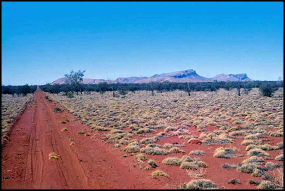
Photograph of Moyle’s track approaching Twin Head from the north-east in 1964, a few months after the track was lightly graded by Bill Moyle.
In the centre of the wheel tracks it can be seen that the spinifex has been cleared recently. The wheel tracks appear fresh on the recently graded surface.
Also visible are older wheel tracks to the left. Based on HA Johnson’s reconnaissance material,
the old track ceased near the low dark ridge that can be seen on the left before the main range (image courtesy of Kevin Snell, Natmap 1964-67).
Well 48 to Well 45 section
In this section Bill Moyle’s track passed close to Crown Head, Eastern Hill, Mt Romilly, Crescent Ridge and Mt Ford (as stated above) before his track work ended at Well 45. The R502 sheet does not show all of these features so it was necessary to refer to the current SF52-01 Cornish NTMS 1:250,000 scale sheet. The track marked on the NTMS sheet passes each of the listed features in close accordance with Johnson’s reconnaissance notes. A side by side comparison of the NTMS and R502 sheets gives complete agreement for the plotted track in this area. This track is annotated on both map series as Canning Stock Route even though it by-passes Wells 47 and 46 by many kilometres; a well to well route is not shown to the west on either the NTMS or the R502 sheet. Hema (2003) and Gard (2010) show and discuss, respectively both the well to well and alternative route, although Gard (2010) refers to the track between Well 45 and Well 46 as new. (The 1990 edition of Gard’s book indicated that then only the eastern (Moyle’s) route north from Well 45 was marked on the ground).
The map sheet and on the ground evidence is that from Well 48 to Well 45, the eastern route that by-passes Wells 47 and 46 continues to follow Moyle’s 1964 alignment and while not actually the CSR this route is used and known as such. It was not until 1982 that travellers wanting to access all Canning Stock Route wells more easily, that a route to Well 47 and Well 46 using oil search seismic lines and other connecting tracks was contrived.
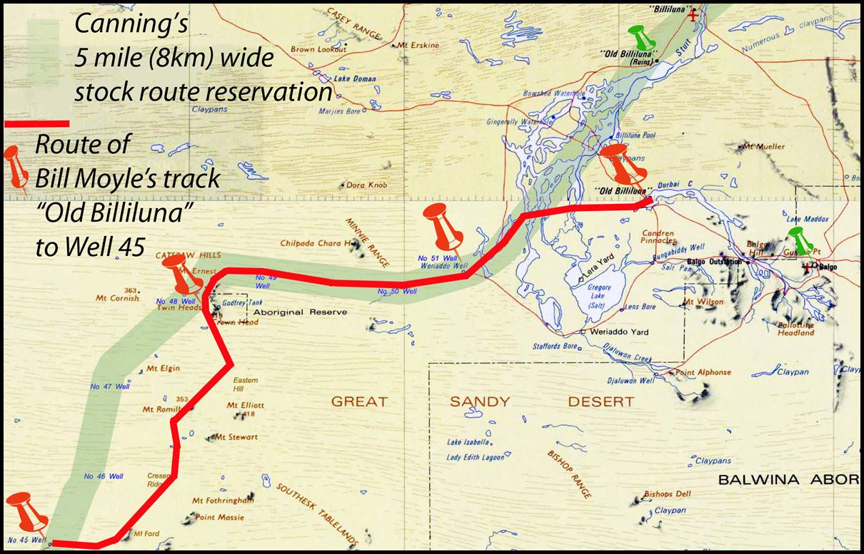
Map showing the route (red line and pins) of Bill Moyle’s track from Old Billiluna to Well 45 via Well 51 and Well 48; the stock route surveyed by Canning is indicated in green.
A Comment for the Perplexed
Surveyor Alfred Wernam Canning (1860-1936) led the parties that explored the route for the Wiluna-Kimberley Stock Route (in 1906-07) and constructed the wells and other infrastructure (in 1908-10). During 1930-31 Canning also led a party that refurbished the wells on the stock route. (The route was formally renamed the Canning Stock Route in February 1967 but had previously been referred to by that name for many years). As part of his exploration and construction survey tasks, Canning provided for the stock route to be about 400 chains or five miles (8km) wide. The wells and other waters were not always in the centre of this corridor that ran from Wiluna to Lake Gregory (near Well 51) and then mostly along Sturt Creek to Flora Valley and on to old Halls Creek township (about 15km east of the present day Halls Creek). North of the confluence of Sturt Creek and Wolfe Creek the stock route was only 100 chains (1.25 miles or 2km) wide. Canning’s route (to state the obvious) ran from well to well. It is somewhat perplexing therefore to see most of the currently available mapping label part of Natmap’s 1964 geodetic survey traverse access track and other present day track deviations as the Canning Stock Route even when these latter tracks can be up to 20 km away from the wells. A notable exception is Westprint Heritage Maps’ Canning Stock Route sheet that takes a better approach and shades the original 8 km wide stock route so it is clear to users of this map when the present day access track deviates from Canning’s original route.
Photograph of Moyle’s track in 1964 looking north-east to Mount Ford just a few months after the track was lightly graded.
(Image courtesy of Kevin Snell, Natmap 1964-67).
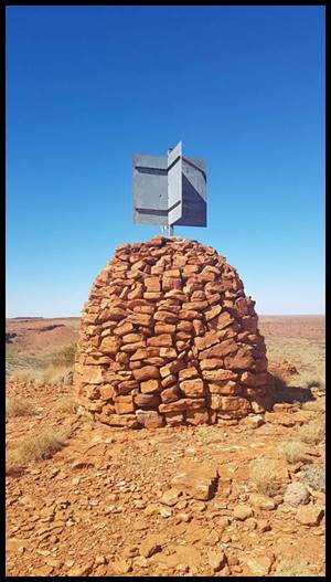
The survey beacon and cairn on Mount Ford at July 2019,
named in honour of National Mapping's Reginald Arthur (Reg) Ford who on 1 January 1968 was awarded the Medal of the Order of the British Empire (Civil) ((BEM-(C))
for meritorious service for his national mapping effort; particularly to the national geodetic survey.
Also indexed as NM/F/206, Reg and his party erected the cairn in 1964 after using Moyle’s track to access the area (courtesy Connor Maggots).
|
|
|
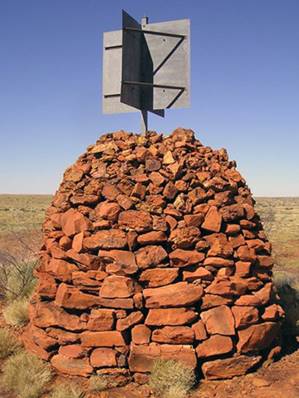
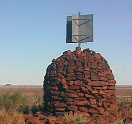
Survey beacons and cairns on (left) Crescent Ridge (NM/F/207) and (right) Mount Romilly (NM/F/208), also erected by Reg Ford’s party in 1964.
Bill Moyle’s track today
Aboriginal groups hold native title over virtually all of the Canning Stock Route. Their title is the highest form of native title – a right to exclusive possession and enjoyment. They have a legal right to give or withhold permission for people to travel over this native title country unless people have some other right of access. These native title rights are subject to a public right of access over the Canning Stock Route. This is the original historic stock route, including a corridor either side of the Canning Stock Route. This means that there is a mix of different rights, Indigenous and non-Indigenous along the Canning Stock Route. Permits are thus now required in order to traverse the CSR (Kuju Wangka, 2014). These permits only allow some departure from the main vehicular route meaning that today any travel along that section of Moyle’s track between Wells 45 and 48 is routinely prohibited.
As described above the section of Moyle’s track in the Lake Gregory-Billiluna area has been flood impacted since the early 1960s, leaving the only section of Moyle’s track travelled today as that between Wells 48 and 51. Unfortunately this section of Moyle’s work was just absorbed into the totality of the CSR and few if any recognise the special history of this part of the CSR. Even before Moyle, Michael Terry and his 1925 expedition had travelled down Sturt Creek to the Salt Sea (Lake Gregory). From Well 51 Terry’s route took him past Well 50 to Well 48 and his journey’s end around Mount Cornish.
Prepared April-June 2012, updated May 2016 and August 2023
References
Bohemia, Jack & McGregor, Bill (1995), Nyibayarri: Kimberley Tracker, Aboriginal Studies Press, Canberra.
Bureau of Mineral Resources, (1956), Land Classification and New Geographical Names in the North-East part of the Canning Basin, Western Australia, report by Patrick Francis Nelligan, a surveyor from the Department of Lands and Survey, Perth and John Newbery Casey, from the Bureau, RECORDS 1956/106, accessed at : https://ecat.ga.gov.au/geonetwork/srv/eng/search#!a05f7892-9bbf-7506-e044-00144fdd4fa6
Canning, AW (1910), Plan of Wiluna-Kimberley Stock Route Exploration also shewing positions of wells constructed 1908-9-10. Memento map for the 150th anniversary celebrations of Western Australia, Department of Mines, Perth, 1978.
Chudleigh, DC (1969), Retracing the Canning Stock Route and Other Early Explorers' Routes in Central Western Australia, The Australian Surveyor, December 1969, pp. 555-563.
Deckert, John and Ussing, Jo (2006), Canning Stock Route (map), Westprint Heritage Maps, Nhill, fourth edition.
Farrands, Bruce (undated), Rabbit Flat Roadhouse. Australia’s Most Remote Roadhouse, The Story section of website, accessed 24 May 2012 at https://rabbitflat.com.au/story .
Ford, RA (1979), The Division of National Mapping’s part in the Geodetic Survey of Australia, The Australian Surveyor, vol. 29, no. 6, pp. 375-427; vol. 29, no. 7, pp. 465-536; vol. 29, no. 8, pp. 581-638.
Gard, Ronele and Eric (1990), Canning Stock Route: A Traveller’s Guide, Western Desert Guides, Wembley Downs, reprinted 1991, ISBN:0-7316 4433-6.
Gard, Ronele and Eric (2010), Canning Stock Route: A Traveller’s Guide, Western Desert Guides, Wembley Downs, reprinted 3rd Edition, ISBN:0-9586715-1-6.
Geoscience Australia (2008), NATMAP Digital Maps 2008 on DVD, NTMS 1:250,000 scale series and the International Map of the World (IMW) 1:1,000,000 scale series of Australia.
Geoscience Australia (2010), A set of maps from the 1:250,000 scale, R502 series on electronic media (540 maps).
Hema (2003), Great Desert Tracks Map Series on CD, Hema Maps Pty Ltd, Eight Mile Plains.
Johnson, HA (undated), Notes, access sketches and route plots prepared following reconnaissance for the Halls Creek to Well 35 geodetic survey traverse during September-October 1962; unpublished reference material, Division of National Mapping, Melbourne.
Johnson, HA (1963), Division of National Mapping, Great Sandy Desert and Canning Basin WA, Going and General Information Supplied to WAPET, 22 April 1963. Unpublished report prepared for Western Australian Petroleum Pty Ltd, Division of National Mapping, Melbourne.
Johnson, HA (1964), Geodetic Surveys through the Australian Sandridges, The Australian Surveyor, September 1964, pp. 157-184.
Kennedy, Brian, and Barbara (1989), Australian Place Names, Hodder and Stoughton, 1992 edition, Sydney.
Kuju Wangka, (2014), Canning Stock Route, Vol.4, accessed at : https://www.thecanningstockroute.com/assets/docs/csr_9.33683858.pdf
McLean, Laurie (2012), Personal recollections from vehicle travel on Canning Stock Route tracks in 2007 and 2010.
Readers Digest Services Pty Limited (1977), Readers Digest Atlas of Australia, Readers Digest Services Pty Limited, Sydney, (in which the maps were sourced from the Division of National Mapping's 1:1million scale International Map of the World series).
Slee, John (1979), Canning, Alfred Wernam (1860–1936), Australian Dictionary of Biography, National Centre of Biography, Australian National University, http://adb.anu.edu.au/biography/canning-alfred-wernam-5499/text9355 accessed 14 May 2012.
Snell, Kevin (2012), conversation with Paul Wise at Echuca, Victoria on 14th May 2012. (Mr Snell worked with National Mapping’s geodetic and topographic field survey parties between 1964 and 1967. He was a member of Reg Ford’s 1964 Canning Stock Route survey party and recalled meeting Bill Moyle at Carranya. Kevin's father was a cousin of William Albert Snell one time mayor of Leonora who led the initial restoration of Canning Stock Route wells in the late 1920s.)
Sprigg, Griselda and Maclean, Rod (2001), Dune is a four letter word, Wakefield Press, Kent Town, reprinted 2012.
Terry, Michael (1926), Through Northern Australia: Report of the Terry Australian Expedition, The Geographical Journal of the Royal Geographical Society, London, Vol.68, No.4, pp.302-325.
Terry, Michael (1927), Through a Land of Promise : with gun, car and camera in the heart of Northern Australia, Herbert Jenkins Ltd., London.
Timms, BV (2001), Large Freshwater Lakes in Arid Australia: A review of their limnology and threats to their future, Lakes & Reservoirs: Research and Management, 2001, no. 6, pp. 183–196.
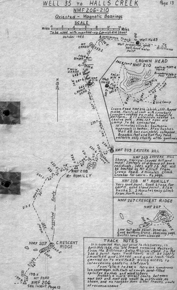
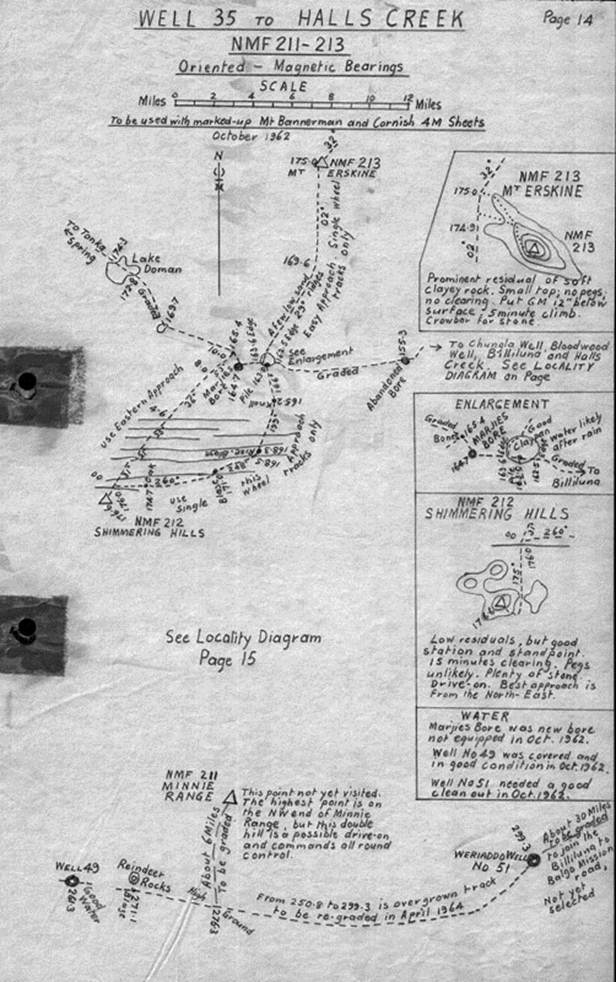
Extracts from H.A. Johnson’s original reconnaissance material describing the track requirements
(Source: Johnson, undated, pp.13 & 14)
|
|
|