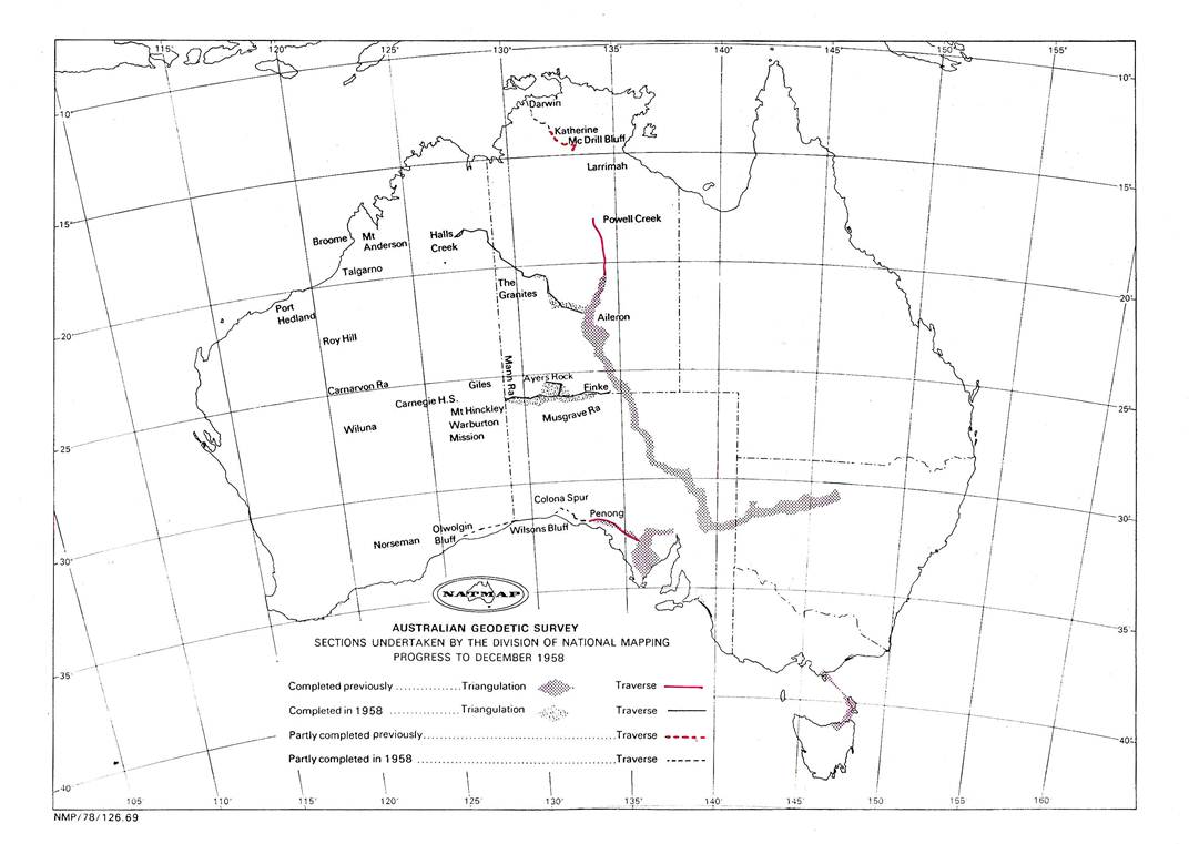
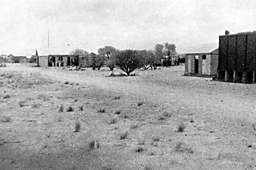
Field Operations 1958
The Weapons Research Establishment (WRE) was interested in having First Order control in the Talgarno area (between Port Hedland and Broome WA) by the end of 1959. This was in connection with their “Blue Streak” rocket program. To help achieve this objective they promised support in the way of Field Assistants and vehicles. This was taken into account when arranging the 1958 field program which was:
(i) Reconnaissance, Musgrave Ranges, SA - Giles, WA.
(ii) Reconnaissance, Giles - Carnegie H.S. WA - including selection of the route for a track to be graded by L. Beadell of WRE (later nicknamed “The Gunbarrel Highway”).
(iii) Reconnaissance, Carnegie HS - Roy Hill, WA and Mt Anderson - Halls Creek.
H.A. Johnson would complete these tasks.
(i) Reconnaissance, Colona Spur - Norseman, WA, selecting tower sites where necessary with the reconnaissance vehicles.
(ii) Reconnaissance, Powell Creek - Larrimah.
A.H. Spowers would complete these tasks.
(i) Beaconing and observing Finke NT - NT, WA, SA Border area.
(ii) Beaconing and observing Aileron NT - Halls Creek, WA.
R.A. Ford would complete these tasks.
(i) Beaconing and observing, Penong - Colona Spur, SA.
(ii) Beaconing and observing Colona Spur - Madura, WA.
(iii) Beaconing and observing, Darwin - Katherine, NT.
A.H. Spowers would complete these tasks.
The field party under R.A. Ford left Melbourne in late March calling at WRE Salisbury SA en route where a Morris 4 x 4 truck with driver (R. Campbell) and also a Commer 4 x 4 truck with driver, joined the party; two short wheel base Land Rovers with trailers which were to be driven by our own personnel were also collected. All were equipped with Traeger radios which had crystals for the WRE frequencies. Similar crystals had been purchased for our own radios so we now had good inter-party communication as well as a good channel for telegrams to Melbourne.
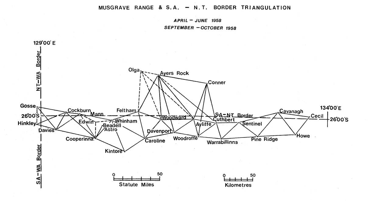
Leaving Salisbury the party travelled by road to Kulgera and beaconed twenty-one hills between Finke and the Mann Ranges. These included some very high peaks in the Musgrave Ranges, Mt Woodruffe (the highest mountain in SA), Mt Warrabillinna, Mt Woodward, Mt Davenport and Mt Kintore, all of which were solid climbs.
The Musgrave Ranges in their own way are just as spectacular as the Flinders and MacDonnell Ranges; however they differ in that they rise directly from the plain, thus one can drive to the foot of the mountain from where it is steep climbing all the way.
The old pole in the large cairn on Mt Woodruffe was still in good order with the engraved name still clearly readable; it was brought down and taken to the Surveyor General SA on the way home; it was later exhibited in the Adelaide Museum.
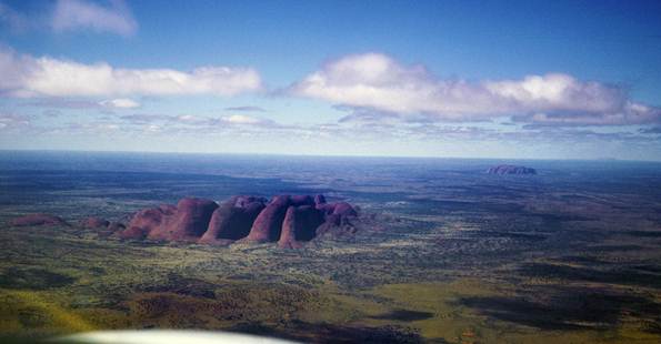
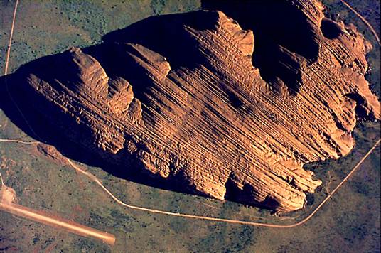
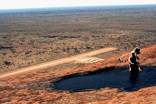
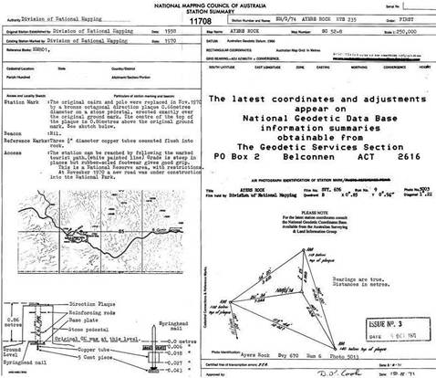
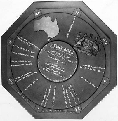
During this period the party had the pleasure of establishing the station mark on Ayers Rock and building our normal cairn with pole and vanes. This was replaced with the current Direction Plaque in 1970.
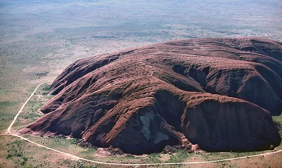
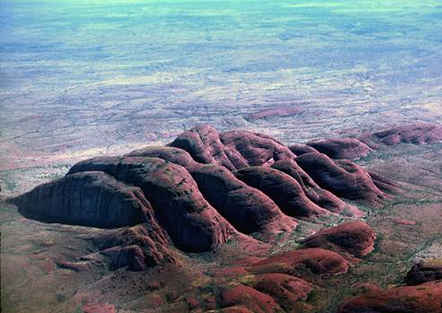
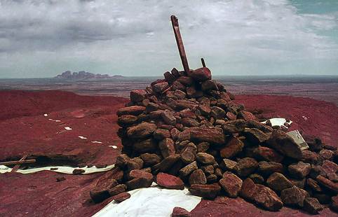
Also of interest was the establishing of a station mark and cairn on Mt Olga. This spectacular rock can be very dangerous to climb and not a great number of people have attempted it. H.A. Johnson had provided a sketch of the route he had used. The party was only to put in a station mark, clear the odd bushes and improve the existing cairn so that it could be intersected from our primary stations. R. Ford and J. Graham arrived ahead of the main party and climbed to the summit to investigate the route and to ascertain the requirements for the cairn.
Next morning most of the party were able to complete the climb, the old cairn was dismantled (it was not a survey cairn, having been built by those who had climbed Mt Olga), and a station mark was set in the centre. There was a bottle at the site containing the names of some thirty previous climbers, No 1 was the NT Police Trooper McKinnon (in the late 1930's), No 2 J. Bechervaise (in the late 1940's), while Nos 3 and 4 were D.R. Hocking and F.J. McCoy of National Mapping (in 1951).
On the completion of the beaconing, the party was organised for observing westward from Mt Grundy, near Finke. Three observers were available, A. Colvin, G. Cruickshanks and R. Ford. Twenty one hills, mainly of triangulation were observed in this phase which was completed in June just as the weather was turning cold and wet. It had been necessary to camp on the summits of some of the peaks as the descent took too long to be safe after dark.
It had been decided before the start of the season that the best time to complete the Aileron - Halls Creek traverse was in the coolest part of the year; the party now proceeded to Alice Springs to put that into effect. Beacons were erected from Mt Gardner to The Granites. The hills in this area were close to the old disused track to The Granites which is some distance from the present graded road through the flat country. The old track was found to be non-existent, the route being defined by a growth of shrubs, mainly Minnaritchie, in the old wheel tracks. Before proceeding further north the observing of this section was completed, some fifteen stations in all. During this period training in observing was commenced for Field Assistants, E. Lewis and J. Graham.
The section, Granites - Halls Creek (Mt Barrett) was now beaconed, very rough country being traversed en route. Observing was done in the reverse direction, some seventeen stations being completed. The only trouble experienced was a shortage of water, the bore at Tanami being in disrepair. As air photo coverage was available of this area, photo identification was completed at each station.
It was now late September and the party returned to the Musgrave Range area to continue westward. The decision to do the northern work between June and September had been the right one. Heavy rain had fallen in the Musgrave Range area during the period, considerably delaying the Tellurometer party who had been unlucky enough to be in the area at that time. However, by now the country was showing the benefit of the downpour, wild flowers abounding.
Beaconing and observing was completed to the line Mt Gosse - Mt Hinkley close to the three State border corner, NT-SA-WA, six stations being involved. All hills in this section were solid climbs.
A solid triangulation chain now extended along the NT-SA border from the vicinity of Kulgera on the Stuart Highway to the WA border; and included Mt Conner and Ayers Rock well to the north. Further rain and heavy thunderstorms were experienced while this work was in progress, probably luckily for the observing party as water was not easy to obtain unless long journeys were undertaken. Figure 3 shows the triangulation diagram.
H.A. Johnson had just completed a reconnaissance west from Mt Hinkley to Mt Talbot near Warburton Mission. It was good triangulation country and he remarked “This will probably be the last triangulation scheme you will observe”. It was decided to beacon this section of the work before the party returned to Melbourne, some eleven stations being involved. The task proved strenuous as the weather was hot and travelling was slow, however the mission was successfully completed and the party returned to Melbourne during November.
The field party under A.H. Spowers left Melbourne in March and completed the reconnaissance from Colona Spur to Norseman, WA fairly quickly now that the two reconnaissance vehicles were available. After completing the difficult area near the Head of the Bight, advantage was taken of the intervisibility across the sea of small “capes” along the cliffy coastline of the Bight. This system was used to cover 200 miles to Wilsons Bluff, close to the SA-WA border. From Wilsons Bluff to Olwolgin Bluff, another 160 miles west, the same system was used along the edge of the inland escarpment. From Olwolgin Bluff to Norseman, tower sites were selected using the reconnaissance vehicle. When this was completed a further reconnaissance was made to select stations on the short traverse needed to connect the station on Colona Spur with the Army Survey Corps station at Ooldea. Figures 1 and 2 show the reconnaissance vehicle with the tower in mobile and reconnaissance positions.
Beaconing and observing now commenced; cairns with pole and vanes being erected on the rocky points while a pole and vanes strutted with “Unimet” was used on the sandy points. Two observing parties were now formed, R. James and H. Couchman being the observers. They completed the observing from Penong to Colona Spur.
At the conclusion of the observing the field party moved to the Darwin area. Here the same observers completed the section of the traverse NM/G/21 (near Darwin) to McDrill Bluff. The Tellurometer measuring of this section was to be done by the NT Lands and Survey Branch.
The reconnaissance to select tower sites between Larrimah and Powell Creek was also completed with the reconnaissance vehicles. As the trees were higher than the 30 ft towers which were to be used, it was necessary to utilise firstly the cleared line of the railway because of its longer straights and then the cleared line of the Stuart Highway. Towers were sighted at the bends and as they are numerous many short lines were necessary, some under a mile. The whole traverse covered 216 miles, and required 48 tower stations.
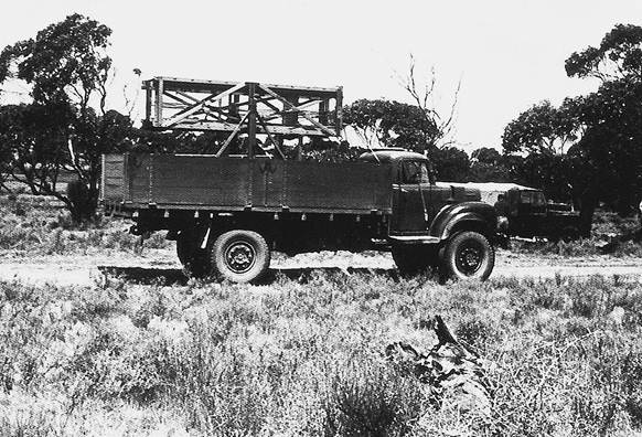
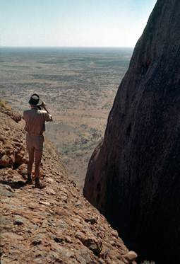
Figure 1: Reconnaissance tower on Commer truck, mobile position.
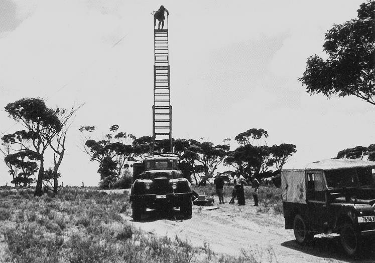
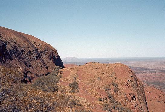
Figure 2: Tower erect for reconnaissance; height at eye-level 30 feet