Control Survey for 1:100 000 Scale Mapping,
Archipelago of the Recherche, Western Australia
March 1984
by Brian Murphy, Survey Party Leader, October 2020
(the day-to-day Coordination and Reconnaissance and Field Survey related activities being a condensed version of my digitised, daily diary entries with company and individual’s names, not directly connected with National Mapping or its contractors, removed for copyright or privacy reasons); additional material by Paul Wise.
Introduction
In March 1984, the Survey Operations Branch, National Mapping Canberra, undertook a major mapping control survey in the Archipelago of the Recherche, off Esperance, Western Australia. This survey covered the following three 1: 100 000 scale map sheet areas :
3229 Causeway
3329 Mondrain
3429 Recherche.
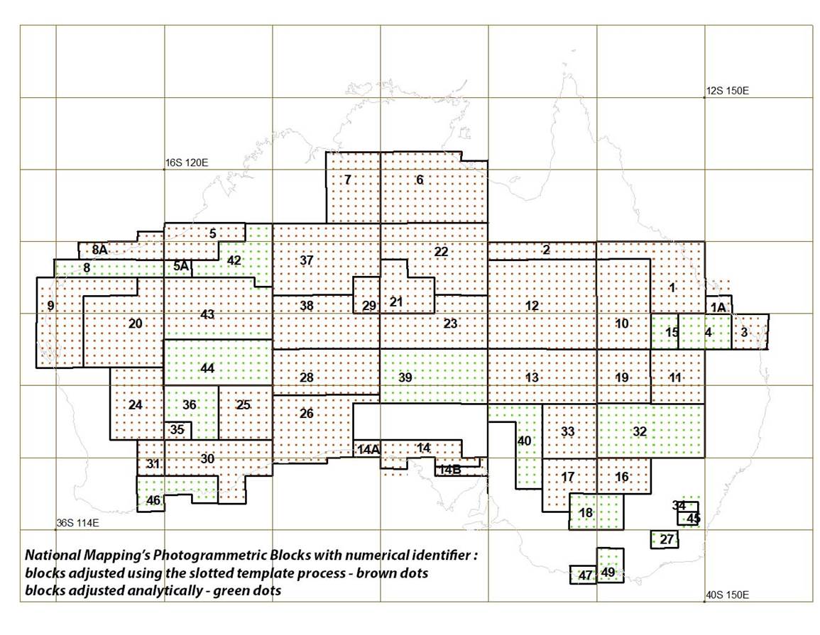
The survey was to provide photogrammetric mapping control throughout these offshore map areas of Photogrammetric Block 46, please refer Attachment A.
All islands of the Archipelago of the Recherche are included in the Recherche Archipelago Nature Reserve. Much of the contiguous land area is included in the Cape Le Grand National Park, with a small portion forming part of the Cape Arid National Park. It was therefore essential that the mapping control survey be fully coordinated with the relevant Western Australian government authorities. Accordingly, in early December 1983, face-to-face briefings and discussions were held in Perth with senior management of the West Australian National Parks Authority, Wildlife Research Authority and the Geodetic Survey Division, Department of Lands. Follow-up discussions were later held on the ground in Esperance with National Parks Authority Rangers. Due to search and rescue (SAR) considerations, the Esperance police and local hospital were briefed, initially in December 1983, and again before commencement of the survey in March 1984. Using a locally chartered aircraft, a detailed reconnaissance of the survey area was carried out in early December 1983.
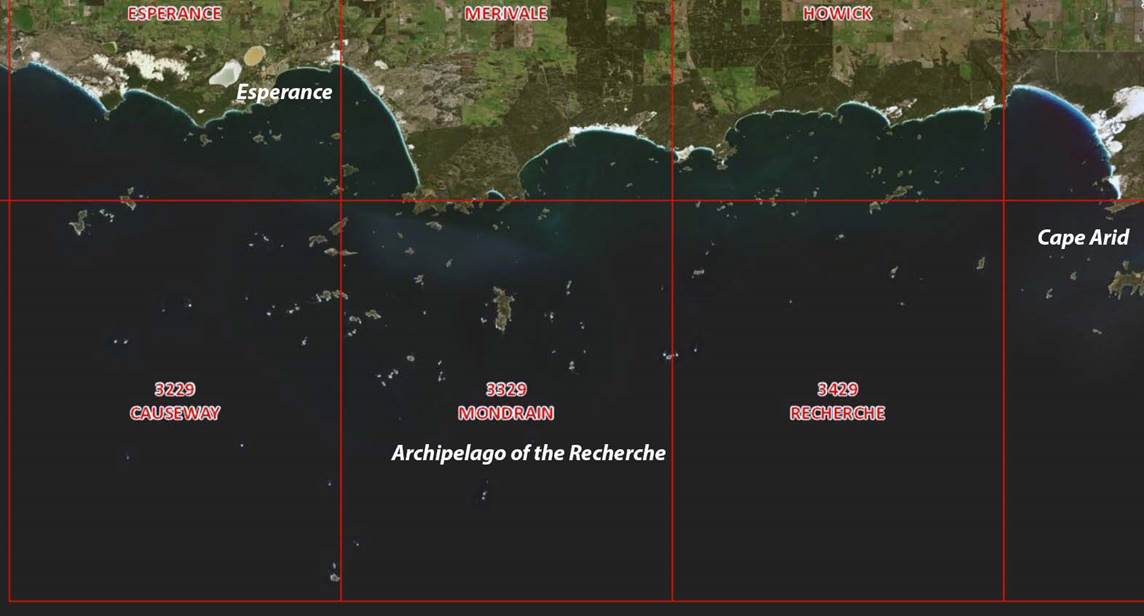
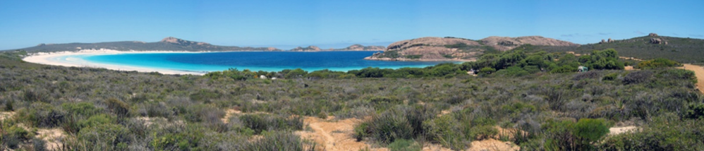
Region of survey, 1: 100 000 scale map sheet areas, Archipelago of the Recherche, Western Australia.
Survey methodology
The primary method of positioning the mapping survey control employed the now obsolete multi-station Doppler satellite translocation technique. This technique depended upon Doppler observations to the now defunct United States Transit Navy Navigation Satellite System (NNSS), which consisted of a constellation of 4-5 satellites, in polar orbit some 1075 kilometres above the surface of the earth. A total of four Magnavox MX1502 Doppler satellite receivers were used. Two receivers were always located at control stations whose coordinates were known in terms of the now obsolete Australian Geodetic Datum 1966 (AGD66) (two feet on the ground so to speak, for redundancy); the other two receivers were moved to the various locations where position was required. At each of the locations where position was required, Doppler data from the two masters and the remote(s) were thus acquired simultaneously. The Doppler data for each receiver was recorded on magnetic cassette tape which was post processed through a multi-station network adjustment program, Magnet, by the Survey Information and Geodetic Analysis Branch in Canberra. The use of redundant master control stations was also important in terms of the derivation of transformation parameters from the satellite datum to the local AGD66 datum. In fact, the stations always used as master control stations during this survey formed part of a Royal Australian Survey Corps (RASC) second order coastal control traverse. Use of the MX1502's was supplemented by electronic distance measuring equipment (EDM), being an AGA Model 8 laser Geodimeter, Wild T2/T3 theodolites and a Motorola Mini-Ranger, C-band, short to medium range, line-of-sight, distance measuring system, complete with transponders.
Planning of the Doppler satellite observations was greatly facilitated by the ready availability of broadcast ephemerides for the satellite constellation through the MX1502 receivers. The ephemerides allowed planning of the survey in order to optimise the number of acceptable common satellite passes (usually >17) tracked simultaneously at all four stations, two master and two remote. Several of the remote stations occupied by the MX1502's were existing control stations established by the Royal Australian Navy (RAN) Hydrographic Service or the Geodetic Survey Division, Western Australia Department of Lands. Due to vagaries of the weather in the area, survey planning was never done more than 12-24 hours in advance, always based on the satellite ephemerides. Daily MX1502 positioning operations were usually planned the night before.
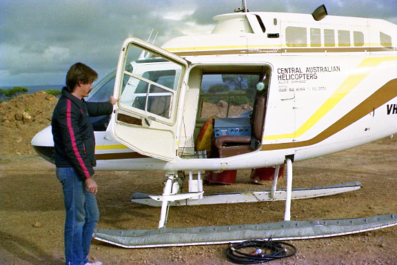
In order to facilitate access to the subject islands, it was decided to call tenders for a helicopter contract. This tender process resulted in the awarding of the contract to the Alice Springs based Central Australian Helicopters Pty Ltd, which agreed to supply a Bell 206 Jet Ranger. The helicopter pilot was Graeme Hill-Smith. The positioning of a number of offshore reefs and shoals was greatly facilitated by the use of the Mini-Ranger pulsed radar positioning system. The master control console mounted in the helicopter interrogated at least two transponders which were located on known island or shore stations. The Mini-Ranger positioning extended as far offshore as Recherche Rock, some 43 kilometres off the mainland coastline, which is symbolised on 3429 Recherche 1: 100 000 map sheet. The helicopter was able to accommodate the vertical mounting of a Hasselblad camera for spot photography of control stations. As the helicopter was operating over the open sea, safety was always a primary consideration. In case of an emergency, a four-place, bottle-inflatable life raft was always carried aboard the helicopter during this survey.
Previous Nat Map experience had shown that boat access to the eastern islands in the Archipelago of the Recherche was always hazardous due to prevailing sea conditions, which could change for the worse at very short notice. The islands generally consisted of granite domes, covered with very low vegetation, with very smooth sea-land interface areas, especially on the landward side. The risk imposed by this combination of the elements and geology was demonstrated in 1983 when the Western Australia Lands Department had an MX1502 receiver swept off one of the Mondrain map sheet (MDN) series of control stations by wave action. The receiver was subsequently recovered, separated from its 12 volt power supply and antenna, in a large rock fissure and above sea level, on the leeward side of the island. The Magnavox was only recovered with the aid of its audible warning facility which was indicating that it was low on power! During the subject survey, an attempt to locate an MX1502 receiver on Hendy Island, approximately due south of Esperance, had to be very quickly aborted. On a landing approach, the leading edge of a breaking wave suddenly reached the skids of the helicopter (when quickly lifting off and pulling away from this proposed site, one of the survey team remarked that… “he would not even leave his mother-in-law there!” The summit of this island was subsequently determined to be 14 metres above mean sea level). These experiences dictated that all unattended technical equipment be suitably tied down during the survey, to prevent damage from the elements as much as possible.
Survey personnel
The following Survey Operations Branch personnel took part in this survey. Designations refer to those at the time of survey.
Brian Murphy, Surveyor Class 2 (Party Leader)
Paul Wise, Surveyor Class 2 (seconded from the Dandenong office for the duration)
Frank Blanchfield, Surveyor Class 1
Steve Yates, Technical Officer Grade 2
Tom Mueller, Technical Officer Grade 2
Geoff Starkey, Technical Officer Grade 2 (Electronics)
Noel Templeman, Field Assistant
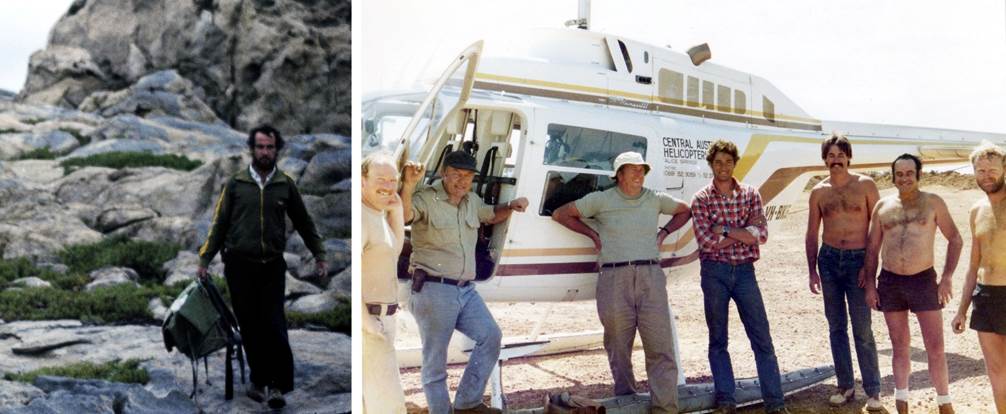
1984 Survey Party members : Frank Blanchfield descending the heights of Termination Island (left) and (right) Paul Wise, Graeme Hill-Smith, Brian Murphy, Steve Yates, Geoff Starkey, Noel Templeman, Tom Mueller, at Lucky Bay camp site on the morning of Friday 23 March, after completion of packing up this camp (thanks to Steve Yates for finding this photo taken by Frank Blanchfield).
Coordination and Reconnaissance
Murphy flew Canberra-Perth; overnighted Perth.
Monday 5 December 1983
Murphy visited :
|
Western Australia National Parks Authority to brief Director and Secretary on forthcoming mapping control survey in the Archipelago of the Recherche; |
|
|
- |
Geodetic Survey Division, Western Australia Lands Department to brief on forthcoming survey; offered WA Lands’ Aero Commander, at cost, for spot photography, and provided with a sample of the material recently used for panelling control stations on small granite islands in the Archipelago of the Recherche; |
|
- |
Western Australia Wildlife Research Authority to brief on forthcoming survey. |
Paul McCormack, Senior Technical Officer Grade 1, arrived from Canberra at 2040hrs, prior to boarding MV Cape Pillar arriving Esperance on Wednesday. McCormack to be relief watch-keeper on Bathymetric operations being conducted by Nat Map.
Murphy :
|
- |
Departed Perth 0600hrs, arrived Esperance 0740hrs; collected hired 4WD tray-top; then to accommodation; |
|
- |
Departed Esperance 1000hrs for Cape Le Grand for meeting with National Park Rangers; carried out inspection of proposed camp site in gravel scrape near Lucky Bay (3330 Merivale 1:100 000 map sheet, GR 235402 refers); |
|
- |
Drove to Wharton, Duke of Orleans Bay caravan park to inspect proposed rental house accommodation (3430 Howick 1:100 000 map sheet, GR 608459 refers), arrived 1600hrs; registered tentative booking for March 1984; returned to Esperance accommodation 1930hrs. |
Wednesday 7 December 1983
Murphy :
|
- |
Proceeded aboard MV Cape Pillar, with Paul McCormack, after vessel docked for crew change at Esperance 1100hrs; |
|
- |
Completed aerial recce aboard low-winged, twin-engine aircraft, chartered from Esair P/L, of proposed control station sites in the Archipelago of the Recherche; Paul McCormack aboard to carry out Hasselblad oblique spot photography; take off 1220hrs - returned 1450hrs; |
|
- |
Visited police and hospital and briefed them on project; returned to accommodation. |
Thursday 8 December 1983
Murphy departed Esperance by air for Perth/Melbourne/Canberra.
Field Survey (Only party member’s surnames given)
Thursday 1 March 1984
Mueller/Yates/Starkey/Templeman departed Canberra for Esperance by vehicle; 2 D1300 Internationals plus ACCO truck with technical and camping equipment. As all the new mapping control points were to be established on granite, the equipment included a helicopter portable 240 volt generator. At a new station, the generator powered a hand held drill, with a suitable drill bit for granite, to make the necessary holes to take lead plugs with brass tags, on which was stamped the station number. Other plugs had appropriate eyelets to enable unattended equipment to be firmly tethered.
Blanchfield/Murphy/Wise flew Canberra/Melbourne to Perth; arrived 2045hrs; overnighted Riverdale, Perth.
Monday 5 March 1984
Blanchfield/Murphy/Wise departed Perth by air; arrived Esperance 0740hrs.
Collected hire car; met Mueller/Yates on way into Esperance.
Accommodation Esperance.
Murphy briefed Wise from 0845hrs to 1300hrs. Then drove to Wireless Hill trig for recce. Visited local police station and provided update on forthcoming operations and general area. Visited Esair P/L, and gained permission to use their airstrip. Visited local hospital and briefed matron on forthcoming operations. Drove towards Cape Le Grand and met Chief Ranger, Cape Le Grand National Park. Briefed him on forthcoming operations and proposed establishment and occupation of temporary camp site in a large, flat area of gravel scrape at Lucky Bay within the boundary of national park (previously arranged on 6 December 1983 recce and by telecon). Recced stations Esperance51 and Ross (RAN).
Blanchfield/Mueller/Yates/Templeman/Starkey picked up 10 drums of Aviation Turbine Kerosene (ATK) from Esperance airstrip for delivery to Duke of Orleans Bay. Recced station Esperance6 Saddleback and then attempted to access R272 Alexander without success (2 x D1300 Internationals plus ACCO).
Returned Esperance.
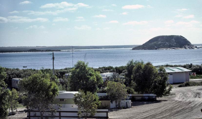
View from verandah of rented accommodation, Duke of Orleans Bay (courtesy Paul Wise).
Tuesday 6 March 1984
Departed Esperance at 1015hrs by road.
Party arrived Duke of Orleans Bay at 1130hrs.
Unloaded vehicles; set up large rented house to accommodate survey party; house located within 50 metres of helipad.
Wednesday 7 March 1984
0800hrs whole party at Duke of Orleans Bay.
Mueller/Yates attempted to drive to R272 Alexander, but had major problems in accessing station; deep sand forced winching etc. All electrical wiring under International badly damaged.
Helo departed Forrest, on transcontinental railway line, at 0852hrs (ex Alice Springs). Called from Cocklebiddy at 1015hrs; contact made on Codan SSB VHF radio, using 6 MHz; loud and clear although some 400 kilometres distant. Contracted Central Australian Helicopters P/L, Bell Jet Ranger 206 VH-BKG, piloted by Graeme Hill-Smith, arrived at Duke of Orleans Bay at 1235hrs.
Thursday 8 March 1984
0805hrs at Duke of Orleans Bay.
Blanchfield/Yates helo to R271 Belches; set up MX1502; helo returned to Duke of Orleans Bay.
Wise/Mueller helo to R272 Alexander.
R271 Belches party observed horizontal direction to auxiliary RO from R272 Alexander; set up Mini-Ranger transponder; marked station for spot photography.
R272 Alexander party set light on line to R271 Belches; set up MX1502; set up Mini-Ranger transponder; marked station for spot photography; checked line to NMF 690 Helby Island.
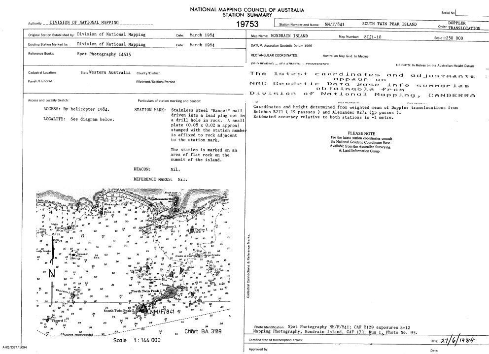
Blanchfield/Mueller helo to NMF 841 South Twin Peak Island; established station, set up MX1502; marked for spot photography. Airborne and spot photograph station from 4 000 feet, returned to Duke of Orleans Bay.
TOTAL FLYING TIME THIS DAY: 2 hrs 30 mins.
Friday 9 March 1984
0700hrs at Duke of Orleans Bay.
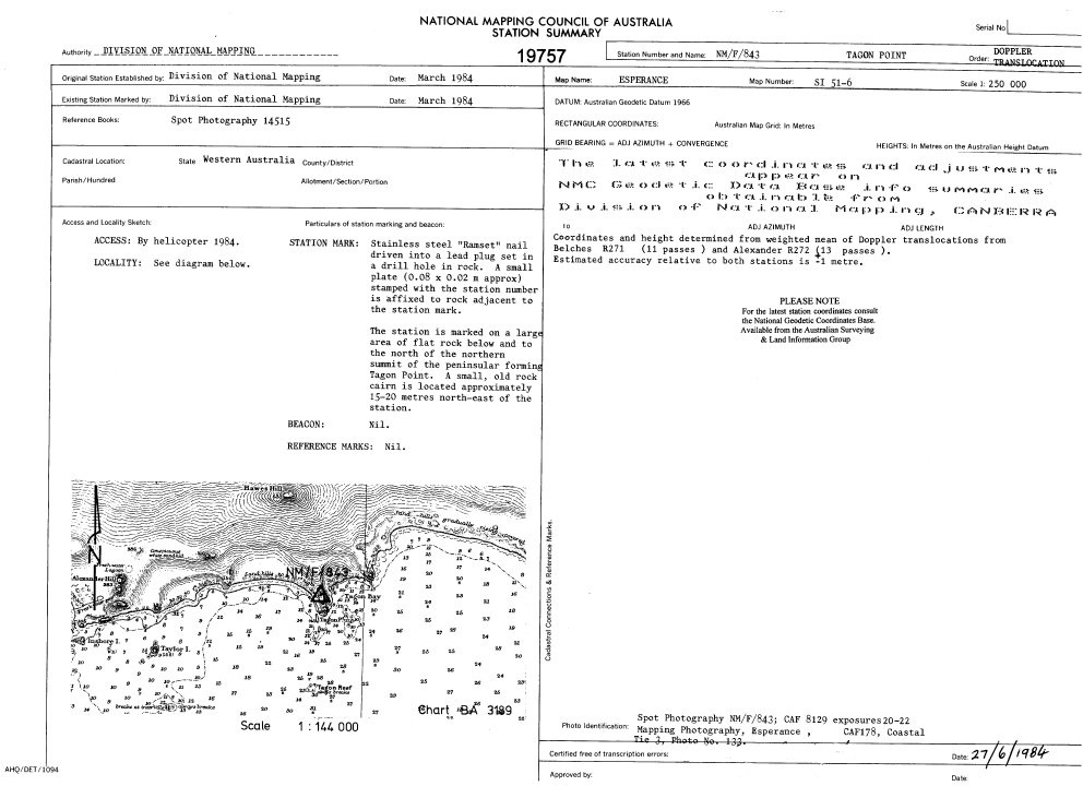
Blanchfield/Murphy helo to NMF 843 Tagon Point; established station; set up MX1502 and marked for spot photography. Airborne, climbed to 4 000 feet and spot photographed station. Then to R272 Alexander to spot photograph from 4 000 feet. Returned to Duke of Orleans Bay.
Blanchfield/Starkey helo to R271 Belches; set up for horizontals/SRV’s (Simultaneous Reciprocal Vertical angles) to NMF 845 Marts Island and NMF 844 Tizard Island and Geodimeter measurement from NMF 845 Marts Island.
Mueller/Murphy helo to NMF 845 Marts Island; set up for horizontals/SRV’s/Geodimeter measurements to R271 Belches and NMF 844 Tizard Island.
Wise/Yates helo to NMF 844 Tizard Island; set up for horizontals/SRV’s to NMF 845 Marts Island and R271 Belches and Geodimeter measurement from NMF 845 Marts Island. Then helo to R272 Alexander; set up for SRV’s to R271 Belches, horizontals and SRV’s to NMVF 500 (unofficially known to party as Legzde Island).
Helo returned to Duke of Orleans Bay to refuel, then to NMF 845 Marts Island where picked up and transferred Mueller/Murphy to NMVF 500 Legzde Island where party set up for SRV’s and Geodimeter measurements to R271 Belches and R272 Alexander.
Brian Murphy at NMV/F/500 “Legzde Island” at around 1600hrs on the afternoon of Friday 16 March 1984, with a very strong wind and rain squall approaching from the south-west which prevented take-off for some 90 minutes; Mondrain Island is in the middle distance (photograph taken by Tom Mueller).
A very severe squall halted SRV observations from NMVF 500 Legzde Island to R272 Alexander before completion; unable to observe SRV’s to R271 Belches as party abandoned that station also due to severe squall. Helo at NMVF 500 Legzde Island for some 90 minutes unable to start up and become airborne due to weather conditions, especially the very high winds. Then to R272 Alexander; retrieved Wise/Yates. Then returned to Duke of Orleans Bay via R271 Belches picking up T2 theodolite.
TOTAL FLYING TIME THIS DAY: 3 hrs 34 mins.
Saturday 10 March 1984
0710hrs at Duke of Orleans Bay.
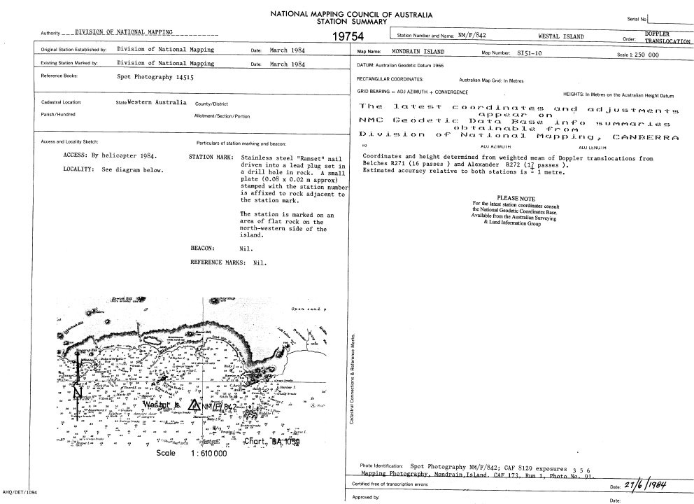
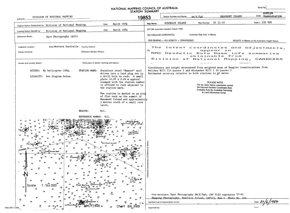
Blanchfield/Yates helo to NMF 842 Westall Island, recovered MX1502; then to NMF 846 Beaumont Island, established station, set up MX1502, marked for spot photography; returned to Duke of Orleans Bay.
Mueller/Wise helo to NMF 841 South Twin Peak Island, recovered MX1502; then to NMF 844 Tizard Island, NMF 845 Marts Island and NMF 846 Beaumont Island and spot photographed latter 3 stations. Then to NMF 848 Finger Island, established station, set up MX1502 and marked for spot photography. Airborne and spot photographed station from 4 000 feet, returned to Duke of Orleans Bay.
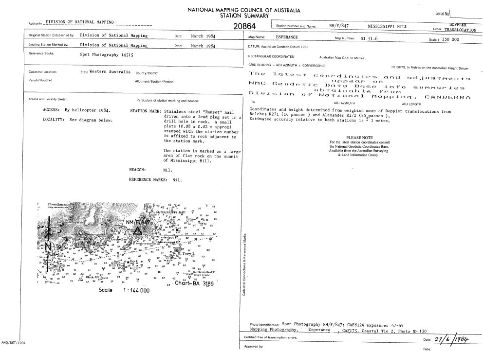
Mueller/Murphy helo to R272 Alexander, changed batteries/cassette and re-wound clock on time switch on Mini-Ranger transponder. Then to NMF 843 Tagon Point, recovered MX1502 and returned to Duke of Orleans Bay. Dropped off used batteries and loaded fresh batteries. Then to NMVF 501 Broughton Island, established and marked station. Then to NMF 847 Mississippi Hill, established station, set up MX1502 and marked for spot photography. Airborne, climbed to 4 000 feet and spot photographed station. Then to NMVF 501 Broughton Island, spot photographed from 4 000 feet. Returned to Duke of Orleans Bay.
Starkey airborne at Duke of Orleans Bay and successfully tested Mini-Ranger.
Mueller/Blanchfield helo to R271 Belches, completed SRV’s to NMVF 500.
Wise/Yates helo to R272 Alexander, completed SRV’s to NMVF 500.
Starkey/Murphy helo to NMVF 500, measured Mini-Ranger distances to R271 Belches and R 272 Alexander.
All parties returned to Duke of Orleans Bay.
TOTAL FLYING TIME THIS DAY: 6 hrs 27 mins.
Sunday 11 March 1984
Stand down; no flying this day.
Starkey attempted to repair radio.
TOTAL FLYING TIME THIS DAY: 0 hrs 00 mins.
Monday 12 March 1984
0630hrs at Duke of Orleans Bay.
Phoned Canberra to request bottle inflated 3-4 man life raft.
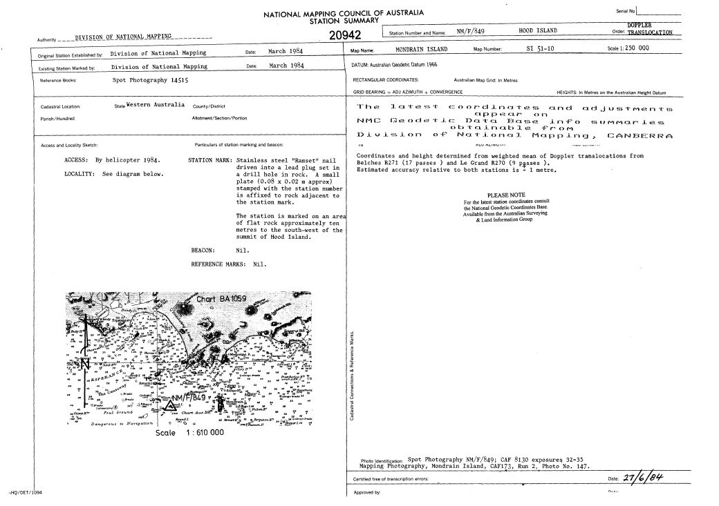
0715hrs; Mueller/Murphy helo to R271 Belches; changed batteries on MX1502. Then to NMF 846 Beaumont Island and recovered MX1502. Then to NMF 849 Hood Island, established station, set up MX1502 and marked for spot photography. Then to NMF 848 Finger Island, picked up MX1502. Then to Lucky Bay camp site where dropped off 4 used batteries, picked up 2 fresh batteries and refuelled. Then to NMF 851 Gunton Island, established station, marked for spot photography. Then to Lucky Bay camp site where dropped off 2 used batteries, picked up 2 fresh batteries and refuelled. Then to NMF 847 Mississippi Hill and recovered MX1502. Then to Lucky Bay camp site where dropped off 2 used batteries, picked up 2 fresh batteries. Then to Hendy Island; found to be quite unsuitable for MX1502 occupation as leading edge of breaking wave reached skids of helo; quickly aborted landing. Then to R270 Le Grand, set up MX1502. Then to Esperance6 Saddleback, recced helo landing site. Then returned to Duke of Orleans Bay.
Wise/Yates helo to R272 Alexander; recovered MX1502. Then NMVF 500 Legzde Island for spot photography, but camera malfunction forced abort.
Blanchfield/Mueller drove from Duke of Orleans to Esperance6 Saddleback.
Wise/Yates helo to R271 Belches.
Starkey/Murphy to NMVF 501 Broughton Island; observed SRV’s, horizontals and Mini-Ranger distances around this triangle.
0900 hrs; Yates/Templeman picked up inflatable life raft from Esperance. Then to Esperance airfield; collected 2 drums of ATK. Delivered fuel drums and 4 fresh batteries to Lucky Bay, then returned to Duke of Orleans Bay.
Chip detector for Bell 206 arrived from Alice Springs after fuel filter problem arose with Bell 206.
TOTAL FLYING TIME THIS DAY: 4 hrs 58 mins.
Tuesday 13 March 1984
0630hrs at Duke of Orleans Bay.
0800hrs; Hill-Smith/Yates to Esperance and attempted repairs of pop-out float mechanism on Bell 206.
Templeman/Mueller/Blanchfield/Wise/Starkey/Murphy drove to Lucky Bay to commence setting up camp site.
Hill-Smith/Yates in Esperance; repaired pop-out float mechanism.
Templeman/Mueller/Starkey returned to Duke of Orleans Bay via Esperance6 Saddleback. Attempted to recalibrate Mini-Ranger system, but results inconclusive.
TOTAL FLYING TIME THIS DAY: 0 hrs 00 mins.
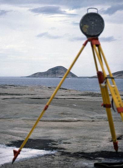
At R272 Alexander trig in 1973, whilst based at Esperance undertaking terrain profiling operations (courtesy Paul Wise).
Wednesday 14 March 1984
0710hrs at Duke of Orleans Bay.
Blanchfield/Starkey helo to R271 Belches with Mini-Ranger console, transponders, batteries etc.
Wise/Yates to R272 Alexander with 2 transponders; field calibrated Mini-Ranger system; NMVF 500 Legzde Island spot photographed. Then to ESP6 Saddleback, spot photographed and returned to Duke of Orleans Bay.
Helo back to R271 Belches; picked up Blanchfield/Starkey and Mini-Ranger gear, then returned to Duke of Orleans Bay.
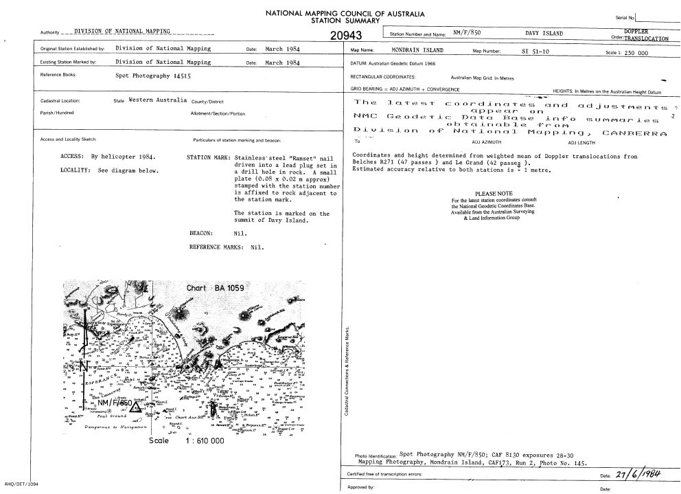
Blanchfield/Yates helo from Duke of Orleans Bay to NMF 849 Hood Island; recovered MX1502, found antenna leaning due to strong winds but still standing. Then to NMF 850 Davy Island; established station, set up MX1502; marked station for spot photography. Then to NMF 851 Gunton Island; recovered MX1502. Then returned to Lucky Bay; unloaded MX1502/batteries/marking gear etc.
Blanchfield/Yates helo from Lucky Bay to R270 Le Grand and set up for SRV’s; helo returned to Lucky Bay.
Wise/Murphy helo from Lucky Bay to Remark Island (RAN); completed SRV’s to R270 Le Grand and SEV’s (Single Ended Vertical angles) to NMF 690 Helby Island. Then to Hastings Island (RAN) and completed SRV’s to R270 Le Grand. Then to Mondrain Island (RAN) where attempts to climb a very large boulder to access the station mark were unsuccessful – ladder/ropes required; established temporary station close to south west of summit and completed SRV’s to R270 Le Grand; returned to Lucky Bay at 1530hrs, where met Mueller/Starkey who had picked up freighted replacement helicopter radio plus other stores. (Later : Returned to Mondrain Island (RAN) with ladder strapped to skids to enable access to station mark and carry out eccentric mark survey connection).
Temporary repairs to wind damaged marquees/Kimberley tents at Lucky Bay camp site. Mueller/Starkey/Wise/Murphy returned to Duke of Orleans Bay by vehicle.
Helo to R270 Le Grand; picked up Blanchfield/Yates and returned to Duke of Orleans Bay.
Murphy departed Duke of Orleans Bay at 2030hrs to pick up life raft from Esperance Hotel, but all that had arrived was an envelope containing 3 drill bits, mail and payslips; returned to Duke of Orleans Bay at 2230hrs.
TOTAL FLYING TIME THIS DAY: 4 hrs 51 mins.
Thursday 15 March 1984
0700hrs at Duke of Orleans Bay.
Very strong winds all morning from the north; no flying.
Blanchfield to Esperance to pick up 3-4 person life raft freighted from Canberra.
1325hrs; Wise/Templeman airborne; spot photographed the following :
. R270 Le Grand (5 000 feet)
. Remark Island (RAN) (4 000 feet)
. Hastings Island (RAN) (4 000 feet)
. Davy Island NMF 850 (4 000 feet)
. Hood Island NMF 849 (4 000 feet)
. Gunton Island NMF 851 (4 000 feet)
Stand down; heavy winds at midnight.
TOTAL FLYING TIME THIS DAY: 1 hr 24 mins.
Geodimeter reflector at NMF 844 Tizard Island during distance measurement from NMF 845 Marts Island, the peak at centre frame (courtesy Paul Wise).
Friday 16 March 1984
0710hrs at Duke of Orleans Bay.
Blanchfield/Starkey attempted helo to R271 Belches but forced to abort due to very heavy rain storm.
Wise/Yates drove to NMF 843 Tagon Point.
0800hrs; Blanchfield/Starkey helo to R271 Belches; helo returned to Duke of Orleans Bay.
Mueller/Murphy helo to NMF 448 Wedge Island thence to NMF 843 Tagon Point.
Helo then picked up Wise/Yates plus equipment and flew them to NMF 690 Helby Island.
Blanchfield/Starkey observed horizontals at R271 Belches to NMF 448 Wedge Island.
Mueller/Murphy observed SRV’s from NMF 448 Wedge Island to R271 Belches and NMF 690 Helby Island; many rain squalls crossed lines.
Mueller/Murphy completed horizontals at NMF 448 Wedge Island to NMF 690 Helby Island, RO R271 Belches.
Mueller/Murphy attempted Geodimeter measurements from NMF 448 Wedge Island to R271 Belches and NMF 690 Helby Island; forced to abort due to very strong winds (>30 Knots).
Mueller/Murphy helo from NMF 448 Wedge Island to R272 Alexander; showed light to NMF 690 Helby Island for horizontals; complete SRV’s R272 Alexander-NMF 690 Helby Island.
Mueller/Murphy helo from R272 Alexander to NMF 843 Tagon Point; picked up International; drove to Duke of Orleans Bay from Tagon Point.
Helo refuelled then to NMF 690 Helby Island, picked up Wise/Yates, then to NMF 448 Wedge Island; recovered light and returned to Duke of Orleans Bay.
TOTAL FLYING TIME THIS DAY: 3 hrs 12 mins.
Saturday 17 March 1984
0700hrs at Duke of Orleans Bay.
Mueller/Murphy helo to R271 Belches; set up observing screen for Geodimeter measurement.
Wise/Yates helo to NMF 448 Wedge Island; set up Geodimeter reflectors.
Mueller/Murphy completed two Geodimeter measurements, with difficulty, from R271 Belches to NMF 448 Wedge Island.
Wise/Yates helo from NMF 448 Wedge Island to Duke of Orleans Bay.
Mueller/Murphy helo from R271 Belches to Duke of Orleans Bay (2 trips) with all equipment.
Starkey fitted Mini-Ranger console and transponder to Bell 206.
Starkey/Murphy helo to Mondrain5 Draper Island; set up transponder on time switch; completed Mini-Ranger fixes at the following locations :
. Sulphur Reef
. Foam Rocks
. Matthew Rock (difficult to locate)
. Recherche Rock
. Tizard Island (NMF 844 Tizard Island, check measurement)
Starkey/Murphy helo to R272 Alexander; picked up transponder and then returned to Duke of Orleans Bay.
TOTAL FLYING TIME THIS DAY: 3 hrs 10 mins.
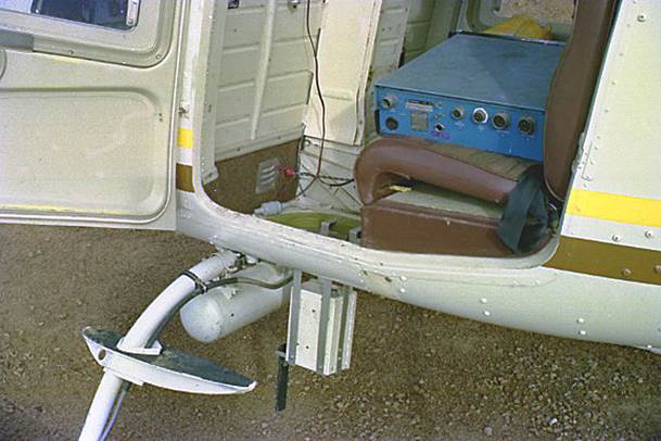
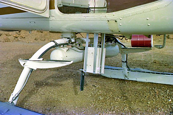
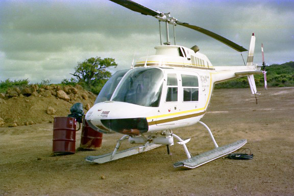
Mini-Ranger installation in Bell 206 Jet Ranger helicopter at Lucky Bay (courtesy Brian Murphy);
reversed Mini-Ranger transponder unit below cabin with master control console on cabin rear seat; more photographs at Attachment B.
Sunday 18 March 1984
0700hrs at Duke of Orleans Bay.
Packed up all equipment; cleaned house.
Wise/Templeman/Mueller/Yates departed Duke of Orleans Bay around 1000hrs in 3 vehicles for Lucky Bay camp site. Re-established camp site following severe overnight winds and heavy rain which damaged several tents. Large marquee suffered most damage with several large tears. Two Kimberley tents suffered minor damage - broken cross-trees. Minor damage to small marquee.
Murphy completed low level, hand-held, oblique Hasselblad photography of Duke of Orleans Bay camp site (door off).
Blanchfield helo to R271 Belches; changed batteries and cassette on MX1502 receiver and recovered Mini-Ranger transponder; helo to Lucky Bay camp site.
Starkey/Murphy drove from Duke of Orleans Bay to Lucky Bay camp site in hire car. All personnel involved in setting up Lucky Bay camp site.
1500hrs; Mueller/Murphy helo to Mondrain Island (RAN) (borrowed ladder, determined to be necessary to access station mark at Mondrain Island on 14 March, taken to site) completed SRV’s to Hastings Island (RAN) and Remark Island (RAN).
Wise/Yates helo to Hastings Island (RAN); completed SRV’s to Mondrain Island (RAN) and Remark Island (RAN).
Blanchfield/Starkey helo to Remark Island (RAN); completed SRV’s to Mondrain Island (RAN) and Hastings Island (RAN). Then helo to R270 Le Grand; completed SRV’s to Mondrain Island (RAN).
All returned to Lucky Bay.
TOTAL FLYING TIME THIS DAY: 4 hrs 02 mins.
Monday 19 March 1984
0700hrs at Lucky Bay.
Blanchfield/Wise helo to Termination Island (RAN); set up MX1502; returned to Lucky Bay.
Mueller/Yates helo to Bravo, Figure of Eight Island; set ecce on line to Remark Island (RAN), set up MX1502 and returned to Lucky Bay.
Blanchfield/Murphy to Wireless Hill by road.
Wise/Yates to NMVF 502 Observatory Point by road.
Mueller/Starkey to NMVF 503 Charnley Island; observed horizontals/SRV’s/Mini-Ranger measurements around this triangle. Airborne, hovered over Wireless Hill and observed Mini-Ranger distance to NMVF 502 Observatory Point; returned to Lucky Bay.
Wise/Yates and Blanchfield/Murphy returned to Lucky Bay by road.
TOTAL FLYING TIME THIS DAY: 3 hrs 13 mins.
Tuesday 20 March 1984
0700hrs at Lucky Bay.
Rain all day; stood down to 1330hrs.
Yates/Starkey to R271 Belches to check status of MX1502 receiver; batteries OK but cassette full; returned to Lucky Bay collected new cassette and then drove back to R271 Belches to change cassette.
TOTAL FLYING TIME THIS DAY: 0 hrs 00 mins.
Wednesday 21 March 1984
0700hrs at Lucky Bay.
Mueller/Wise and Blanchfield/Starkey departed by vehicle for Wireless Hill.
Yates/Murphy helo to R270 Le Grand; completed RM survey and set light to Wireless Hill. Helo to Cull Island (formerly named Gull Island); set lights to Wireless Hill and Bravo, Figure of Eight Island; set Geodimeter reflectors. Then to NMF 852 Boxer Island; established station.
At Wireless Hill Mueller/Wise observed horizontals/SRV’s and Geodimeter distance to NMF 852 Boxer Island, but unable to measure to Bravo, Figure of Eight Island. SRV’s observed :
. Wireless Hill-NMF 852 Boxer Island
. Wireless Hill-Bravo, Figure of Eight Island
. Bravo, Figure of Eight Island-NMF 852 Boxer Island
Yates/Murphy observed horizontal angle subtended at NMF 852 Boxer Island by Bravo, Figure of Eight Island and Wireless Hill.
Blanchfield/Starkey at Bravo, Figure of Eight Island; connected to new light house; observed horizontals to Cull Island, NMF 852 Boxer Island and Wireless Hill; observed SRV’s; set reflectors for Geodimeter measurement.
Mueller/Wise delivered Geodimeter to NMF 852 Boxer Island; Yates/Murphy measured to Bravo, Figure of Eight Island.
Mueller/Wise to Fur Rocks; observed SRV’s and horizontals to NMF 852 Boxer Island and Bravo, Figure of Eight Island; returned to Wireless Hill.
Blanchfield/Starkey helo to Mondrain6 but unable to land and returned to Wireless Hill.
Yates/Murphy helo to R270 Le Grand; recovered MX1502; returned to Lucky Bay.
TOTAL FLYING TIME THIS DAY: 6 hrs 08 mins.
Thursday 22 March 1984
0700hrs at Lucky Bay.
Mueller/Yates helo to R271 Belches; recovered MX1502; completed check survey of MX1502 ecce.
Mueller/Yates and Wise/Blanchfield in International D1300’s to B370 Wylie Bay and Esperance51. Rear oil seal fails in Blanchfield’s D1300; Esperance51 therefore not occupied. Mueller/Wise drove on to B370 Wylie Bay.
Starkey/Murphy helo to Termination Island (RAN); recovered MX1502; observed directions to Mondrain Island (RAN), Brown Reef, Little Island and un-named reef north of Little Island. Observed SRV’s from Termination Island (RAN) to Mondrain Island (RAN), Twin Rocks and Little Island; returned to Lucky Bay.
Helo to R270 Le Grand where :
. set up reflectors to B370 Wylie Bay
. set up for SRV’s to B370 Wylie Bay
. set lights on line to Wireless Hill and B370 Wylie Bay
Thence helo spot photography of following, all at 4 000 feet (except Wireless, 2 000 feet) :
. Giant Rocks (short strip)
. Mondrain6
. Bravo, Figure of Eight Island
. Fur Rocks
. NMF 852 Boxer Island
. NMVF 502 Observatory Point
. NMVF 503 Charnley Island
. Cull Island
. Wireless Hill
Helo returned to Lucky Bay; loaded Mini-Ranger equipment.
Helo to Mondrain Island (RAN); spot photographed from 4 000 feet. Then helo to Mondrain5 Draper Island; spot photographed and then landed to check batteries and rotate transponder. On to Mondrain4 Pearson Island; landed, set up transponder and marked for spot photography. Helo to Mondrain3; unable to land. Then helo to Mondrain2; landed; set up transponder and marked for spot photography (whitewash). Helo to un-named rocks south of Mondrain Island; fixed by Mini-Ranger. Then vicinities of Dalrymple and Dampier Rock but could not locate and complete Mini-Ranger fixes; returned to Lucky Bay.
TOTAL FLYING TIME THIS DAY: 5 hrs 22 mins.
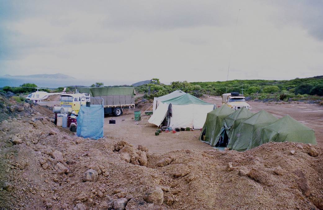
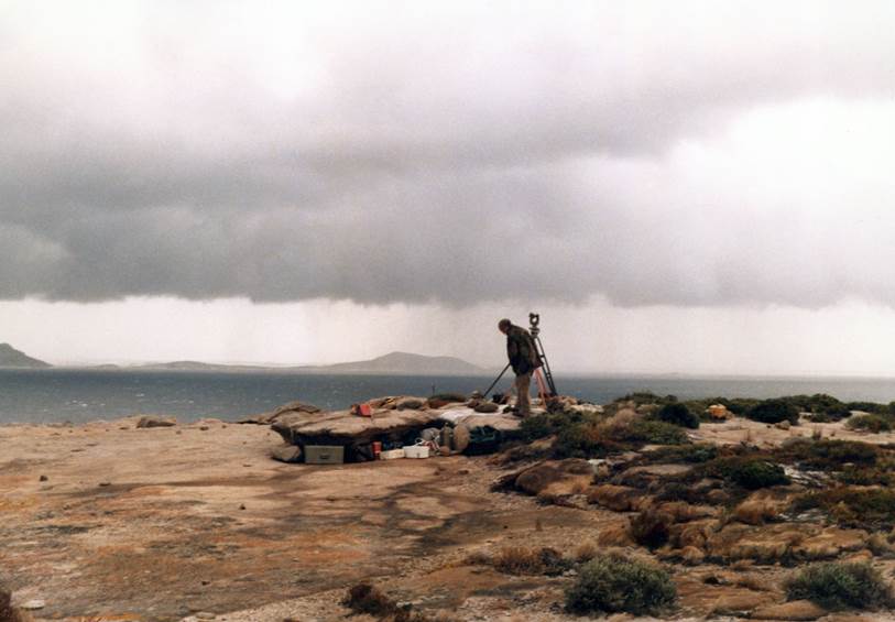
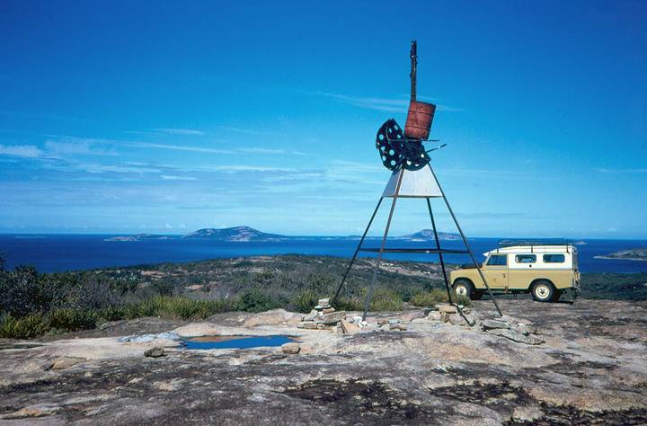
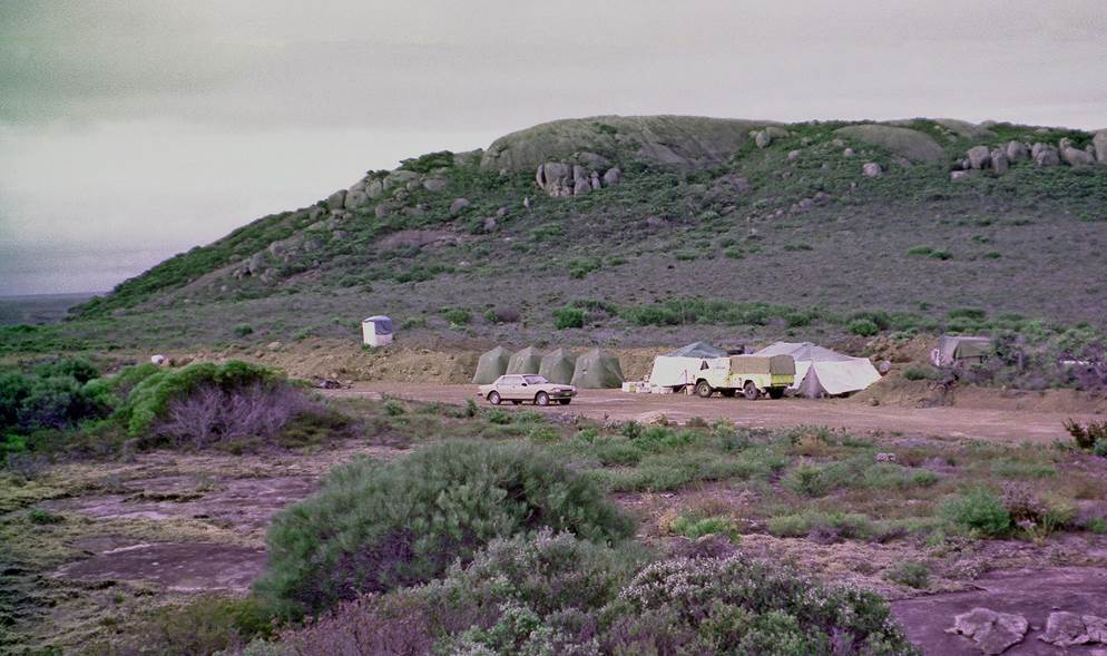
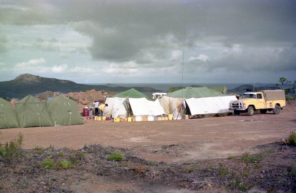
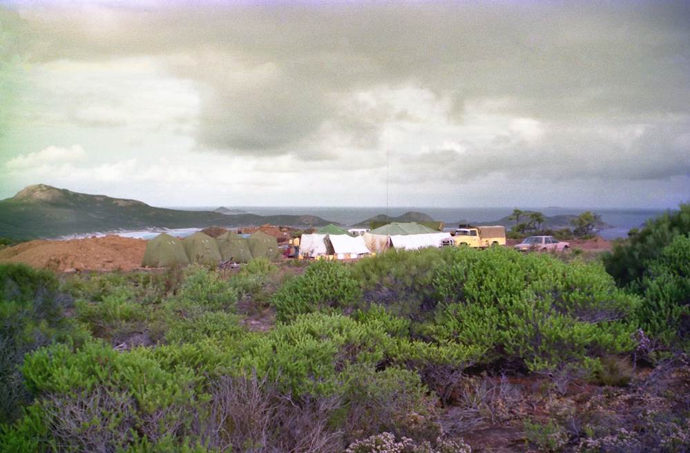
Lucky Bay camp site, looking south, with Mondrain Island in the distance (courtesy Brian Murphy);
more photographs at Attachment C.
Friday 23 March 1984
0740hrs at Lucky Bay.
All except Starkey/Murphy packing up Lucky Bay camp site.
Starkey/Murphy helo to Mondrain5 Draper Island; recovered Mini-Ranger transponder; to Mondrain4 Pearson Island; landed and rotated transponder; to Mondrain2; landed and set up transponder; to Mondrain1; landed and set up transponder. Then to un-named reef north of Termination Island; completed Mini-Ranger fix (helo drifted westwards during fix); to un-named reef some 5 kilometres SSE of Mondrain2 (not shown on chart/map); completed Mini-Ranger fix. Then to Mondrain1; recovered transponder.
Helo to Lucky Bay; unloaded Mini-Ranger equipment; installed Hasselblad camera.
Blanchfield/ Murphy helo to :
. Mondrain1 (spot photographed 4 000 feet)
. Mondrain2 (spot photographed 4 000 feet)
. Mondrain3 (spot photographed 4 000 feet & 1 500 feet)
Helo to Mondrain2; recovered transponder; then to Mondrain4 Pearson Island; recovered transponder; spot photographed from 4 000 feet. Helo to Mondrain Island (RAN); spot photographed from 5 000 feet; returned to Lucky Bay.
All personnel evacuate Lucky Bay camp site at 1300hrs and move to accommodation at Esperance.
Due to fuel shortage Graeme Hill-Smith aborted plan to fly to Forrest this day, and instead flew to Esperance airstrip for fuel top-up (about 10 gallons required).
TOTAL FLYING TIME THIS DAY: 3 hrs 45 mins.
GRAND TOTAL FLYING HOURS ON SURVEY: 52 hrs 36 mins.
Saturday 24 March 1984
Whole party at Esperance.
Graeme Hill-Smith departed Esperance airstrip at 0600hrs for Ayers Rock in Bell Jet Ranger 206 VH-BKG.
Mueller/Yates/Templeman/Starkey departed Esperance for Canberra at 0930hrs by road.
Blanchfield/Wise/Murphy departed Esperance at 1900hrs by air for Perth/Melbourne/Canberra.
Outcomes
On return to Canberra, the distance and angle observations and digital Doppler survey data were processed by Frank Blanchfield, assisted by Maris Legzde. The survey results, being essentially coordinates and spot and aerial photo-identification of the required locations throughout the offshore map areas, were summarised as required on the National Mapping Council of Australia Station Summary form. These summaries may be accessed from the links in the Survey and Mapping Control List table below. The processed survey data then formed a significant part of the complete horizontal and vertical control requirement for the numerical (computer) adjustment of Nat Map’s Photogrammetric Block 46, please refer Attachment A. From the now controlled aerial photography, the detail for the requisite 1: 100 000 scale maps was accurately stereoplotted. The final 1: 100 000 scale line maps now depicted, for the first time, the majority of the islands and offshore features in this area in their true absolute and relative geographic locations.
Acknowledgement
In the years since this survey we have lost two of the survey party; Natmapper Noel Frederick Templeman (1944-2009) and contract helicopter pilot Graeme Hill-Smith (1935-2018). Their contribution to the success of the survey is hereby acknowledged.
Survey and Mapping Control List and Map of Locations
|
Survey and Mapping Control List |
|||
|
Existing Control Points |
Latitude |
Longitude |
Survey use/result |
|
R270 Le Grand |
-33.994 |
122.134 |
Doppler translocation base station |
|
R271 Belches |
-33.942 |
122.574 |
Doppler translocation base station & Mini-Ranger transponder site |
|
R272 Alexander |
-33.888 |
122.850 |
Doppler translocation base station & Mini=Ranger transponder site |
|
WIRELESS |
-33.879 |
121.889 |
Survey control station |
|
Esperance6 (ESP6) Saddleback |
-33.849 |
122.435 |
Mini-Ranger transponder site |
|
Esperance51 (ESP51) |
-33.828 |
121.942 |
Not occupied |
|
NMF 690 Helby Is |
-34.120 |
123.067 |
Mini-Ranger transponder site |
|
Mondrain1 (MDN1) |
-34.180 |
121.943 |
Mini-Ranger transponder site |
|
Mondrain2 (MDN2) |
-34.232 |
122.064 |
Mini-Ranger transponder site |
|
Mondrain3 (MDN3) |
-34.226 |
122.148 |
Unable to occupy |
|
Mondrain4 (MDN4) PEARSON IS |
-34.211 |
122.347 |
Mini-Ranger transponder site |
|
Mondrain5 (MDN5) DRAPER IS |
-34.197 |
122.495 |
Mini-Ranger transponder site |
|
Mondrain6 (MDN6) |
-34.043 |
121.604 |
Mini-Ranger transponder site |
|
REMARK IS |
-34.066 |
121.986 |
Height upgraded (by simultaneous reciprocal vertical angles) |
|
MONDRAIN IS |
-34.149 |
122.241 |
Height upgraded (by simultaneous reciprocal vertical angles) |
|
HASTINGS IS |
-34.098 |
122.117 |
Height upgraded (by simultaneous reciprocal vertical angles) |
|
FUR ROCKS |
-34.015 |
121.639 |
Height upgraded (by simultaneous reciprocal vertical angles) |
|
Existing Control Points Upgraded |
|||
|
TERMINATION IS |
-34.473 |
121.990 |
Doppler fix |
|
BRAVO (Figure of Eight Is) |
-34.018 |
121.609 |
Doppler fix |
|
B370 Wylie Bay |
-33.838 |
121.983 |
Geodimeter from R270 |
|
NMF 448 Wedge Is |
-34.090 |
122.832 |
Geodimeter from R271 |
|
Control Points Added During Survey |
|||
|
NMF 841 South Twin Peak Is |
-34.007 |
122.807 |
Doppler fix (accuracy ±1 metre) |
|
NMF 842 Westal Is |
-34.081 |
122.963 |
Doppler fix (accuracy ±1 metre) |
|
NMF 843 Tagon Point |
-33.891 |
122.974 |
Doppler fix (accuracy ±1 metre) |
|
NMF 846 Beaumont Is |
-34.092 |
122.536 |
Doppler fix (accuracy ±1 metre) |
|
NMF 847 Mississippi Hill |
-33.995 |
122.253 |
Doppler fix (accuracy ±1 metre) |
|
NMF 848 Finger Is |
-34.104 |
122.345 |
Doppler fix (accuracy ±1 metre) |
|
NMF 849 Hood Is |
-34.146 |
122.053 |
Doppler fix (accuracy ±1 metre) |
|
NMF 850 Davy Is |
-34.136 |
121.933 |
Doppler fix (accuracy ±1 metre) |
|
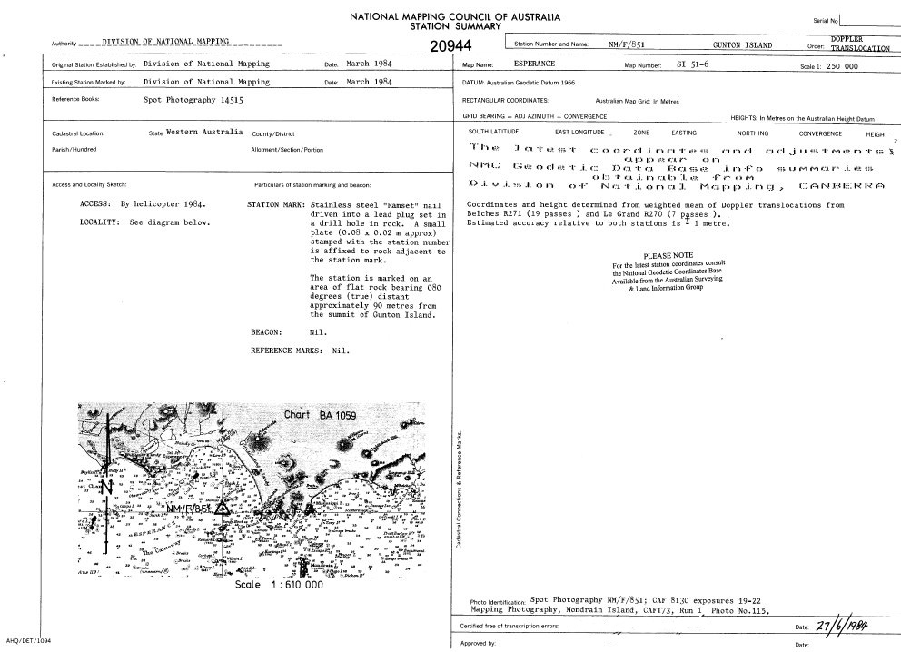
NMF 851 Gunton Is |
-33.988 |
121.996 |
Doppler fix (accuracy ±1 metre) |
|
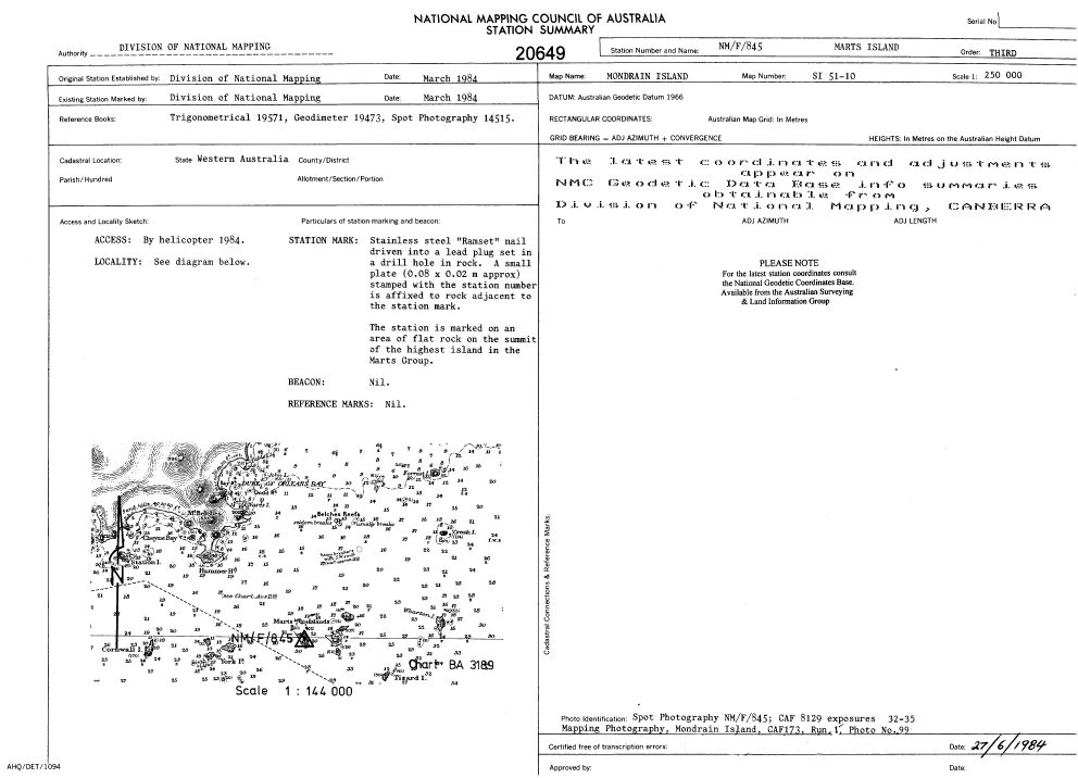
NMF 845 Marts Is |
-34.001 |
122.631 |
Geodimeter from R271 and NMF 844 |
|
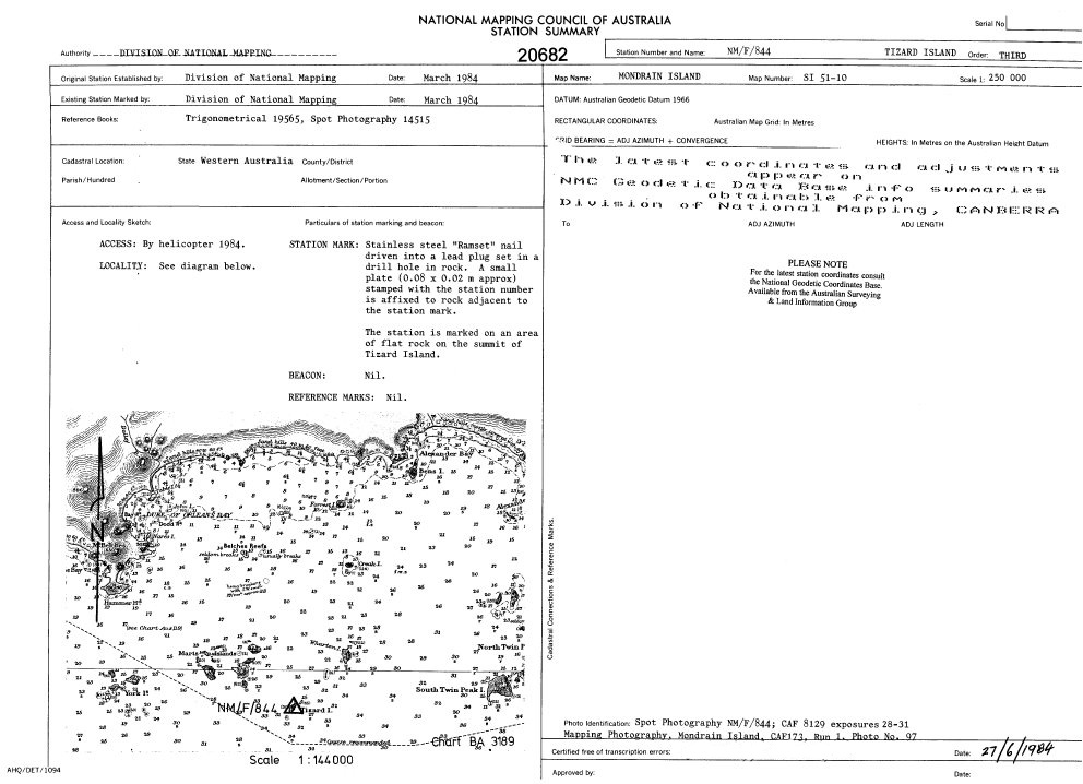
NMF 844 Tizard Is |
-34.018 |
122.682 |
Geodimeter from NMF 845 and Mini-Ranger fix |
|
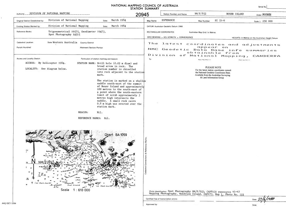
NMF 852 Boxer Is |
-34.001 |
121.677 |
Geodimeter from WIRELESS and BRAVO |
|
Cull Is (formerly Gull Is) |
-33.920 |
121.900 |
Geodimeter from WIRELESS |
|
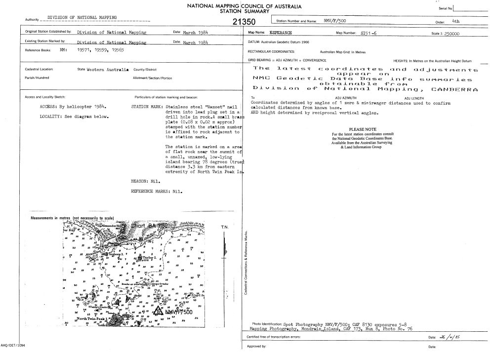
NMVF 500 (unofficially Legzde Is) |
-33.978 |
122.896 |
Geodimeter from R271 and R272 |
|
NMVF 501 Broughton Is |
-33.980 |
122.430 |
Mini-Ranger distances from ESP6 and R271 |
|
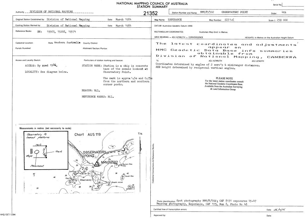
NMVF 502 Observatory Point |
-33.909 |
121.795 |
Mini-Ranger distances from WIRELESS |
|
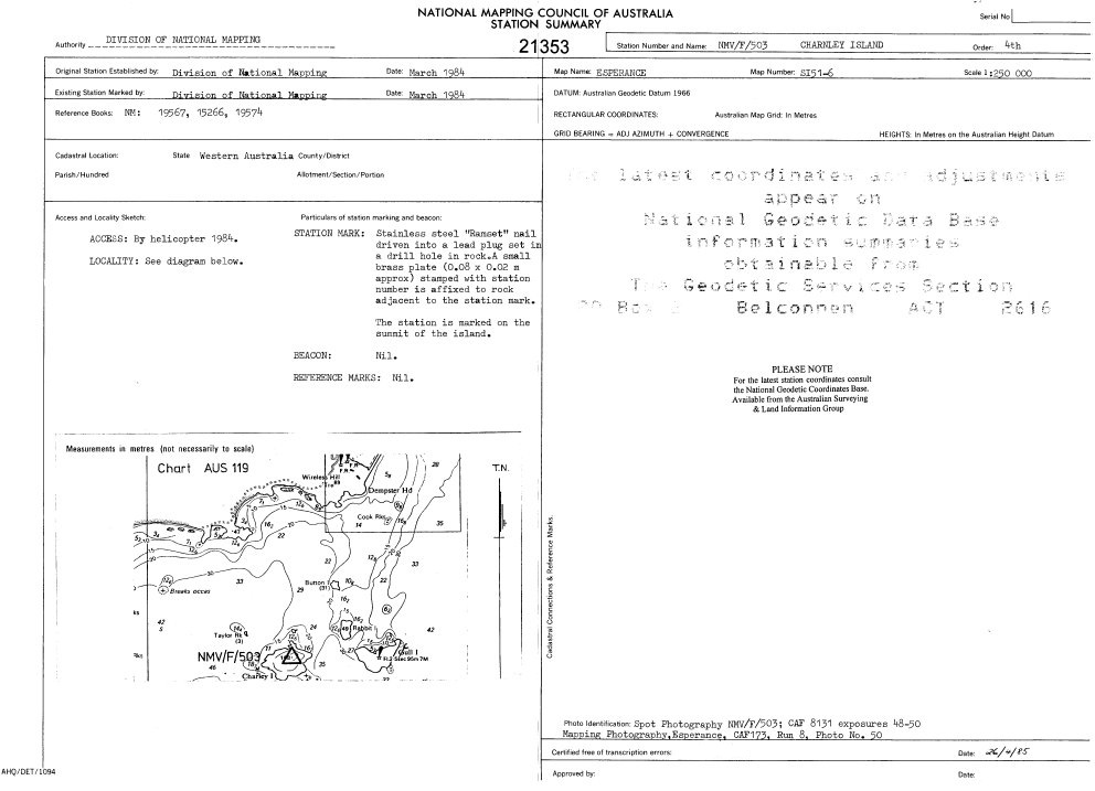
NMVF 503 Charnley Is |
-33.922 |
121.875 |
Mini-Ranger distances from WIRELESS and NMVF 502 |
|
Sulphur Reef |
-34.120 |
122.670 |
Mini-Ranger fix |
|
Foam Rocks |
-34.120 |
122.840 |
Mini-Ranger fix |
|
Matthew Rock |
-34.190 |
122.990 |
Mini-Ranger fix |
|
Recherche Rock |
-34.290 |
122.900 |
Mini-Ranger fix |
|
Note : Along all Geodimeter and required Mini-Ranger lines, horizontal angles for azimuth and simultaneous reciprocal vertical angles for height, were observed. Individual hyperlinks allow the applicable National Mapping Council Station Summary to be viewed. |
|||
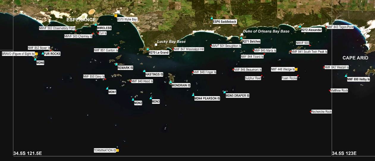
Map of the Archipelago of the Recherche survey area showing the locations of all the control mentioned above;
existing (light blue triangles), upgraded (orange squares), fixed during this survey (red dots); helicopter bases (white squares);
a zoomable version is available at this link, courtesy Paul Wise.
Diagram Showing National Mapping’s Photogrammetric Blocks
|
Additional Photographs of Motorola Mini-Ranger Installation in Bell 206 Jet Ranger, at Lucky Bay Camp (courtesy Brian Murphy) |
|
|
|
|
|
Mini-Ranger transponder mounting under cabin. |
Mini-Ranger transponder mounting straps. |
|
|
|
|
Geoff Starkey with Mini-Ranger installation, and connection cabling. |
Mini-Ranger installed but not connected. |

|
Additional Photographs of Lucky Bay Camp (all except last, courtesy Brian Murphy) |
|
|
|
Lucky Bay camp site, looking north-west, with Frenchman Peak in the background. |
|
|
|
Lucky Bay camp site, looking south-east to Mississippi Hill. |
|
|
|
Lucky Bay camp site, looking south-east to Mississippi Hill. |
|
|
|
Lucky Bay, Cape Le Grand National Park, across to Mississippi Hill |