Edward Percival Bayliss FRGS (1887-1957)
National Mapping’s First Chief Cartographer 1947-1950
By Laurie McLean November 2019
(updated in November 2020)
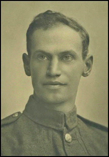
Edward Percival Bayliss circa 1916.
Ancestor.com image.
English-born Edward Percival Bayliss undertook an Elementary Drawing Certificate course during 1901-1903 and went on to become a professional draftsman. During World War I he served in France as a Sapper with the British Army’s Royal Engineers. In 1921, Percival Bayliss was elected a Fellow of the Royal Geographical Society. In 1923 EP Bayliss and his family immigrated to Australia. After initially living in Melbourne he took up a position as a draftsman with the Lands and Surveys Branch of the Commonwealth Department of Works and Railways in December 1927.
The Bayliss family lived in Canberra from at least 1929. Here Edward Percival Bayliss became internationally renowned for his work on the Australian sheets in the 1:1 Million scale International Map of the World series as well as numerous other significant map projects. By the end of the 1930s EP Bayliss was classified as a cartographer within the Department of the Interior. In Canberra during the 1930s EP Bayliss was an active member of ex-service persons organisations.
In April 1947, a few days before his 60th birthday EP Bayliss was appointed Chief Cartographer in the fledgling National Mapping Section of the Department of the Interior and retired from that position in January 1950.
From family notices in the daily press, EP Bayliss was known as Percival. Former Assistant Director John Dunstan Lines joined the National Mapping Section as a Draftsman, Grade 2 in August 1948. In his 1992 book, Australia on Paper: The Story of Australian Mapping, Joe Lines also referred to EP Bayliss as Percival.
This article seeks to provide a biographical outline of Nat Map’s first Chief Cartographer. Unfortunately, following initial research for the article many gaps remained in Percival Bayliss’s story. Recently, his grandson Dr Bruce Ryley an anaesthetist, has helped to fill some of those gaps. In what follows it is hoped that the reader will glean some useful insights into the life and work of Edward Percival Bayliss. Some additional information, although to some extent peripheral, is included for completeness and to ensure that some related research results were not simply discarded.
Parents and siblings
Edward Percival Bayliss was born on 21 April 1887 in the English university city of Oxford about 80 kilometres north west of London. He was baptised in Oxford on 10 July 1887. Percival was the second of the three children born to Albert Edward Bayliss (circa 1863‑1938) and his wife Adelaide Sarah Bayliss née Beckley (circa 1860‑1942). Percival’s parents Albert and Adelaide married in the St Mary and St John Church in Cowley Road East Oxford on 15 April 1884. Albert Bayliss’s occupation in England was variously listed as a letter carrier or as a postman.
Percival Bayliss’s elder sibling was his sister Hilda Lilian who was born in Oxfordshire on 25 January 1885. Sadly, Hilda died in Oxford in 1888 at 3 years of age. Percival’s younger sibling was his sister Elsie Adelaide who was born in Oxford on 17 February 1891. Elsie was baptised in Oxford on 3 May 1891.
In 1901, around the time he turned 14 years of age, Edward Percival Bayliss commenced a 2-year course in elementary drawing at the Training College in the Science and Art Department, under the Board of Education at South Kensington in London. The Science and Art Department was located in the Henry Cole Wing of the Victoria and Albert Museum in Exhibition Road South Kensington. When Percival Bayliss commenced this course, the Director of the Science and Art Department and Principal of the Training College was Sir William Abney (1843-1920).
Depending on which course they took, students at the Science and Art Department were eligible for either an Elementary Drawing Certificate or a Training College Drawing Certificate. Each course of instruction was over 2 years. Students in both of these courses were instructed in drawing with chalk on the blackboard. In the Elementary course, instruction was also given in model drawing, drawing in light and shade from a cast, geometrical drawing (art), and perspective.
At age 16 years, Edward Percival Bayliss was granted Elementary Drawing Certificate, number 120, by the Board of Education, South Kensington on 12 November 1903. He had passed examinations in the 5 subjects mentioned above. A copy of Percival Bayliss’s Drawing Certificate and further information on the Science and Art Department and on Sir William Abney are provided at Appendix A.
1911 United Kingdom Census
In a 1911 UK Census record, Percival Bayliss’s parents and other family members were listed as residing at 46 Chilswell Road Oxford (South Ward). Listed were: Albert, age 48 years, retired town postman; Adelaide, age 51 years, retired; Elsie, age 20 years; and Horace William Frederick Bayliss, age 26 years, college servant (nephew). Percival was not listed at that address, so presumably by then at circa age 24 years he was living away from his parents.
Marriage to Lavinia Moneypenny 1913
On 21 June 1913 Edward Percival Bayliss and Lavinia Blanche Moneypenny married at Brixton Hill about 6 kilometres south of the City of London. The marriage was solemnized at the St Saviour’s Church in Herne Hill Road Brixton Hill. In an 1891 UK Census record, Lavinia was listed as the second of five children then born to James Moneypenny (born 1850) and his wife Mary Moneypenny née Miller (born 1854). James was a boiler smith by trade. Lavinia Moneypenny was born in Chiswick, West London in 1886; at the time of her wedding she was 27 years of age. On the marriage register Edward Bayliss was listed as a 26-year old draftsman residing at Brixton Hill.
Birth of daughter 1914
The birth of Percival and Lavinia Bayliss’s only child, their daughter Doris, was registered in the England and Wales Civil Birth Registry during the quarter ending June 1914. The birth register did not record the actual date of birth but, from other sources, she was born on 10 April 1914. Doris’s birth was registered in the Lambeth district, a borough in South London extending from the Thames through Brixton to Streatham Common about 7 kilometres south of the River.
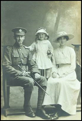
Bayliss family circa 1916, L-R: Percival, Doris, and Lavinia.
Ancestor.com image.
On 12 July 1914, Doris Bayliss was baptised in St Mathew’s Church of England on the corner of St Mathew’s and Effra Roads in Brixton. The baptism register showed that at that time Percival’s occupation was draftsman and that he and Lavinia resided at 55 Kellett Road Brixton; which joins Effra Road opposite St Mathew’s Church. A recent image of 55 Kellett Road is provided below.
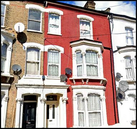
Recent view of 55 Kellett Road Brixton where Percival Bayliss lived in 1914.
Google Street View image March 2019.
World War I service with Royal Engineers
Just 23 days after the baptism of Doris Bayliss, Britain declared war on Germany. This declaration, which was published in a Supplement to The London Gazette on Tuesday 4 August 1914, was against a background of other hostilities in Europe. It followed from the German invasion of Belgium on the previous day. The British declaration of war was in compliance with Britain’s obligations in the 1839 Treaty of London under which it would assist Belgium in the event of a German attack. During the First World War that was to follow, Percival Bayliss served as a Sapper in the British Army’s Corps of Royal Engineers; Regimental Number 264479.
Percival Bayliss enlisted in the Royal Engineers on 11 December 1915 at age 28 years and served in France with the rank of Sapper during World War I. He was demobilised in 1919. As a result of his War service, Percival was awarded the British War Medal (1914-1918) and the Allied Victory Medal (1914-1919) see Appendix B for more information.
Living in Harrow early 1920s
After World War I, Percival and Lavinia Bayliss were next identified on electoral registers for 1921 and 1923. Here they were both listed as residing at 76 Butler Road Harrow, about 20 kilometres north west of the City of London.
Fellow of the Royal Geographical Society 1921
On 21 November 1921, Edward Percival Bayliss was elected a Fellow of the esteemed Royal Geographical Society in London. A copy of the Society’s letter of notification is provided below. As a Fellow of the Royal Geographical Society, Percival Bayliss was entitled to use the post-nominals FRGS.
The then Geographical Society of London was founded in 1830 to promote the advancement of geographical science. Under the patronage of King William IV, it became known as the Royal Geographical Society and a Royal Charter was granted by Queen Victoria in 1859. In 1913, the Society moved to its current premises at Lowther Lodge in Kensington Gore London, about 500 metres from the Victoria and Albert Museum. There are also Geographical Societies and Associations in numerous other countries including Royal Geographical Societies in Australia.
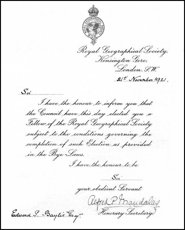
Copy of the letter from the Royal Geographical Society to Percival Bayliss in 1921.
Provided by Bruce Ryley.
Bayliss family immigrated to Australia 1924
During the 1920s, new immigration agreements were implemented between the State and Commonwealth Governments in Australia and between the British and Australian Governments. The Commonwealth Government became responsible for recruiting immigrants and for receiving immigration requisitions from State Governments, private employers and community organisations. The Commonwealth also became responsible for the medical examination of immigrants. Between 1921 and 1929 some 221 000 new settlers from Europe received passage assistance to Australia, about 75 per cent of which were British (Langfield, 1999).
In November 1919 Percival Bayliss’s sister Elsie had accompanied her Australian Imperial Force soldier husband John Brighton on his return from England and they both settled in Australia. John and Elsie Brighton travelled to Australia on the SS Ormonde. In December 1923 the extended Bayliss family departed London to immigrate to Australia. As detailed in the table below, the family comprised Percival, his wife Lavinia, their daughter Doris and Percival’s retired parents Albert and Adelaide. The family travelled to Australia as third class passengers which may indicate they were assisted migrants.
|
Name |
Age |
Occupation |
UK Residence |
Destination |
|
Bayliss, Edward P |
36 |
Draftsman |
All formerly |
Melbourne |
|
Bayliss, Lavinia |
37 |
Wife |
Of |
Melbourne |
|
Bayliss, Doris |
9 |
Nil |
76 Butler Road Harrow |
Melbourne |
|
Bayliss, Albert |
60 |
Retired |
East End, North Leigh |
Melbourne |
|
Bayliss, Adelaide |
64 |
Retired |
Mr Witney, Oxon |
Melbourne |
Bayliss Family passenger listing on SS Demosthenes 6 December 1923.
Source: UK Outbound Passenger List 1890-1960, London, 1923, December.
Percival Bayliss and his family left London on 6 December 1923 onboard the Aberdeen Line Steam Ship Demosthenes under Master William J Williams who was on his first voyage as captain of a passenger vessel. The ship was carrying a large number of immigrants bound for Australia. Further brief information on the Demosthenes and the Ormonde is provided in Appendix C.
En route to Australia the Demosthenes was quarantined at Cape Town due to several cases of influenza. She arrived at Albany in southern Western Australia on 14 January 1924 where some 260 new settlers were expected to disembark.
The Demosthenes then arrived at No 2 Victoria Dock on Melbourne’s Yarra River at about 4:00 pm on Saturday 19 January 1924. Here some 211 new settlers disembarked including former officers and experienced farm workers. The extended Bayliss family was among these new arrivals. Subsequently the Demosthenes departed Melbourne for Sydney on 24 January 1924.
Other Bayliss family members in Australia.
Some brief information on other Bayliss family members after their arrival in Australia is provided in Appendix D. This information pertains to Percival’s sister Elsie and her husband John Brighton, to Percival and Lavinia’s daughter Doris and her husband Thomas Frederick Ryley, as well as Percival’s parents Albert and Adelaide Bayliss.
Living in Melbourne 1920s
In January 1924, a few days after arriving in Melbourne, Percival Bayliss joined the Oakleigh sub-branch of the Returned Soldiers and Sailors Imperial League of Australia; the initial form of today’s Returned and Services League, Australia (RSL). On electoral rolls for 1925, 1926, 1927 and 1928 Edward Percival Bayliss and Lavinia Blanche Bayliss were listed as residing at Elouera in Brynmawr Road Camberwell (about 10 kilometres south east of the Melbourne central business district). Their respective occupations were listed as draftsman and home duties. During research for this article details of Percival’s initial employers in Melbourne were not discovered. (He was not listed as an employee in Victoria Government Gazettes between 1923 and 1927.)
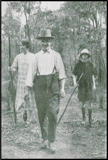
Bayliss family bush walking near Melbourne in the late 1920s.
From left: Lavinia, Percival, and Doris.
Bayliss family image from Bruce Ryley.
Service with Commonwealth Government Departments 1927-1950
For the last 22 years of his working life Edward Percival Bayliss was employed by the Commonwealth Government in Australia. His initial Commonwealth Government appointment was on probation to the new position of Draftsman, Division III (later Third Division) in the Lands and Surveys Branch (Central) of the Department of Works and Railways. This appointment was promulgated on page 441 of the Commonwealth of Australia Gazette, Issue 22 on 1 March 1928. In that Gazette notice the date of appointment was given as 3 January 1928. However, on page 935 of Gazette Issue No 45 of 10 May 1928, the date of appointment was amended to 20 December 1927.
It was not clear if Percival Bayliss was appointed to a Commonwealth Government position in Melbourne or in Canberra. (The Federal Parliament and the Commonwealth Government were based in Melbourne from 1901 until 1927 when the Parliament moved to Canberra.) In 1927 the central office of the Department of Works and Railways was located at Treasury Gardens in Melbourne. However, the Lands and Surveys Branch was located in both Melbourne and at Acton in Canberra.
In 1929 EP Bayliss was granted tenancy of a residential property in Canberra. Thus he and his family most likely had moved to Canberra by around that time. Also a report in The Canberra Times in October 1929 mentioned that Mr EP Bayliss had left for Melbourne on official duty (Anonymous 1929).
Living in Canberra 1929-1957
On 13 July 1929 Percival Bayliss was granted occupation of a house and land with a Commet garage under a tenancy lease agreement with the then Federal Capital Commission. The property was described as block 5, section 23, in division 13 and was located at 34 Coranderrk Street Reid (ArchivesACT, undated). During the initial years of Canberra’s development there were no grants of freehold land. Instead under The City Leases Ordinance 1921, the relevant Minister granted leases of land within the city area for periods not exceeding 99 years. Annual rentals were set at 5 per cent of the unimproved value of the land, with the value of the land being reappraised after 20 years.
Percival Bayliss was to reside at 34 Coranderrk Street until his death on 3 October 1957. Six days after Percival Bayliss’s death, occupation of property was granted to his widow Lavinia Blanche Bayliss. Lavinia held the property until April 1962 when it passed to another lease holder (ArchivesACT, undated). Lavinia Bayliss died in Brisbane in 1964 and had been living there with her daughter and son-in-law.
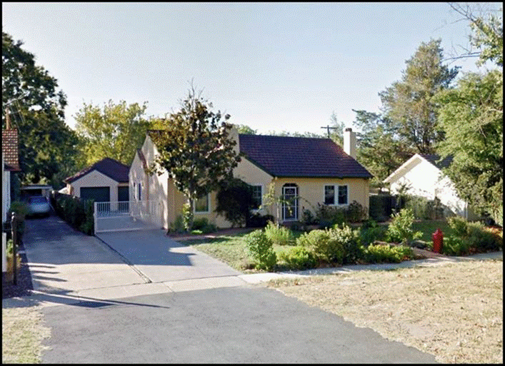
A recent image of the former Bayliss family home at 34 Coranderrk Street Reid.
Google Street View image March 2015.
Ex-service organisations involvement Canberra 1929-1930s
In Canberra from 1929, Percival Bayliss was an active member and office bearer in the Returned Soldiers' League and associated organisations including the then Imperial Ex-servicemen's sub-branch. Following its formation in 1916, the League has had several name changes and is now known as the Returned and Services League, Australia (RSL). Percival Bayliss joined the then Canberra sub-branch in 1929.
From 1932 to 1935, Percival Bayliss and Victor Oswald Samuels were the trustees of a distress fund that assisted needy ex-service families in the then Federal Capital Territory. In their report to the Returned Soldiers' League for the six months ending 11 July 1932, the two trustees advised that some 104 people had been assisted: 40 were assisted with food, 52 with clothing and 12 grants of cash were made. In their report the trustees thanked the Canberra Relief Society for valuable assistance and the Legacy Club for assistance in respect of widows of deceased soldiers (Anonymous, 1932A).
From 1932 to 1935, Percival Bayliss was involved in various management positions at the then Legacy Club of Canberra. The Club was founded in 1928 and remains dedicated to the care of dependents of Australian servicemen and women who died during or as a later result of service of their country. Percival Bayliss served on the Club’s board of management (1932-1934); welfare committee (1934); illustrator of the Monthly Bulletin (1932-1933) and joint editor of the Bulletin (1933).
In January 1932, Percival Bayliss was a founding member and the elected treasurer of the North Canberra sub-branch of the Returned Soldiers’ League (until then there were Canberra and Ainslie sub-branches) (Anonymous, 1932). In March 1935, Percival Bayliss was a founding member and the elected vice president of the Imperial Ex‑servicemen's sub-branch (Anonymous, 1935).
As well as undertaking the duties of the various offices he held in these ex‑service organisations, Percival Bayliss also undertook much illustrative work including on designs and certificates. Unfortunately in 1935, ill health forced Percival Bayliss to give up much of his ex service organisations activities (Bayliss, undated).
Department of the Interior 1932-1950
In April 1932 the Department of Works and Railways was abolished and the Lands and Survey Branch then became the Property and Survey Branch in the Department of the Interior. Percival Bayliss was to work in the new Department until his retirement in 1950.
At 30 June 1933, the Drafting Section of the Property and Survey Branch was led by Chief Draftsman Felix James Broinowski. As well as Percival Bayliss, draftsmen in the Drafting Section at that time included Francis Leslie Hatfield and others.
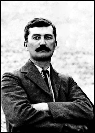
Felix Broinowski circa 1911.
XNatmap image.
Felix Broinowski (1873-1947) was first appointed to the Commonwealth Public Service on 19 January 1910. In the early 1890s Broinowski served as a Second Lieutenant in the Richmond River Half Squadron Cavalry Regiment (New South Wales colonial forces). Broinowski later served in the First Regiment of Australian Bushmen in South Africa (during the Boer War of 1899-1902); initially as a Sergeant and later as a Squadron Quartermaster Sergeant. Felix James Broinowski retired from the Department of the Interior on 11 October 1937 at age 64 years. He died at Wahroonga on 2 August 1947, at age 74 years.
Francis Leslie Hatfield (1885-1962) was first appointed to the Commonwealth Public Service on 16 October 1911. He had previously been a draftsman with Halloran and Company in Sydney for some 5 years. Hatfield enlisted in the Australian Imperial Force in August 1915 at age 29 years. He served in France as a Gunner (Service Number 7185) with the 13th Battery in the 5th Field Artillery Brigade (and also in other units) from February 1917 and returned to Australia in June 1919.
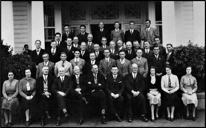
Property and Survey Branch staff at the Acton Offices circa 1935.
Percival Bayliss is in the front row, fourth from left next to Felix Broinowski (third left).
Bayliss family image provided by Bruce Ryley.
On 30 September 1937, with the retirement of Felix Broinowski pending, Frank Hatfield was promoted to Chief Draftsman, Third Division, in the Drafting Section of the Property and Survey Branch. Hatfield retired as Chief Draftsman on 29 November 1950; one day short of 65 years of age. Francis Leslie Hatfield died on 14 August 1962 at age 76 years. His remains were cremated in Sydney with a short graveside service held at Canberra Cemetery on 18 August 1962.
On 23 July 1936, Percival Bayliss was promoted to the newly-created position of Draftsman, Grade 2, Third Division, in the Drafting Section of the Property and Survey Branch. This promotion was promulgated on page 1355 of Commonwealth of Australia Gazette, Issue No 59 of that date.
In September 1938 Percival Bayliss was promoted to the newly created position of Cartographer, Third Division, in the Drafting Section of the Property and Survey Branch. This promotion was promulgated in Commonwealth of Australia Gazette, Issue No 52 of 1 September 1938 on page 2161.
By the late 1940s, at least, the Drafting Section of the Property and Survey Branch had been re-designated as the Drafting and Plan Printing Section.
Relief Model of Antarctica 1934
While the relief model was prepared by the Department of the Interior, it was funded by Melbourne confectioner, industrialist and philanthropist Sir Macpherson Robertson FRGS (1859–1945) whose preferred name was Mac Roberston. The relief model was intended for display at the Marine Exhibition that was one of over 300 events held across Victoria between October 1934 and June 1935 as part of the Victorian Centenary celebrations.
In 1933, Mac Roberston provided a gift of £100 000 to the Victorian Government for the Centenary celebrations. This gift helped to fund a number of public works around Melbourne including the Mac Robertson Girls High School, the Grange Road bridge over the Yarra River, a new Herbarium in the Domain and the Mac Robertson Fountain in the Domain. Mac Robertson also contributed £16 000 towards Sir Douglas Mawson’s 1929-1931 British Australian and New Zealand Antarctic Research Expeditions; that contribution is equivalent to about $1.3 Million today.
As shown in the image below, Percival Bayliss’s relief model of Antarctica was first displayed in Kings Hall at (old) Parliament House, Canberra on 1 August 1934. For this display the model was set on a platform 2 feet high under the a 2 000-candle power light.
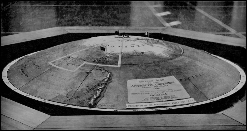
Relief model of Antarctica in old Parliament House Canberra on 1 August 1934.
Bayliss family image provided by Bruce Ryley.
Illuminated Address for English Cricket Team 1937
Over a six-month period in 1936-1937 Percival Bayliss spent some 400 hours carefully crafting an illuminated address. This framed work was presented by a representative of the Prime Minister (namely Thomas Walter White DFC MHR [1888-1957] who was Minister for Customs and was later knighted) to a visiting English cricket team in Canberra on 10 February 1937. The English team had commenced a two-day match against a country team that was hosted by the Federal Capital Territory Cricket Association. Afterwards the illuminated address was hung in the Pavilion at the Lord’s Cricket Ground in St John’s Wood, London.
The address was said to be: most artistic in conception, design and execution, and to reflect the greatest possible credit on Mr Bayliss. The address embodied the monograms of the Marylebone Cricket Club and the Federal Capital Territory Cricket Association, the Coat of Arms of Australia in a central position and those of the States arranged within the border of laurels.
Also included were the Coat of Arms of the City of London, the Canberra Coat of Arms and a drawing of the Federal Parliament House. The address was mounted on maple silkwood timber selected by the Lord Mayor of Sydney and framed with fiddleback blackwood selected by the Chairman of the Victorian Forestry Commission. A few of the many contemporary press reports on this matter are provided at Appendix E.
Initially, the illuminated address was displayed permanently in the Long Room of the Pavilion at Lord's Cricket Ground in London. However, it is now housed in the Marylebone Cricket Club Museum that is located behind the Long Room. Percival Bayliss’s grandson Dr Bruce Ryley and Diane Ryley, Bruce’s wife, took the opportunity to inspect his grandfather’s renowned work during a visit to Lord’s in May 2016; as shown in the image below.
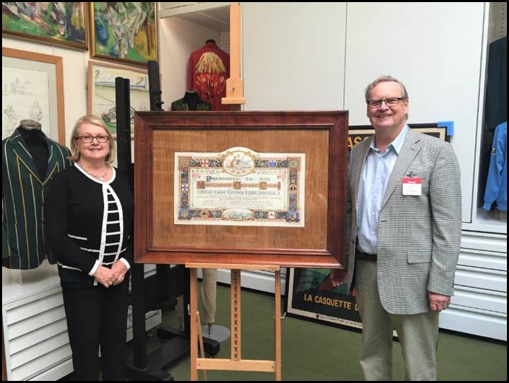
Diane and Bruce Ryley with the 1937 illuminated address at Lord’s in 2016.
Image provided by Bruce Ryley.
Pictorial Map of the Northern Territory 1938
During 1937, Percival Bayliss compiled and drew a Pictorial Map of the Northern Territory. It was launched in 1938 by John McEwen, Minister for the Interior. The map measured 10 feet by 6 feet and was part of the Northern Territory exhibit in the All Australian Exhibition and Trades Fair at the Sydney Royal Agricultural Show that ran for 13 days from 12 April 1938.
When launching the map Mr McEwen stated that its preparation had involved a considerable amount of research and arduous work on the part of Percival Bayliss. McEwen indicated that the map would be copied in reduced form and made available to schools.
In 1990, a facsimile reprint of a reduced (43 x 26 cm) version of the map was reproduced by the Northern Territory Department of Lands and Housing, Darwin. For a National Library of Australia Catalogue listing of the facsimile map and some of the contemporary press coverage that described the original 1938 Pictorial Map of the Northern Territory please refer to Appendix F.
Map of Antarctica at 1:10 Million scale 1939
The then Commonwealth Department of Works and Railways published a map of Antarctica in 1930 that had been compiled in 1929. However, owing to subsequent exploration activity in a land that was yet to be fully explored, the 1929 map soon became obsolete. In 1933 the then Department of the Interior’s Property and Survey Branch was tasked with revising the 1929 Antarctica map compilation.
A revised draft of the Antarctica map was first completed in June 1935. Following circulation of the draft map within Commonwealth Government agencies over the next few years many requests for amendments were received. It was clear that the 1935 revision was not meeting all necessary requirements. Also additional information from ongoing exploration activity was being received.
The image below is a copy of Edward Bayliss’s October 1935 working plot of the course of the Norwegian depot oil tanker Thorshavn (11 000 dead weight tons) in the Mount Caroline Mikkelsen Region, Ingrid Christensen Coast of Antarctica. The plot was taken from a chart in a report on Norwegian Discoveries in Antarctica in the Polar Record, Volume 2, Issue 10, of July 1935. This working plot was part of the Antarctica map preparation.
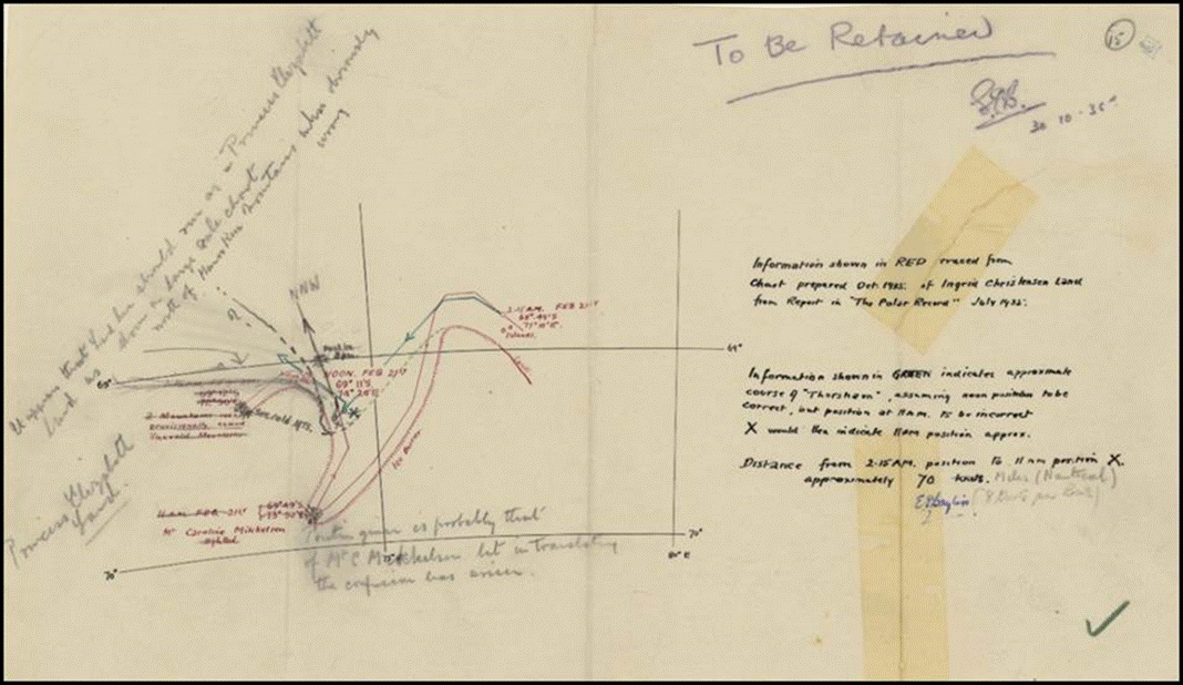
1935 working plot Mount Caroline Mikkelsen Region, Antarctica.
National Library of Australia image, Libraries Australia ID 57094059.
In early 1938, an intensive study of Antarctica commenced and considerable research was undertaken by John Stanley Cumpston (1909-1986), of the Department of External Affairs. Consequently Percival Bayliss compiled, drew and lithographed a new map of Antarctica at 1:10 Million scale that was printed in 1939. A copy of this map is provided below. Messrs Bayliss and Cumpston jointly prepared a Handbook and Index to accompany the map of Antarctica and this work can be accessed from the link at Bayliss and Cumpston in the references below.
Some brief biographical details on John Stanley Cumpston are provided in Appendix G.
Bayliss’s 1939 map of Antarctica was released to the general public early in 1940 together with the accompanying Handbook and Index. The map and handbook became recognised internationally as a very significant work. An in‑depth account of The 1939 Australian Map of Antarctica was given by Nat Mapper John Manning PSM LS, M Env Sc, MBA, PhD in an article published in The Globe No 65, in 2010. In this article Dr Manning noted: The map was a masterpiece of information gathering and careful presentation supplemented by the well‑prepared handbook, which listed names, gave details of claims and accepted boundaries of lands named by explorers, and a history of recent Antarctic expeditions.
There was also a two-sheet version of Bayliss’s 1939 map of Antarctica. This version was at a scale of 1:7.5 Million. The two-sheet version was also publicly available (Manning, 2010).
The 1939 Antarctica map and handbook were reviewed by British astronomer and geographer Arthur Robert Hinks (1873-1945) MA CBE FRGS FRS in an article published in The Geographical Journal, Volume 96, No 6, in December 1940. The text of Hinks’ review is provided in Appendix H.
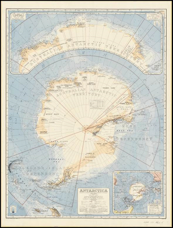
The EP Bayliss 1939 map of Antarctica at 1:10 Million scale.
Source: National Library of Australia call number: MAP G9800 1939.
A zoomable version of this map is available at this link.
Report on the Allied Geographical Section 1944
In 1944 Percival Bayliss prepared a report on the Allied Geographical Section and other Allied services organisations. The Allied Geographical Section reported to General Douglas MacArthur's General Headquarters, South West Pacific Area in Brisbane but appears to have at least some elements based in Victoria. An edited listing, from the National Library of Australia catalogue, of the material covered in the 1944 Bayliss report and in some of its numerous appendices is provided at Appendix I. Unfortunately, the National Library of Australia does not hold a complete set of the Bayliss report appendices.
From the National Library of Australia catalogue it appeared that the Bayliss report was completed in September 1944. The report followed from Percival’s visit to Melbourne and Bendigo and provided the results of his enquiries into various matters associated with the preparation and reproduction of maps and related matters. The report included sections on Land Headquarters Cartographic Company (based in Bendigo from June 1942), the Base Map Plant (operated by the United States 648th Engineer Topographic Battalion in the Melbourne CBD), Directorate of Survey (Melbourne), the Royal Australian Air Force Map Section, and the Department of Civil Aviation. Some further brief information on the 648th Battalion is provided in Appendix J.
By way of context, Service needs during World War II led to the production of comprehensive geographical handbooks covering areas to the north of Australia as well as the compilation of much geographical information about Australia itself. By early 1942 there was an urgent need for geographical information about New Guinea and the Solomon Islands. Following a directive from General Douglas MacArthur, the General Headquarters, South West Pacific Area ordered the establishing of an Allied Geographical Section on 19 July 1942 (Mellor, 1958).
The Allied Geographical Section developed into a fairly large organisation that included highly qualified people in geography and various other fields including, geology, meteorology, navigation services, airfield construction, anthropology, engineering, and Military Intelligence. By July 1943 the Section included 36 Australians and 3 Americans; by July 1944 there were 84 Australians and 15 Americans; and by July 1945 there were 117 Australians and 77 Americans (Mellor, 1958). The Section was dissolved on 30 November 1945. (In April 1943, one of the new attachments to the Allied Geographical Section as a Staff Captain [Intelligence Officer] was John Cumpston who had previously worked on A Handbook and Index to accompany a Map of Antarctica that Percival Bayliss compiled in 1939.)
The Allied Geographical Section published 110 terrain studies, 62 terrain handbooks, 101 special reports, and other works. The terrain studies were comprehensive geographies, some covering more than 150 pages of text as well as 30 or more maps and photographs. The terrain studies covered virtually the whole of the South West Pacific Area and much of Japan. Over 65 000 copies of the terrain studies were distributed by September 1945. Also some 114 000 copies of the separate terrain handbooks were distributed. The terrain handbooks were briefer but generally more up-to-date than the terrain studies. In addition, over 13 000 special report copies were distributed (Mellor, 1958; and Foott and Wojtkowski, 2015).
Another of the Section's achievements (with cooperation from 76 Australian libraries) was the production of a four-volume work: An Annotated Bibliography of the South West Pacific and Adjacent Areas (Mellor, 1958). Volumes in the Bibliography varied between 270 and 330 pages in length. The first three volumes appear to have been released in Brisbane in August 1944. The fourth volume was a supplement to the earlier volumes and was released in October 1945. Further information on the Annotated Bibliography is provided in Appendix K.
In 2005, a comprehensive review of the Allied Geographical Section was published by the Strategic and Defence Studies Centre at the Australian National University. This work was titled A Basis for Victory: the Allied Geographical Section 1942-1946 and was written by Ruben Bowd. In his foreword to this work General Peter Cosgrove AC MC, then Chief of the Australian Defence Force, noted that the Allied Geographical Section not only provided…a basis for victory against the Japanese. It also, along with other intelligence bodies, formed the basis for post-second world war intelligence agencies in Australia.
In 2012, Monash University Library initiated a project to digitise its extensive collection of Allied Geographical Section terrain studies and other material and make these publicly accessible; for more information see Foott and Wojtkowski (2015) in the references.
Conference on the National Survey and Mapping of Australia 1945
In January 1945, several additional Department of the Interior officers were among some 30 people who attended a major conference on the future direction and coordinating arrangements for Australia’s post-war topographic mapping and geodetic survey activities. This Conference on the National Survey and Mapping of Australia principally involved the then Commonwealth Survey Committee and State Surveyors-General.
The additional Department of the Interior officers attending the conference were Francis Leslie Hatfield, Edward Percival Bayliss, William James Sear and an AC Booth. At the time, Frank Hatfield was Chief Draftsman of the Department’s Drafting and Plan Printing Section in the Property and Survey Branch. Messrs Bayliss and Sear would later become the Chief Cartographer (in turn) of the organisation that would arise as an outcome of the conference.
The conference was held in the Senate committee rooms at Parliament House, Canberra during 15-19 January 1945. It was chaired by Frederick Marshall Johnston (1885-1963) as the Commonwealth Surveyor General and the conference secretary was John Noble Core Rogers (1898-1971).
Main recommendations arising from the 1945 conference included that a national approach to the mapping of Australia be adopted. This approach was to be coordinated by a newly created National Mapping Council. The new Council was to be chaired by the Commonwealth Surveyor General who would need to be assisted by a deputy.
Prime Minister John Curtin concurred with these recommendations and by March 1945, had obtained the agreement of the State Premiers to a coordinated national mapping program and the formation of a National Mapping Council. Curtin announced on Tuesday 6 March 1945 that there was full Cabinet approval for the establishment of a National Mapping Council (Campbell, 2008). Thus the remit for National Mapping was put in place. (John Curtin died in the early hours of 5 July 1945, at age 60 years.)
As part of the Commonwealth’s post-World War II national mapping initiatives that followed the 1945 Canberra conference, Commonwealth Surveyor General and Chief Property Officer, Frederick Johnston was given the additional roles of Director of National Mapping and Chairman of the National Mapping Council. On 21 March 1946, Bruce Philip Lambert (1912-1990) was appointed Deputy Director of National Mapping. Also in 1946, John Rogers was appointed Assistant Commonwealth Surveyor General.
On 29 March 1949, following Johnston's retirement the previous month, John Rogers was promoted to the positions of Commonwealth Surveyor General and Chief Commonwealth Property Officer as well as Director of National Mapping and Chairman of the National Mapping Council.
In March 1951, John Rogers was promoted to Assistant Secretary, Australian Capital Territory Planning and Development and also remained Commonwealth Surveyor General. Owing to Rogers’ significant additional responsibilities, he relinquished the roles of Director of National Mapping and Chairman of the National Mapping Council. These latter two positions were subsequently assumed by Bruce Lambert who held both positions until his retirement in 1977.
Chief Cartographer National Mapping Section 1947-1950
Staffing arrangements for the new National Mapping Section within the Property and Survey Branch of the Department of the Interior were initially put in place during 1947 and 1948. Percival Bayliss was promoted to the newly created position of Chief Cartographer, Third Division, in the Cartographic Sub‑section of the National Mapping Section.
This promotion was promulgated on page 1115 of the Commonwealth of Australia Gazette, Issue No 70, on 10 April 1947. The stated duties of this position were to organise, direct, supervise and edit the work of the Cartographic Sub-section.
The National Mapping Section was created in the Property and Survey Branch of the Department of the Interior at the Acton Offices in Lennox Crossing, Acton. The actual crossing over the Molonglo River was inundated in the early 1960s when Lake Burley Griffin was created. (The National Mapping Section’s Photogrammetric Survey Sub-section was created in Melbourne in 1947 and remained there in various organisational forms until December 1997.)
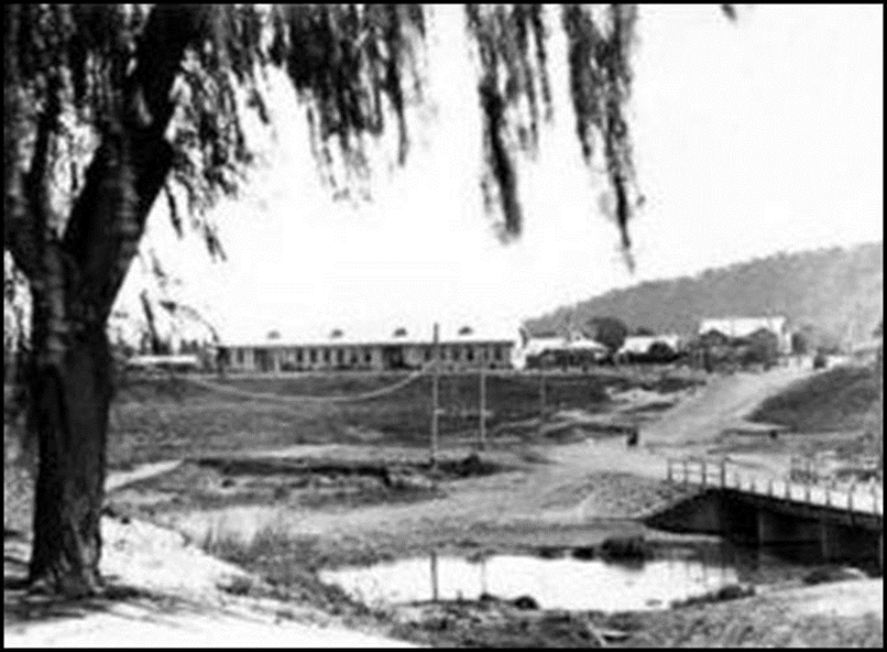
Acton Offices 1920s from Lennox Crossing bridge (1911) over the Molonglo River.
Image from Mildenhall Collection, National Archives of Australia: A3560, 2291.
Lines (1992) stated that the Drafting and Plan Printing Section in the Property and Survey Branch was the only identifiable group for inclusion in the new National Mapping Section. Prior to World War II, this Section undertook the compilation and drawing of the first 9 sheets in the Australian section of the 1:1 Million scale International Map of the World series.
The Section had also undertaken numerous other Commonwealth mapping tasks prior to and immediately after World War II, including:
· 1932 map of Town of Darwin, Hundred of Bagot, County of Palmerston, Northern Territory at 1:4 800 scale
· 1933 Canberra city map at 1:12 672 scale
· strip maps for aviation navigation purposes
· sheets in the 1:1 Million scale Australian Aeronautical Map series and the related New Guinea-Papua base compilations for aeronautical maps
· 1936 Northern Territory of Australia Pastoral Map at 1:1.9 Million scale (with subsequent revised editions)
· 1937 map of Australia at 1:5 Million scale
· 1938 Northern Territory Pictorial Map
· 1939 map of Antarctica at 1:10 Million scale
· 1940 map of the world with Sydney as the centre at 1:44 Million scale
· 1941 map of the world with Perth as the centre at 1:44 Million scale
· 1942 Australia magnetic declination base map, Australian Aeronautical Series at 1:5 Million scale with isogonic lines in half degrees
· 1947 map of Australia at 1: 13.4 Million scale showing distribution of anthrax 1946-1947
· Late 1940s base map materials for resources atlases.
The above listing was prepared from Lines (1992) and from entries for the Property and Survey Branch in the National Library of Australia catalogue. The listing is only an indication of the mapping tasks undertaken by the Property and Survey Branch and is not exhaustive.
The Drafting and Plan Printing Section provided some of the personnel for the early Nat Map Cartographic Section headed by Percival Bayliss as Chief Cartographer (Lines, 1992; page 126).
Nat Map retirement 1950
Edward Percival Bayliss retired from the position of Chief Cartographer within the National Mapping Section, Property and Survey Branch, Department of the Interior on 25 January 1950. He was 62 years of age. Notification of his retirement was promulgated in the Commonwealth of Australia Gazette, Issue No 10 of Thursday 16 February 1950 on page 392.
Following the retirement of Percival Bayliss, William James (Bill) Sear (1900‑1986) was promoted to the position of Chief Cartographer in the Cartographic Sub-section of the National Mapping Section on 16 March 1950. Bill Sear held the position of Chief Cartographer until his own retirement on 2 July 1965. By then the Chief Cartographer position was located in the Division of National Mapping within the Department of National Development.
Vale
Edward Percival Bayliss died at the Canberra Community Hospital on Thursday 3 October 1957; he was 70 years of age. Percival was survived by Lavinia, his wife of 44 years and by their daughter Doris. Although not mentioned in his death notice Percival Bayliss was also survived by his son-in-law Thomas Ryley and by grandsons John and Bruce.
The remains of Percival Bayliss were buried in the ex‑service people’s section of the Canberra Public Cemetery (now called Woden Cemetery). His grave index is H-EX-E-007. Percival’s burial took place on Saturday 5 October 1957. The funeral director was Messrs MH O’Rourke of Queanbeyan.
A recent image of the memorial headstone on Percival’s grave is provided below. The inscription reads: He is not dead but is sleeping until heaven’s morning light appears. The motif at the top of the memorial is the World War I badge of the Royal Engineers with the central letters G v R standing for George V Rex (or George the Fifth King); for further information on the Royal Engineers badge please refer to Appendix B.
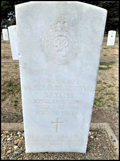
Headstone on Percival Bayliss’s grave in Woden Cemetery 2019.
Image supplied by Cathy Hales, Canberra Cemeteries Administration.
Lavinia Bayliss died in Brisbane in September 1964 at around 78 years of age. She was survived by her daughter Doris (Mrs Ryley), son-in-law Thomas and grandsons John and Bruce. Lavinia’s funeral service was held on 15 September 1964 at St Phillip's Church of England in Cornwall Street Annerley (Thompson Estate). Afterwards her remains were conveyed to the Mt Thompson Crematorium in Holland Park. Lavinia’s funeral arrangements were conducted by Messrs KM Smith Funeral Directors.
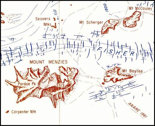
Mount Bayliss Antarctica
Following his death, a geographical feature in Antarctica was named for Percival Bayliss. Mount Bayliss is located at 73° 26' South Latitude and 62° 40' East Longitude; about 700 kilometres south of Mawson Base. It is a fairly low, rock outcrop elongated east west and about 17 kilometres east of Mount Menzies in Mac Robertson Land.
The feature was discovered from an Australian National Antarctic Research Expeditions aircraft during 1957. The feature was named after EP Bayliss as the cartographer who prepared the map of Antarctica that was published in 1939 by the Property and Survey Branch of the Department of Interior, Canberra. Mount Bayliss and the surrounding area is depicted in the images below.
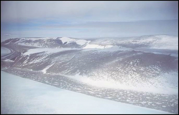
Mount Bayliss Mac Robertson Land Antarctica in 1995.
Image by Mathew Godbold, Australian Antarctic Data Centre catalogue ID 2783B5.
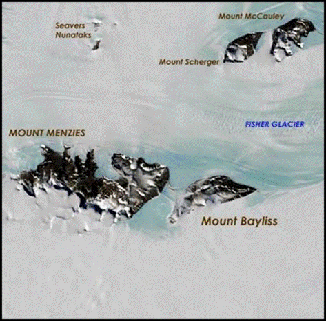
Mount Bayliss area in Mac Robertson Land Antarctica.
United States Geological Survey satellite image from Google Earth.
2019 Collectable Stamp showing Mount Bayliss
The above image of the Mount Bayliss area was depicted on a collectable $2 stamp: Division of National Mapping, 1971 Australian Antarctic Territory. This stamp was part of a Mapping the Australian Antarctic Territory collectable series issued by Australia Post on 20 August 2019.
The Mount Bayliss area depicted on the stamp was taken from the 1:500 000 scale map sheet SS40‑42 Mawson-Southern Prince Charles Mountains Part 2 that was produced by the Division of National Mapping in November 1971. The relevant section of this map is provided in the image below.
Section from 1: 500 000 scale Mawson-Southern Prince Charles Mountains Part 2 map sheet produced by the Division of National Mapping in November 1971.
Acknowledgements
During the research for and the preparing of this article the following people generously provided assistance:
· Michelle Dariol, Canberra Cemeteries Administration
· John Manning PSM, former Nat Map senior surveyor, supervising surveyor and assistant director
· Cathy Hales, Canberra Cemeteries Administration
· Ursula Harris, Mapping and Spatial Data Manager, Australian Antarctic Data Centre, Australian Antarctic Division, Department of the Environment and Energy
· Syd Kirkby AO MBE, former Nat Map senior surveyor, supervising surveyor and assistant director
· Kaye Nardella, senior curator of the Museum of Lands, Mapping and Surveying, Brisbane
· David Sisson, owner and operator of the Australian Mountains website
· Jody White, Collections Manager, Eden Killer Whale Museum
· Paul Wise OAM, founder, operator, and editor-in-chief of the XNatmap website
· Karen McLean, daughter of the author, proof-read early drafts.
· Susan Tospell, sister of the author, proof-read a late draft and also discovered the Bayliss family images.
· Dr Bruce Ryley, grandson of Percival Bayliss, kindly provided additional information and images after reading this article on the XNatmap website. Bruce’s material was the basis of the November 2020 update.
The author gratefully acknowledges the kind assistance provided by these people.
References
Allied Geographical Section, South West Pacific Area (1944), An Annotated Bibliography of the Southwest Pacific and Adjacent Areas, in 4 Volumes:
Volume 1 (332 pages): The Netherlands and British East Indies and the Philippine Islands, 8 August 1944
Volume 2 (290 pages): The Mandated Territory of New Guinea, Papua, the British Solomon Islands, the New Hebrides and Micronesia, 8 August 1944 Volume 3 (270 pages): Malaya, Thailand, Indo China, the China Coast and the Empire of Japan. Released by General Headquarters, Allied Forces, South West Pacific Area.
Volumes 1-3 Released Allied Geographical Section, Brisbane, August 1944.
Volume 4: Supplement to Volumes 1-3, October 1945 (reprinted 1990).
Digital copies of Volumes 1-3 were accessed from the United States National Library of Medicine section of the United States Department of Health and Human Services website at: https://collections.nlm.nih.gov/catalog/nlm:nlmuid-58530310RX1-mvpart
Anonymous (undated), A Short History of the Department of the Interior, an Archives ACT Research Guide; accessed from the Australian Capital Territory Archives section of the Australian Capital Territory Government website at: https://www.archives.act.gov.au/__data/assets/pdf_file/0007/562561/Dept_Interior_History.pdf
Anonymous (undated A), Searches for Bayliss and related family members on United Kingdom Outbound Passenger Lists 1890-1960; accessed from the Ancestry website at: http://search.ancestry.com.au/search/
Anonymous (undated B), Search for Bayliss grave details at Woden Cemetery (Allotment Index H-EX-E-007), accessed from the Grave Search function on the Canberra Cemeteries website at: http://www.canberracemeteries.com.au/grave-search
Anonymous (various dates), Various Death Notice Searches, on the Ryerson Index to death notices and obituaries in Australian newspapers; accessed at: http://ryersonindex.org/search.php
Anonymous (1919), Returned Soldiers Arrival of Ormonde, an article in The Age, Saturday 27 December 1919, page 7; accessed from the National Library of Australia’s Trove search service on the National Library of Australia website at: https://trove.nla.gov.au/newspaper/article/203700119
Anonymous (1924), Nearly 600 Migrants Due Next Week, a migration article in The West Australian, Saturday 5 January 1924, page 12; accessed from the National Library of Australia’s Trove search service on the National Library of Australia website at: https://trove.nla.gov.au/newspaper/article/31208529?
Anonymous (1924 A), New Arrivals: 405 Arrive on Saturday, an article in The Argus, Monday 21 January 1924, page 6; accessed from the National Library of Australia’s Trove search service on the National Library of Australia website at: https://trove.nla.gov.au/newspaper/article/1921440
Anonymous (1929), Round the Departments-Works, a report in The Canberra Times, Saturday 12 October 1929, page 5; accessed from the National Library of Australia’s Trove search service on the National Library of Australia website at: https://trove.nla.gov.au/newspaper/article/1016180
Anonymous (1930), Round the Departments, an item in The Canberra Times, Saturday 12 July 1930, page 2; accessed from the National Library of Australia’s Trove search service on the National Library of Australia website at: https://trove.nla.gov.au/newspaper/article/2315087
Anonymous (1932), North Canberra Diggers’ sub-branch to have new name, an article in The Canberra Times, Friday 22 January 1932, page 4, accessed from the National Library of Australia’s Trove search service on the National Library of Australia website at: https://trove.nla.gov.au/newspaper/article/2264227
Anonymous (1932A), Distress Fund 104 Diggers get Helping Hand, an article in The Canberra Times, Tuesday 26 July 1932, page 3; accessed from the National Library of Australia’s Trove search service on the National Library of Australia website at: https://trove.nla.gov.au/newspaper/article/2293341
Anonymous (1933), Soldiers’ Congress: Federal Capital Territory Branches prepare big year for Canberra three gatherings in view, an article in The Canberra Times, Monday 20 February 1933, page 2; accessed from the National Library of Australia’s Trove search service on the National Library of Australia website at: https://trove.nla.gov.au/newspaper/article/2338535
Anonymous (1935), Diggers All: Imperial Men in Returned Soldiers League, an article in The Canberra Times, Thursday 7 March 1935, page 2; accessed from the National Library of Australia’s Trove search service on the National Library of Australia website at: https://trove.nla.gov.au/newspaper/article/2386805
Anonymous (1938), Pictorial Map of Northern Territory, an article in The Central Queensland Herald (Rockhampton), Thursday 28 April 1938, page 58; accessed from the National Library of Australia’s Trove search service on the National Library of Australia website at: https://trove.nla.gov.au/newspaper/article/70579016
Anonymous (1938 A), Death Notice: Bayliss, Albert Edward, a Family Notice in The Argus, Monday 1 August 1938, page 8; accessed from the National Library of Australia’s Trove search service on the National Library of Australia website at: https://trove.nla.gov.au/newspaper/article/12454566
Anonymous (1941), AIF to Ski on Slopes of Lebanon, an article in The Argus, Tuesday 28 October 1941, page 5; accessed from the National Library of Australia’s Trove search service on the National Library of Australia website at: https://trove.nla.gov.au/newspaper/page/617526
Anonymous (1940), Weddings: Ryley-Bayliss, an article in The Canberra Times, Wednesday 21 August 1940, page 3; accessed from the National Library of Australia’s Trove search service on the National Library of Australia website at: https://trove.nla.gov.au/newspaper/article/2536061
Anonymous (1942), Joined the AIF, an item in The Dalby Herald, Friday 13 March 1942, page 2; accessed from the National Library of Australia’s Trove search service on the National Library of Australia website at: https://trove.nla.gov.au/newspaper/article/216400752
Anonymous (1942 A), Death Notice: Bayliss, Adelaide Sarah, a Family Notice in The Age, Monday 21 September 1942, page 5; accessed from the National Library of Australia’s Trove search service on the National Library of Australia website at: https://trove.nla.gov.au/newspaper/article/206825366
Anonymous (1949), Timber Commission in Warwick, an item in the Warwick Daily News, Wednesday 7 September 1949, page 2; accessed from the National Library of Australia’s Trove search service on the National Library of Australia website at: https://trove.nla.gov.au/newspaper/article/187175236
Anonymous (1957), Death Notice: Bayliss, Edward Percival, a Family Notice in The Canberra Times, Saturday 5 October 1957, page 8; accessed from the National Library of Australia’s Trove search service on the National Library of Australia website at: https://trove.nla.gov.au/newspaper/article/91239165
Anonymous (1964), Lavinia Blanche Bayliss, Funeral Notice in The Canberra Times, Tuesday 15 September 1964, page 13; accessed from the National Library of Australia’s Trove search service on the National Library of Australia website at: https://trove.nla.gov.au/newspaper/article/131748795
Anonymous (2010), Johnnie Abbottsmith: a mountain legend, an article in the Perisher Historical Society Newsletter, Issue 5 Summer 2010-11, pages 4-5; accessed from the Perisher Historical Society website at: http://www.perisherhistoricalsociety.org.au/attachments/033_PHS%20Newsletter%20-%20Issue%205%20-%20Summer%202010-2011.pdf
ArchivesACT (undated), Government Tenancy Registers – Reid, Section 23 Block 5: 34 Coranderrk Street; accessed from Australian Capital Territory Archives, Government Tenancy Registers section of the Australian Capital Territory Government website at: https://www.archives.act.gov.au/__data/assets/pdf_file/0004/802867/Coranderrk-St-34-Reid-S23-B5-2012-03916.pdf
Australia Post (2019), Mapping the Australian Antarctic Territory, a new collectable stamp series issued on 20 August 2019, on the Collectables section of the Australia Post website; accessed at: https://australiapostcollectables.com.au/stamp-issues/mapping-the-aat
Australian Antarctic Division (1973), Mount Bayliss, a place name (Id 1452) in the Australian Antarctic Gazetteer, Australian Antarctic Data Centre, Department of the Environment and Energy; accessed at: https://data.aad.gov.au/aadc/gaz/display_name.cfm?gaz_id=1452
Australian Electoral Commission (1903-1980), Searches of various historical electoral rolls; accessed from the Ancestry website at: http://search.ancestry.com.au/search/
Australian Military Forces (1941-1942), Unit Diary, 9th Australian Division Ski Company December 1941-February 1942, in Australian Military Forces, Army Headquarters, formations and unit diaries 1939-1945, East and Middle East Units, Accession No RCDIG1019787, Collection No AWM52 1/12/14/1; accessed from Australian War Memorial website at: https://www.awm.gov.au/collection/C1360670
Australian Military Forces (1942), 9th Australian Division Ski Company February 1942 Appendices, in Australian Military Forces, Army Headquarters, formations and unit diaries 1939-1945, East and Middle East Units, Accession No RCDIG1019731, Collection No AWM52 1/12/14/2; accessed from Australian War Memorial website at: https://www.awm.gov.au/collection/C1360614
Australian War Memorial (undated), Ski Jacket: Major RW Savage, Australian Corps Ski School, Syria, an item listing in the Australian War Memorial Collection section, Accession Number: RELAWM31302.001; accessed from the Australian War Memorial website at: https://www.awm.gov.au/collection/C147723
Ayers, Philip James (1999), Mawson: A Life, Melbourne University Press, Carlton South, 2003 paperback edition, ISBN 0522 85078 2; accessed from Google Books at: https://books.google.com.au/books/about/Mawson.html?id=n1RKOD_ld10C&redir_esc=y
Batt, Garry (1912), Mirboo North Cemetery, a listing on the Australian Cemeteries website; accessed at: http://www.australiancemeteries.com.au/vic/sthgippsland/mirboo_data.htm
Bayliss, Edward Percival (undated), Edward Percival Bayliss 264479 Royal Engineers, a summary of British Army and Australian ex-service organisations service; copy of typed manuscript provided by Dr Bruce Ryley, 24 June 2020.
Bayliss, Edward Percival (1935), Mount Caroline Mikkelsen Region, Ingrid Christensen Coast, Antarctica, a sketch map held in the National Library of Australia; accessed from the National Library of Australia’s Trove search service on the National Library of Australia website at: https://trove.nla.gov.au/work/203849863
Bayliss, Edward Percival (1937), Pictorial map of the Northern Territory for Australia's 150th Anniversary celebration 1938, facsimile reproduced by Northern Territory Department of Lands and Housing, Darwin in 1990 at a scale of 1:678 000 from the original compiled and drawn by Edward Percival Bayliss FRGS 1937 and published in Canberra by the Property and Survey Branch of the Department of the Interior in 1938. A National Library of Australia catalogue listing only; accessed from the National Library of Australia’s Trove search service on the National Library of Australia website at: https://trove.nla.gov.au/work/229066819
Bayliss, Edward Percival (1939), Antarctica 1: 10 million scale map, compiled, drawn and lithographed by EP Bayliss and produced by the Property and Survey Branch of the Department of the Interior, Canberra; accessed from the National Library of Australia’s Trove search service on the National Library of Australia website at: http://nla.gov.au/nla.obj-236895938/view
Bayliss, Edward Percival and Cumpston, John Stanley (1939), Handbook and Index to accompany a Map of Antarctica, Department of External Affairs, LF Johnston Government Printer, Canberra, accessed from XNatmap website at: http://www.xnatmap.org/daat/docs/manningj/Bay%20n%20Cump%201939.pdf
Bayliss, Edward Percival and others (1944), Land Head Quarters (Aust) Cartographic Company, 648th Engineer Topo Battn (US Army) and other organisations: a report by EP Bayliss FRGS, September 1944, a National Library of Australia catalogue listing only; accessed from the National Library of Australia’s Trove search service on the National Library of Australia website at: https://trove.nla.gov.au/work/31412107?q&versionId=38095234
Bayliss, Edward Percival (1944 A), Appendices to report on the Allied Geographical Section and other Allied services organisations, General Head Quarters, South West Pacific Area, a National Library of Australia catalogue listing only; accessed from the National Library of Australia’s Trove search service on the National Library of Australia website at: https://trove.nla.gov.au/work/31412102?q&versionId=38095229
Bowd, Reuben R E (2005), A basis for victory : the Allied Geographical Section 1942-1946, Canberra Papers on Strategy and Defence No 157, Strategic and Defence Studies Centre, Australian National University, Canberra 2005, ISBN 0731554558; accessed from the Australian National University website at: http://bellschool.anu.edu.au/sites/default/files/publications/attachments/2016-03/157_A_Basis_for_Victory__The_Allied_Geographical_Section_1942-1946__168p_0731554558_0.pdf
Bowden, Timothy Gibson (2011), Heard Island: The Climbing of Big Ben, an article in Aurora, Volume 30, No 3, pages 6-12, March 2011, Journal of the Australian National Antarctic Research Expeditions Club; accessed from Tim Bowden website at: https://www.timbowden.com.au/wp-content/uploads/2012/02/bigben.pdf
Campbell, Heather (2008), Tuesday 6 March 1945 in 1945 Prime Minister from Diary of a Labor Man 1917-1945, published by John Curtin Prime Ministerial Library; accessed from the Curtin University website at: http://john.curtin.edu.au/diary/primeminister/1945.html
Commonwealth of Australia (1928), Appointment on Probation of Edward Percival Bayliss to the position of Draftsman, Division III, Lands and Surveys Branch, Central, Department of Works and Railways (with effect from 3 January 1928*), promulgated in the Commonwealth of Australia Gazette, Issue 22, Thursday 1 March 1928, page 441; accessed from the National Library of Australia’s Trove search service on the National Library of Australia website at: https://trove.nla.gov.au/newspaper/article/232528377/25016007
*Date of appointment amended to 20 December 1927 in Commonwealth of Australia Gazette, Issue 45, Thursday 10 May 1928, page 935; see: https://trove.nla.gov.au/newspaper/article/232528899
Commonwealth of Australia (1936), Promotion of Edward Percival Bayliss to the newly created position of Draftsman, Grade 2, Third Division in the Property and Survey Branch of the Department of the Interior, promulgated in the Commonwealth of Australia Gazette, Issue No 59, Thursday 23 July 1936, page 1355; accessed from the National Library of Australia’s Trove search service on the National Library of Australia website at: https://trove.nla.gov.au/newspaper/article/232666604/25043787
Commonwealth of Australia (1938), Promotion of Edward Percival Bayliss to the newly created position of Cartographer, Third Division, Drafting Section, Property and Survey Branch of the Department of the Interior, promulgated in the Commonwealth of Australia Gazette, Issue No 52, Thursday 1 September 1938, page 2161; accessed from the National Library of Australia’s Trove search service on the National Library of Australia website at: https://trove.nla.gov.au/newspaper/article/232654464
Commonwealth of Australia (1947), Promotion of Edward Percival Bayliss to the newly created position of Chief Cartographer, Third Division, Cartographic Sub-section, National Mapping Section of the Property and Survey Branch in the Department of the Interior, promulgated in the Commonwealth of Australia Gazette, Issue No 70, Thursday 10 April 1947, page 1115; accessed from the National Library of Australia’s Trove search service on the National Library of Australia website at: https://trove.nla.gov.au/newspaper/article/232789191/25114733
Commonwealth of Australia (1950), Retirement of Edward Percival Bayliss, Chief Cartographer, Department of the Interior Australian Capital Territory as from close of business on 25 January 1950, promulgated in the Commonwealth of Australia Gazette, Issue No 10, Thursday 16 February 1950, page 392; accessed from the National Library of Australia’s Trove search service on the National Library of Australia website at: https://trove.nla.gov.au/newspaper/article/232881903/25106121
Croft, Julian (2000), Norway, Nevil Shute (1899–1960), an entry in the Australian Dictionary of Biography, National Centre of Biography, Australian National University, accessed from the Australian National University website at: http://adb.anu.edu.au/biography/norway-nevil-shute-11262/text20089
Cox, Anthony David Marchell, (1992-93), The Lebanon: Some Memories of Mountain Warfare Training during World War II, an article in The Alpine Journal, Volume 97, 1992-93, Number 341, pages 191-197, journal of The Alpine Ski Club (UK), accessed from the Alpine Ski Club website at: https://www.alpinejournal.org.uk/Contents/Contents_1992-93_files/AJ%201992%20191-197%20Cox%20Lebanon.pdf
Dariol, Michelle (2019), Personal communications.
Department of Veterans’ Affairs (undated), Brighton, John, Service Number: V145850, World War II Nominal Roll listing; accessed from the Department of Veterans’ Affairs website at: http://nominal-rolls.dva.gov.au/veteran?id=585940&c=WW2
Department of Veterans’ Affairs (undated B), Ryley, Thomas Frederick, Service Number: Q128697, World War II Nominal Roll listing; accessed from the Department of Veterans’ Affairs website at: http://nominal-rolls.dva.gov.au/veteran?id=83288&c=WW2#R
Dod, Karl Christian (1965), 648th Engineer Topographic Battalion, on page 190 in The Corps of Engineers: The War against Japan; United States Army in World War II: The Technical Series, released by the Office of the Chief Military Historian, United States Army, Washington DC, 1966; accessed from google books website at: https://books.google,com.au
Dunstan, David (2007), Evans, Sir Bernard (1905–1981), an entry in the Australian Dictionary of Biography, National Centre of Biography, Australian National University, accessed from the Australian National University website at: http://adb.anu.edu.au/biography/evans-sir-bernard-12465/text22419
Fitzgerald, Lawrence (1980), US Mapping Units, page 57 in Lebanon to Labuan: A Story of Mapping by the Australian Survey Corps World War II (1939-1945); published by JG Holmes Pty Ltd, Melbourne, 124 pages, ISBN 0959497900 (corrected).
Foott, Bronwyn and Wojtkowski, Barbara (2015), Preserving History: Digitisation of Allied Geographical Section, South-West Pacific Area, Terrain Study collection; a powerpoint presentation; accessed from Mapping Sciences Institute, Australia website at: http://mappingsciences.org.au/wp-content/uploads/2015/06/BrowynFoottBarbaraWojtkowski-PerservingHistory.pdf
Frizell, Helen (1947), Former Alps Ranger will go to Antarctica, an article in The Australian Women's Weekly, Saturday 27 September 1947, page 13;
accessed from the National Library of Australia’s Trove search service on the National Library of Australia website at: https://trove.nla.gov.au/newspaper/article/46944405
Fuchs, Vivian Ernest and Hillary, Edmund Percival (1958), The Crossing of Antarctica: The Commonwealth Trans-Antarctic Expedition 1955-58; Cassell and Company Limited, London.
General Register Office (various dates), Searches for Bayliss and related family members’ birth records on England and Wales Civil Birth Registration Index; accessed from the Ancestry website at: http://search.ancestry.com.au/search/
Goossens, Reuben (undated), Orient Steam Navigation Company Co Ltd RMS Ormonde 1957 to 1952, an article on the ssMaritime website; accessed at: https://ssmaritime.com/RMS-Ormonde.htm
Gough, David (2018), Early Forestry and 100 years of Timber Research in Queensland, pages 3-10 in Newsletter No 75, June 2018, Australian Forest History Society; accessed from Australian Forest History Society Inc website at: https://www.foresthistory.org.au/newsletter/afhsnewsletter75.pdf
Hales, Cathy (2019), Personal communications.
Harris, Ursula (2019), Personal communications.
Henderson, Peter Graham Faithfull (2007), Cumpston, John Stanley (1909‑1986), an entry in the Australian Dictionary of Biography, National Centre of Biography, Australian National University; accessed from the Australian National University website at: http://adb.anu.edu.au/biography/cumpston-john-stanley-12381/text22251
Hinks, Arthur Robert (1940), A New Map of Antarctica, a review in The Geographical Journal, Volume 96, No 6, December 1940, pages 435-438; published by The Royal Geographical Society, London.
His Majesty’ Government (1914), A State of War, a proclamation in the Supplement to The London Gazette, Issue 28861, Tuesday 4 August 1914, His Majesty's Stationery Office, 5 August 1914; accessed at: https://www.thegazette.co.uk/London/issue/28861/
Jefferys, Alan (2014) Indian Army Training for the Italian Campaign and Lessons Learnt, Chapter 6 (pages 103-119); in Hargreaves, Andrew L; Rose, Patrick J; and Ford, Matthew C (editors) (2014), Allied Fighting Effectiveness in North Africa and Italy, 1942-1945, History of Warfare series, Volume: 99; Brill (publisher), Leiden, The Netherlands; ISBN: 978-90-04-25570-8
Kirkby, Sydney Lorrimar (2019), Personal communications.
Langfield, Michele (1999), More People Imperative Immigration to Australia, 1901–39, National Archives of Australia Research Guides; accessed from the National Archives Australia website at: http://guides.naa.gov.au/more-people-imperative/chapter1/index.aspx
Lines, John Dunstan (1992), Australia on Paper: The Story of Australian Mapping, Fortune Publications, Box Hill, Victoria, ISBN 0646097695
Ling, Ted (2011), Commonwealth Government Records about the Northern Territory, National Archives Australia Research Guide; accessed from the National Archives Australia website at: http://guides.naa.gov.au/content/20122018-Guide022_tcm48-58753_tcm48-58753.pdf
Manning, John (2010) The 1939 Australian Map of Antarctica, a paper published in The Globe No 65, pages 19-27, Journal of the Australian and New Zealand Map Society, ISSN 0311-3930. The paper is also available from the Mapping Sciences Institute, Australia website at: http://www.mappingsciences.org.au/joom/images/heritage/THE_1939_AUSTRALIAN_MAP_OF_ANTARCTICA4.pdf
Manning, John (2019), Personal communications.
McCarthy, John (1996), The Story of Adastra: Its Aerial Survey and Mapping Activities; an item on the Adastra Aerial Surveys website; accessed at: http://www.adastron.com/adastra/company/mccarthy.htm
McLean, Lawrence William (2012), Frederick Marshall Johnston (1885-1963): A Biographical Sketch of Australia’s First Director of National Mapping, an article on the XNatmap website; accessed at: http://www.xnatmap.org/adnm/people/fmj/FMJ.htm
McLean, Lawrence William (2013), John Dunstan Lines 1920 – 2001: A Biographical Sketch of a Nat Map Stalwart; an article on the XNatmap website; accessed at: http://www.xnatmap.org/adnm/people/aabout/jdl.htm
McLean, Lawrence William (2013A), RAAF Supermarine Walrus 11 HD874 Snow Goose: The Heard Island Walrus, an article on the XNatmap website; accessed at: http://www.xnatmap.org/viat/docs/various/Walrus%20HI.htm
McLean, Lawrence William (2016), John Rogers ISO (1898-1971) Commonwealth Surveyor General, Director of National Mapping, and Chairman of the National Mapping Council, an article on the XNatmap website; accessed at: http://www.xnatmap.org/adnm/people/aabout/jncrogers.htm
McLean, Lawrence William (2017), Bill Sear (1900-1986) National Mapping Chief Cartographer 1950-1965, an article on the XNatmap website; accessed at: http://www.xnatmap.org/adnm/people/aabout/WJSear.htm
Mellor, David Paver (1958), Mapping and Charting the Continent, a section in Chapter 23-Camouflage, Civil Defence and Mapping, in Australia in the War of 1939–1945, Series 4 – Civil; Volume V – The Role of Science and Industry (1st Edition, 1958); accessed from the Second World War Official Histories section of the Australian War Memorial website at: https://s3-ap-southeast-2.amazonaws.com/awm-media/collection/RCDIG1070370/document/5519658.PDF
Milledge, Jim Sibree (2010), The Silver Hut Expedition 1960-1961, an article in High Altitude Medicine and Biology, Volume 11, Number 2, pages 93-101; the official Journal of the International Society for Mountain Medicine. Abstract accessed from the Pub Med database on the United States National Library of Medicine, National Institutes of Health website at: https://www.ncbi.nlm.nih.gov/pubmed/20586593
Millett, John David (1953), The Organization and Role of the Army Service Forces, Center of Military History United States Army, Washington DC (1987), Library of Congress Catalog Card Number: 53-61716; accessed at: https://history.army.mil/html/books/003/3-1/CMH_Pub_3-1.pdf
Murray, Pembroke Lathrop (1911), Official records of the Australian military contingents to the war in South Africa, 1899-1902, Albert J Mullett Government Printer Melbourne; accessed from the Australian War Memorial website at: https://www.awm.gov.au/collection/C1416414
Nailer, Christopher (undated), Williams, Hylton Ernest (1898–1968), an entry in People Australia, National Centre of Biography, Australian National University; accessed from the Australian National University website at: http://peopleaustralia.anu.edu.au/biography/williams-hylton-ernest-22182/text32065
Nardella, Kaye (2019), Personal communications.
National Archives of Australia (undated), Brighton, John Service Number 155; Citation: NAA: B2455, Brighton J; Item barcode: 4039210, accessed from search of First Australian Imperial Force personnel dossiers (World War I service records) on National Archives of Australia website at: http://www.naa.gov.au/collection/explore/defence/service-records/
National Archives of Australia (undated), Cumpston, John Stanley, Service Number NX70393; Citation: NAA: B883, NX70393, Item barcode: 4615664, accessed from search of Second Australian Imperial Force personnel dossiers (World War II service records) on National Archives of Australia website at: http://www.naa.gov.au/collection/explore/defence/service-records/army-wwii.aspx
National Library of Australia (various dates), Searches on Property and Survey Branch in the National Library of Australia catalogue; from the National Library of Australia website at: https://catalogue.nla.gov.au/
Pugh, Lewis Griffith Cresswell Evans (various dates), Private Papers of Captain LGCE Pugh, (listing only), in the Imperial War Museums, England; accessed from the Imperial War Museums website at: https://www.iwm.org.uk/collections/item/object/1030022113
Pugh, Lewis Griffith Cresswell Evans (1962), Himalayan Scientific and Mountaineering Expedition, 1960-61: The Scientific Programme, an article in The Geographical Journal, Volume 128, No 4, December 1962, pages 447-456; published by The Royal Geographical Society, London.
Pugh, Simon Francis (undated), Mountain Warfare Training Centre, a section of Simon's Family History website; accessed at: http://www.mrzsp.demon.co.uk/mwtc/index.htm
Pugsley, Christopher (undated), Review of the 2018 edition of James Riddell’s 1957 book Dog in the Snow: The Story of the Wartime Middle East Ski School; on JD Publishing website, accessed at: http://www.jdpublishing.co.nz/dog-in-the-snow.html
Read, Fergus (2018), British First World War Service Medals, an article on the Imperial War Museums website, accessed at: https://www.iwm.org.uk/history/first-world-war-service-medals
Rodgers, John Noble Core (Secretary) (1945), Conference on National Survey and Mapping of Australia, Commonwealth Survey Committee and State Surveyors-General, held at Parliament House, Canberra during 15-19 January 1945; unpublished meeting record by the Department of the Interior, Canberra; accessed from XNatmap website at: http://xnatmap.org/adnm/docs/1912/CSCSSG.htm
Royal Household at Buckingham Palace (undated), The Order of the Garter, a section on the official website of the British Royal Family; accessed at: https://www.royal.uk/order-garter
Ryley, Bruce Gordon (2020), Personal communications.
Sisson, David (2019), Personal communications.
Southern Metropolitan Cemeteries Trust (various dates), Searches for Alfred Edward Bayliss and Adelaide Sarah Bayliss grave details, in Springvale Botanical Cemetery, from Deceased Search on the Southern Metropolitan Cemeteries Trust website at: https://smct.org.au/deceased-search
Spencer Jones, Harold and Fleure, Herbert John (1948), Arthur Robert Hinks (1873-1945), an article in Obituary Notices of Fellows of the Royal Society, Volume 5, Issue 16, pages 716-732, 31 May 1948, Royal Society, London; accessed from the Royal Society Publishing website at: https://royalsocietypublishing.org/doi/pdf/10.1098/rsbm.1948.0008
State Library of New South Wales (undated), Colonel R W Savage - Collection of Slides, a listing on the Manuscripts, Oral History and Pictures Catalogue; accessed from the State Library of New South Wales website at: http://archival.sl.nsw.gov.au/Details/archive/110313564
Tospell, Susan (2019), Personal communications.
Ward, Michael (1990-91), Griffith Pugh: An 80th Birthday Tribute, an article in The Alpine Journal, Volume 95, Number 339, 1990-91, pages 188-190; journal of The Alpine Ski Club (UK), accessed from the Alpine Ski Club website at: https://www.alpinejournal.org.uk/Contents/Contents_1990-91_files/AJ%201990%20188-190%20Ward%20Pugh.pdf
Ward, Michael (1993), The first ascent of Mount Everest, an article in BMJ (formerly the British Medical Journal), Volume 306, Issue 6890, 29 May 1993, pages 1455-1458; BMJ Publishing Group Ltd, London; accessed at: https://www.bmj.com/content/bmj/306/6890/1455.full.pdf
Ward, Michael (1995), Lewis Griffith Cresswell Evans Pugh 1909-1994, an obituary in The Alpine Journal, Volume 100, Issue 344, pages 326-327; journal of The Alpine Ski Club (UK), accessed from the Alpine Ski Club website at: https://www.alpinejournal.org.uk/Contents/Contents_1995_files/AJ%201995%20325-345%20In%20Memoriam.pdf
White, Jody (2017), All aboard the Rag Tag Fleet with John, an article on John Abbottsmith in Sounding, newsletter of the Eden Killer Whale Museum, Volume 10, Issue 3, page 1, July 2017; accessed from the Eden Killer Whale Museum website at: http://killerwhalemuseum.com.au/wp-content/uploads/2017/08/Soundings-July-2017.pdf
White, Jody (2019), Personal communication.
Wise, Paul Joseph (2019), Personal communications.
List of Appendices
|
Appendix |
Title |
|
Elementary Drawing Certificate, the Science and Art Department, South Kensington and Sir William Abney |
|
|
World War I Service Medals and Royal Engineers Badge |
|
|
Bayliss Family Immigration Vessels 1919-1924 |
|
|
Other Bayliss family members in Australia 1919-2005 |
|
|
Illuminated Address for the English Cricket Team 1937 |
|
|
Pictorial Map of the Northern Territory 1938 |
|
|
John Stanley Cumpston (1909-1986) |
|
|
Review of Map of Antarctica at 1:10 Million scale 1939 |
|
|
Land Head Quarters (Aust) Cartographic Company, 648th Engineer Topo Battn (US Army) and other organisations: report by EP Bayliss FRGS. Published Australia, 1944 |
|
|
United States 648th Engineer Topographic Battalion |
|
|
An Annotated Bibliography of the Southwest Pacific and Adjacent Areas by the Allied Geographical Section, South West Pacific Area, 1944-45 |
|
|
1st Australian Corps Ski School and 9th Australian Division Ski Company 1941-42 |
|
|
About John Abbottsmith (1918-1989) |
Elementary Drawing Certificate, the Science and Art Department, South Kensington and Sir William Abney
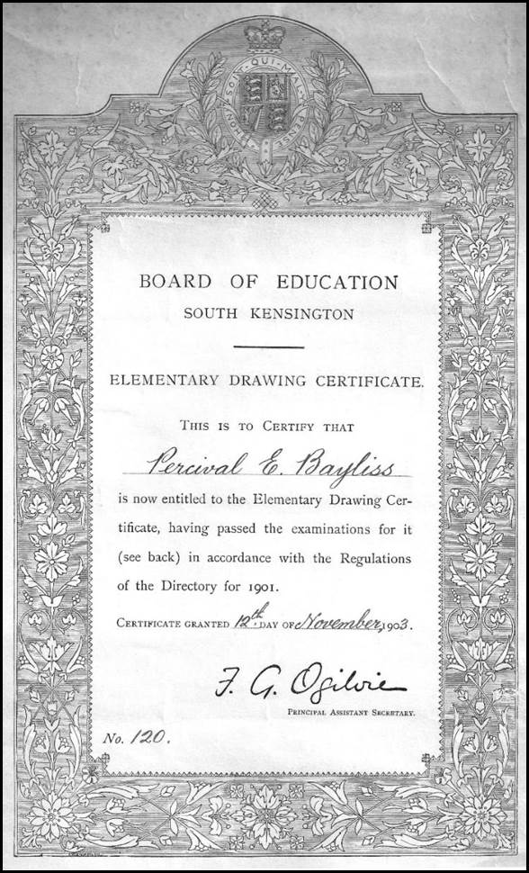
Percival Bayliss’s 1903 Drawing Certificate.
A Bayliss family image provided by Bruce Ryley.
Science and Art Department
The Science and Art Department was created as part of the Board of Trade in 1853 and expanded the existing Department of Practical Art. The new Department’s first Superintendent was Henry Cole. As well as science, the Department was involved in the practical arts, in other words, technology and design.
The Science and Art Department benefited substantially from the Great Exhibition of 1851. (Held at Hyde Park between May and October 1851, the Great Exhibition of the Works of Industry of All Nations was organised by Prince Albert, Sir Henry Cole, 1808-1882, and others.) Some of the proceeds of the Exhibition were distributed by its Commissioners for educational purposes. An Exhibition donation funded the acquisition of a large site at South Kensington that was to accommodate the Science and Art Department, the South Kensington Museum, and other bodies. In 1856, the Science and Art Department was absorbed by a new Education Department but retained considerable autonomy in promoting artistic and scientific higher education; especially for teacher training. The Science and Art Department took over the Government School of Design that was founded in 1837 and became the National Art Training School in 1853, and finally in 1896, the Royal College of Art.
During the 1880s, several Royal Commissions had addressed technical education. Recommendations from these Commissions led to an increasing role in scientific training for other branches of government. This increased attention to education led to the formation of the Board of Education in 1899, into which the Science and Art Department was fully integrated. Prior to the Board of Education, the structure of science education and national education more generally were seen as a virtually indescribable hybrid of half-reformed traditions and innovations. The new Board’s approach soon became a widely adopted education model.
Initially, the new museum arising from the Great Exhibition funding was known as the Museum of Manufactures but in 1854, when planning started for the move to the present site at South Kensington, it was renamed the South Kensington Museum. In May 1899, Queen Victoria laid the foundation stone for the Museum’s Aston Webb building. During this ceremony it was announced that the South Kensington Museum was to be renamed the Victoria and Albert Museum.
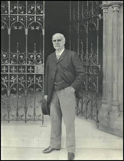
Sir William Abney at the Science and Art Department in 1901.
National Portrait Gallery, London image.
Sir William Abney (1843-1920)
Sir William de Wiveleslie Abney, RE, KCB FRS was born at Derby on 24 July 1843, one of the 5 children and eldest son born to the Reverend Canon Edward Henry Abney (1811-1892) and his wife Catherine née Strutt. (William was baptised on 10 August 1843.) In 1861, when 18 years old, William Abney left the Rossall Boarding School on the Irish Sea coast near Blackpool in Lancashire and attended the Royal Military Academy at Woolwich and joined the Royal Engineers. Abney served with the Royal Engineers in India for several years. He rose to the rank of Captain in 1873 and retired from the Royal Engineers in 1881. Abney continued to be known as Captain until becoming a Knight Commander of the Order of the Bath in 1900.
In 1864, William Abney married Agnes Matilda Smith (1843-1888) at York. There were 3 children from this marriage. In 1889, William Abney married Mary Louisa Mead; there was 1 child from this marriage.
In 1874, Captain Abney was a member of an expedition to Thebes in Egypt with Lieutenant-Colonel Archibald Campbell Campbell, 1st Baron Blythswood, FRS (1835-1908) to observe the transit of Venus; several other expeditions were present for this observation.
Abney invented a hand-held clinometer instrument known as the Abney level while employed at the School of Military Engineering in Chatham prior to late 1870. At Chatam, Lieutenant Abney was in charge of a small photographic and chemical laboratory. The Abney level was used by surveyors and others to measure slopes and angles. The Division of National Mapping used Abney levels for reconnaissance and other survey applications.
Abney’s instrument was described by 19th Century United States precision instrument makers W & LE Gurley as an English modification of the Locke hand level (Dr John Locke, 1792-1856, was a United States instrument maker.) Elliott Brothers of London Limited, (an instruments and later electronics company that operated from 1804 to 1967) registered an improved clinometer and spirit level combined in December 1870 based on the old form as originally designed by Lieutenant Abney.
An Abney level similar to those used by the Division of National Mapping.
Science Museum Group England image, object number:1914-220.
Abney’s scientific work involved mainly light, vision and associated subjects including photography. He was responsible for numerous books and handbooks which remained for a long time as standard guides for practical photographers who found all the technical advice needed in the information contained within them.
William Abney was active in a number of scientific societies. The first society he joined was the Royal Photographic Society in 1870 where he was elected President from 1892-94, in 1896, 1903 and again in 1905. In 1871, Abney became a Fellow of the Chemical Society. In 1876, he joined the Physical Society and was admitted as a Fellow of the Royal Society. From 1882 to 1884 Abney was on the Council of the Chemical Society. In 1893, Abney was elected President of the Royal Astronomical Society. From 1895 to 1897 Abney was President of the Physical Society. In all the societies that he joined, Abney obtained high honours.
In 1898, the first issue of Science Abstracts was published by The Institution of Electrical Engineers, London with Abney a member of the editorial committee. He was elected as Chairman of the Council by the Royal Society of Arts in 1903.
Abney’s later activities were mainly devoted to scientific education. He became a member of the Advisory Council for Education to the War Office. In 1899, Abney became assistant secretary to the Board of Education, South Kensington and advisor to that Board in 1903. In 1900, he became Director of the Science and Art Department. Failing health eventually curtailed Abney’s long and distinguished career and forced him into retirement. Sir William Abney died on 3 December 1920 at Folkestone, Kent; he was 77 years of age.
World War I Service Medals and Royal Engineers Badge
As mentioned in the body of the article above, Edward Percival Bayliss was awarded the British War Medal (1914-1918) and the Allied Victory Medal (1914‑1919) for his overseas service with the Royal Engineers during World War I. As he enlisted in December 1915, Percival did not qualify for either the 1914 Star or the 1914-1915 Star.
1914 Star
This medal was issued to British forces members who had served in France or Belgium from 5 August 1914 (the declaration of war) to midnight 22 November 1914 (the end of the First Battle of Ypres).
1914-1915 Star
This medal was issued to all British service personnel who served in any theatre of war outside the United Kingdom between 5 August 1914 and 31 December 1915, except for those eligible for the 1914 Star. Neither the 1914 Star nor the 1914-1915 Star were awarded alone. The recipients of these medals would also have received the British War Medal and the Victory Medal.
British War Medal (1914-1918): Army
The silver version of this medal was awarded to officers and men of the British and Imperial Forces who either entered a theatre of war (an area of active fighting) or served overseas (perhaps as a garrison soldier) between 5 August 1914 and 11 November 1918 inclusive and had completed 28 days of mobilised service. The qualifying service period was later extended for service in Russia, Siberia and some other areas in 1919 and 1920. A bronze version of the medal was also issued, mainly to members of the Chinese, Maltese, Indian, and South African Native Labour Corps.
The Allied Victory Medal (1914-1919)
World War I Allied nations each issued their own bronze Victory Medal but with a similar design, equivalent wording and identical ribbon. The ribbon colours represented the combined colours of the Allied nations. The British version of this medal depicts the winged figure of Victory on the front of the medal and, on the back, states: The Great War for Civilisation 1914-1919. To qualify for this medal, an individual had to have entered a theatre of war (an area of active fighting), not just served overseas.
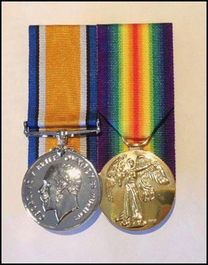
Percival Bayliss World War I British service medals.
British War Medal (1914-1918) (Army) on left and Allied Victory Medal (1914-1919).
Royal Engineers Badge
The Royal Corps of Engineers badge is depicted in the image below. Inside the laurel wreath under the crown of King George V is the inscription in Middle French: Honi soit qui mal y pense (Shame on him who thinks this evil). This is not the Corps motto but the motto of the Royal Order of the Garter. The central words in the badge G v R stand for George V Rex (George the Fifth King). The motto of the Royal Engineers is: Ubique and Quo Fas et Gloria Ducunt (Everywhere and Where Right And Glory Lead).
The Royal Engineers badge is the motif at the top of the headstone on Percival Bayliss’s grave in Canberra’s Woden Cemetery.
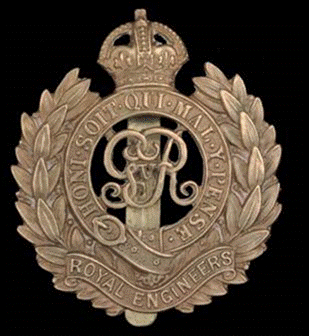
Royal Engineers World War I headdress badge.
Image from Imperial War Museums website.
Bayliss Family Immigration Vessels 1919-1924
About the SS Demosthenes
The triple screw steamer Demosthenes of some 11 200 gross register tons was built by Harland and Wolff in Belfast. She was launched on 28 February 1911 and was about 500 feet in length with a beam of about 62 feet and a draft of some 39 feet; she could make 14 knots. Demosthenes served as a troop ship in World War I and was scrapped in 1931.

Aberdeen Line’s SS Demosthenes.
Allan Charles Green (1878-1954) Collection image from State Library of Victoria website, ID H90.250/1654.
About the SS Ormonde
In October 1913 the keel for the new vessel for the Orient Steam Navigation Company Co Ltd was laid in the shipyards of John Brown and Co Ltd on the upper River Clyde off Dumbarton Road at Clydebank about 10 kilometres north west of central Glasgow. However, work on this vessel was postponed due to impending war needs. The new vessel was subsequently launched as a troopship in February 1917. Initially the unnamed vessel was coal-fired with 4 geared steam turbines and twin screws; she had a service speed of 18 knots with a maximum speed of about 25 knots. She was about 14 850 gross register tons when built and had a length of about 599 feet, a breadth of about 67 feet, and a draft of about 27 feet.
After fitout she was delivered to the Orient Line in November 1917 and registered as the Ormonde the following month. She then operated as a requisitioned troopship during the remainder of World War I and following months. In June 1919 the Ormonde returned to John Brown at Clydebank for refitting as a passenger liner with berths for 278 first class, 196 second class and 1 017 third class passengers.
Percival Bayliss’s brother-in-law and sister, John and Elsie Brighton, were on the Ormonde for her maiden voyage as a passenger liner from London to Brisbane. It departed on 15 November 1919. Afterwards she operated mainly on the Australia service as well as some tourist cruises. In the 1920s and 1930s the Ormonde had several refits including conversion from coal to fuel oil and passenger accommodation reconfigurations.
The Ormonde was again requisitioned as a troopship during World War II and afterwards operated mainly as a migrant ship between England and Australia. In 1950 she evacuated Dutch citizens from Indonesia and transported New Zealand troops to Korea. In late 1952 the Ormonde was sold to the British Iron and Steel Corporation to be broken up. Her demolition was completed by the West of Scotland Ship Breaking Co Ltd at Troon on the Firth of Clyde in west Scotland by May 1953 (Goossens, undated).
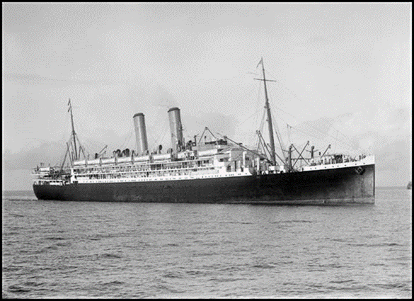
Orient Line’s SS Ormonde.
Allan Charles Green (1878-1954) Collection image from State Library of Victoria website, ID H91.250/80.
Other Bayliss family members in Australia 1919-2005
Elsie Bayliss (later Mrs J Brighton)
On 23 January 1918, Percival Baylisss’s younger sister Elsie married John Brighton in St Mathew’s Church in Marlborough Road Oxford, located about 300 metres south of the River Thames. At the time Private Brighton was on 14 days leave from the Australian Imperial Force’s 3rd Pioneer Battalion in France. Birth and Army records indicate that Elsie was 26 years of age and John was 24 years of age. John and Elsie Brighton were to have four children, daughters Joyce (later Mrs De La Rue), Hilda, Millie and Babbie.
According to his World War I Army service record John Brighton was born in Coventry (England) and enlisted in the Australian Imperial Force at Ararat, Victoria on 25 February 1916, Service Number 155. As mentioned, he served in France as a Private with the 3rd Pioneer Battalion from November 1916 and was hospitalised from a gas attack and with shell shock in June 1917 but rejoined his unit in September 1917. Private Brighton was posted to England in December 1918 and later that month joined the Australian Army Provost Corps at Tidworth about 110 kilometres south west of London. He spent the rest of his war service in England and was promoted Second Corporal in March 1919.
Elsie Brighton accompanied her husband to Australia at the end of the war. Second Corporal J Brighton and Mrs E Brighton were listed as passengers on the Orient Line’s SS Ormonde. (His service record clearly stated he was promoted to Second Corporal albeit a now defunct rank, but John Brighton appears to be erroneously listed as Lance Corporal on the AIF index records used by the Australian War Memorial.)
SS Ormonde departed London on 15 November 1919 under Master Hugh Geoffry Staunton on her maiden voyage as a passenger vessel after spending her initial years as a troop carrier. Nevertheless, on that voyage the Ormonde was repatriating a number of senior Australian Army officers as well as soldiers, some with wives (including some with children). Some 79 soldiers disembarked at the New Railway Pier (later called Princes Pier) at Port Melbourne after the Ormonde docked there on the morning of 26 December 1919. (The senior officers on the voyage included General Birdwood, who disembarked at Fremantle, and Lieutenant-General Sir John Monash, who disembarked at Melbourne.)
On a 1922 electoral roll John and Elsie Brighton were listed as residing at Valley Parade Camberwell and being respectively occupied as poultry farmer and home duties. John’s parents (John and Maria) were also listed as residing at that address and having the same occupations.
By 1924 Elsie and John Brighton were residing at Inwoods in Stamford Road Oakleigh, again with other members of the Brighton family.
On electoral rolls between 1924 and 1942 John Brighton and his father were listed as farmers while his wife and mother were listed as home duties. In 1936 Elsie’s parents Albert and Adelaide Bayliss were also listed as residing in Stamford Street Oakleigh and being respectively occupied as gardener and home duties.
On 19 January 1942 at age 48 years, John Brighton re-enlisted in the Australian Army (Citizen Military Forces) at Royal Park (Melbourne), Service Number V145850. John’s World War II Nominal Roll listing gave his date of birth as 8 April 1893. He served for over 6 years and was discharged on 7 October 1948 with the rank of Lance Corporal. At the time of discharge he was posted to the 103 Supply Platoon.
John Brighton was not located on electoral rolls after 1942. However, on electoral rolls for 1963 and 1967 his wife Elsie Brighton was listed as residing in Central Road Tarwin East and being engaged in home duties. It appears that John and Elsie Brighton moved to Tarwin East sometime after the completion of his World War II Army service in 1948 and most likely farmed there. Tarwin East is about 15 kilometres south east of Mirboo North in South Gippsland and about 150 kilometres south east of Melbourne.
John Brighton died at Tarwin East on 12 February 1957 and his remains were buried at Mirboo North cemetery. John’s age at death was 63 years. Elsie Adelaide Brighton died at Mirboo North on 11 August 1966 at 77 years of age; her remains were also buried at Mirboo North cemetery.
Alfred and Adelaide Bayliss
As mentioned, Edward Percival Bayliss’s parents Alfred and Adelaide Bayliss arrived in Melbourne in January 1924 onboard the Aberdeen Line Steam Ship Demosthenes. They were to spend the rest of their lives residing in the Melbourne area.
During their time in Melbourne, Alfred and Adelaide Bayliss were listed on electoral rolls as being occupied as gardener and home duties, respectively. They were listed as residing at various addresses: Classiford, Selby (1925), Winifred Street Oakleigh (1928), 9A Clyde Street Oakleigh (1931 and 1934), and Stamford Street Oakleigh (1936) which was also their daughter’s residence.
Alfred Edward Bayliss died at Bendigo on 29 July 1938; he was 75 years of age. Adelaide Sarah Bayliss died at her daughter’s residence in Stamford Road Oakleigh on 20 September 1942; she was 85 years of age. The remains of Alfred and Adelaide Bayliss were buried at Springvale Cemetery (Church of England, Compartment F, Section 14, Grave 48).
Doris Bayliss (later Mrs TF Ryley)
As mentioned in the text above, Percival and Lavinia Bayliss’s only child Doris was born in the Lambeth district of London on 17 April 1914. As a 9-year old child in December 1923, Doris immigrated to Australia with her parents and paternal grandparents onboard the Aberdeen Line Steam Ship Demosthenes. For her first few years in Australia Doris lived in Melbourne and then moved to Canberra with her parents around 1929. Here the Bayliss family resided at 34 Coranderrk Street Reid.
According to a report in The Canberra Times, in early July 1930 Doris Bayliss ceased duty in the staff branch of the Customs Department to take up a position with the Bureau of Scientific and Industrial Research (Anonymous, 1930). On electoral rolls for 1935 and 1937 Doris was listed as residing with her parents at 34 Coranderrk Street and being occupied as a typist.
On 3 August 1940, Doris Bayliss married Thomas Frederick Ryley eldest son of Frederick Abner Everard Ryley and his wife Minnie Ryley of Malanda (North Queensland). Thomas and Doris married in St John’s Anglican Church at the corner of Constitution Avenue and Anzac Parade Reid. The ceremony was performed by Archdeacon Charles Shearer Robertson. After the church ceremony a reception and dance was held in the Blue Room at the Hotel Canberra.
Thomas and Doris Ryley were to have two children, sons Thomas John (Jack) (1943-2019) and Bruce Gordon.
Thomas Frederick Ryley was born on 6 November 1914 in Normanton about 15 kilometres south east of Leeds in West Yorkshire, England. From the 1940s (at least), Thomas Ryley was an officer of Queensland Forestry; he held a Bachelor of Science (Forestry) degree and a Diploma from the Australian Forestry School. (The Australian Forestry School began at the University of Adelaide in 1926 and moved to Yarralumla 1927. It was reconstituted as the Department of Forestry at the Australian National University in 1965 and moved to the University campus in 1968.)
After their marriage Thomas and Doris Ryley resided at various locations in Queensland during the 1940s and 1950s. From electoral rolls, the locations they resided at included: Dalby (1943), Warwick (1949), Yarraman (1954), and Atherton (1958). Queensland Government Gazettes indicated that Thomas Ryley was a District Forester at Warwick in 1948 and in 1950 and he was a District Forester at Monto in 1952 (Nardella, 2019).
From 1963 the Ryleys settled at 14 Cedar Street Greenslopes which is about 5 kilometres south east of the Brisbane central business district. Cedar Street was to remain their family home for the rest of their lives. From around 1963, Thomas Ryley was the officer-in-charge of the Harvesting and Marketing Branch of the then Queensland Department of Forestry.
Between 16 March 1942 and 20 December 1943, Thomas Ryley served in the Citizen Military Forces with 1 Field Survey Company, Royal Australian Engineers. His Service Number was Q128697. 1 Field Survey Company was raised as an RAE Militia unit in Brisbane in early 1940. In 1942 the unit moved to Townsville and became 5 Field Survey Company in the Australian Survey Corps. The unit later operated on Cape York and then in Dutch New Guinea, Labuan and Balikpapan. It is not clear if Thomas Ryley served overseas. He was discharged with the rank of Sergeant.
Doris Ryley died in Brisbane on 9 August 1998 at age 74 years. Thomas Ryley died in Brisbane on 31 October 2005 at age 90 years.
Illuminated Address for the English Cricket Team 1937
The Canberra Times, Saturday 16 January 1937, page 2
Illuminated Address for MCC
The task of preparing the illuminated address for presentation to the MCC on the occasion of the visit of the All-England team to Canberra on February 11 and 12, which has been in progress since last July, is now nearing completion. The work has been carried out by Mr EP Bayliss and will shortly be handed over by him to the Federal Capital Territory Cricket Association for presentation to to the MCC team at some suitable time during the progress of the match.
The address is most artistic both as to conception, design and execution, and reflects the greatest possible credit on Mr Bayliss who worked on it for approximately 400 hours.
In order that the public of Canberra may have the opportunity of seeing the production it is proposed to arrange for its exhibition at business premises in the shopping centres, and a further announcement as to when it will be shown will be made in these columns. https://trove.nla.gov.au/newspaper/article/2421035
The Canberra Times, Friday 22 January 1937, page 2
ENGLISH TEAM ILLUMINATED ADDRESS DISPLAY FOR PUBLIC
Arrangements have been completed to exhibit the Illuminated Address prepared by Mr EP Bayliss for presentation to the MCC team, at Manuka, Kingston and Civic Centre and it is bound to attract a great deal of interest and favourable comment.
The frame in which the address has been placed is the gift to the Cricket Association of the Lord Mayor of Sydney (Alderman A Howie MLC) who has shown a keen interest in cricket in the Federal Capital Territory. Great pains were taken to secure high class seasoned timber for the work, and in this connection Mr AV Galbraith, Chairman of the Victorian Forestry Commission has assisted by providing fiddleback Blackwood to make the frame. The maple silkwood timber mount selected by Mr Howie is beautifully marked and blends perfectly with the blackwood of the frame.
The production is of high artistic merit and those who view the address will understand and share the gratification officials of the Cricket Association have in having such a worthy souvenir to present to the MCC team. The souvenir will be on view at Carnall Sports Depot, Manuka Arcade, within the next few days. https://trove.nla.gov.au/newspaper/article/2421736
The Age, Thursday 28 January 1937, page 10
CANBERRA VISIT Unique Illuminated Address.
CANBERRA, Wednesday — An illuminated address which Mr EP Bayliss of Canberra, took six months to prepare, will be presented to the MCC team by the Federal Capital Territory Cricket Association at an official luncheon in Canberra on 10th February, when the English Eleven will commence a two‑days match against a combined country team. The address embodied the monograms of the MCC and the FCT Cricket Association, the Coat of Arms of Australia in a central position, and those of the States arranged within the border of laurels. The Coat of Arms of the City of London, the Canberra Coat of Arms and a drawing of the Federal Parliament House are also included.
Special arrangements have been made by the Canberra Chamber of Commerce for all local shops with the exception of cafes, to close from noon on 10th February. https://trove.nla.gov.au/newspaper/article/206180597
Morning Bulletin (Rockhampton), Thursday 11 February 1937, page 11
English Team’s Visit to Canberra: Illuminated Address Presented
CANBERRA, February 10: To commemorate the first visit of an English team to Canberra a framed illuminated address, the gift of the Federal Territory Cricket Association, will be taken home by the team and hung in the pavilion at Lord’s. It was presented to Allen* at a luncheon to the English players today by the Minister for Customs (Mr TW White), representing the Prime Minister.
Allen said that the English team should always come to the Australian capital. Acknowledging the presentation, he said that the address would have a permanent place in the pavilion at Lord's. Referring to the fight for the Ashes, Allen said that when he landed in Australia he did not give themselves a monkey's chance, but now he was very optimistic. So don't be disappointed when we win, he added. (In fact Australia won the Ashes series 3-2, after losing the first 2 test matches.)
*English Team Captain (later) Sir George Oswald Browning Gubby Allen CBE (1902‑1989); an Australian-born, English-educated Middlesex batsman and fast bowler who had refused to use bodyline tactics in the early 1930s.
https://trove.nla.gov.au/newspaper/article/55583552
Pictorial Map of the Northern Territory 1938
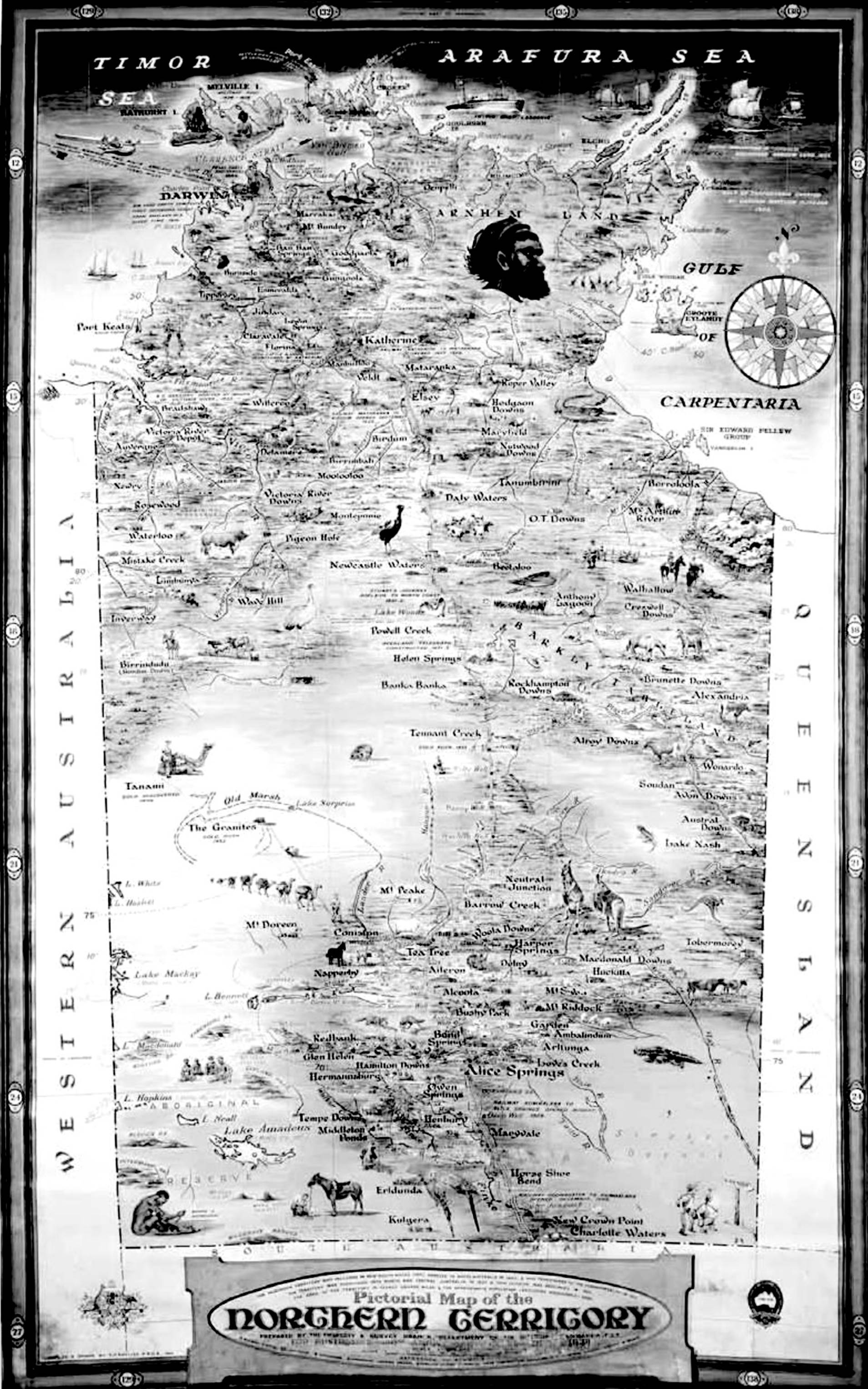
Pictorial Map of the Northern Territory (monochrome copy).
Source: Ling (2011), page 5; National Archives Australia Research Guide.
The Canberra Times, Mon 11 Apr 1938, page 2
Unique Map By Canberra Draftsman Displayed at Sydney Show
The Minister for the Interior (Mr McEwen*) stated yesterday that a unique map of the Northern Territory would be displayed as part of the Northern Territory exhibit at the All Australian Exhibition and Trades Fair at the Royal Agricultural Show, Sydney.
The map, which measures 10 feet by 6 feet, was prepared by Mr EP Bayliss, draftsman of the Property and Survey Branch at the Department of the Interior, Canberra.
The projection selected gives a minimum distortion, and all topographical features are correctly plotted, from latest survey information available—the coastline, mountains, rivers and watercourses being clearly indicated. The colouring of the groundwork of the map is intended to convey the disposition of the various land areas by climatic conditions and for the climatic conditions, the latest information from the Meteorological Bureau has been incorporated.
The homesteads and many buildings are drawn from actual photographs and are readily recognised by persons who have visited the Territory, various types of natives and their occupations, special fauna, permanent wells and bores, stock routes, wireless, pastoral industries, mining industries, the contrast in methods of transportation, aboriginal reserves and stations, aerodromes, emergency landing grounds, lighthouses, railway, police and telegraph stations are clearly marked, whilst the overland telegraph line, AIM** Hospital and the Flying Doctor's plane are illustrated, and even the pearling vessels—Australian and Japanese—have not been forgotten.
Many notes referring to the early history and subsequent development of the Territory are given. Mr McEwen added that the preparation of the map involved a considerable amount of research an arduous work on the part of the officer who drew it. It is proposed to have it copied in a reduced form and made available to schools.
*John McEwen (1900-1980) later Sir John, who became leader of the then Country Party, Deputy Prime Minister and briefly Prime Minister for a few weeks (1967-1968).
**Australian Inland Mission.
https://trove.nla.gov.au/newspaper/article/2455902
The Central Queensland Herald (Rockhampton), Thursday 28 April 1938, page 58
Pictorial Map of Northern Territory: From Our Special Representative, Canberra, 16 April 1938
At the present time a great deal is being said and written about the Northern Territory and the need for a more progressive development policy on the part of the Commonwealth Government. To what extent it is capable of development, owing to climatic and other conditions, it is difficult to say, but it is certainly able to carry many more thousands of white people than are settled there today. All told, there are only about 4 000 whites in the Territory ‑ a fact that is the subject of comment by certain land hungry nations.
Neither at home nor abroad is there a proper understanding of the problems and resources of the Northern Territory, but an effort has been made by the Department of the Interior to set them out by means of a pictorial map which is now on view at the All Australian Exhibition and Trades Fair at the Royal Show in Sydney. This map measures 10 ft by 6 ft, and is the work of Mr EP Bayliss, of the Property and Survey Branch of the Department. Mr Bayliss is a noted cartographer, and his work on the Australian section of the international map of the world has won for him a big reputation abroad.
This Northern Territory map, however, is something unique. The colouring of the groundwork is intended to convey the disposition of the various land areas determined by climatic conditions, nature of the soil, etc. — well watered pastoral and agricultural country, pastoral country with little or no permanent water, well grassed plains, and also desert country. In regard to the climatic conditions, the latest information from the Commonwealth Meteorological Bureau has been incorporated. Isotherms indicating mean annual temperature in degrees Fahrenheit, and isohyets indicating mean annual rainfall are shown in appropriate symbols.
The projection selected gives a minimum distortion, and all topographical features are correctly plotted from the latest survey information, coastline, mountains, rivers, and water courses all being clearly indicated. A number of the homesteads, mission stations, and similar establishments are shown on the map. The drawings have been made from photographs and are readily recognised by persons who have visited the Territory. Pastoral industries, such as cattle, horse and sheep breeding, are illustrated, whilst the districts in which goats and camels are numerous are also shown, together with the aboriginal reserves and various types of natives and their occupations.
A Land of Contrasts
The map affords a striking illustration of the contrasts in the methods of transportation in the Territory, the large Imperial Airways mail plane, the transcontinental railway, camel trains, donkey teams, and motor transport being clearly depicted.
Typical fauna is represented by kangaroos, emus, crocodiles, buffalo, lizards, ibis, cockatoos, parrots, geese, and other game. The coastal area of the Territory is undoubtedly a sportsman's paradise.
Permanent wells and bores, stock routes, wireless stations, aerodromes, emergency landing grounds, lighthouses, railway, police and telegraph stations are distinctly marked, and the overland telegraph line, AIM hospital, and the flying doctor's plane may also be found on the map by those who care to search.
Mining industries are portrayed by illustrations of mines, batteries, etc and there is even a drawing of a prospector. Here Mr Bayliss shows a vein of humour, for the prospector (in the south-east corner) is gazing up at a signpost on which is printed: To the Harbour Bridge — 1 000 miles.
Even the pearling vessels — Australian and Japanese — have been remembered and a representative of the Northern Territory police force is also shown.
And one may read, here and there, on the map little bits of Australian history and data of value to anyone interested in the Northern Territory and its development. There is now on exhibition at the first Australian Academy of Art Show in Sydney the picture by Ivor Hele, of South Australia — Sturt's Reluctant Decision to Return — which was awarded the Commonwealth Art Prize in connexion with the 150th Anniversary Celebrations. The spot where Sturt made his decision is marked by Mr Bayliss on his map. He has omitted nothing of importance.
The preparation of the map involved a considerable amount of research and arduous work, and the greatest credit is due to the officer responsible for it. The Minister for the Interior (Mr John McEwen) states that it is proposed to have it copied in a reduced form and made available to schools.
https://trove.nla.gov.au/newspaper/article/70579016
Pictorial map of the Northern Territory for Australia's 150th Anniversary celebration 1938, reproduced by Northern Territory Department of Lands and Housing, Darwin, 1990.
Facsimile reprint. Originally published in Canberra by the Property and Survey Branch of the Department of the Interior in 1938 as colour map 43 x 26 cm. Compiled and drawn by Edward Percival Bayliss FRGS 1937.
Physical Description
1 map: colour; on sheet 51 x 34 cm. 1 map: colour; on sheet 90 x 58 cm.
Subjects: Agricultural industries, Land tenure, Real property, Pictorial works. Scale 1:678 000.
Notes
The Northern Territory was included in New South Wales until annexed to South Australia in 1863, and was transferred to the Commonwealth in 1911. The Territory was subdivided (at the 20th parallel) into North and Central Australia in 1927 and this division was rescinded in 1931. The area of the Territory is 523 620 square miles and the approximate population (excluding Aboriginals) 5 000. Reference to symbols: includes railway station, lighthouse, aerodrome, emergency landing ground, wireless station. Annual mean temperature isotherms in °F. Annual rainfall in isohyets in inches.
Edited listing from National Library of Australia, Catalogue
https://trove.nla.gov.au/work/229066819
John Stanley Cumpston (1909-1986)
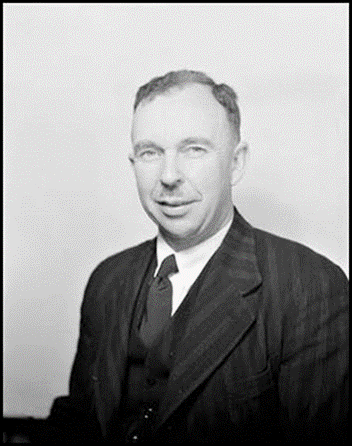
John Stanley Cumpston 1953.
National Archives of Australia image (A1200, L16196 Item barcode 7534334).
John Stanley Cumpston was born in Perth, Western Australia on 3 June 1909. He was the first of 7 children born to John Howard Lidgett Cumpston (1880‑1954) and his wife Gladys Maeva née Walpole (1887-1975). (The Melbourne-born JHL Cumpston was a medical practitioner, public health specialist and the first Director‑General of the Commonwealth Department of Health. Gladys Cumpston was a community worker, horticulturist, and later in life a Braille transcriber.) JS Cumpston studied at The University of Melbourne where he gained the degrees of Bachelor of Arts (Hons), 1930; Bachelor of Laws, 1932; Diploma of Public Administration, 1939; and Doctor of Letters, 1949. JS Cumpston was admitted as a barrister and solicitor of the Supreme Court of Victoria in 1933. Cumpston joined the Commonwealth Public Service in 1934 and after working in the Crown Solicitor’s Office Sydney he transferred to the Department of External Affairs Canberra in 1935.
Map of Antarctica and Handbook 1939
As a Department of External Affairs officer, John Stanley Cumpston undertook extensive geographical and exploration history research on Antarctica in the late 1930s. Cumpston’s research was used by Percival Bayliss in the compilation and drawing of a 1:10 Million scale map of Antarctica that was completed in 1939. Together Bayliss and Cumpston prepared a 90-page handbook and index to accompany the map. For this work Cumpston was elected a fellow of the Royal Geographical Society, London in 1940 (Hinks, 1940 in Appendix H).
Army service 1920s-1940s
In October 1940, John Stanley Cumpston joined the Second Australian Imperial Force; service number NX70393. At that time he had some 14 years prior military experience in various Militia units. During the 1920s Cumpston had joined the 14th Infantry Battalion that was then a Militia unit known as the Prahran Regiment. In May 1932, Cumpston was appointed a Lieutenant in the then Melbourne University Rifles (now the Melbourne University Regiment) and on 29 May 1933 he was promoted Captain.
In November 1934, after his Commonwealth Public Service employment had taken him to Sydney, Cumpston transferred to the 9th Field Brigade Royal Australian Artillery that was then a Paddington-based Militia unit later assigned to the 2nd Division where it served until World War II. In May 1936 Cumpston was posted back to the Melbourne University Rifles until January 1937 when he joined the 53rd Infantry Battalion which was then known as the West Sydney Regiment. For a short period in 1936-1937 it was amalgamated with the 3rd Infantry Battalion (The Werriwa Regiment) but in August 1937 the 3rd Battalion resumed its own identity and was based around the Goulburn area as part of the 14th Brigade (together with the 55th Infantry Battalion).
In August 1940 Cumpston was transferred to the Retired List of Officers (Infantry) but in October 1940 was seconded to the Second Australian Imperial Force with rank of Lieutenant for service with the 2/23rd Infantry Battalion as Liaison Officer with the 26th Infantry Brigade that was then in the 7th Australian Division. As well as its Headquarters, the Brigade comprised the 2/23rd, 2/24th, and 2/48th Battalions. The 2/23rd Infantry Battalion Albury’s Own had been raised in July 1940 by the then 35-year old temporary Lieutenant-Colonel Bernard Evans (1905-1981) (later Brigadier Sir Bernard Evans DSO) who commanded the Battalion until November 1942 (Dunstan, 2007).
Tobruk
On 16 November 1940 Lieutenant Cumpston with the 26th Infantry Brigade embarked at Port Melbourne on the troop transport vessel Strathmore, a requisitioned 23 000 gross register tons P&O liner. The 26th Infantry Brigade arrived in Egypt in mid-December 1940 and early in 1941 was reassigned from the 7th Australian Division to the 9th Australian Division. Afterwards the 26th Infantry Brigade was sent to the Cyrenaica region of eastern Libya.
In late March 1941 Lieutenant Cumpston was stationed at Tocra about 300 kilometres west of the Mediterranean port of Tobruk with the 26th Infantry Brigade. From early April 1941, the 26th Infantry Brigade was part of the garrison during the Siege of Tobruk that was to last for eight months. Most of the 9th Australian Division including the 26th Infantry Brigade was withdrawn from Tobruk in late October 1941.
Palestine
On 29 May 1941, however, Lieutenant Cumpston left Tobruk as he had been requested for secondment to the 26th Australian Infantry Training Battalion and was posted to the AIF Reinforcement Depot at Mughazi (today Maghazi) in the Gaza area of Palestine. Here he served as the Battalion’s Adjutant under Commanding Officer Major Henry McKean (Harry) Tasker. On 2 September 1941 Lieutenant Cumpston was promoted Captain.
For his service with the 26th Australian Infantry Brigade between July and October 1941 Captain Cumpston was awarded a Mention in Despatches. This award was promulgated on page 2857 in the London Gazette of 30 June 1942. During the period cited in the award, Cumpston was the Adjutant with the 26th Australian Infantry Training Battalion in Palestine.
Lebanon Ski School
On 12 December 1941, Captain Cumpston was posted to the 1st Australian Corps Ski School that had been established the previous month at the Hôtel des Cédres near the historic Cedars of God; a remnant stand of about 300 ancient cedar trees. The hotel was about 4 kilometres east of the town of Bsharri (Romanised as Becharré). Bsharri is located about 30 kilometres south east of the northern port city of Tripoli which is about 70 kilometres north of Beirut, the capital of Lebanon. The altitude at Bsharri ranges from about 1 450 metres to over 3 000 metres.
The first Commandant of the School was Major Robert Watkin Savage (1906-1977), a Signals officer with the 9th Australian Division. The Ski School had staff of around 10 instructors. Throughout the life of the School the Chief Instructor was British Army Major Williams James Riddell. The 1st Australian Corps Ski School operated from 2 December 1941 to 26 February 1942. During this period, three separate courses of varying durations were run with a total of about 200 students participating.
The School was apparently established with the intention of training mountain troops to operate on skis in winter and in mountainous terrain in summer. It was initially envisaged that each of the three Australian Divisions then deployed in the Middle East (the 6th, 7th, and 9th Australian Divisions) would have a specialist company of mountain troops. These troops would take part in reconnaissance and fighting patrols. As well as skiing skills, the training at the 1st Australian Corps Ski School was to cover camping above the snow-line, tactics in offensive and defensive patrols, signalling and intelligence duties.
From 24 January 1942 the School became the responsibility of the 9th Australian Division and the 9th Australian Division Ski Company was established under the command of Captain John Stanley Cumpston. About that date, Major Hylton Ernest (HE) Williams (1898-1968) (formerly Headquarters Royal Australian Artillery, 9th Australian Division) replaced Major Savage as Commandant.
Some further brief information on the 1st Australian Corps Ski School and the 9th Australian Division Ski Company together with a few of the personalities involved is provided in Appendix L.
On 19 February 1942, Captain Cumpston rejoined the 2/23rd Infantry Battalion that was then undertaking fortress defence duties in the Tripoli area of Lebanon. Between March and the end of June 1942 Captain Cumpston was attached to the Battalion’s D Company, mainly as acting second-in-command or as a supernumerary.
El Alamein
On 26 June 1942 the 2/23rd Infantry Battalion commenced travel (in a vehicle convoy) from the Tripoli area of Lebanon to the Alexandria area of Egypt. Over the first few days of July 1942 the Battalion set up a position at Amiriya about 20 kilometres south west of Alexandria and about 80 kilometres east of the El Alamein railway station. On 9 July 1942 most of the Battalion moved into battle positions near where heavy fighting occurred until the last few days of the month.
At El Alamein the 2/23rd Infantry Battalion suffered heavy casualties during the month of July 1942 including 19 officers killed in action (8 of whom were company commanders) and one officer taken prisoner of war, 43 non‑commissioned officers and some 240 other ranks; in all about 75 per cent of its rifle company strength.
Captain Cumpston was left out of the battle of El Alamein. He was one of 6 officers and 54 other ranks who maintained a defensive position at Amiriya. This group rejoined the Battalion on 14 August 1942 with Captain Cumpston being assigned to Headquarters Company.
Between 19 October and 12 November 1942 Captain Cumpston attended No 7 Course at the Middle East Gas School. (He was thus away from the Battalion when it fought in the second battle of El Alamein that occurred during 23 October-11 November 1942.) Later in November 1942 he was admitted to the 2/6th Australian General Hospital (then located at Gaza Ridge in Palestine) with a not yet determined illness thought to be sandfly fever.
Afterwards Captain Cumpston was placed on the Permanent Supernumerary List (wounded) and attached to the 1st Australian Depot Battalion in December 1942.
On 30 December 1942 Captain Cumpston was transferred from 2/6th Australian General Hospital to the 2/1st Australian Convalescent Depot; his medical condition was then listed as hepatitis. On 29 January 1943 Captain Cumpston embarked in the Middle East on transport L3 for return to Australia and disembarked in Sydney on 27 February 1943.
Allied Geographical Section
On 25 March 1943 Captain Cumpston was transferred from the Permanent Supernumerary List and posted as a Staff Captain (Intelligence Officer) to the Allied Geographical Section, General Headquarters, South West Pacific Area that was located in Brisbane. Over the next two years Captain Cumpston worked on various geographical studies including the Terrain Handbooks and Terrain Studies that were produced by the Allied Geographical Section. (Further information on the Section and its work is provided above in the main body of this article under Report on the Allied Geographical Section 1944.)
Between 22 and 31 March 1945 in connection with his work with the Allied Geographical Section, Captain Cumpston flew from Brisbane to the island of Biak which is one of the Schouten Islands in Cenderawasih Bay off the north coast of the present day Indonesian province of Papua (in western New Guinea). A few days later he flew on to Leyte the seventh largest island in the Philippines. Captain Cumpston returned to Brisbane after again overnighting at Biak.
Army Discharge
Captain Cumpston was discharged from the Second AIF in Sydney on 25 April 1945 and transferred to the Reserve of Officers. He was awarded the Australian efficiency decoration in August 1947. Captain Cumpston was placed on the Retired List of Officers (Intelligence) in June 1956.
Post-war service with External Affairs
After his 2 AIF discharge, John Stanley Cumpston returned to the Department of External Affairs. He became the first secretary of the Australian Mission in Chile (Santiago) (1946‑1949), official secretary to the Australian High Commissioner in Wellington, New Zealand (1950-1953), consul in Noumea, New Caledonia (1953-1958) and consul in Dili, Portuguese Timor (January‑March 1963). In 1960, Cumpston became the Department of External Affairs historian and held that position until he retired in July 1969.
Post-retirement in Canberra
JS Cumpston was very active in the Canberra community after his retirement. As well as community service, his post-retirement endeavours included writing and publishing. John Cumpston helped to establish the Sir Leslie Morshead War Veterans’ Home at Lyneham, St Luke’s Church of England at Deakin, and the Brindabella Gardens retirement home in Curtin. He served as President of the Canberra and District Historical Society (1973-1975) and President of the Australian Capital Territory branch of the Rats of Tobruk Association (during 1958‑1967 and again in 1983). As listed below John Cumpston is known to have written several books in the 1960s and 1970s. He established and funded the Roebuck Society as a publishing company to provide an outlet for books of merit on Australian historical subjects not otherwise published. Before his death, the Society had produced over thirty publications (Henderson, 2007).
Vale
John Stanley Cumpston died on 6 August 1986 at the Royal Canberra Hospital, he was 77 years of age. John Cumpston was survived by his wife of 46 years Helen Ida née Dunbar (1910-2005) and their four children. His remains were cremated at Canberra’s Norwood Park Crematorium on 8 August 1986 and the ashes placed in Row 3 of the left side wing of the Ex-Service Wall. Helen Cumpston died on 11 July 2005 at age 95 years and the ashes of her remains were later placed with those of her late husband at Norwood Park.
Publications
Known publications by JS Cumpston include:
· Handbook and Index to accompany a Map of Antarctica (with EP Bayliss); Department of External Affairs, Canberra, 1939, 90 pages
· Shipping Arrivals and Departures Sydney 1788-1825; 164 pages, 1963 (reprinted by Roebuck Society, Canberra, 1977)
· The Rats Remain: Tobruk Siege 1941; Grayflower Productions, Melbourne, 1966, 256 pages
· Macquarie Island; Department of External Affairs, Antarctic Division, Melbourne, Publication No 93, Australian National Antarctic Research Expeditions Scientific Reports, 1968, 380 pages
· Kangaroo Island 1800-1836; Roebuck Society, Canberra, 1970 (First Edition), 218 pages
· First Visitors to Bass Strait; Roebuck Society, Canberra, 1973,103 pages.
The National Library of Australia holds material submitted by JS Cumpston for the degree of Doctor of Letters that was awarded by The University of Melbourne in 1949, this material apparently includes the Handbook and Index to accompany a Map of Antarctica as well as five books issued by Allied Geographical Section, South West Pacific Area, namely:
· Lae and the lower Markham Valley, Terrain Handbook 4
· Sio (Huon Peninsula New Guinea), Terrain Handbook 13
· Negros Island and Siquijor Island, Terrain Handbook 52
· Negros Island and Siquijor Island, Terrain Study 99
· Vegetation Study of the Philippine Islands.
The National Library of Australia also holds several sound recordings by JS Cumpston as well as numerous papers pertaining to him.
Cumpston Massif Antarctica
Cumpston Massif in Antarctica is a prominent, flat-topped rock outcrop, about 2 070 metres high, 14.5 kilometres long and between 7 to 13 kilometres wide. Cumpston Massif is located at the junction of the Lambert and Mellor Glaciers in Mac Robertson Land at 73° 36' S 66° 48' E; about 670 kilometres south of Mawson Base. The feature was discovered in November 1956 from an Australian National Antarctic Research Expeditions aircraft. The massif was subsequently named for Dr JS Cumpston of the Department of External Affairs who with cartographer EP Bayliss was responsible for preparing the map of Antarctica published in 1939 by the Department of the Interior. A satellite image of Cumpston Massif is provided below.
Originally this feature was named Patrick Point for 1956 Expeditioner Patrick Albion. Patrick Point now only refers to the northern point of the subsequently renamed Cumpston Massif. As mentioned above the original feature was mapped from aerial photographs taken during a major ANARE flight by Flying Officer John Seaton in November 1956. This whole feature was then named for Patrick Albion who was the radio operator at Mawson Station during 1956 and the camera operator on John Seaton’s subject flight.
While believing that John Cumpston is thoroughly deserved of an Antarctic feature to his name, Nat Mapper Syd Kirkby, a recognised and significant Antarctic surveyor and explorer (who wintered at Mawson in 1956-57) has for many years been incensed that the Australian Antarctic Division Place Names Committee (and its predecessors) has chosen to over-name this and other features already credited to past expeditioners.
Cumpstons Cottage Macquarie Island
Cumpstons Cottage is a prefabricated two storey timber house at the Australian National Antarctic Research Expeditions station on Tasmania’s sub-Antarctic Macquarie Island which is located about 1 500 kilometres south east of Hobart. Cumpstons Cottage was named for the late John Stanley Cumpston. The cottage was erected during the summer of 1995–1996. Cumpstons Cottage comprises living quarters for the Macquarie Island station leader, doctor and chef as well as the station leader’s office.
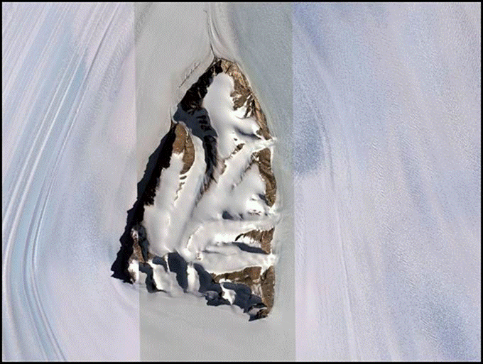
Cumpston Massif Antarctica.
United States Geological Survey satellite image from Google Earth.
Review of Map of Antarctica at 1:10 Million scale 1939
The following is a review of the 1939 map of Antarctica and the accompanying Handbook and Index by Edward Percival Bayliss and John Stanley Compton. The review was written by British astronomer and geographer Arthur Robert Hinks (1873-1945) and appeared in The Geographical Journal, Volume 96, No 6, December 1940, pages 435-438; published by The Royal Geographical Society, London.
A NEW MAP OF ANTARCTICA
Handbook and Index by EP Bayliss and JS Cumpston to accompany a Map of Antarctica. Canberra: Commonwealth of Australia Department of External Affairs, 1939. 10 X 6½ inches; 90 pages; map
The Preface to the Handbook is written by the Minister for External Affairs, whose Department collected material from many sources, and by the Minister for the Interior, whose cartographer compiled and produced the map, Mr JS Cumpston, for the former, has brought together, in the chapter Antarctica, a very useful summary of work since 1925 by the ships of the Discovery Committee, the BANZARE* under Sir Douglas Mawson in 1929-31, the Norwegian expeditions of and for Mr Lars Christensen in 1926-37, Admiral Byrd's expeditions of 1928-30 and 1933-35, the flights of Sir Hubert Wilkins and Mr Lincoln Ellsworth, the British Graham Land Expedition of 1934-37, and the German Antarctic Expedition of 1938-39.
A brief introduction to this chapter recalls that Captain Cook was once bold enough to say that no man will ever venture farther than I have done: and that the lands which may be to the south will never be explored. It quotes also from Lars Christensen the improbable compliment to Palmer put into the mouth of Bellingshausen by Palmer's biographers, which we have recently discussed (Geogr. J. 87 [1939] 322). The first landing on any part of the Continent other than the northern parts of Graham Land was made from Bull's ship Antarctic in 1895, though the expedition led by Borchgrevink in 1898-1900 called its book First on the Antarctic Continent. This exception of Graham Land seems to overlook the fact that Biscoe's landing was on an island. After a very brief summary of events between 1900 and 1910, in which neither Scott's first nor Shackleton's first expedition is mentioned, we come to the culmination of the non-mechanical period in 1912, and after the long gap caused by war the beginning of the post-war period with the first voyage for the Discovery Committee in 1925.
A statement of the Imperial Conference of 1926 on existing British titles by virtue of discovery should surely have been prefaced by some mention of the Falkland Islands Dependency proclaimed in 1908 and the Ross Dependency in 1923. And since in making the map the principle adopted in the choice of names has been in general that the ultimate decision on the names to be adopted in any territory lies with the Government of that territory, it would have been well to mention the Order in Council of 1933 establishing the Australian Antarctic Territory, which was not proclaimed in the Commonwealth Gazette until 1936. These four important dates are relegated to a later section IIIb on Boundaries.
The summary of fifteen years' continuous work by the Discovery, Discovery II and William Scoresby is placed first in its proper precedence, as the finest example of a scientific enterprise directed always to ends of urgent importance, to understand the physical conditions and the natural laws which govern the life of the whale in its immense and until lately badly surveyed habitat. It has been a race with time, to learn how the catching might with international good will be wisely regulated before the profits to be snatched from unlimited pelagic whaling with factories and catchers on the high seas did irremediable damage.
Rivalling the Discovery Committee's work in extent, with larger forces and somewhat different aims, came the Norwegian enterprises controlled by Lars Christensen, combining enormous commercial interests with an ambitious and very successful programme of scientific exploration and survey. The earlier cartography is in the charts of the Norwegian Whalers' Association; the other scientific results already make a fine series of volumes published by the Norwegian Academy of Sciences; and one may add to Mr Cumpston’s excellent chronicle that the air surveys are or were being worked up with the stereoplotter of the Norges Geografiske Opmaling.
Arising directly from the Imperial Conference of 1926 came the expeditions of Sir Douglas Mawson in 1929-31, promoted by the Commonwealth and New Zealand Governments, assisted from Great Britain by the loan of the Discovery, and supported financially by Sir MacPherson Robertson and other Australians. Largely upon the results of this timely enterprise was based the Australian claim to its Antarctic Territory, with its curious enclave of Adélie Land, of which the coast was discovered by Dumont d'Urville in 1840, was surveyed by the Australasian Antarctic Expedition in 1912, and was proclaimed a National Park and Nature Reserve by the French about 1926, and was converted into a French sector by Decree of 1 April 1938.
A merit of these accounts, and of those that follow, is that they are dry compilations of events, dates, and names, quite impersonal and uncritical: the author has collected the bare facts from the extensive scattered literature and condensed the history of twenty years into fifty pages. Such economy makes it impossible to give references to authorities. An exception is made for Discoveries in Graham Land (1819-1937) compiled for use with a small map of Graham Land inserted at the end of the book, with an attempt, not quite successful, to assign the first discoveries in this debated region.
To Bransfield is given a short piece of Continental coast eastward from the mouth of the Orleans Channel, to Palmer and Powell (who never was there) the coast south and south-west of Trinity Island. The three seem to share between them the discovery of Deception Island. It would want a map on a much larger scale and a different representation, by track rather than by area, to disentangle the history.
Table IIB gives a list of the authorities using the word rather loosely, for they are not always the original authorities: one would not expect a memoir of the American Philosophical Society dated 1939 to be cited as the authority for H Foster in 1829 or J B Charcot in 1908‑10.
How the map was compiled is described by Mr EP Bayliss, Cartographer to the Department of the Interior. All available documents were consulted, and additional information was collected from recent explorers themselves. The map is the first to show the boundaries assigned to Lands within the Australian Antarctic Territory. The bathymetric contours have been replotted by taking into account over five thousand modern soundings additional to those shown on Admiralty Charts up to 1937. The place of the Magnetic Pole has been recomputed by Dr C Coleridge Farr, and a table of former determinations is given on the map; it appears to be moving north-westerly about 4 miles per year.
The map is plotted on the Azimuthal Equidistant projection, to which is attributed the curious property that all great circles pass through the centre of the map and are represented by straight lines intersecting at their true angles.
There are lists of Geographical Positions accepted, additional to those given in the Antarctic Pilot 1930 and Admiralty Charts; a table of Boundary Definitions with the authority; a most useful statement of the authorities accepted for each segment of coastline and for topographical details; and a Bibliography of works consulted, though not necessarily followed; with, finally, an Index to Names on the Map.
Such a Handbook provides a most valuable critical apparatus for studying the map, and the authors as well as their Chiefs are to be congratulated on having gathered so much into a slight book of ninety pages.
The map is excellently printed in eight colours by the Government Printer, Canberra. It is produced from the same drawings in two sizes: a single sheet with engraved surface 27¾ x 36½ inches, the latitudinal scale 1/10M**, with inset of the Australian Antarctic Territory's coast on 1/7M; and in two sheets, with a small overlap, 37 x 25½ and 37 x 24¾ inches; with scales 1/7½M and 1/5¼M.
The projection is Polar azimuthal equidistant; the horizontal meridian is 0⁰ left to 180⁰ right so that 90⁰ east is at the top, and the AAT in the upper half; the names are written more or less parallel to the lower edge, so that the map can be read in one position; in all these matters the map differs from the Admiralty South Polar Chart No 1240, which is on the gnomonic projection, has 180⁰ at the bottom, and names along the parallels, to be read from the South Pole at the centre. Heights and soundings are in metres instead of in feet and fathoms. The boundaries of political sectors, the subsidiary divisions of sectors with Lands and Coasts, are shown in red, instead of being omitted; the inland topography, mountains and glaciers, is well drawn in colour.
The Commonwealth Government take a firm line in the matter of names: they are the only authority on names within their Antarctic Territory. They have exercised this authority with a generous regard to the desires of explorers and the feelings of their countrymen, so that few principal names proposed by any side have been omitted, though some have been given a Coast instead of a Land. Only Wilkes has both, and the extent of his Land, no less than 34⁰ of longitude, should have made it unnecessary for an American Professor to weary the Symposium at Philadelphia in February last with his tale of British perfidy, while having to admit in his last sentence that Wilkes*** had after all obtained his deserts.
The AAT has henceforth nine Lands, bearing the names of Oates, King George the Fifth, Wilkes, Queen Mary, the Kaiser Wilhelm II, the Princess Elizabeth, Mac-Robertson, Kemp, and Enderby, in that order from east to west. To the Coasts within these Lands are assigned the names Wilkes, Banzare (BANZARE) Sabrina, Knox, King Leopold and Queen Astrid Coast, formerly Princess Astrid Land (but a different Astrid), Ingrid Christensen, and Lars Christensen.
One cannot but regret that Lars Christensen who has done so much for the exploration of these Lands between 94⁰E and 20⁰W, should not have a Land of his own; but his officers coveted for him one of the few important stretches of coast for which he is content to accept in the main the survey of others; and his maps proposed names entirely of the Norwegian Royal Family for the sector between 45⁰ and 20⁰W which Norway has since claimed, with an overriding name Queen Maud Land, and subsidiary Lands, not Coasts, for the Crown Prince Olav, Prince Harald, Princess Ragnhild, Princess Astrid, and the Crown Princess Martha.
In other parts of the map we may note that Roosevelt Island is accepted, under the Ross Barrier behind the Bay of Whales; that the Barrier is called the Ross Ice Shelf, and the same order of words is used for what Rymill named the Wordie Shelf Ice. The Eternity Range, so vaguely defined by its discoverer, is placed rather far east of his course; and Livingston Island is spelled, we think correctly, when the Admiralty Chart has Livingstone. On the face of the map there is a table of determinations of the South Magnetic Pole, and in the inset label a list of Dependencies, with the Decrees creating them and the Gazettes publishing them.
The bathymetric tints of the sea are nicely graded, and the map has been made just large enough to include the South Sandwich Deep, below 8 000 metres, discovered by the Meteor and surveyed by Discovery II. The writing seems to us too large, so that where names are many, as about Graham Land, they are too crowded; and its character, especially in the numerals, is undistinguished. But in all other respects this map of Antarctica is a distinguished performance that makes the Admiralty Chart with its old-fashioned contempt for colour look a poor thing; and one wishes for it and the Handbook a sale to encourage the promised new editions.
A R H
[Arthur Robert Hinks (1873-1945) MA CBE, FRGS FRS a British astronomer and geographer.]
*British, Australian, New Zealand Antarctic Research Expeditions 1929-31.
**Million
***Charles Wilkes (1798-1877) a United States Naval officer and explorer was involved in several incidents during his career including the massacre of around 80 Fijians in 1840 and the arrest of two Confederate commissioners to England, on the high seas in 1861. He was found guilty at court-martial in 1864 of disobedience of orders, insubordination and other charges. However, Wilkes retired with the rank of Rear Admiral in 1866.
Land Head Quarters (Aust) Cartographic Company, 648th Engineer Topo Battn (US Army) and other organisations: report by EP Bayliss FRGS. Published Australia, 1944.
Author Edward Percival Bayliss, Other Authors: Australia: Army AHQ Cartographic Company; United States: Army Engineer 648th Topographic Battalion.
Physical Description: 1 volume (various pagings); 37 cm. Illustrated edition.
Contents
LHQ Cartographic Coy
Base Map Plant (United States 648th Engineer Topographic Battalion)
Directorate of Survey
RAAF Map Section
Department of Civil Aviation
September, 1944: a Report covering the results of enquiries into various matters associated with the preparation and reproduction of maps, &c during my recent visit to Bendigo and Melbourne.
(The above is an edited listing of the National Library of Australia catalogue entry, accessed at: https://trove.nla.gov.au/work/31412107?q&versionId=38095234 )
Bayliss, Edward Percival (1944), Appendices to report on the Allied Geographical Section and other Allied services organisations, GHQ, SWPA
Contents
Appendix 4. Standardisation of geographical place names in SWPA.
Appendix 5. Technical memorandum: mapping and charting 1 February 1944.
Appendix 16. Key diagram no 936 Quairading area, Western Australia 28 November 1943.
Appendix 17. [Index card:] Subject
Appendix 18. Lat & Long.
Appendix 19. [Index card:] Date
Appendix 20. [Index card:] Mission
Appendix 21. 6 Aust Army Topo Survey Coy Reproduction work sheet.
Appendix 23. [letter to libraries requesting information on material held to compile bibliography of SWPA]
Appendix 24. Bibliography of SWPA 27 August 1943.
Appendix 25. Memo to I Os: Geographical names 14 June 1944.
Appendix 26. Publications available 31 May 1944.
Appendix 27. Commendation of Allied Geographical Section 5 May 1943.
Appendix 28. [Letter from Lt-Gen Walter Krueger, US Army, to Asst Chief of Staff, GHQ, SWPA re terrain studies and handbooks] 18 October 1943.
Appendix 29. [Instructions regarding publications] 26 June 1944.
Appendix 30. [Letter regarding expansion of contact register of persons who have lived in Japanese occupied territories in last 15 years.]
Appendix 31. Information form.
Appendix 32. Index to complete assembly of Australian aeronautical map 1:1 000 000 series.
Appendix 33. Request for photographs [blank form].
Appendix 34. Standardisation of geographic place names memorandum No 2 18 May 1944.
Appendix 37. Specimen trimetrogon aerial photographs over the Ramu River and Bismarck Range, Papua New Guinea (54 vertical and left and right oblique images).
Appendix 40. [Black and white uncaptioned 13 x 18 cm photograph of unidentified machine for map production.]
The National Library of Australia holds Appendices 4-5, 16-21, 23-34, 37, and 40 only.
(The above is an edited listing of the National Library of Australia catalogue entry, accessed at: https://trove.nla.gov.au/work/31412102?q&versionId=38095229
National Library of Australia catalogue has Appendix 37 listed separately at: https://catalogue.nla.gov.au/Record/4594490 )
United States 648th Engineer Topographic Battalion
The United States Corps of Engineers 648th Engineer Topographic Battalion arrived in Brisbane in June 1942 under the command of then Major Emil F Kumpe (who soon after was promoted Lieutenant Colonel). The Battalion’s primary roles were to map limited areas and to reproduce existing maps. (The Battalion was without its A Company that was deployed in the Canadian wilderness marking the ground for the route of the 2 400 kilometre Alaskan Highway.)
Soon after its arrival in Australia, the 648th was deployed to Melbourne where it established its headquarters in the 5-storey city warehouse of the Myer Emporium. Here the Battalion established a fixed base printing plant to serve the General Headquarters of the South West Pacific Area. In Melbourne the Battalion acquired a large Harris offset press which it operated with 3 smaller presses that the Battalion had brought to Australia. The Battalion thus had the capacity to print all required sizes of maps and other material.
The 648th Engineer Topographic Battalion commenced work in Melbourne before Myer had removed all of its merchandise from the warehouse. The first maps the 648th produced were for the Guadalcanal theatre where United States Marines and other Allied forces first landed on 7 August 1942. Later the 648th produced maps of eastern New Guinea. As well as map printing the 648th undertook early map compilation using trimetrogon aerial photography (Dod, 1966). The Battalion became increasingly involved in map compilation work as well as being the fixed base printing plant. Apparently the 648th had brought a Bausch and Lomb multiplex stereoplotter to Melbourne for this purpose (McCarthy, 1996). The 648th remained in Melbourne until February 1945 when it commenced preparations to move to the Philippines (Fitzgerald, 1980).
An Annotated Bibliography of the Southwest Pacific and Adjacent Areas by the Allied Geographical Section, South West Pacific Area, 1944-45
In 4 Volumes:
Volume 1 (332 pages): The Netherlands and British East Indies and the Philippine Islands, 8 August 1944
Volume 2 (290 pages): The Mandated Territory of New Guinea, Papua, the British Solomon Islands, the New Hebrides and Micronesia, 8 August 1944
Volume 3 (270 pages): Malaya, Thailand, Indo China, the China Coast and the Empire of Japan.
Released by General Headquarters, Allied Forces, South West Pacific Area, Allied Geographical Section, Brisbane on 8 August 1944 (Volumes 1-3).
Volume 4: Supplement to Volumes 1-3, October 1945 (reprinted 1990).
National Library of Australia catalogue entry for Volumes 1-4 accessed at:
https://catalogue.nla.gov.au/Record/2119960
Digital copies of Volumes 1-3 accessed from the United States National Library of Medicine section of the United States Department of Health and Human Services website at: https://collections.nlm.nih.gov/catalog/nlm:nlmuid-58530310RX1-mvpart
1st Australian Corps Ski School and 9th Australian Division Ski Company 1941-42
By the end of October 1941, the Australian Army had announced its intention to establish regular skiing courses in Lebanon (Anonymous, 1941). The venue for these course was the Hôtel des Cédres (Cedars Hotel) near the historic Cedars of God; a remnant stand of about 300 ancient cedar trees (Cedrus libani). The Cedars were about 4 kilometres east of the small town of Bsharri (Romanised as Becharré or Bcharré). This town was located about 30 kilometres south east of the northern Lebanon port city of Tripoli; as shown in the map below. The altitude in the vicinity of Bsharri ranges from about 1 450 metres to over 3 000 metres.
Map of the location of The Cedars, Lebanon.
Source: Adapted from Cox (1992-93).
The 1st Australian Corps Ski School had an instructing staff of 10 men and was initially under the command of (Commandant) Major Robert Watkin Savage (1906-1977); later Colonel RW Savage OBE. Major Savage was a Signals officer with the 9th Australian Division. He was a Sydney-born accountant who was also an accomplished skier, bush walker and a keen amateur photographer. Savage had been involved with the Scouting movement from 1920 and with the Sydney Bush Walkers from 1930.
The Chief Instructor at the 1st Australian Corps Ski School was Major William James (Jim or Jimmie) Riddell (1909-2000). The British-born Major Riddell was serving as a Captain with the British Army at Homs in southern Syria before being seconded to the 1st Australian Corps to help establish the Ski School at The Cedars in November 1941. Riddell was a former British Ski Champion and had been vice-captain of the British Olympic Ski Team in 1936. Riddell was at the 1st Australian Corps Ski School prior to its opening and worked tirelessly on getting it established.
An image of some of the initial instructors at the 1st Australian Corps Ski School is provided below. From left to right, the instructors are: Major William James Riddell (1909-2000), Sergeant Frank Due (1901-1970), Captain C Parsons, Captain Ronald Rupert Mooney (1916-2009), Sergeant Lindsay Sydney Salmon (1914-1973), and Sergeant John Abbottsmith (1918‑1989). (Another initial instructor not in the image below was Lieutenant (later Captain) Thomas Matthew McCaw (1914-1998)).
Some initial instructors at 1st Australian Corps Ski School circa December 1941.
James Francis (Frank) Hurley OBE (1885-1962) image.
Australian War Memorial accession number 011403.
The Cedars Hotel and the nearby former French Barracks were requisitioned and a great deal of accommodation built within these buildings. Instructors were procured from AIF personnel serving in North Africa. The Cedars Hotel and the French Barracks had been unoccupied for some time. They were unfurnished and none of the utilities worked. Apparently the Cedars Hotel was used to accommodate the staff and instructors and the Barracks accommodated the students.
The 1st.Australian Corps Ski School took over these buildings in the early autumn of 1941 and apart from getting them ready they faced the problem of obtaining the necessary sets of ski equipment for the opening course that started in mid-December 1941. All equipment had to be manufactured locally: skis, sticks, bindings, wind-proof clothing, ski wax and much else (Cox, 1992-93; and Pugh, undated).
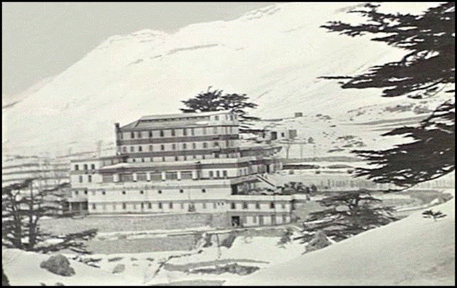
Hôtel des Cédres, Lebanon circa 1942.
Australian War Memorial image accession number 022355.
Major Hylton Ernest (HE) Williams (1898-1968) (formerly Headquarters Royal Australian Artillery, 9th Australian Division) replaced Major Savage as the Commandant of the Corps Ski School circa 24 January 1942. HE Williams was a keen alpine skier and an inaugural member of the Bogong Rover Crew that were the first to make a winter ascent of Mt Bogong in 1933. Major HE Williams was the son of Major General Robert Ernest Williams (1855-1943). Major HE Williams had served in the ranks during World War I and was awarded a Member of the British Empire for preparing speedy artillery fire plans in the second battle of El Alamein during October-November 1942. Apparently his superb effort here cemented the nick-name HE, the military acronym for high explosive. HE Williams retired with the rank of Lieutenant-Colonel (Nailer, undated).
As mentioned, initially Ski School students were accommodated in the French Barracks but they took their meals at the Hôtel des Cédres. However, the boilers at the Barracks failed leaving the student body without heating or hot water. As a consequence many caught heavy colds. From about 27 December 1941 the students were also accommodated at the Hôtel des Cédres.
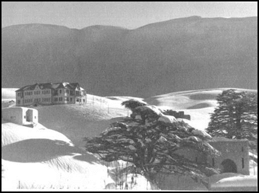
The former French Barracks near the Hôtel des Cédres, Lebanon circa 1942.
Image from Simon Pugh’s Mountain Warfare Training Centre website.
On 14 December 1941, Captain JS Cumpston together with 4 other officers and 5 non‑commissioned officers from the 9th Australian Division arrived at the 1st Australian Corps Ski School at The Cedars to undertake a preliminary training course that was concluded on 10 January 1942. Also at the School were 60 students from 6th Australian Division and 60 students from the 7th Australian Division (Australian Military Forces, 1941‑1942).
Around 15 December 1941 photographer James Francis (Frank) Hurley OBE (1885‑1962) visited the Ski School at The Cedars and took various still photographs as well as a movie film of activities. This material can be accessed from the Australian War Memorial website. Hurley was a member of Sir Ernest Shackleton’s (unsuccessful) 1914-1917 Imperial Trans-Antarctic Expedition. In a series of famous photographs over around 9 months in 1915 Hurley recorded the entrapment and eventual destruction of Shackleton’s vessel Endurance in the iced-up Weddell Sea.
On 24 January 1942, the 9th Australian Division was instructed to take responsibility for the 1st Australian Corps Ski School. To acquit this instruction the 9th Australian Division Ski Company was formed. This Company was commanded by Captain JS Cumpston and had a total establishment including all ranks of 202 men. Major HE Williams remained as the Commandant of the 1st Australian Corps Ski School which was apparently a separate establishment from 9th Australian Division Ski Company (Australian Military Forces, 1941‑1942).
The Nominal Roll of the 9th Australian Division Ski Company indicated that a total of 155 students passed the Ski School training tests (Australian Military Forces, 1942).
There was a fairly high drop-out rate amongst students of the 1st Australian Corps Ski School. Drop-out occurred due to injuries, student unsuitability, and requests for return to unit. In part the drop-out rate may have been due to the demanding physical training that students were subjected to from the start of their training where 7 or more hours per day of hard physical activity was involved. In the later British IX Army Ski School at The Cedars, the early physical demands on students were later substantially reduced during the early stages of the training to allow acclimatisation and to build up the students’ fitness.
Instructors* at the No 2 Course held at the 1st Australian Corps Ski School during 27 January-17 February 1942.
|
Rank and Name |
Comments |
|
Maj William James Riddell, Chief Instructor |
British Army, Ski Club of Great Britain, British Ski Champion, author, photographer |
|
A/Sgt John Abbottsmith |
24 Fd Pk Coy RAE (9 Aust Div), Instructor at Hotel Kosciusko Ski School, (post-war with ANARE Heard Island 1947-1948) |
|
A/Sgt Francis Due |
E Sec FSS HQ AIF (ME) Base Area, born Oslo, Norway |
|
A/Sgt George Edwick Derrick Stogdale |
2/11 Aust Army Fd Rgt (1 Aust Corps), Ski Club of Victoria, Australian Ski Champion |
|
A/Sgt Lindsay Sydney Salmon |
2/2 Aust Army Fd Rgt (6 Aust Div), Albury Ski Club, Secretary North East District Ski Association, Club Ski Champion, (post-war at Mt Hotham) |
|
A/Cpl Clas Fredrick Bruce Ostberg |
2/15 Aust Inf Bn (9 Aust Div), Australian born, Swedish Commissioned Officer |
|
A/Sgt Max Brandenberger |
2/24 Aust Inf Bn (9 Aust Div), born Zurich, Switzerland, Swiss Commissioned Officer, Swiss Alpine Ski Club, Manager Mt Buller Chalet |
|
A/Cpl Kare Gudbrand Nilsen |
2/15 Aust Fd Coy (1 Aust Corps), born Skein, Norway |
|
A/Cpl Olaves Martin Olsen |
Engr Tng Bn, born Borgestad, Norway, miner |
*In addition, from time-to-time various members of the 9th Australian Division Ski Company assisted with the instruction.
Source: Unit Diary, 9th Australian Division Ski Company, December 1941-February 1942.
Australian Forces leave the Middle East early 1942
Following the surprise attack on the United States Pacific Fleet at Pearl Harbour in Hawaii on 7 December 1941 and other Japanese attacks in the Asia‑Pacific region, the Australian Government decided to bring its Forces back from the Middle East to be better able to defend Australia itself. The return of Australian troops turned out to be a somewhat messy exercise. Australian Prime Minister John Curtin was opposed by British leader Winston Churchill who wanted to defeat Germany first…before committing any significant resources to the fight against Japan. Nevertheless most Australian troops had returned from the Middle East by March 1942. While the return of Australian troops was happening, Japan launched the first of its many World War II attacks on Australia with the bombing of Darwin on 19 February 1942.
British Army Ski Schools at The Cedars 1942-1944
After the Australians had withdrawn to defend their own country from the mounting threat from Japan, the Ski School at The Cedars continued from 1942 to 1944 under the British 9th Army. Initially it was known as the IX Army Ski School. During 1942-1943 it was named the Middle East Ski School and it was subsequently expanded to cover all aspects of mountain warfare. From January 1943 until its closure in late 1944 it was known as the Middle East Mountain Warfare Training Centre and included both ski and rock climbing training through a Ski Wing and a Mountaineering Wing. Separate chief instructors were appointed for the Ski and Mountaineering Wings. Between 1942 and closure in 1944 some 20 000 British and allied troops were trained.
With their planned World War II campaign into Europe from Italy, the British were looking to have suitably trained troops to combat the the German Alpenkorps (Alpine Corps) that had performed very well during World War I. In that conflict the British and their Allies had relied on French and Italian alpine troops but troops from these sources were unavailable in World War II. The British and Allied troops whom then had the most experience with snow and mountain conditions were Gurkhas who had served for many years in the North-West Frontier region of India (today the Khyber Pakhtunkhwa Province in Pakistan).
Under the British Army’s Middle East Mountain Warfare Training Centre the mountain training was conducted at The Cedars and at the two subsidiary centres, namely: Laqlouq and Sannine Camp. These two subsidiary centres are depicted on the above map of the location of The Cedars. From September 1943, the Chief Instructor, Rock Section was Major Anthony David Marchell (David) Cox, Royal Artillery. The ski training was primarily conducted at The Cedars. Major John Carryer, New Zealand Expeditionary Force, was the Chief Instructor of the Snow Section (Cox, 1992-93).
Commanding Officers (Commandants) of the British IX Army Ski School and successor establishments at The Cedars between 1942 and 1944 were:
· Captain Eric C C Thompson, Yorkshire Hussars (1942)
· Brigadier (later Major General) Arthur Wilmot Wadeson Holworthy DSO MC (1897-1983), 3rd Queen Alexandra's Own Gurkha Rifles (January‑July 1943)
· Lieutenant-Colonel Henry Nugent (Bunny) Head MC, 4th Queen's Own Hussars (later in 1943)
· Lieutenant-Colonel Robert C G Thompson (1944) (Jefferys, 2014; Pugh, undated).
Major James Riddell remained the overall Chief Instructor with the British Army Ski School and the later Middle East Mountain Warfare Training Centre. Major Riddell was awarded a Member of the British Empire in 1944. He was one of several interesting characters at the British ski and mountaineering training operation in Lebanon.
About William James Riddell (1909-2000)
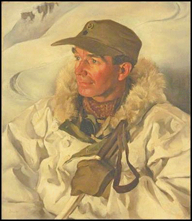
Major James Riddell Chief Instructor 1944.
A portrait by John Berry (1920-2009) from Imperial War Museum, London website.
James Riddell had been educated at the Harrow School in Middlesex and afterwards at Clare College, Cambridge University. As previously mentioned, he was a competitive skier from the late 1920s and British national ski champion in 1935. Riddell was vice‑captain of the English ski team at the 1936 Winter Olympics at Garmisch‑Partenkirchen in Bavaria.
Riddell was also a published author of numerous books, a photographer and later in life a painter. His books were mostly for children or on skiing-related matters. Two known exceptions were his 1950 book Flight of Fancy and his 1957 work Dog in the Snow: The Story of the Wartime Middle East Ski School.
Flight of Fancy is an illustrated travel tale of a 6-months return journey to Australia by Riddell and his friend Nevil Shute Norway (1899-1960). The journey started in September 1948 and was in Willie, Norway’s single-engine Percival Proctor V monoplane. The outward route was via India, Burma, Siam (Thailand), Malaya and Bali. On the return journey Willie was damaged when it ground-looped on landing at Brindisi a port on the Adriatic Sea in south eastern Italy. (A ground-loop is where aerodynamic forces on landing cause yaw and the leading wing rises and the other wing hits the ground, damaging or even cartwheeling the aircraft.) As a consequence of the damage to Willie, Riddell and Norway completed the last leg of their journey back to England on a commercial aircraft flight.
Nevil Shute Norway’s novel A Town Like Alice was written as a result of his travel to Australia with James Riddell in 1948-1949; the novel was published in 1950. That year Norway moved to Australia with his wife Frances Mary née Heaton (1901-1971), a medical practitioner and their two daughters. The family settled on farmland at Langwarrin, about 45 kilometres south east of Melbourne. Norway had started publishing novels under his given names circa 1924 while working with the aircraft manufacturer Vickers Ltd. While living in Australia during the final decade of his life Nevil Shute published several major novels including On the Beach in 1957, his last two novels were published posthumously (Croft, 2000).
Norway completed training at the Royal Military Academy, Woolwich in 1918 but was denied a commission because of a persistent stammer. Later he attended Balliol College, Oxford University where he studied engineering and graduated with a Bachelor of Arts in 1923. Initially he worked for the de Havilland Aircraft Company and also learnt to fly. Norway joined the Vickers Aircraft Company in 1924 as an aeronautical engineer. His work there included being chief calculator for inventor (later Sir) Barnes Neville Wallis (1887-1979) who was in charge of the design and construction of His Majesty’s Airship R100 (Croft, 2000). This rigid airship was built by the Airship Guarantee Company, a subsidiary of Vickers-Armstrongs Limited; its first fight was in December 1929.
In 1931 NS Norway co-founded the aircraft construction company Airspeed Limited with aircraft designer Alfred Hessell Tiltman (1891-1975). Norway had worked with Tiltman on the R100 airship project. Airspeed became a major British aircraft manufacturer and continued in operation until 1951 when it merged with de Havilland. Airspeed produced various types of military and passenger aircraft as well as sail planes and gliders. NS Norway resigned from the Board of Airspeed in 1938 and left with a generous financial settlement (Croft, 2000).
About Lewis Griffith CressweIl Evans Pugh (1909-1994)
Griffith Pugh in the 1930s.
Image from Mountain Warfare Training Centre website.
Griffith Pugh was the son of a barrister and attended the Harrow school in west London with James Riddell from 1924. Between 1928 and 1931 Pugh studied law at New College, Oxford University but then changed to medicine and spent three more years at Oxford before qualifying as a medical doctor at St Thomas's Hospital at central London in 1938.
Pugh was a keen skier while at University. He was chosen for the 18 kilometre cross-country event with the British ski team for the 1936 Winter Olympic Games that were held at Garmisch-Partenkirchen in Bavaria. However, Pugh was unable to compete in that event because of an injury. (James Riddell was vice-captain of the 1936 British ski team.)
Captain Griffith Pugh, then a doctor with the Royal Army Medical Corps, served as an instructor with the British Army’s Middle East Ski School in Lebanon from January to May 1943 and with the renamed Mountain Warfare Training Centre initially from May to June 1943. After service in Egypt and Sicily Pugh returned to the Mountain Wing, Mountain Warfare Training Centre as a physiologist between November 1943 and July 1944.
Pugh was called-up for service with the Royal Army Medical Corps in 1939. During World War II he also served in Greece, Crete, India, Ceylon, Palestine, Iraq and Iran. Immediately prior to Army discharge in 1945, Pugh was a member of a War Office committee that prepared a military training manual titled Snow and Mountain Warfare. The committee included other former Middle East Mountain Warfare Training Centre instructors James Riddell and David Cox.
In 1945 Griffith Pugh took up a post at the Royal Postgraduate Medical School at Hammersmith Hospital in west London (later known as the Postgraduate Medical School of London). By the end of 1950 Dr Pugh had moved to the newly created Division of Human Physiology at the Medical Research Council Laboratories at Holly Hill, Hampstead in the north west of London.
Mount Everest
Dr Pugh was involved on the ground with expeditions to Mt Everest and elsewhere in the Himalayas from circa 1951 to the early 1960s. He was formally asked to help with the scientific problems involved with the ascent of Mt Everest (8 848 metres or 29 029 feet) in December 1951. Pugh’s solution for the medical problem of The Last Thousand Feet at Everest led to its first ascent in 1953. (At the time Everest was said to be about 1 000 feet above other peaks in the Himalayas and accordingly there were major difficulties with the final part of the ascent.) Pugh's medical solution involved consuming 3 litres of water per day to prevent dehydration; ensuring a high carbohydrate food intake; and having appropriate insulation in clothing and in shelters (tents). He also devised rules for oxygen use above about 7 800 metres. These were that 4 litres per minute of oxygen should be used on ascent; 2 litres per minute on descent; and 1 litre per minute during sleep (Ward, 1993).
Griffith Pugh was a member (doctor and mountaineer) of the 1953 British Mount Everest Expedition led by Colonel John Hunt (later Brigadier Sir Henry Cecil John Hunt, Baron Hunt, KG CBE DSO [1910-1998]). With porters and guides there were over 400 people on this expedition that allowed (the later Sir) Edmund Percival Hillary (1919-2008) and Tenzing Norgay (circa 1914-1986) to make the first ascent of Everest on 29 May 1953.
Studies in Antarctica
In 1957 Pugh was asked by the University of California to join a physiological team working at the New Zealand Scott Base in Antarctica and associated with the Commonwealth Trans‑Antarctic Expedition. Pugh also visited the United States Amundsen–Scott Station at the South Pole a number of times and undertook research into the warming effect of solar radiation, into carbon monoxide poisoning in tents and into tolerance to cold.
The Amundsen–Scott Station was initially built by the United States Navy in 1956 for the International Geophysical Year (1957-1958), the Station has since been rebuilt on 2 occasions. Griffith Pugh was at this station on 19 January 1957 when the 12-man Trans-Polar party led by (the later Sir) Vivian Ernest Fuchs arrived on their epic trans-Antarctic crossing (Fuchs and Hillary, 1958, page 254). As part of Fuchs’ expedition, a 15-man Ross Sea party led by Sir Edmund Hillary had arrived at the Amundsen–Scott Station on 3 January 1957.
Dr Fuchs’ party was on a 3 470 kilometre overland crossing of the Antarctic continent from Flicher Ice Shelf at the head of the Weddell Sea to the New Zealand Scott Base at McMurdo Sound on the Ross Sea. (A crossing of Antarctica generally along this route had been planned by Sir Ernest Shacklelton [1874-1922] as the 1914‑1917 Imperial Trans-Antarctic Expedition. However, Shackleton’s vessel Endurance became trapped by ice in the Weddell Sea in February 1915 and sank in November 1915.) Fuchs’ depot on the Flicher Ice Shelf was named Shackleton Base.
On 26 January 1957, 2 days after leaving the Amundsen–Scott Station to continue their crossing journey, one of Fuchs’ party, engineer DL (Geoffrey) Pratt, was overcome by carbon monoxide in the cabin of Snow-cat Haywire and collapsed. After rudimentary first aid (oxygen) was given at the scene, Dr Pugh was flown to the site to attend Geoffrey Pratt (Fuchs and Hillary, 1958, page 273).
While at the United States Amundsen–Scott South Pole Station in January 1957, Griffith Pugh conceived with Sir Edmund Hillary the so called Silver Hut Expedition (Ward, 1995).
Silver Hut Expedition
The 1960-61 Himalayan Scientific and Mountaineering Expedition (known as the Silver Hut Expedition) studied the physiology of acclimatisation in human lowlander subjects at extreme altitude over a prolonged period. The Expedition also attempted to climb Makalu, an 8 470 metre peak about 19 kilometres south east of Mt Everest. The Expedition leader was Sir Edmund Hillary with Griffith Pugh as the scientific leader. Studies were conducted at a base camp in the Everest region of Nepal at 4 500 metres and at the Silver Hut (a prefabricated laboratory) at 5 800 metres on the Mingbo Glacier. Simpler physiology continued on Makalu in camps at 6 300 metres and at 7 400 metres (Milledge, 2010).
The Expedition left Kathmandu the capital of Nepal at the end of the monsoon in September 1960 and spent the autumn setting up the base camp and the Silver Hut. The first part of the Expedition was spent investigating the Yeti (abominable snowman) legend in the Rolwaling district of Sola Khummba (Pugh, 1962).
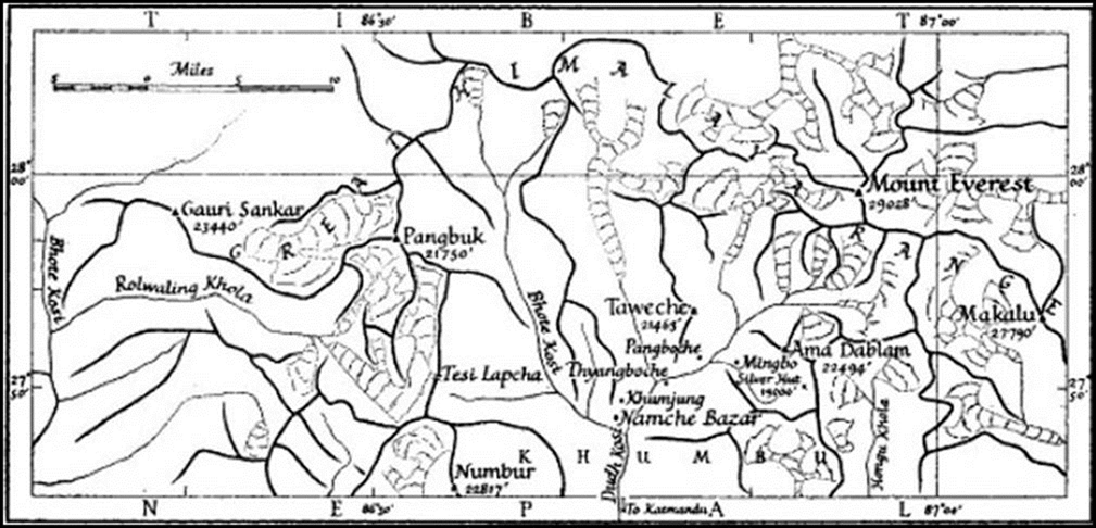
1960-1961 Silver Hut location map.
Map from Pugh, 1962.
The four-month winter was spent on physiological studies at base camp and in the Silver Hut. The nearby peak of Ama Dablam (6 812 metres) was climbed. In the spring the Expedition moved to Makalu and made an unsuccessful climbing attempt without supplementary oxygen. The 9‑month expedition ended at the start of the monsoon in June 1961 (Milledge, 2010; Pugh, 1962).
Dr Pugh’s ambitious program of studies was successfully completed examining the stress of altitude on each part of the transport system of oxygen in humans. The research produced new data on fundamental biological mechanisms and on sea‑level patients with heart and lung disease (Milledge, 2010; Ward, 1995).
Hypothermia studies
In the mid-1960s Dr Pugh investigated deaths of young people during adventure training in the British hills. At the time there was an average mortality of 30 deaths per year. Through a series of field and laboratory experiments Pugh showed that the cooling effects of wind, movement and wetting could rapidly lead to exhaustion and hypothermia even in above-freezing temperatures. As a consequence of Pugh’s investigation, the risk of death from hypothermia in the British Isles was greatly reduced (Ward, 1995)
Studies for Mexico City Olympic Games
Dr Pugh studied the effect of altitude on athletes' performance for the 1968 Olympic Games that were held at Mexico City which has a height of some 2 300 metres. He correctly predicted that the relative lack of oxygen would increase the times of long distance events but the lower air density would see a reduction in times for sprint events (Ward, 1995).
About John Abbottsmith (1918-1989)
Johnnie Abbottsmith circa 1947.
Image from The Australian Women’s Weekly.
Acting Sergeant John Abbottsmith was an instructor at the 1st Australian Corps Ski School in Lebanon from its inception in late 1941 and worked on manufacturing the necessary ski equipment before the School commenced operating in December 1941. He had joined the Second Australian Imperial Force in July 1940 at 21 years of age. Prior to joining the School, Abbottsmith was a Gunner with the 2nd/4th Field Park Company, Royal Australian Engineers (9th Australian Division). Engineers’ field park companies generally operated at the divisional level away from immediate combat activities to provide specialised workshops and to maintain divisional engineering assets.
John Abbottsmith saw active service during the Siege of Tobruk on the Mediterranean coast in Libya that ran from 10-11 April to 10 December 1941 when the last of the Australian forces were withdrawn. (The actual departure of Abbottsmith from this action is unclear but it was prior to the final Australian withdrawal.)
After the Ski School in Lebanon, John Abbottsmith was seriously wounded in action at El Alamein around October 1942 and was subsequently discharged from the AIF on 5 April 1943 as medically unfit.
With the Rag Tag Fleet
Later in 1943 John Abbottsmith joined the United States Army Service Forces and became an engineer on a Landing Ship-Tank. He joined the Service Forces in the New Guinea war zone and continued with them until his vessel was sunk during a landing in the Philippines.
In February 1942 the United States Army created the Services of Supply Branch that was renamed as the United States Army Service Forces in March 1943. The Forces operated in both the European and Pacific theatres and were abolished in April 1945 and absorbed into the United States Army.
During its two years of operation the Service Forces undertook numerous supply, administration and support tasks including transportation and supply of food, clothing, and munitions. For these tasks the Supply Forces operated a fleet of some 1 500 ships of various types (Millett, 1953). About 3 000 Australian civilians served in what was called the Rag Tag Fleet during this period including those who were too young, too old, or considered medically unfit for general defence service (White, 2017).
Early Life
John Abbottsmith was born at Tamworth on 16 August 1918. He was the second of the 6 children born to Frank Alexander Abbottsmith (1889-1967) and his first wife Enid Heath Abbottsmith née Teakle. John’s parents married at Kempsey in 1914 and divorced in 1932. Frank Abbottsmith was appointed as a licensed surveyor in New South Wales on 30 October 1912. He worked as a surveyor with the Lands Board (Department of Lands) at Hay and circa 1917 as a draftsman with the Board at Tamworth. Later he worked as a staff surveyor with the Department of Lands, from bases that included Forbes, Moree, Narrabri, Yass and Bega. While at Narrabri in the early 1930s Frank Abbottsmith advocated the potential for the nearby Mt Kaputar to become a world class tourist destination. Frank Abbottsmith also worked for the Department in the Snowy Mountains. Abbottsmith also contributed articles to local newspapers on geographical and exploration topics.
Prior to enlisting in the AIF, John Abbottsmith worked (when still a teenager) as a geologist’s assistant for a mining company in the Cooma area. Later he worked at the Hotel Kosciusko; initially as a grease monkey in the power house and later as a ski instructor. Between winter snow seasons, Abbottsmith made a few trips across the Pacific with the Niagara Steamship Company and worked with a mining company in Canada’s remote north-east.
(The State Government Hotel Kosciusko was located at the base of Mt Sunrise on the west side of Diggers Creek on the Kosciusko Road about 25 kilometres north west of Jindabyne. It opened in 1909 and was destroyed by fire around dawn on 18 April 1951. The staff quarters survived the fire and today remain as Sponars Chalet.)
Return to the Snowy Mountains
John Abbottsmith returned to the Hotel Kosciusko as a ski instructor in 1946. Here he met and married Phyliss (Phyl) Taylor who also worked at the Hotel. The Abbottsmiths’ first home was at Betts Camp (on the Kosciusko Road a few kilometres south west of Hotel Kosciusko). They lived there while John was employed by the Kosciusko State Park to install radios in mountain huts. (This park became the Kosciusko National Park in 1967 and the spelling was changed to Kosciuszko in 1997.)
To Heard Island
Around 1946-1947 John Abbottsmith apparently had several conversations with renowned geologist and Antarctic explorer Sir Douglas Mawson (1882-1958). As a consequence of these conversations Abbottsmith sought a place on the first Australian expedition to Heard Island.
Between 11 December 1947 and 14 February 1949, John Abbottsmith was one of the 14 men on the inaugural Australian National Antarctic Research Expedition to Heard Island, a barren volcanic sub-Antarctic island located in the Southern Ocean about 4 100 kilometres south-west of the Australian mainland. The expedition left Melbourne on 17 November 1947 in the 2 300 gross tons His Majesty’s Australian Landing Ship-Tank 3501 (later renamed HMAS Labuan) and returned to Melbourne in the same vessel on 28 February 1949.
Heard Island location map.
Note the Australian bases on Antarctica were established after the 1947-49 ANARE Heard Island expedition. Map source: Australian Antarctic Data Centre (Map 14237).
Abbotsmith (sic) Glacier on the western side of Heard Island runs from the slopes of Big Ben to the sea. This Glacier was named in 1948 for John Abbottsmith, a diesel mechanic with the ANARE Heard Island expedition. Abbotsmith Glacier is located at 53° 06' South Latitude, 73° 25' East Longitude. An image of the glacier is provided below. The image was captured by Alan Campbell‑Drury (1918-1994) who was a radio operator and photographer with the 1947-1949 Heard Island expedition. (While the Australian Antarctic Data Centre has noted the correct spelling of John’s surname it is unable to amend the erroneous spelling of Abbotsmith Glacier owing to this being perpetuated since 1948.) As well as being a diesel mechanic Abbottsmith also took part in exploration, mapping, geological and wildlife studies and carried out weather observations. He constructed a snow melter for water supply at the Expedition’s base at Atlas Cove.
Abbotsmith Glacier, Heard Island February 1949.
ANARE photo by Alan Campbell-Drury.
Map of Heard Island showing Abbotsmith Glacier.
Map source: Australian Antarctic Data Centre (Map 13099).
Apparently Abbottsmith was not happy with the way things had been managed during the Heard Island expedition. Abbottsmith’s concerns were the subject of correspondence to him from Sir Douglas Mawson in 1950 (Ayres, 1999, page 218).
Another return to the Snowy Mountains
Following his return from Heard Island, John Abbottsmith worked for the Water Conservation and Irrigation Commission of New South Wales measuring stream flows and heights in the Snowy Mountains. Later he established and operated a weather station at Spencers Creek (a few kilometres east of Charlotte Pass) for the Snowy Mountains Hydro-Electric Authority. Here John used a dog team for personal transport during the winter.
In the early 1950s John left the Snowy Mountains Authority and with Phyl and their four children moved to Smiggins Holes. Here they built a home and started the first Perisher-Smiggins ski lift that commenced operation in August 1952 and continued until 1959. John also continued to use his dog sled but as a public transport service from Smiggins Holes to Perisher until 1953 when the dogs were replaced with a Snowmobile that he operated until 1956.
The Abbottsmith family later left Smiggins Holes and established the Snowline Caravan Park, first at The Creel near the Thredbo River and later at the edge of Lake Jindabyne at the junction of the Kosciusko Road and the Alpine Way. This site was about 8 kilometres to the south of The Creel and about 3 kilometres west of Jindabyne town centre. (The now submerged Old Jindabyne was on the Snowy River just to the north of the present townsite. Old Jindabyne was closed in 1964 and Lake Jindabyne was created in 1967 as part of the Snowy Scheme.)
Vale
John Abbottsmith died at his Jindabyne home on 24 January 1989. He was 70 years of age. John was survived by his wife Phyliss and by three of their children, daughters Fay (Mrs Pendergas) and Diane (Mrs Hampshire) and son Garry. Another son, Ken, predeceased his father. John Abbottsmith’s remains were buried at the new Jindabyne cemetery.
Further information
More information on John Abbottsmith may be found via this link.