CHURCH MOUNTAIN REPORT
Dog Sledge Journey September 1962
DOG SLEDGE JOURNEY, MAWSON TO
CHURCH MOUNTAIN & MOUNT RIVETT
Introductory note for re-type January 2018.
The following text is an electronic copy of the Report produced at Mawson in 1962. It is taken from the handwritten, carbon copy, held by me; but follows the format of the typed copy. Some corrections and additional punctuation applied. Explanations added in [square brackets].
First Start Date 25 August. Second Start 3 September and completed 30 September.
Report was originally typed at Mawson by O.I.C. Commander F M. (Mike) Lucas RN (retired). Original and carbon copies. Diary is also typed to electronic media.
David Carstens.
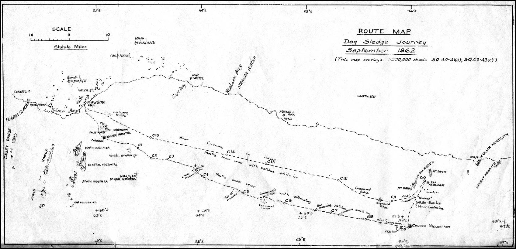
David Carstens’ route map of the September 1962 dog sledge journey from Mawson to Church Mountain and Mount Rivett.
Barometric heights at each of the camps are provided in the Appendix.
Cover page on OIC Typed copy:-
FIELD REPORT ------- 9/62
DOG SLEDGE JOURNEY
TO
CHURCH MOUNTAIN & MOUNT RIVETT
25 AUGUST -- 30 SEPTEMBER
1962
David Carstens
Leader
REPORT ON DOG SLEDGE JOURNEY FROM MAWSON TO MOUNTAINS EAST ONE HUNDRED MILES
PERIOD 25 AUGUST to 30 SEPTEMBER, 1962
Personnel David R. Carstens Leader, Surveyor
Ross L. Harvey Radio, Dogs
Kevin R. Miller Meteorology
Purpose The principal aim of the trip was to obtain two Astro-fixes for mapping control, one at Mount Rivett and the other at Church Mountain, one hundred miles east of Mawson. These features, and associated peaks, had never been visited previously on the ground to our knowledge. A Beaver Aircraft had force landed near Mount Rivett in 1958.
Meteorological observations were required from points more than fifty miles from Mawson.
Also included in our purpose was geology of the rock features visited and a search for lichens and mosses.
The journey also provided for good examination of the terrain.
Preliminary
The journey was originally proposed in Melbourne in conjunction with a proposed journey to the Amery Ice Shelf for glaciology and to prove whether a tractor train could be driven onto the ice shelf. At this stage it was assumed that the tractors would make their way to the Amery Ice Shelf by the shortest possible way.
At a conference at Mawson during changeover, Mr. Don Styles told us that he believed it was unsafe to travel eastwards from Mawson [with heavy vehicles] and he required that we should follow the southern route, which had been used out of Mawson since 1957, until Latitude 68°50′ approximately, and then head eastwards.
This left the closest Astro fix, that on Church Mountain, seventy miles north of the tractor route. The second Astro fix on Mount Rivett is another fifteen miles north. This put the required Astro-fixes out of reasonable reach of the tractor train or even a branch journey using dogs or vehicles.
In May 1962 it was proposed that a trip by Snow Trac could achieve an Astro-fix at Church Mountain in as little as five days. The Mount Rivett Astro would have to be neglected because of fuel capacity. [This followed favourable experience with the Snow Tracs.]
ANARE (Melbourne) would not approve this proposal, with danger to vehicles in unknown country as the main objection.
From Mawson it was then proposed that the two dog sledging teams which were to accompany the Spring Trip be routed via the two Astro-fixes and rendezvous with the Tractor Train (to Amery) at Depot C or thereabouts, due south from Church Mountain.
ANARE, once more, would not approve this plan stating that the Tractor Traverse would be placed in jeopardy if the dogs were held up along this route. ANARE proposed a separate dog journey from Mawson at this stage to do the two Astro-fixes.
This seemed very time consuming at an estimated time of four weeks, when the trip could be done in conjunction with the Spring Trip. By working in conjunction with the Spring Trip the dogs would have been saved up to 250 miles of running in this area. The journey Mawson to Astros to Depot C is shorter than Mawson to Astros and return.
It was decided to delete the Astro-fixes from the programme and ANARE and national Mapping were informed accordingly.
ANARE then signalled that Nat Map were most anxious to have the Astro-fixes and asked that we reconsider the possibility of doing them, but preferably by a separate trip.
This seemed to place more urgency on the trip and indicated that the length of time taken was unimportant. It also indicated that National Mapping approved of my neglecting the work around Mawson in favour of the two Astro-fixes.
It was decided that the journey to Church Mountain and Mount Rivett be undertaken.
At this stage the dog sledges were packed and ready to depart for Taylor Emperor Penguin Rookery, the planned departure date for this was 17 August, three days after the above decision was made.
The Astro-fixes were given priority on the use of the dog teams and the Rookery Trip was to be undertaken by vehicle at a deferred date.
Those involved on the Taylor Trip, and especially Ross Harvey and Kevin Miller, had put much time into the preparations and all equipment was organized. The only extra preparation required was the addition of one week’s supply of dog food and the Survey equipment.
I am very grateful to those concerned in the Rookery Trip, Dave Wigg, Ross, Kev, and John Watts, for so willingly altering their plans to suit this new journey.
I am sure it is not possible to add up the volume of work that has gone into preparing for this dog journey. I have had almost nothing to do with the work and would like to express my appreciation to Ross and all the others for all their work, which, in the end, was applied to make the survey work possible.
General
The details of the journey are covered by the daily Diary. The total time involved was five (5) weeks, although two weeks of this was dead time because of a false start. On this first occasion, we set out from Mawson using Snow Tracs to tow sledges up the first steep hill, two miles from Mawson. We then attempted to cover another ten miles up-hill [to Fisher Nunatak] with the fully loaded sledges. We were exhausted after the first seven (7) miles [including the dogs] and, into the bargain, broke a tent pole when pitching the tent in high wind. We continued to press on until after being held up for two days by weather, nine (9) miles east of Fisher Nunatak.
[The Diary gives the details of tying down the dogs, walking three miles to shelter at Fisher Nunatak, the arrangements for help and a replacement tent and the report of 80 MPH winds at Mawson when we were attempting to erect the tent.]
Consequently, we decided it was safer to return to Mawson rather than press on with limited food and resources. This took a week. Another week was spent reorganizing before making a second start on 9 September.
This time Snow Tracs took the bulk of our load to Fisher Nunatak, and this gave a good start on flat country with the heavy load. On this second trip no major holdup was caused by the weather and we were back at Mawson twenty-five (25) days after leaving. More time would have been desirable at Mount Rivett and nearby mountains, but shortage of dog food and kerosene made it desirable to cut the time, in that area, short. It was necessary to have a small reserve of food and fuel in case of bad weather on our return trip. Fortunately, we spent only one day tent bound on our way home.
Mawson to the two Astro-fixes and back to Mawson was 217 miles, as measured by the cyclometer [towed by the sledge]. The dogs performed well and are a very pleasant method of travel. Range with dogs is limited by not having depots or the advantage of air support.
Results
The two mountains, Church and Rivett, were Astro-fixed, Meteorological information obtained and, in many cases, this was passed back to Mawson by radio.
*Rock samples and lichens were collected on Church Mountain; but unfortunately, this aspect of the work had to be neglected for the other rock features.
The inwards and outward tracks were different, so we traversed a strip of three to six miles wide, on this section of the plateau. Our track is indicated on the accompanying map. [These tracks are now on the published Map Sheets.]
*Note; Our thanks are due to Davis Station, (VLZ) for working [Radio]Skeds with us and passing on our messages as radio conditions precluded contact with Mawson on all but a few occasions.
The Conclusions on Track
Although we crossed many crevassed areas with the dog sledges, these were obvious before we came to them. It was a matter of convenience and expediency, that these crevasses, which are all well bridged, were not avoided. It should be quite easy and safe to pick a vehicle route through to Church Mountain, using only small deviations from our dog sledging track.
Conclusions
Travel at this time of the year is strenuous. The cold drains one’s resources and the conditions of extreme cold for theodolite work render the operator and the instrument inefficient. The Kern Theodolite, itself, was very satisfactory, but fogging of the eyepieces and manipulation of instrument controls in the cold does not provide ideal observing conditions. The temperature at Church Mountain during observing times was between -25°F and -30°F and at Mount Rivett was below ‑30°F. In both cases a light breeze was present -- up to 15 knots at times.
Clothing and camping gear was found very adequate.
A notable feature, I feel, is that most things we thought we learned for ourselves on this trip, we subsequently discover, have been learned and recorded before. In many cases we had been told or read of these traps, etcetera, but the significance had not registered.
The twelve man-day food pack, as it exists, leaves one feeling hungry. I refer to my comments in the Daily Log. The addition of more HF6 Bar or pemmican is most important, because, even though one may not starve on the ration pack scale, there are enough discomforts while camping without having an empty feel in the stomach.
To twist the old cliché a little, I would conclude by saying:-Most of what we set out to do was achieved and much valuable experience was gained.
And one final quotation originating from Scott:-I do not regret this journey, how much better has it been than lounging in too great comfort at home.
D.R. Carstens
Surveyor
Statistics
22 Days for the Journey. 3 Days no move for Weather. 2 Days no move, Work. Average miles per running Day:-12.6 Statute Miles.
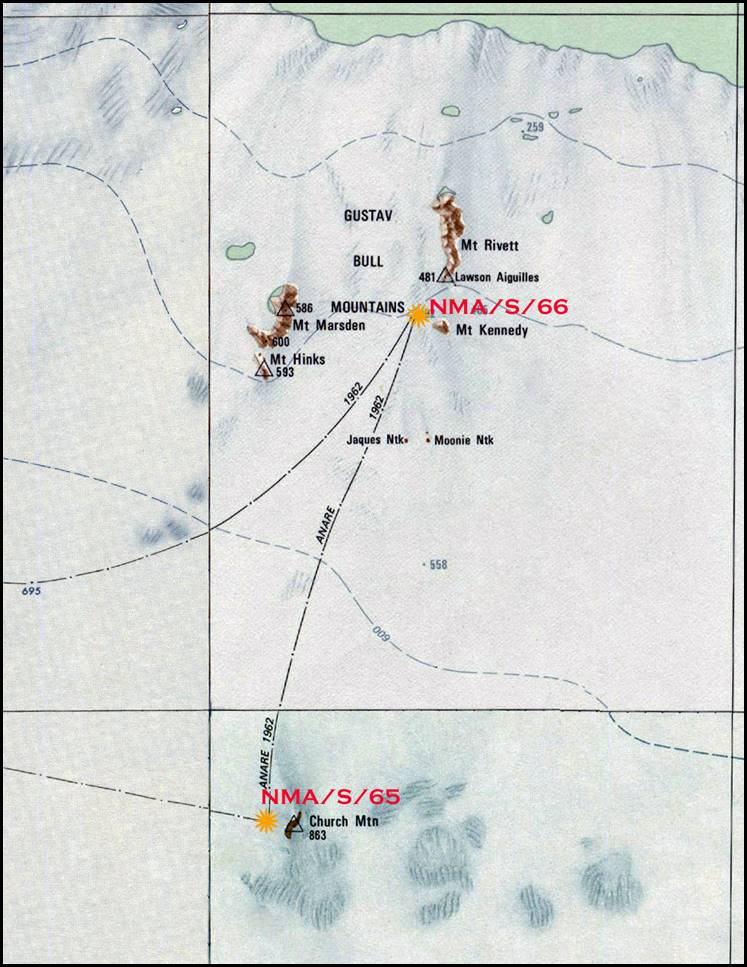
Locations of Church Mountain and Mount Rivett astrofixes 1962.
Diagram prepared by Paul Wise 2018.
Appendix
Mawson to Church Mountain and Mount Rivett
Dog Sledge Journey 1962
Barometric Height Readings at Camps
|
Camp |
Height (metres) |
Comment |
|
Z046 |
623 |
caravan near Fisher Nunatak |
|
1 |
662 |
|
|
2 |
751 |
|
|
2 |
770 |
|
|
4 |
815 |
|
|
5 |
802 |
|
|
6 |
829 |
|
|
7 |
819 |
|
|
8 |
809 |
|
|
9 |
814 |
near Church Mountain |
|
10 |
492 |
near Mt Kennedy |
|
11 |
693 |
|
|
12 |
694 |
|
|
13 |
645 |
|
|
14 |
674 |
|
|
15 |
680 |
|
|
|
|
|
Notes: This table was appended in 2018. During the 1962 dog sledge journey from Mawson to Church Mountain and Mount Rivett, surveyor David Carstens took barometric height readings in the evenings at each of his field party’s camps. The locations of these camps are depicted in the map at the front of this article.