Gordon Bertram Lauf : A brief profile
(13 May 1914 – 6 January 1984)
Background
Gordon Bertram Lauf was born on 13 May 1914, the son of Eugene Joseph Frederick Lauf (1874-1953) and Catherine Helena Viljoen (1878-1936), in Judith's Paarl. Judith's Paarl is a small suburb found on the eastern edge of the Johannesburg central business district (CBD), South Africa (please refer to Figure 1 below). Eugene Lauf was a scientific instrument maker, born in Stuttgart Germany in 1874. It is understood that he made lenses for various instruments, and kept a pet spider for the purposes of using the thread across the lenses (using a section of a spider’s web as the cross-hair in an instrument was common practice in the days before very thin wires or marks could be made). One of his daughters May, was responsible for feeding the spider!
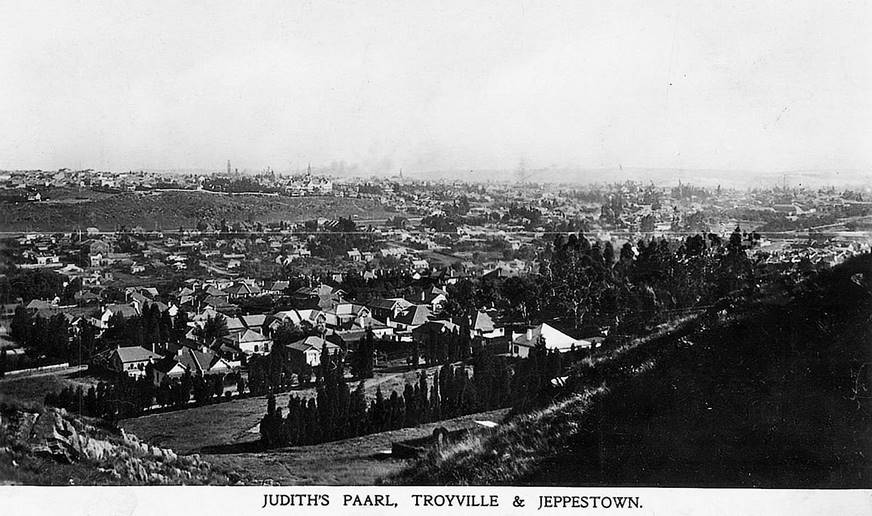
Figure 1 : Undated postcard of photograph, taken to the south, overlooking the early suburb of Judith's Paarl (foreground) from today’s suburb of Randview with Johannesburg CBD to right of frame.
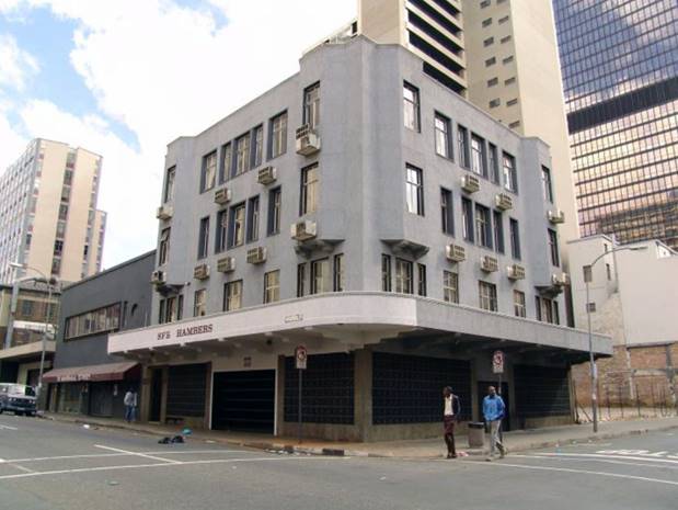
Eugene worked in the Johannesburg CBD at Survey House, on the corner of Marshall and Von Brandis streets, more detail is at Annexure A. Please refer to Figures 2, 3 and 4 below. Eugene had some contacts at Modderfontein chemical works, then the manufacturers of explosives for the South African mining industry. After his son’s first class matriculation results Eugene sent Gordon to apply for a job with the works but Gordon’s hopes were shattered when he was rejected despite his high grades. As a last resort Eugene sent Gordon to University; the rest as they say is history!
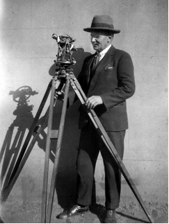
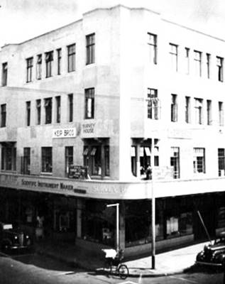
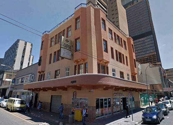
Figures 2, 3 and 4 : (left) Eugene Joseph Frederick Lauf with a theodolite; (centre) Survey House, Johannesburg (the signage reads Survey House and Eugene Lauf Scientific Instrument Maker); (right) building from 2015 Google Earth Street View.
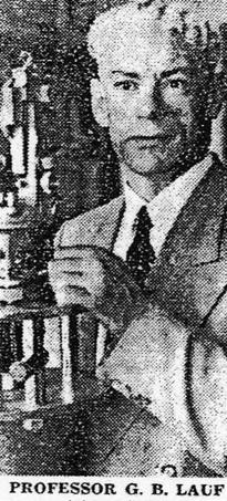
Curriculum Vitae : Professor G.B. Lauf (courtesy Vanessa Lauf)
Born : 13 May 1914
Education ;
Primary (1920-1926)
Secondary (1927-1931) : Transvaal Secondary School Certificate (First Class), Athlone Boys' High School, Johannesburg
Academic Qualifications :
B.Sc.(Eng) in the branch of Land Surveying (1932-1935, University of the Witwatersrand) : Degree conferred, with distinction
D.Sc.(Engineering) (1951, University of the Witwatersrand) Thesis : Conformal Transformations of Coordinate Systems
Employment :
Senator HSK Simpson, Dundee, Natal - Land & Mine Surveys : Articled Land Surveyor (December 1935 - June 1936)
H Nielsen & Partners, Johannesburg - Land Surveyors & Town Planners : Articled Land Surveyor (July 1936 - June 1937)
Victoria Falls & Transvaal Power Co. - Electricity suppliers : Land Surveyor (July 1937 - September 1938)
University of the Witwatersrand : Lecturer in Surveying (October 1938 – November 1952)
University of the Witwatersrand : Professor & Head of Department of Surveying (December 1952 – December 1975)
Professional Qualifications :
Registered Land Surveyor.
Registered Mine Surveyor.
Appointments :
Professor and Head of the Department of Surveying, University of the Witwatersrand, Johannesburg; The Origin and Development of Cartography, Inaugural Lecture delivered 23 June, 1955.
Dean of the Faculty of Engineering (3 years).
Chairman, Board of Control of the Library (10 years).
Head of the Chamber of Mines, Mine Survey Research Unit
Member, Commission of Enquiry into the Training of Land Surveyors
Chairman, Board for the Recognition of Land Surveyors Examinations
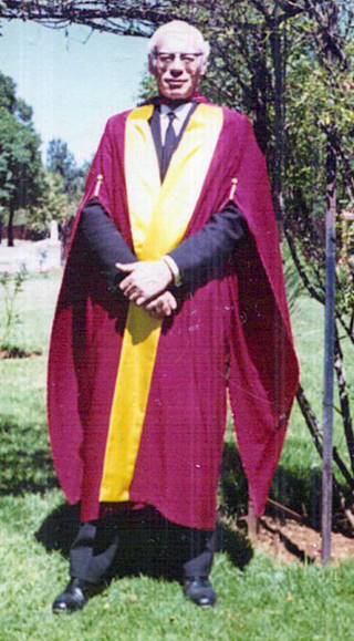
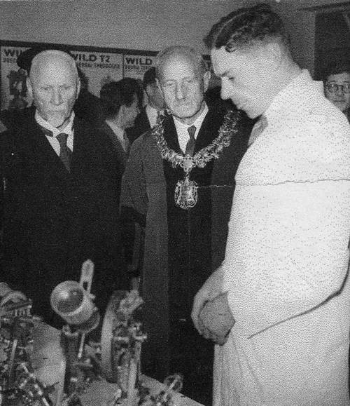
Figures 5 and 6 : (left) Gordon Bertram Lauf in his robes as Professor and Head of the Department of Surveying, University of the Witwatersrand, Johannesburg; (right) during a University Open Day demonstrating survey equipment to the then (far left) second Prime Minister of South Africa, Field Marshal The Right Honourable Jan Christiaan Smuts OM, CH, ED, PC, KC, FRS (24 May 1870 – 11 September 1950) and (immediate left) then Mayor of Johannesburg.
Professional and Technical Societies :
Fellow, Royal Institution of Chartered Surveyors.
President, Institute of Land Surveyors of the Transvaal.
President, South African Geographical Society.
South African Association for the Advancement of Science.
Associated Scientific and Technical Societies.
Photogrammetric Society (London & South Africa).
Institute of Mine Surveyors of South Africa.
Overseas Appointments and Visits :
United States National Science Foundation (Senior Foreign Scientist Fellowship) - Introduction of gyroscopic methods of surveying in the Colorado School of Mines.
United States Army, School of Artillery, Fort Sill, Oklahoma ‑ Course of Lectures on Gyroscopic Methods of Direction Finding for Artillery Purposes
German Foreign Scientist Fellowship : Manufacture and Testing of Gyroscopic Instruments.
Visiting Fellow, Royal Melbourne Institute of Technology, circa 1977-1979
Visited : Liverpool Tidal Institute, British Hydrographic Office, Taunton, England, German Hydrographic Institute, Hamburg, International Hydrographic Bureau, Monaco, - All for studies on Tidal Theory and Harmonic Analysis and Prediction of Tides.
Research :
Invented Lauf Method for the conformal transformation of coordinates from any orthomorphic map projection to any other map projection. This method is extensively used throughout Australia and other parts of the world. It is described in Bomford’s book on Geodesy.
Pioneered introduction of gyroscopic methods of surveying in the mines of southern Africa and the USA.
Text Books :
Geodesy and Map Projections, 1983, Commissioned by the Department of Surveying, Royal Melbourne Institute of Technology.
The Method of Least Squares with Applications in Surveying, 1983, Commissioned by the Department of Surveying, Royal Melbourne Institute of Technology.
Military (1944-1945) - World War II :
Designed new map projection for location of position of submarines by radar methods.
Attached United States Army Air Force, 310 Bombardment Group, for geodetic computations for 100 B26 Bombers for Shoran radar high precision bombing of targets in Northern Italy. The Group was part of the US 8th Army Air Force based in Corsica.
Post War :
Officer Commanding, 46 Survey Squadron.
United States Army : Santa Barbara Medal for services by a civilian to the United States Army.
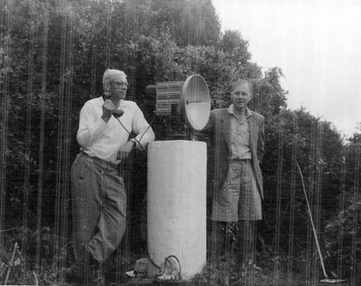
Figure 7 : Natal, Lauf (apprentice Tellurometer operator) with prototype Tellurometer and Mr Hendriks of the Trigonometrical Survey, measuring from base extension station Mjagatya to base extension station Entondweni (Trigonometrical distance 132,940.90 feet; Tellurometer distance 132,940.91 feet).
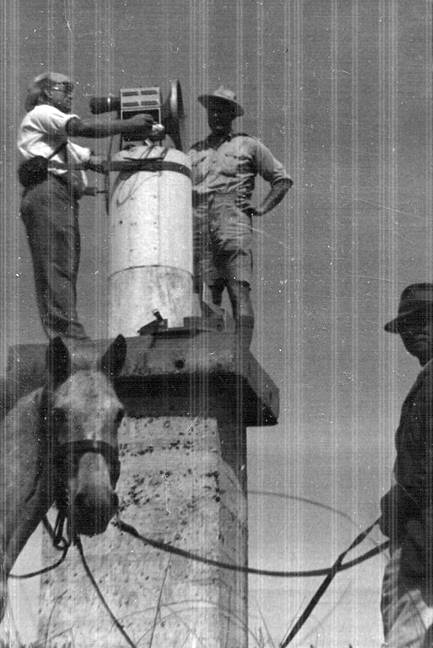
Figure 8 : Natal; Lauf (Tellurometer Operator (second class)) with prototype Tellurometer measuring line from base terminal station Pohla to base extension station Entondweni (Trigonometrical distance 65,105.80 feet; Tellurometer distance 65,105.81 feet).
Lauf’s Australian and National Mapping Connections
Gordon Lauf undertook a degree in Land Surveying between 1932 and 1935, graduating from the University of the Witwatersrand, Johannesburg, with distinction. After being employed by private practice as an articled pupil from 1935 to 1937, Gordon received his registration. He then joined a government utility working as a land surveyor for a further 14 months. Gordon was invited to become a junior lecturer at the University. He returned in October 1938 to the University of the Witwatersrand and became its Head of the Department of Surveying delivering his inaugural lecture on 23 June, 1955. He gained expertise with the Tellurometer, Gyro-theodolite (please see Annexure B for more detail) and developed the Lauf Method.
During the Second World War, Lauf went to Potchefstroom for basic training. By his own account, he initially trained as an Artillery Officer and saw service in North Africa and Italy in charge of an Artillery Survey Unit. Later he was attached to the United States 8th Army Air Force, 310 Bombardment Group, based in Corsica. Here he executed geodetic computations enabling Shoran controlled, high precision bombing, of targets in Northern Italy by 100 B26 Bombers (the Glen L Martin Company B26 Marauder became one of the finest medium bombers of World War 2. A long-range, twin-engined, light-to-medium bomber of considerable speed and capability to mount at least 2,000lbs of ordnance, the aircraft gained an impressive service record).
The official long name for Shoran is SHOrt-RAnge Navigation. However, former US navigators and bombardiers used the long form name SHOrt-Range Aid to Navigation. In mid-1940, Stuart William Seeley an engineer with the Radio Corporation of America (RCA), proposed building Shoran for the US Army Air Force and by late 1944 Shoran was in operation in Italy. With Shoran, the radar transmitting frequencies were switched in turn so that the ground station responders were alternately interrogated by the aircraft carried equipment, at intervals of a twentieth of a second. A positional accuracy of 20 yards in 200 miles (7 metres in 100 kilometres) or better than 1:15,000 could be achieved (Wise, 2016). Please refer to Annexure C for more detail about B26 Marauders and Shoran (SHORAN is an acronym as described above, and thus should be spelt in capitals. However, its common usage is to have only the first letter capitalised, Nevertheless, Shoran can be found written entirely in lowercase).
It was during this time with the US Air Force and working with Shoran, that Lauf encountered the problem of carrying out a conformal transformation. We had one radar station in Corsica, one in the Apennines and the target area was usually somewhere in Northern Italy, Lauf said (please refer to map at Figure 9 below). All three points were on different coordinate systems. Corsica was connected to the French triangulation, the Apennines to the Italian, and the target area to the Austrian system. At that stage we found only an approximate solution sufficiently accurate for military purposes and turned the problem over to a team of six mathematicians from various universities. The war ended before they found a solution. At war’s end Lauf carried the rank of Major and post-war was Officer Commanding, 46 Survey Squadron.
Gordon also spent some time in England with the British War Office and Air Ministry, London. Here he researched methods of radar position fixing aircraft whilst they were undertaking aerial photography (finding the position of an aerial photograph’s point of acquisition, was an age-old quest).
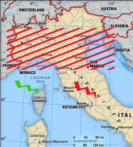
Figure 9 : Map of Northern Italy indicating the island of Corsica (green flash) the Apennines (red flash) and approximate WW2 target area (red diagonals)
It is clear that Colonel Harry Baumann, later Director of the South African Trigonometrical Survey, and Trevor Lloyd Wadley later of the Telecommunications Research Laboratory (TRL) and inventor of the Tellurometer, like Lauf, also had wartime experience with radar systems, specifically Shoran. Initially the Telecommunications Research Laboratory had been established in the Electrical Engineering Department at the University of the Witwatersrand. Trevor Wadley, who had shown great potential for research agreed to accept appointment and in 1946 the TRL commenced work. Because the Telecommunications Research Laboratory was within the Faculty of Engineering of the University, its staff came into close contact with members of the Faculty. One such contact developed between Trevor Wadley and Professor Gordon Lauf. Wadley believed that he could adapt the radar principles to making survey measurements over land. Baumann, now Director of the South African Trigonometrical Survey, came to hear about this idea, probably through Professor Lauf. Baumann thus initiated research by, in 1954, framing the operational requirements for a man-portable equipment for distance measurement i.e. Wadley’s Tellurometer released in 1957. Lauf was said to be initially sceptical that the required accuracy could be achieved and apparently, Lauf lost a wager with Wadley who proved to the contrary (McLean, 2015). Photographs of Lauf using a prototype Tellurometer can be viewed at Figures 7 and 8 above. The successful impact of the Tellurometer on the Australian geodetic survey and airborne Tellurometer (Aerodist) on control densification for National Mapping is now of historical record.
Lauf’s eldest son Deryck recalled meeting Trevor Wadley and further stated that like Wadley he had studied electrical engineering at the University of the Witwatersrand and later worked for the Council for Scientific and Industrial Research (CSIR) next to the University. In his final year of electrical engineering Deryck gave a presentation on the Tellurometer to his class.
Gordon Lauf eventually found a solution to the calculation of conformal transformations. It took him six years and was based on divided difference interpolation applied to a table of complex numbers. His solution formed the basis of a thesis for his Doctorate of Science in Engineering in 1951. Some of the results were published in 1961 in the Journal of the International Union of Geodesy and Geophysics (IUGG) and the applicable paper can be read via this link.
During his working life in gaining registration as a mine surveyor and as Head of the Chamber of Mines, Mine Survey Research Unit, Lauf had led the way introducing gyroscopic methods of surveying in the mines of southern Africa and the USA. Please refer to Figures 10 and 11 below. It was reported that : In early 1967 the Mine Manager's Association of the Broken Hill group of mines donated a Wild GAK 1 gyro-attachment and T16 theodolite to the University of New South Wales. At this time Professor GB Lauf of the University of the Witwatersrand visited this University and gave a series of lectures on his experiences with this and other types of gyro-theodolite. It was apparent from Professor Lauf's lectures that the gyro-theodolite was an instrument of great potential value to the mining surveyor.
While in Australia Lauf visited the Division of National Mapping in Canberra to discuss his work on transformations with AG Tony Bomford, who was in charge of the Division's geodetic section. Lauf said they had struck the same problem [in the calculation conformal transformations]. I told him my solution had already been published and gave him a copy. The arithmetical work required by the Lauf conformal transformation could either be done on a hand calculating machine or programmed for electronic computation and meant that a previously complicated method taking half an hour could be reduced to less than a second on an electronic computer. Natmap and the National Mapping Council thus adopted the Lauf Method of conformal transformation and it was published in the National Mapping Council’s 1986 Special Publication 10, The Australian Geodetic Datum – Technical Manual.
On 31 January 1948, Gordon had married Norma (nee Brittlebank, formerly of Liverpool) in Johannesburg. They had met in Aden during the war and Norma arrived in South Africa just prior to her wedding. The Lauf family migrated to Australia in 1976. Over the following three years Lauf occupied an Emeritus position, with Visiting Fellow status, at the Royal Melbourne Institute of Technology (RMIT). On completion of his tenure at RMIT, Gordon and Norma moved to the Sydney suburb of Cammeray to be closer to where some of their children were established. It was here that Gordon saw out his last years.
Figures 10 and 11 : (left) Gordon Lauf with a gyro-theodolite; (right) students of the Department of Surveying, University of the Witwatersrand, Johannesburg, learning how to use the gyro-theodolite.
Vale
Gordon passed away on 6 January, 1984 in Sydney, and his ashes are in the Northern Suburbs Crematorium. He was survived by his wife Norma and children Vanessa, Margaret, Deryck, John and Richard. At time of writing Norma is hoping to see 100yoa and so receive a message from the Queen.
Compiled by Paul Wise, 2017.
Acknowledgements
The assistance of Vanessa Lauf in supplying her father’s CV, photographs and other documents, Deryck Lauf, Rod Menzies and Laurie McLean in the preparation of this article is gratefully acknowledged.
Sources
Bomford, Guy (1971), Geodesy, 3rd Edn., Oxford at the Clarendon Press.
Lauf, Gordon Bertram (1955), The Origin and Development of Cartography, Professor of Surveying at the University of the Witwatersrand, Inaugural Lecture delivered 23 June, 1955, Witwatersrand University Press, Johannesburg.
Lauf, Gordon Bertram and Young, F (1961), Conformal transformations from one map projection to another, using divided difference interpolation, Bulletin Geodesique (International Union of Geodesy and Geophysics – IUGG, September 1961), No.61, pp.191-212.
McLean, Lawrence William (2015), The Aerodist Years : Recollections of the Division of National Mapping's Airborne Distance Measuring Program 1963-1974.
National Mapping Council (1986), The Australian Geodetic Datum – Technical Manual, Special Publication 10, 1986.
Styling, Mark (2008), B-26 Marauder Units of the MTO, Osprey Publishing, Midland House, West Way, Barley, Oxford, accessed at : www.39-45.org/videos/3945/CA073.pdf
Wise, Paul Joseph (2016), Airborne Electronic Distance Measuring : A Brief History.
Other sources :
http://www.ee.sun.ac.za/wp-content/uploads/downloads/2012/11/TL-Wadley.pdf
http://www.heavenaddress.com/restingplace/northernsuburbsmemorialgardens/gordon-bertram-lauf/736416
http://www.sage.unsw.edu.au/about/school_pubs/pdfrep/r15.pdf
Annexure A
Survey House : some history
(text and photograph extracted from : sfb chambers-2000s survey-bruwer.pdf (2006) at Standard Bank Chambers - The Heritage Register (www.heritageregister.org.za)
SFB Chambers on the corner of Marshall and Von Brandis streets was previously known as MAR Hall and Survey House. This location is in the township of Marshallstown, city of Johannesburg, region of Gauteng. The building was constructed in 1933 for £3000 with the architect being John Shaw (1908-1980) and had as its original owner Eugene Lauf. The building style was described as Art Deco – Monolithic. 1930s.
SFB Chambers on the corner of Marshall and Von Brandis streets, previously known as MAR Hall and Survey House
Initially constructed as a double story building it then comprised three shops at ground floor level with three showrooms above, a basement (storeroom) and balcony. This double story building was known as the MAR Hall and owned by Eugene Lauf. In 1935, an additional floor was added, comprising three showrooms, with a further floor in 1938. The entrance to the upper floors was off Marshall Street.
The building is protected under the general protection of Section 34(1) : Structure/s, of the National Heritage Resources Act, 1999.
It would appear from the 2015 Google Earth Street View image in Figure 4 of the main paper, that office space was being managed in the building then by Olitzki Property Holdings (OPH). At the time of writing, the building was occupied by The Graduate Institute of South Africa (https://www.google.com.au/maps/place/The+Graduate+Institute+of+South+Africa/@-26.207184,28.0449864,3a,75y,90t/data=!3m8!1e2!3m6!1sAF1QipOHX2lODrAcY8hZjorKzx7l2hf105BVNy1m1KE!2e10!3e12!6shttps:%2F%2Flh5.googleusercontent.com%2Fp%2FAF1QipOHX2lODrAcY8hZjorKzx7l2hf105BVNy1m1KE%3Dw203-h135-k-no!7i3840!8i2560!4m8!1m2!2m1!1sgraduate+institute+of+south+africa!3m4!1s0x1e950e9852ce0fc1:0x18a862ea002c4c2c!8m2!3d-26.20705!4d28.04493?dcr=0 )
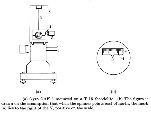
GAK 1 gyro-theodolite (after Bomford, 1971)
See Figures (a) and (b) below. The gyro attachment is mounted above an ordinary theodolite. The spinner is suspended by a fine tape (2) from a column (3) which moves with the upper part of the theodolite. A mark (4) on the spinner mounting can be seen through the viewer (5), as enlarged in Fig. 6.12 (b). The axis of the spinner is designed to lie in the same meridional plane as the line of sight of the theodolite when the mark (4) coincides with the V-notch (6) in the viewer, the zero of the scale.
The mounting of the spinner is attached to the bottom of the tape at a point above its mass centre, so the spinner axis is held substantially horizontal by gravity, and its only freedom is to rotate about a vertical axis.
A history of gyroscopes and their evolution into a surveying tool can be found in :
Grobler, Hendrik CI (2016), Azimuth determination by gyroscope, 50 years later, has anything changed?, Proceedings 16th International Congress for Mine Surveying, Brisbane, Australia, 12-16 September 2016, Section.3, pp.105-112, accessed at : https://www.ism2016.com/files/ISM2016/Proceedings/Section3/8_H_Grobler.pdf
Annexure C
(extracted from : Styling, Mark (2008), B-26 Marauder Units of the MTO [Mediterranean Theater of Operations])
On 10 March 1945, 320th Bomb Group (BG), Deputy Group CO Lt Col Larry Hayward, flying in the only Short Range Air Navigation (SHORAN) equipped Marauder then available - B26G-10 43-34463 BIN 45 of the 17th BG - led his group on its first Blind Approach Technique (BAT) bombing mission against the Hauenstein supply depot, which was covered by cloud. Three days later the 17th BG used the technique for the first time to bomb Bad Kreuznach, which was again obscured by solid cloud.
The driving force behind SHORAN was RCA Industry Service Laboratory scientist Stuart Seeley, who, in 1937, had been given the task of eliminating ghosts from television screens. These duplicate images are the result of reflected transmitter signals from buildings or other objects arriving at the receiver a fraction of a second later than the direct signal, thereby causing overlapping images on a TV screen.
During his experiments, Seeley deduced that the distance between the main image and the ghost on the screen could provide a means for measuring the extra distance travelled by the secondary image. If the position of the transmitter was known precisely, the distance measurement could indicate the source of the reflection. This phenomenon could, therefore, form the basis of an accurate system for measuring distances. Thus, SHORAN was born.
When equipped with SHORAN, an aeroplane could determine its precise position in any weather, day or night, by sending a signal to a pair of ground transmitters at known locations that reflected the signal back to its source. Seeley's new system was first tested in a B17 in August 1942, and the results achieved were amazing. SHORAN could, however, only be used against stationary targets, and it had a maximum range of 300 statute miles. It also needed a clear radio path (line of sight), which meant that the SHORAN-equipped bomber had to fly at an altitude of at least 14,000 feet, depending on the location of the ground sets.
The first combat mission using this technology was conducted on the night of 10 December 1944 when 57th Bombing Wing (BW) B25s operating from Corsica destroyed the Fidenza railway bridge near Bologna. Both the 17th and 320th BGs began training with the new system in late 1944, and they dropped their first practice bombs on 7 February 1945. When the two groups employed the system operationally, it would sometimes give a bombing accuracy of 99%.
A lead aircraft equipped with SHORAN would be the guide for the other B26s to drop their bombs. This was also the standard tactic used by a Norden-equipped aircraft, and because there were only a handful of SHORAN-equipped B26s in the ETO (European Theatre of Operations), it soon became common practice for a SHORAN-equipped Marauder from one unit to lead another squadron to its target.