THE DIVISION OF NATIONAL MAPPING’S PART IN THE GEODETIC SURVEY OF AUSTRALIA
ACTIVITIES BASED ON THE MELBOURNE OFFICE, 1951 - 1969
“The Australian geodetic network, a great part of it completed in ten years, must always be historically one of the survey wonders of the world."
Directorate of Overseas Surveys, Great Britain,
Information Service Newsletter, April 1974.
I understand that the original manuscript, including pictures, was rescued from destruction by John Ely and given to Ed Burke. Ed photographed each page with a digital camera and made these images available on CD. I was able to use Optical Character Recognition (OCR) software to convert the images to MS Word format which could be edited to include Reg’'s own corrections and some made by Ed and others. I later borrowed the original manuscript and scanned all the plates and figures to enable their reproduction at the best quality in this version. Des Young (saved HA Johnson slides and documents from destruction), John Allen, Adrian Wright, Jim & Helen Combe, Bob Goldsworthy (through Denyse Goldsworthy), Ed Burke, Bob Bobroff, Andrew & Murray Porteous, Peter Hocking (provided DR Hocking photos and documents), John Ely, Kevin Snell, Peter Langhorne and Terry Douglas provided the additional material appended at the end of each chapter.
It is duly acknowledged that copyright remains with Reg and apart from the edits described above, this document is a faithful reproduction of the original. This paper was also published in "The Australian Surveyor" of 1979, vol. 29, no. 6, pp. 375-427; vol. 29, no. 7, pp. 465-536; vol. 29, no. 8, pp. 581-638, reproduced with permission
Chapters
Forward and Closing Note (brought upfront to put paper in context)
Miscellaneous - Vehicles, radios, Weapons Research Establishment cooperation
(put upfront for easy reference)
1949 Bass Strait Reconnaissance and Marking
1951 Eyre Peninsula Triangulation
1952-53 Bass Strait Triangulation
1953 Minor Triangulation NT
1954 Broken Hill ‑ Orroroo ‑ Flinders Ranges Triangulation
1955 Broken Hill - Cobar and Marree ‑ William Creek Triangulation
1956 Eyre Peninsula - Gawler Ranges and William Creek – Rodinga Triangulation
1957 Rodinga ‑ Devils Marbles Triangulation, Tellurometer traversing NT and SA
1958 Triangulation NT, SA Border, Traversing NT, WA and SA
1959 Traversing NT, WA and SA
1960 Traversing NSW, Queensland, SA, NT and WA
Detailed map showing Natmap's progress to the end of 1960.
1961 Traversing NT, re‑observing SA and NT
Detailed map showing Natmap's progress to the end of 1961 (1961 work in red).
1962 Traversing WA, SA, NSW and Queensland
Detailed map showing Natmap's progress to the end of 1962 (1962 work in red).
1963 Traversing SA, WA and NSW, Beaconing Queensland
Detailed map showing Natmap's progress to the end of 1963 (1963 work in red).
1964 Traversing WA and Queensland
Detailed map showing Natmap's progress to the end of 1964 (1964 work in red).
1965 Traversing WA, SA, NT and Queensland (Final year of Primary Geodetic Survey)
Detailed map showing Natmap's progress to the end of 1965 (1965 work in red).
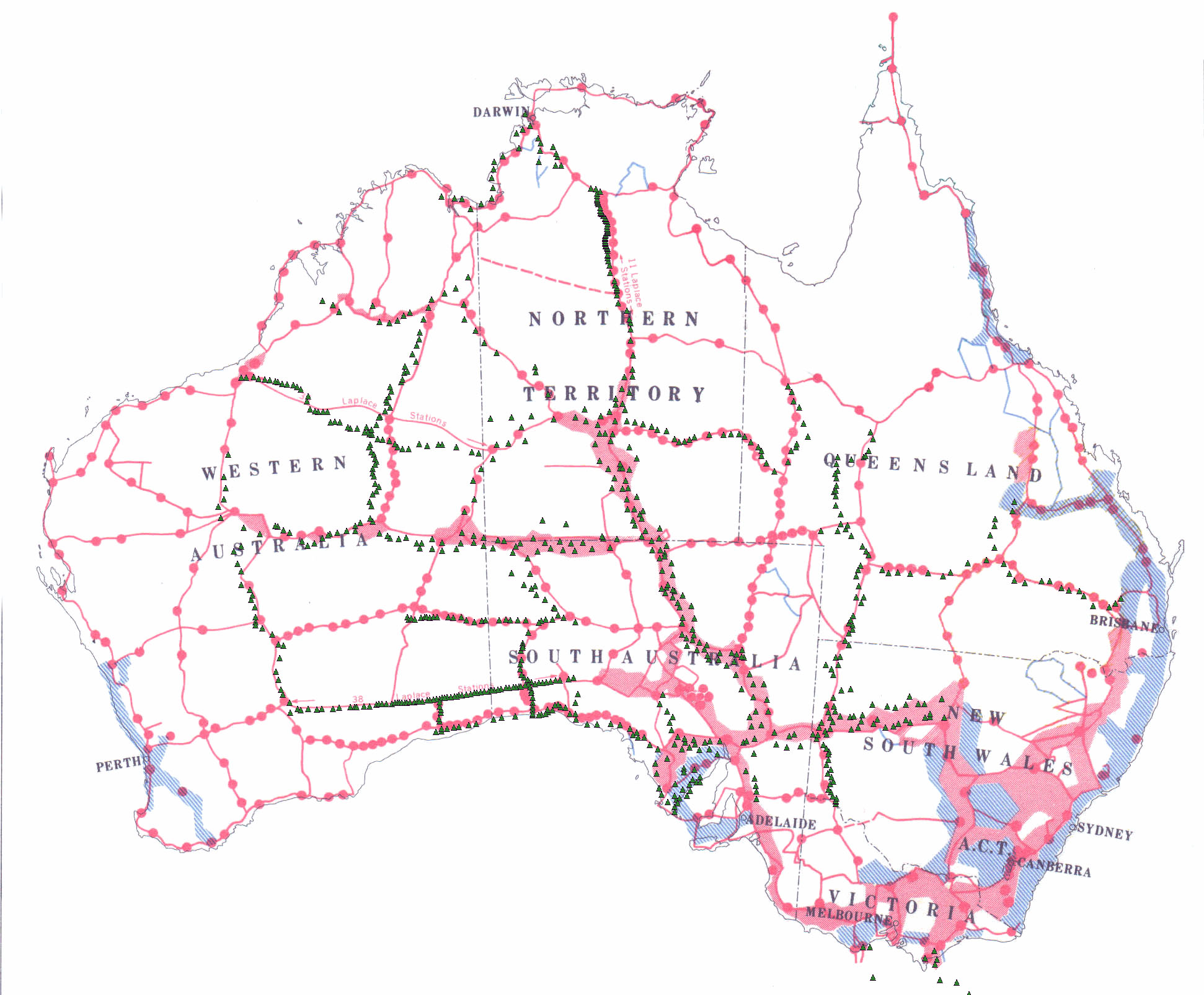
1966 Mapping control traverses WA, NT and Queensland, First Order connection NSW
Overview map showing Natmap's contribution to the primary loops of the Geodetic Survey of Australia allowing their adjustment in 1966.
Detailed map showing 1966 second order control work in black.
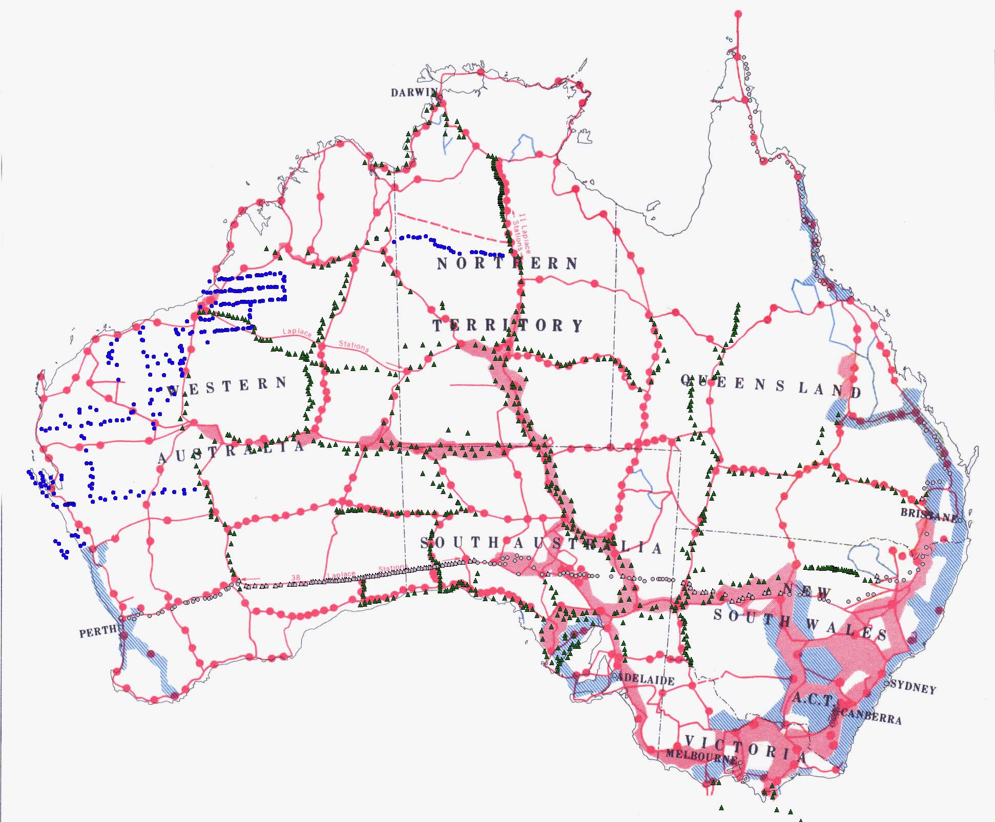
1967 First Order traversing NSW, High Precision measurements WA and SA, Mapping control traverses WA
Detailed map showing 1967 second order control work in blue.
1968 High precision measurements and traversing SA, NSW and Queensland, Mapping control traverses WA
Detailed map showing 1968 second order control work in red.
1969 High precision traversing NSW and Queensland, simultaneous reciprocal azimuths along all lines Caversham WA to Culgoora NSW
Detailed map showing 1969 high precision work
Overview map showing Natmap's contribution to the Geodetic Survey by green triangles and survey and map control by blue triangles at the end of 1969.